
Order Total (1 Item Items):
Shipping Destination:

Waldeseemuller (3 results)
Skip to main search results
Search filters
Product Type
- All Product Types
- Books (No further results match this refinement)
- Magazines & Periodicals (No further results match this refinement)
- Comics (No further results match this refinement)
- Sheet Music (No further results match this refinement)
- Art, Prints & Posters (No further results match this refinement)
- Photographs (No further results match this refinement)
- Maps (3)
- Manuscripts & Paper Collectibles (No further results match this refinement)
Condition Learn more
- New (No further results match this refinement)
- As New, Fine or Near Fine (No further results match this refinement)
- Very Good or Good (No further results match this refinement)
- Fair or Poor (No further results match this refinement)
- As Described (3)
Binding
- All Bindings
- Hardcover (No further results match this refinement)
- Softcover (No further results match this refinement)
Collectible Attributes
- First Edition (No further results match this refinement)
- Signed (No further results match this refinement)
- Dust Jacket (No further results match this refinement)
- Seller-Supplied Images (3)
- Not Print on Demand (3)
Language (1)
Price
- Any Price
- Under US$ 25 (No further results match this refinement)
- US$ 25 to US$ 50 (No further results match this refinement)
- Over US$ 50
Free Shipping
- Free Shipping to U.S.A. (No further results match this refinement)
Seller Location
Seller Rating
-

Mapa Universal de 1507 (Primero con el nombre de America). Reproduccion reducida y comentarios por Carlos Sanz
Published by Graficas Yagues, S.L. Plaza Conde Barajas,, Madrid,, 1959
Seller: Daniel Crouch Rare Books Ltd, London, United Kingdom
Association Member: ABA ILAB PBFA
Seller rating 4 out of 5 stars

Map
US$ 5,542.03
US$ 26.90 shipping
Ships from United Kingdom to U.S.A.Quantity: 1 available
Add to basketThe fourth part of the earth, we have decided to call Amerige Large lithographed wall-map in 12 sheets (each sheet 480 by 650mm). A faithful full-sized facsimile of Waldseemuller's iconic 1507 woodcut map: "Universalis Cosmographia Secundum Ptholomaei Traditionem et Americi Vespucii Alioru[m]que Lustrationes", the only known example of which is now on display at the Library of Congress. Waldseem�ller's map is the first to name the separate continent of the New World "America", and the first map, printed or manuscript, to depict clearly a separate Western Hemisphere and a separate Pacific ocean. Until the printing of this map the world was understood to consist of only three parts: Europe, Asia, and Africa. Martin Waldseem�ller (1470-1521) was a German scholar and cartographer. He studied under Gregor Reisch at the University of Freiburg, and then moved to Basel in the late 1490s, where he met the printer Johannes Amerbach. In 1506 he moved to Saint-Di� in Lorraine, where Duke Ren� II had established a humanist academy, the Gymnasium Vosagense. There he read about Amerigo Vespucci's voyage to the Americas, and Portuguese accounts of circumnavigating Africa. Together they proved that the Indian Ocean was not landlocked. He and his colleagues decided to create a map which compared Vespucci's geographical information with Ptolemy's, along with an explanation of why they had deviated from Ptolemy's precepts. This work, 'Cosmographia introductio', was published in 1507. It contains the first printed instance of the name 'America' being applied to the discoveries over the Atlantic: "The fourth part of the earth, we have decided to call Amerige, the land of Amerigo we might even say, or America because it was discovered by Amerigo". The book was accompanied by a set of small woodcut map gores, the first known printed gores for a terrestrial globe ever made, which showed a landmass meant to represent South America labelled as 'America'. The globe gores were a companion to the 'Universalis cosmographia', the great world map in twelve sheets by Waldseem�ller. It was unusually large for a woodcut map, and drawn using an adaptation of the second method of projection advocated by Ptolemy. It shows the Americas as one contiguous continent, and was the first map to give this name to the new discoveries. Waldseem�ller himself was reluctant to identify America as a continent, and would never use the name America in any of his later work. When he finally published his edition of Ptolemy in Strasbourg in 1513, he labelled South America "Terra Incognita". However, nearly every significant mapmaker for the next quarter of a century relied on his work, popularising his geography and terminology. Although 1,000 copies of the 'Universalis cosmographia' were printed according to Waldseem�ller, only one survives. It was sold to the Library of Congress for $10 million in 2003.
-
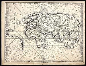
Orbis Typus Universalis Iuxta Hydrographorum Traditionem.
Published by Johannes Schott, 12th March, 1513, Strassburg,, 1513
Seller: Daniel Crouch Rare Books Ltd, London, United Kingdom
Association Member: ABA ILAB PBFA
Seller rating 4 out of 5 stars
Map
US$ 110,840.69
US$ 26.90 shipping
Ships from United Kingdom to U.S.A.Quantity: 1 available
Add to basketThe Admiral's map Double-page woodcut map of the world, lower margin extended. The so-called Admiral's Map; the first of two maps in Waldseemuller's atlas that relate New World discoveries, and is referred to in the index as the 'Hydrographia sive Charta marina', and in the 'Ad Lectorem' as the 'Charta Marina', where it is clearly stated that the geographical facts have been made known "through the most authentic voyages of a former Admiral of the most serene King of Portugal, Ferdinand, and those of other explorers" (The Admiral's Map What Was It? And Who the Admiral? Samuel Mc Coskry Stanton, Isis, Vol. 22, No. 2. (Feb., 1935), pp. 511-515). The map was created for inclusion in the Strassburg edition of Ptolemy's 'Geographia', signaling the beginning of the section of twenty modern maps which were added to the twenty-seven Ptolemaic originals. This world map gives a more accurate outline of eastern Asia than Ptolemy. It contains Greenland, which is attached to Europe, but only a tiny section of North America, meant to represent either Newfoundland or Labrador. The coastline of South America is left unfinished, and only five place names are given. Martin Waldseem�ller (1470-1521) was a German scholar and cartographer. He studied under Gregor Reisch at the University of Freiburg, and then moved to Basel in the late 1490s, where he met the printer Johannes Amerbach. In 1506 he moved to Saint-Di� in Lorraine, where Duke Ren� II had established a humanist academy, the Gymnasium Vosagense. There he read about Amerigo Vespucci's voyage to the Americas, and Portuguese accounts of circumnavigating Africa. Together they proved that the Indian Ocean was not landlocked. He and his colleagues decided to create a map which compared Vespucci's geographical information with Ptolemy's, along with an explanation of why they had deviated from Ptolemy's precepts. That work, 'Cosmographia introductio', was published in 1507. It contains the first printed instance of the name 'America' being applied to the discoveries over the Atlantic: "The fourth part of the earth, we have decided to call Amerige, the land of Amerigo we might even say, or America because it was discovered by Amerigo". The book was accompanied by a set of small woodcut map gores, the first known printed gores for a terrestrial globe ever made, which showed a landmass meant to represent South America labelled as 'America'. The globe gores were a companion to the 'Universalis cosmographia', the great world map in twelve sheets by Waldseem�ller. It was unusually large for a woodcut map, and drawn using an adaptation of the second method of projection advocated by Ptolemy. It shows the Americas as one contiguous continent, and was the first map to give this name to the new discoveries. Waldseem�ller himself was reluctant to identify America as a continent, and would never use the name America in any of his later work. When he finally published his edition of Ptolemy in Strasbourg in 1513, he labelled South America "Terra Incognita". However, nearly every significant mapmaker for the next quarter of a century relied on his work, popularising his geography and terminology. Sabin 66478; Shirley 35.
-

Tabula Moderna Norbegie et Gottie.
Published by Johann Schott, 1513]., [Strassburg,, 1513
Seller: Daniel Crouch Rare Books Ltd, London, United Kingdom
Association Member: ABA ILAB PBFA
Seller rating 4 out of 5 stars
Map
US$ 11,084.07
US$ 26.90 shipping
Ships from United Kingdom to U.S.A.Quantity: 1 available
Add to basketWaldeseemuller's map of Scandinavia Double-page woodcut map. Waldeseemuller's strking map of Scandinavia. This work was based on the manuscript maps of Sanuto and Vesconte of c.1320, which were updated by Nicholaus Germanus in 1482 to include more cities and textual information. As noted by Ginsberg: "Waldseemuller's map . . .appeared in the supplmental section of modern maps. A faithful coy of the Ulm map published thirty-one years earlier, it too, is a woodcut. The title, however, differs from the Ulm 1486 edition by no longer referring to Prussia and Livonia. As on the 1482 map, Norway is shown as "norbegia." Most of the same cities are also included-- "asto" (oslo, 'begensis" (Bergen), Nodrosia (Niadros or Trondheim), and "Stauargnsis.". The lines to text in letterpress on the right-hand side that specify lines of parallel and lengths of days have been retained". Ginsberg, Scandinavia 5.