
Order Total (1 Item Items):
Shipping Destination:

Wall Map (121 results)
Author:
wall map
Refine with Advanced Search
Skip to main search results
Search filters
Product Type
- All Product Types
- Books (6)
- Magazines & Periodicals (No further results match this refinement)
- Comics (No further results match this refinement)
- Sheet Music (No further results match this refinement)
- Art, Prints & Posters (No further results match this refinement)
- Photographs (No further results match this refinement)
- Maps (115)
- Manuscripts & Paper Collectibles (No further results match this refinement)
Condition Learn more
- New (No further results match this refinement)
- As New, Fine or Near Fine (No further results match this refinement)
- Very Good or Good (3)
- Fair or Poor (No further results match this refinement)
- As Described (118)
Binding
Collectible Attributes
- First Edition (15)
- Signed (2)
- Dust Jacket (No further results match this refinement)
- Seller-Supplied Images (118)
- Not Print on Demand (121)
Language (1)
Free Shipping
- Free Shipping to U.S.A. (No further results match this refinement)
Seller Location
Seller Rating
-

Illustrated Chart Showing 5000 Years of the History of Mankind *
Published by Book Enterprises Staff, New York 17, New York * * * * *
Map
Soft cover. Condition: Very Good. Lowell Hess and Louis Caluek, Designed By Wall Map, Very Good/ (illustrator). Wall Map, Very Good/ $29.82 Illustrated Chart Showing 5000 Years of the History of Mankind * Book Enterprises Staff Lowell Hess and Louis Caluek, Designed By Book Enterprises New York 17, New York * * * * * Folding Wall Map, 48 Inches X 35 Inches. In Very Good Condition. Small Tears On Two Of The Folds. In Very Good/ Condition. Light Age Spotting On Page From Aging. UnBound. D/j: None. This Is * * An Original Edition, * * Not A Secondary Market Or More Modern RePrint. This Item Will Be Sent Wrapped In Plastic, Taped Shut And In A = * * ~ Padded Mailing Envelope * * To Prevent Shipping Damage So That It Will Arrive In The * * Description Described Which Applies To This Map, Only. * = No Odors, No Writing, No Other Names, No Rippling, Not Stuck Together, Not X~Library, No Other Marks. = Will Make It, An Excellent Addition To Your Own Personal Library Collection, Or As A Gift, For The Discriminating Reader / Collector. = WORLD WIDE SHIPPING, AVAILABLE.
-
Map. Condition: Very Good. Please note, this is the version that includes continent and special maps- also indexes and chronology of events since world war II.Listed as very good due to slight discoloration of cover page.
-
![Seller image for Engraved map, dated 5 April 1786, captioned 'A Map of the Channels and Lands from Appledore Dowls [Kent] and Black Wall to Rye Harbour [Sussex].' [Illustrating proposed embanking and a new cut to the River Rother.] for sale by Richard M. Ford Ltd](https://pictures.abebooks.com/inventory/md/md32358932227.jpg)
Engraved map, dated 5 April 1786, captioned 'A Map of the Channels and Lands from Appledore Dowls [Kent] and Black Wall to Rye Harbour [Sussex].' [Illustrating proposed embanking and a new cut to the River Rother.]
Published by '5th. April', 1786
Seller: Richard M. Ford Ltd, London, United Kingdom
Seller rating 5 out of 5 stars

US$ 207.25
US$ 6.04 shipping
Ships from United Kingdom to U.S.A.Quantity: 1 available
Add to basketNicely printed on thick watermarked laid paper, roughly 56 x 78 cm. Plate dimensions roughly 40.5 x 64 cm. Even creases from folding of map four times. Fair, with a little discoloration along folds and very slight wear and loss fold junctions. At foot of plate: 'The Scale is 96 Rods to One Inch.' Only two copies of this item located: the first, in the British Library Department of Maps describes it as showing 'existing and intended drainage systems. Engraving style and date suggests hand of Charles John Downes, engraver for maps accompanying Hasted's History of Kent'. The other reference to a copy (RYE/132/25, 26) in the Archive of Rye Corporation, at East Sussex Record Office, the entry for which states that the map 'Shows principal sewers, bridges and sluices to illustrate proposed embanking of Salts Channel W. of Five Waterings Sluice and Sewer in Playden and Iden, and a new cut to the Rother. Conventional drawings of churches, houses and mills with their names.' The second description refers to a 'separate printed estimate of the expense of the works', not present here. Captions include 'Late Mr. Jewhurst's now Clark's' and 'Where Craven Sluices did lay'. See Image.
-
One of the most influential maps of America ever made.
Published by Bologna, Guiseppe Longihi, Pietro Todeschi, 1673
Seller: Antiquariaat de Roo, Zwijndrecht, Netherlands
Seller rating 4 out of 5 stars

First Edition
US$ 89,119.48
US$ 26.62 shipping
Ships from Netherlands to U.S.A.Quantity: 1 available
Add to basket"[Nova et accurata totius Americae tabula auct. G. I. Blaeu] America quarta pars orbis quam plerunq, nuvum orbem apellitant primo detecta est anno 1492 a Christophoro Columbo []. A hand-coloured engraved wall map, printed on 4 joined sheets. Size: 86 x 110 cm. / 33.9 x 43,3 inch. Large, very rare, hand coloured copy of Willem Blaeu's famous wall map of the Americas, which is considered "one of the most influential maps of America ever made" (Burden). The map is based on the latest explorations and shows everything known at the time about the American continent, as well as the north and south poles, which are included on two inset maps. As the wall map was in great demand, but expensive and difficult to transport, it was also printed by various French and Italian publishers for the local market. Like Blaeu's edition, the French and Italian editions are very scarce, as it is highly unusual for wall maps from this period to survive. We have only been able to trace 4 other copies of the present edition in sales records of the past hundred years, of which only 1 is also hand coloured. Willem Janszoon Blaeu (1571-1638) first published the wall map in 1608, together with similar maps of Asia, Africa, and Europe. He spared no expenses for this project and hired Hessel Gerritsz (1580-1632), a great cartographer in his own right, to both design the maps and research the latest sources exhaustively, to create the most accurate depiction of the continents possible. Although the Americas were drawn too wide due to the inadequate methods of determining longitude at the time, the shapes and most of the coastline are already very well defined. Central and South America were drawn according to Portuguese and Spanish sources, and "Nova Scotia" on the Atlantic coast was based on the voyages of Samuel de Champlain and Pierre Gua de Monts from 1604. After the first edition in 1608, the four continents were subsequently published in 1612, and in 1624 they were reissued by Hendrik Hondius and in 1655 by Nicholas Visscher. The third state included changes to the Strait of Magellan based on Le Maire's findings from his expedition in 1615-1617. The map has been beautifully decorated with cartouches and small engravings. The cartouche in the lower right tells how the New World was discovered, and is flanked by the figures of Christopher Columbus and Amerigo Vespucci. Below are four roundels containing the portraits of the four circumnavigators: Ferdinand Magellan, Sir Francis Drake, Sir Thomas Cavendish, and Olivier Van Noort. The Atlantic features a beautiful depiction of King Philip III of Spain riding a sea chariot, supposedly on a figurative visit to his New World possessions, and in the Pacific Poseidon with his wife Amphitrite and son Triton can be found, amidst battle ships and sea monsters. Elephants, rhinoceroses, camels, and ostriches roam the continent. Some copies of the present map include a decorative border with illustrations of native people, and sometimes also a textual border with descriptions, which are not present here. It appears that these borders were engraved on separate copper plates and were not always included. Blaeu's wall maps were first printed in Italy in 1646, probably by Stefano Mozzi Scolari (1598-1650) in Venice, which were based on the third state from 1624. The present copy was engraved by Pietro Todeschi (dates unknown) around 1670, and published in Bologna in 1673, probably by Giuseppe Longhi, who had worked on similar projects with Todeschi before. It closely resembles the Venetian edition, which was most likely used as the model. Todeschi's edition is, however, clearly recognizable because of the misspelling of Mar del Norte as Mar del Noi, and the fact that California has been drawn as an island. It is the only edition known to do so. The map has been reinforced on the back, and is somewhat browned and stained; the surface has faded, the work has been professionally restored: the colouring has been retouched, some of the losses have been filled in. Otherwise, in good condition. Burden II, 433; Schilder, Monumenta cartographica Neerlandica V, p. 195; cf. Burden I, 156 (Blaeu map).".
-
![Seller image for [Kingdom of Ayutthaya]. for sale by Geographicus Rare Antique Maps](https://pictures.abebooks.com/inventory/md/md32307609487.jpg)
[Kingdom of Ayutthaya].
Publication Date: 1957
Seller: Geographicus Rare Antique Maps, Brooklyn, NY, U.S.A.
Association Member: ABAA ESA ILAB
Seller rating 4 out of 5 stars
Map
Soft cover. Average. Manuscript. Overall toning. Color loss and surface scuffing. A few small holes. Laid down on old linen. Size 43 x 31.5 Inches. This is a large-format Thai-language c. 1957 manuscript historical wall map of Southeast Asia. It depicts the historical Kingdom of Ayutthaya, forerunner to modern Thailand, with a very generous border, a reflection of the ideological values of Pan-Thaiism. A Closer Look The map presents an aggrandized view of the territory of the Kingdom of Ayutthaya (1351 - 1767), stretching from what is today southern China to the Malay Peninsula and incorporating all of today's Thailand, Laos, and Cambodia, along with portions of China, Myanmar (Burma), and Vietnam. It is likely meant to resemble the putative territory of the kingdom during the reign of King Naresuan, also known as Naresuan the Great (r. 1590 - 1605). Coverage includes from Chittagong (????????) in today's Bangladesh at top-left to southern China (the Leizhou Peninsula and Hainan Island) at top-right, to Malacca (??????), the Malacca Straits, and Sumatra at bottom. Color-shading indicates the borders of kingdoms and territories, which are labelled in larger text (China ???, Malay ?????, and India ???????, among others, in addition to Ayutthaya), while many cities are noted throughout with red circles. Among Thai cities are those that are now large and well-known internationally like Chiang Mai (?????????), as well as smaller cities that were among the largest in the era of Ayutthaya Kingdom, such as it capital, Ayutthaya (??????, on the Chao Praya River not far from where Bangkok would later develop), Phitsanulok (????????), and Lopburi (??????), and Nan (????). Several cities are depicted as part of Ayutthaya but are not now part of neighboring countries, such as Vientiane (Lan Xang, ????????), Luang Prabang (??????????), and Battambang (????????), while several cities beyond the rule of Ayutthaya are easily recognizable by names they retained into the modern era, such as Hu? (???), Saigon (??????), and Taungoo (?????). Thai Irridentism and Historical Cartography The map reflects a strain of Thai irridentism and nationalism, known as Pan-Thaiism, that became pronounced in the 20th century, namely after the 1932 revolution, which transitioned the country from an absolute monarchy to a constitutional monarchy under a civilian-military regime. This ideology gained prominence particularly during the 1930s and early 1940s under the leadership of Field Marshal Plaek Phibunsongkhram (Phibun, 1897 - 1964), when the intellectual and statesman Luang Wichitwathakan (????????????????, 1898 - 1962) largely formulated it. This ideology was driven by two motives: the first being a claim that all Thai peoples in Southeast Asia were part of a single 'Thai Race,' and the second that Thailand (renamed from Siam in 1939 to emphasize Thai identity) needed to 'reunify' these peoples in a single political entity and reclaim lands that had historically been 'stolen' by malign foreign powers, both near (Burma) and far (France, Britain). These beliefs led Phibun to align with Japan after the Fall of France in 1940, which presented an opportunity to reclaim land in French Indochina. In exchange for facilitating Thai irredentism, Japanese forces were allowed to use Thailand as a staging ground for their invasions of British Malaya and Burma in December 1941. This alliance proved to be a major liability and caused Phibun to be removed from office in 1944 (he returned to power in the postwar period), though the United States took a more forgiving approach towards Thailand than the British and French, laying the foundations for a close relationship, including a military alliance, during the Cold War. From the 1930s, several cartographic projects aimed to establish historical legitimacy for Pan-Thaiism. At that time, maps began to be produced that claimed implausibly large borders for the greater Thai nation or race, often referring to the Ayutthaya Kingdom and especial.
-

Map of the City of San Jose and Environments.
Publication Date: 1901
Seller: Geographicus Rare Antique Maps, Brooklyn, NY, U.S.A.
Association Member: ABAA ESA ILAB
Seller rating 4 out of 5 stars
Map
Hardcover. Very good. Laid down original old linen. Some edge wear and loss. Else very clean. Size 56.5 x 54 Inches. This is the only surviving example of Curtis M. Barker's unrecorded 1901 cyanotype or blueprint city planning wall map of San Jose, California - today's 'Capital of Silicon Valley'. It presents the city during an explosive period of expansion, as new developments and neighborhoods were being added continuously. Given the size and precision of this map, it can only be an official city planning map used by the administration for urban management. A Closer Look The map is oriented towards the east-northeast, with the Coyote River at top and the Guadalupe River and Los Gatos Creek in the middle towards bottom. The City Limits here are far smaller than the city's eventual extent; in the following decades, the unincorporated territory to the west (bottom), including the posh Alameda neighborhood built along the old Camino Real, north, and south, would be annexed. A small legend at right explains symbols used for schools, notes the size of the city's population, and mentions the area of its largest downtown plaza and park. In addition to schools and parks, streets, planned but still undeveloped blocks (at bottom-right), hotels (including the opulent Hotel Vendome), libraries, civic buildings, rail lines and stations, a racetrack and fairgrounds at bottom, waterways, and other features are noted. Naglee Park at the top is not a public park but the estate of the Union Civil War General Henry Morris Naglee (1815 - 1886). Around the time of this map's production, the estate, which was sprawling and contained sumptuous gardens and vineyards, was sold to developers and subdivided for single-family home lots. Retaining the name Naglee Park, it became home to many large and architecturally significant homes (mostly built after the 1906 earthquake) designed in the Tudor and Mission Revival styles. Other developments on the periphery of the city (Hyde Park, Cottage Grove, East San Jose) also hint at its expansion at this time. City of Schools San Jose played an important role in the early history of education in California, perhaps the reason for schools being highlighted so prominently here. The State Normal School, namesake for the square (also known as Washington Sq.), was founded in San Francisco in 1857, moved to San Jose in 1871, and is now San Jose State University. The University of the Pacific - founded 1851 in Santa Clara, also moving to San Jose in 1871 - is noted at bottom-left at College Park. The university relocated to Stockton in 1923 and the Jesuit Bellarmine College Preparatory school took over the campus, but the area retains the name 'College Park.' Perhaps most notable of all is the College de Notre Dame near center, the first college chartered in California in 1851, an all-girls Catholic institution that is the basis for today's Notre Dame de Namur University located in Belmont on the San Francisco Peninsula, while another part of the institution relocated in the 1920s to a different location in downtown San Jose and became Notre Dame High School. Rail Interchange Several railways are noted, including the Southern Pacific Railroad, the narrow-gauge South Pacific Coast Railroad running to Santa Cruz (whose depot is the basis for today's Diridon Station, a major interchange for Amtrak and Caltrain), and the Central Pacific Railroad's Niles Division, which linked nearby Fremont with Sacramento and the original Transcontinental Railroad. The city also had a nascent streetcar and interurban electric trolley system, not indicated here. The trolleys eventually ran as far south as Los Gatos and as far north as Palo Alto (by 1910, independent lines were consolidated as the Peninsular Railway, a subsidiary of the Southern Pacific). Attempts at Chinese and Japanese Exclusion Most of the land north of Taylor St. at left belonged to James D. Phelan (1861 - 1930), a banker who was the Mayor of San Francisco when this map was produc.
-

Mappemonde dressee et grave specialement pour le Petit Journal d'apres les documents le plus recents.
Publication Date: 1897
Seller: Geographicus Rare Antique Maps, Brooklyn, NY, U.S.A.
Association Member: ABAA ESA ILAB
Seller rating 4 out of 5 stars
Map
Soft cover. Good. Laid down on fresh linen. Some soiling and cracking. Size 37 x 43 Inches. A superb c. 1897 wall map of the world in two hemispheres printed by Emil Charaire for Le Petit Journal , the largest newspaper in the world at the time. Among other interesting features, the map is surrounded by figures in ethnic dress representing the peoples of the world. A Closer Look The world is displayed in a double hemispheric projection, with countries and colonies color-shaded. Cities, major waterways, railways, shipping routes (and times) between major ports, and other features are noted throughout. Vignettes surround the map, depicting views ( paysages ) of the Saint Lawrence River, the Lake of Geneva, a scene involving an elephant and stupa in Indochina, a village in New Caledonia, the Sphinx and pyramids in Egypt, and the Pampas in South America. At the top and bottom, 84 figures represent the peoples of the world, with distinctive ethnic dress. Publication History and Census This sheet was prepared as a supplement to Le Petit Journal . The double hemisphere map was drawn and designed by the Imprimerie de F. Menetrier, while the entire sheet was printed by the Imprimerie Emile Charaire. It is undated, but the map is referenced in a November 1897 issue of Le Petit Journal , meant to be an enlargement and embellishment of a map that had appeared in the paper earlier that year. Other features, such as the configuration of European colonies in Africa and Asia, a reference to the 1895 North Polar Explorations of Nansen, and the completion of the Trans-Siberian Railway (including the planned though not yet constructed Circum-Baikal Railway), support a date in the late 1890s. Despite the wide circulation of Le Petit Journal at the time, this wall map is now quite scarce, with examples noted in the OCLC at the National Library of Australia and Biblioteca Nacional de Chile, while an example is also held by the David Rumsey Historical Map Collection, which dates it to 1880. References: OCLC 222149509, 662516247. Rumsey 10477.000.
-
Map of Kashmir with part of Adjacent Mountains surveyed on the basis of the Great Trigonometrical survey of India, under the instructions of Lieutt. Colonel A. S. Waugh, Engineers, F.R.S. F. R.G.S. Survey General of India, by Captain T. G. Montgomerie, Engineers. F.R.G.S. 1st. Assistants under his orders, during 1855, 56 and 57.
Publication Date: 1859
Seller: Geographicus Rare Antique Maps, Brooklyn, NY, U.S.A.
Association Member: ABAA ESA ILAB
Seller rating 4 out of 5 stars
Map First Edition
Hardcover. 1st Edition. Very good. Some tone variance between quadrants. Some wear on old linen backing, but generally stable. Minor tear to backing, upper left corner, not affecting paper map. Accompanied by original stamped binder and enclosed in modern linen clamshell box, with gilt-stamped leather label. Size 50 x 53 Inches. This is the first edition of Thomas G. Montgomerie's 1859 large-scale map of Kashmir and Jammu - considered the greatest achievement of one of the most epic concerted cartographic efforts in history, the Great Trigonometrical Survey of India. A Closer Look Centered roughly on Srinagar, coverage embraces the Vale of Kashmir and the surrounding mountains, comprising modern-day Kashmir and Jammu. The almost entirely mountainous region is meticulously mapped, with topography illustrated by shading, elevations noted, waterways incorporated, and paths between villages and cities illustrated. Blue tinting indicates glaciers and lakes. This map is an unprecedented achievement. When Montgomerie was assigned to map Kashmir, the British only tenuously understood the mountainous region, and it had never been subject to a mathematical survey. Moreover, working from 1855 to 1857, Montgomerie had to balance fraught diplomatic relations with the local Maharaja Gulab Singh, political instability associated with the Sepoy Mutiny (1857), and the navigation of near impenetrable mountains. H. M. Vibart in Addiscombe, its Heroes and Men of Note (1894) described Montgomerie and his team's work: The field of these labours embraced one of the most stupendous mountain tracts in the world, and certainly the most gigantic group of existing glaciers not polar. Many of the stations of observation exceeded 15,000 ft. in height - while a good many ranged from 18 to 20,000, and in one case the theodolite was set up on a peak near the Chang Chenmo Pass 20,866 ft. above the sea. The success which attended the whole of the prolonged observations to their close, was due, first, to his excellent administration and method; and secondly, to the strong personal regard that existed between the head of the Survey and his assistants. Publication History and Census This map was surveyed by a team headed by Thomas G. Montgomerie in the years 1855, 56, and 57. It was compiled and drafted at the Survey of India offices in Dehra Dun by Andrew Scott Waugh, then sent to Calcutta in 1859 to be photozincographed by Sheik Golam Kadar. The map was then sent to London, where J. and C. Walker were contracted for the final printing.
-

A Map of North America Constructed According to the Latest Information by H. S. Tanner.
Publication Date: 1825
Seller: Geographicus Rare Antique Maps, Brooklyn, NY, U.S.A.
Association Member: ABAA ESA ILAB
Seller rating 4 out of 5 stars
Map First Edition
Soft cover. 1st Edition. Good. Professionally restored and laid down on fresh linen. Some discolorations and dampstains throughout. Normally an 18,000 USD piece, here priced to accommodate further restoration. Size 45 x 59 Inches. An example of Henry Schenk Tanner's 1825 landmark map of North America, considered to be the most important 19th-century map of North America. Revolutionary in countless ways, this is the most accurate map of North America the world of 1825 had yet seen, particularly the little-understood western parts. The task before Tanner in assembling this map, piecing together the cartography of an unknown country from piecemeal, often unreliable reports, was monumental. Tanner draws on Aaron Arrowsmith, Lewis and Clark, Alexander von Humboldt, Zebulon Pike, Stephen Harriman Long, Daniel Williams Harmon, George Vancouver, and others. A Closer Look The map is broad in scope, covering from the High Arctic and the Bering Strait to the northern part of South America. It includes all of North America, from Alaska to Panama, Greenland, Iceland, the West Indies, Central America, and the Aleutian Islands. The United States is presented according to pre-Mexican-American War boundaries. British Columbia, called New Hanover, is tied to the massive Oregon Territory extending as far north as 54� 40' Latitude - a claim that would later become an issue of international contention. The United States boundary with Mexico follows the 1819 Adams-On�s Treaty and runs along the Sabine River to the Red River, to the 100th Meridian West, to the Arkansas River, then west to that river's source at the 42nd parallel, which it follows to the Pacific. Much of the American west is unexplored. For coastal outlines, Tanner uses Vancouver. Inland, he relies on Zebulon Pike and Stephen Harriman Long, often recognizing and correcting, at great effort, discrepancies and inconsistencies. Longs Peak is identified and named as such for the first time. For much of the lands beyond the Rocky Mountains, Tanner relies on Humboldt's map of 1811. Although not based upon actual exploration, Humboldt was masterful at culling the wheat from the chaff when studying old missionary and conquistador reports and thus produced an impressively insightful map. The Sierra Nevada Mountains are not present. The Sierra Madre are in evidence but truncated at the northern ends. Tanner adds an annotation, These Mountains are supposed to extend much farther to the north than here shewn: but there are no data by which to trace them with accuracy. Instead, Tanner follows earlier conventions and unreliable monastic reports by adding three fictional rivers: the Rio San Buenaventura, flowing from Lake Utah, labeled here Salt Lake ; the Rio Timpanagos, flowing from Great Salt Lake, labeled here Lake Timpanagos ; and the Los Mongos River, also flowing from Lake Timpanagos . Tanner funnels the Timpanagos River into San Francisco Bay, labeled here Port Sir Frans. Drake , which is, for all intent and purpose, unrecognizable as Vancouver, his primary source for the west coast, never explored the Bay Area. The cartographer identifies a hypothetical 'Great Bear Lake' just east of Prince of Wales Island. This is not to be confused with the factual 'Great Bear Lake' correctly located north of 'Great Slave Lake.' Apparently, this, along with much of the other information about the Pacific Northwest, was derived from the 1820 journal of Bennington, Vermont, native, fur trader, and explorer with the Northwest Company Daniel Williams Harmon (1778 - 1843). Harmon never saw the supposed lake himself but rather noted it in his journal based upon representations by Native Americans he encountered trading fur. Impressive Cartouche In the lower left, there is a dramatic title cartouche featuring some of the flora, fauna, and natural wonders of America. Niagara Falls and the impressive Virginia Natural Land Bridge are prominent. The picture of Niagara is a combination of Vanderlyn's A View of the Westerly Branch , used f.
-
Carte de l'Amerique Septentrionale et Meridionale, ou se trouveur les Trois Voyages de Cook et Ceux de MacKenzie, Vancouver et La Perouse, Parry et Franklin, Dresee par Herisson, eleve de Bonne, ancien Ingenieuo hydrographe de la Marine.
Publication Date: 1833
Seller: Geographicus Rare Antique Maps, Brooklyn, NY, U.S.A.
Association Member: ABAA ESA ILAB
Seller rating 4 out of 5 stars
Map
Soft cover. Good. Some spotting. Dissected and laid on linen in 32 sections. Relined with fresh linen. Minor spotting. Size 36 x 49 Inches. A most unusual and intriguing 1833 wall map of America by Eustache H�risson. The map makes a number of interesting and curious claims regarding multiple possibilities for a Northwest Passage - attempting to reconcile factual discovery, with apocryphal popular legends, and outright wishful thinking. It covers the western hemisphere, focusing on North and South America, and the surrounding oceans. Full coverage extends east to include the coasts of Europe and Africa, and west as far as New Caledonia and New Hebrides. As the title suggests, tracks follow the maritime routes of important explorers, including Cook, Vancouver, La Perouse. The map also notes the overland expeditions of Mackenzie (1780) and Hearne (1772). Further north, the 1819 - 1820 discoveries of William Edward Parry, and John Franklin's 1819 Coppermine Expedition and 1823 Mackenzie River Expeditions are noted. Struggling with the Pacific Northwest - Still Despite the remarkable explorations of Cook, Vancouver, La Perouse, and Parry - and the many accurate maps they produced, the American Arctic, particularly the Pacific Northwest, remained an intractable mystery to cartographers. Here, factual discoveries struggle for reconciliation with debunked legends and the persistent hope for a practical northwest passage. An Inland River Route The Great Slave Lake, discovered by Samuel Hearne in 1771, and visited again by John Franklin in 1823, is here connected via the 'Entr�e de Chesterfield' (Chesterfield Inlet) to the Hudson Bay on the east, and via the factual Mackenzie River and the fictional 'R. de los Reyes' and 'L. Belle' to the Pacific. The True Northwest Passage - but not then An alternative northwest passage extends from the Fox Canal and Melville Peninsula through the Strait of Hecla (Fury and Hecla Strait) in the 'Mer Polaire'. The cartographer correctly recognizes sighting of the Polar Sea at the mouth of the Coppermine and Mackenzie Rivers, but fails to account for the fact that 'Nord Somerset' was for all intent and purposes a peninsula (it's an island, but at the time, all passages where perpetually frozen). So, the only access to this 'sea' would be via the Strait of Barrow, north of Cumberland Island. Following this passage, one could in theory reach the Barrow Sea north of Alaska, and thence the Bering Strait, but in general, this route was impractical and closed - at least until global warming did its magic in the 20th century. Kiteguen and Kioumi This is one of only a few maps to include the geography of the Spanish adventurer Lorenzo Ferrer Maldonado (c. 1550 - 1625) - here represented by the fictional lands he 'discovered', Kiteguen and Kioumi, stretching across the Arctic from the Bering Strait to Greenland. Kiteguen was supposedly a continent sized landmass attached to Greenland, thus sheltering an inland sea, Mer Polaire, from the polar ice creating a navigable passage from Atlantic to Pacific. Maldanado claimed to have traversed the passage in 1588, a voyage he recounts in his Relaci�n del descubrimiento del Estrecho de Anian . The Relaci�n was presented to the Spanish crown and circulated in manuscript, but remained little-known and unpublished until 1788. To years later, in 1790, the Relaci�n caught the attention of the positivist cartographer Jean-Nicholas Buache de Neuville (1741 - 1825), whose used it to support his own geographic speculations in a paper presented at the Paris Acad�mie des Sciences. The influence of the Acad�mie was such that Spain tasked the Malaspina Expedition (1789 - 1794) to determine the truth of the matter. In the wake of the Relaci�n 's resurgence in scientific circles, it was republished in 1811 and again in 1812, drawing general attention. Maldonado was widely discredited in 1849 by Fernandez Navarrete. Kiteguen and De Fonte On the present map, the cartographer uses the presumpti.
-

G. Lang's Erskarte in Merkators Projection.
Publication Date: 1892
Seller: Geographicus Rare Antique Maps, Brooklyn, NY, U.S.A.
Association Member: ABAA ESA ILAB
Seller rating 4 out of 5 stars
Map First Edition
Hardcover. 1st Edition. Very good. Some toning along old fold lines. Dissected and mounted on linen. Original linen reinforced in places, but generally stable. Minor regular perforations in margin - possibly intended for hanging. Size 43.75 x 66.75 Inches. An impressive first-edition wall map of the world was issued in 1892 by the Leipzig publisher Georg Lang. The map features a unique manuscript record of an epic around-the-world journey. A Closer Look Centered on Europe, the map employs a Mercator projection to illustrate the world. Political entities are defined with color coding. Red overprinting illustrates maritime routes and rail networks. Insets along the bottom of the map detail primary German colonial holdings: Togoland, Cameroon (Kamerun), East Africa (Tanzania), the Nile Delta, southwest Africa (Namibia), and the Melanesian archipelago. An Incredible Odyssey The map includes manuscript annotation chronicling an epic around-the-world voyage beginning in San Francisco and finishing in New York. The unknown but adventurous traveler set off from San Francisco on October 17 or 18th, crossing the Pacific on the San Francisco-Yokohama Line, disembarking in Japan on November 2. He traveled overland through Japan before setting sail from Nagasaki to Hong Kong, from which he visited Canton (Guangzhou). From this port, he sailed south for Singapore, then Penang, then Colombo. He moved on to Pondicherry and Calcutta before heading inland by train along the Ganges Line to Agra, where he visited the Taj Mahal, Delhi, and Bombay. The voyage continued by sea to Aden, then through the Red Sea and the Suez Canal into the Mediterranean. The adventurer next lands in Italy, from where he begins a Grand Tour of Europe, passing through Austria, Switzerland, Germany, and France before returning to Genoa. From there, he catches a steamer to Gibraltar, breaking for a detour to Madrid. He then visits Lisbon, travels extensively in the British Isles, and detours to Calais and Amsterdam. What follows is an astonishing voyage to the northernmost point in Norway, Kinnarodden. Returning south, he boards a steamer on the Liverpool-New York Line. The traveler stopped dating his voyage in Japan, so we do not know how long the entire trip took, nor do we know in what year/s it was accomplished, but we are nonetheless impressed. Publication History and Census There are at least two editions of this map, 1892 and 1902. The first edition (as here) was copyrighted in Leipzig in 1892 and approved for use at schools by ministerial decree on May 18, 1893. This map is uncommon. We have identified one example of this edition at the Bayerische Staatsbibliothe (Bavarian State Library) and a 1902 edition at the British Library. No known history of another example on the private market. References: OCLC 163311603.
-
L'Asie Dressee Sur Les Nouvelles Observations Faites En Toutes Les Parties De La Terre Et Rectifiees.
Publication Date: 1749
Seller: Geographicus Rare Antique Maps, Brooklyn, NY, U.S.A.
Association Member: ABAA ESA ILAB
Seller rating 4 out of 5 stars
Map
Soft cover. Average. Map exhibits typical issues associated with wall maps of this age, including soiling, wear, abrasion and toning. Size 50 x 58 Inches. This is an impressive and rare 1749 decorative wall map of Asia by Jean-Baptiste Nolin. It offers both decorative appeal and significant cartographic interest: Witsen's Peninsula, Lake Chiamay, Gamaland, ethnographic commentary, and more. A Closer Look Cartographically, the map is based upon the work of Nolin's father of the same name. It extends from the Mediterranean to New Guinea and the Japanese Kuril Islands, and from Spitzbergen to Northern Australia. The map is surrounded by elaborate decorative imagery including 30 decorative vignette medallions drawn from Greek, Roman, Jewish, Christian, and Islamic history. The extensive text along the lower margin features a Description G�ographique de l'Asie. In the upper left corner, an especially resplendent cartouche illustrates Jesuit priests evangelizing to the diverse peoples of the continent. While exhibiting extensive confidence and detail throughout, this map is heavily speculative with regards to unexplored territory. Greenland, for example, extends eastward north of Spitsbergen almost as far as Nova Zembla, which itself is attached to the Asiatic mainland. India is exceptionally narrow on the c. 1690 Sanson model. Sea of Korea The sea between Japan and Korea, whose name, either the 'Sea of Korea' 'East Sea,' or the 'Sea of Japan,' is currently a matter of historical and political dispute between the countries is here identified in favor of both countries, with both 'Mer et Golfe de Coree' and 'Mer Septentrionale du Japon' applied to the same sea. Vries and 'Terre de Gama' The map's most speculative sections are in East and Northeast Asia, where, despite being issued after the explorations of Vitus Bering, the cartography here dates to about 1740, due to the fact that Bering's information was not yet widely available outside of the Russian Academy of Sciences. Instead, the cartographer relies on early Dutch records relating to the voyage of Maerten de Vries and Cornelis Jansz Coen. Here modern-day Hokkaido (Terre d'Yesso), the southern parts of which are vaguely recognizable, is attached to the Yupi peninsula (Sakhalin). Several islands extending to the northeast, represent Vries and Coen's discovery of the Japanese Kuril Islands of Kunashir (mapped somewhat accurately) and Iturop. Vries and Coen's mapping of Iturop does not extend beyond the western shores, so the eastern part of the island remains blank. Some cartographers of the period attached Itruop to a larger landmass identified as 'Terre de Gama.' Gama, in this case refers to the Portuguese explorer Jo�o da Gama (c. 1540 after 1591), grandson of Vasco de Gama, who reportedly crossed the North Pacific in the 1580s, in the process mapping some of the Kuril Islands, possibly some of the Aleutians, and potentially even part of the American Coast. Gamaland was subsequently mapped speculatively on many maps. The reality of Gamaland, as presented here by Nolin, is probably a mismapping of several of the Aleutian Islands as a single landmass attached to the American mainland. Here that landmass, identified as 'Partie de L'Amerique' is ghosted in suggested a tenuous state of discovery. A Cossock Fort Just to the north of these islands the Amur River (Yaniour) exhibits a particularly fiery and virulent outflow into the Arctic suggesting impassibility. The Amur river was explored by the Russian Cossack expedition of Vassili Poyarkov in 164344. The Cassocks established the fort of Albazin on the upper Amur, mapped here, at the site of the former capital of the Solons. When this map was issued, the fort has fallen under the control of the Chinese. Dezhnyov and Witsen's Peninsula Far to the norther there is an unusual projection into the Arctic generally known as Witsen's Peninsula. This oddity appears on numerous maps dating from the late 17th and early 19th centur.
-
G. Woolworth Colton's Topographical Map of Palestine From the most recent surveys and exploration.
Publication Date: 1863
Seller: Geographicus Rare Antique Maps, Brooklyn, NY, U.S.A.
Association Member: ABAA ESA ILAB
Seller rating 4 out of 5 stars
Map
Hardcover. Good. Two large cotton sheets joined at center by publisher. Some stains. Attached to roller boards at top and bottom. Size 71 x 50 Inches. This is G. Woolworth Colton's large map of the Holy Land / Palestine / Israel, which has here been reformatted and revised for missionary field use. The map is printed on cloth and blown up to an enormous 50 x 71 inches - ideal for use in evangelical tents. The use of lithography on cloth also made the map more durable and 'packable' than its paper counterparts. A Closer Look Coverage embraces the Holy Land from roughly Lebanon to Gaza, stretching inland to include northwestern Jordan and southwestern Syria. While the geography references modern sources, the most prominent placenames conform to biblical antiquity. Modern placenames are included but use a reduced typeface. In the upper right, there is an inset of the Sinai covering the route of the Exodus. In the lower right, additional detail maps highlight Jerusalem. Publication History and Census This map was compiled under G. Woolworth Colton and published by G. W. and C. B. Colton and Company. Such cloth missionary maps are extremely rare due to low print runs and a high attrition rate due to the rigors of use in the field. We note a few period advertisements for the piece and only one cataloged example, located in the British Library. References: OCLC 556933758.
-

Tableau Demonstratif de L'Origine des Principales Fourrures.
Publication Date: 1917
Seller: Geographicus Rare Antique Maps, Brooklyn, NY, U.S.A.
Association Member: ABAA ESA ILAB
Seller rating 4 out of 5 stars
Map
Hardcover. Very good. Mounted on original linen. Light water staining in outer margins. Metal grommets at corners for hanging. Size 36.5 x 49.5 Inches. A remarkable and rare 1917 pictorial wall map of the world issued to promote the furrier business of C. et E. Chapal. This is one of the earliest modern pictorial maps we have seen, predating the rise of pictorial cartography in the mid-1920s and its golden age in the 1930s-1940s. The map combines informative graphics with playful imagery and persuasive promotional elements. Survey of the Map Laid down on a Mercator projection, the map covers the known world with various 'fur' animals illustrated pictorially according to region. Among the fur types covered are seals, rabbits, jaguars, lions, kangaroos, horses, beavers, mink, and many more. The map is surmounted by a shield supported by two mink. The shield bears logos for various Chapal sub-entities, including their offices in Montreuil, Brooklyn, Sens (Yonne), and Paris. Shipping lanes are noted. Pictorial Map Ahead of its Time This map is a remarkable achievement in that it is about seven years ahead of its time. While earlier pictorial maps do exist, this particular style of pictorial map, defined by informative vignettes of infographic value, was uncommon before the rise of the art-deco movement in the mid-1920s. The style was probably inspired by French maps issued in the late 19th century by Andriveau-Goujon, Vuillemin, and others, which used pictorial vignettes on city and world maps to promote tourism and display ethnographic content. It is thus not surprising that Hanot's map appeared in France. The map is revolutionary in its use of a similar pictorial style within the thematic context of promoting the fur trade. As such, it is a transitional piece, more whimsical than the French pictorial maps of the late 19th century, but not as cartoonish as the Art Deco era pictorial maps that would begin appearing within the subsequent ten years. Publication History and Census This map was printed by H. G. Hanot in 1917 for the firm of C. et E. Chapal. The map appears in at least two states, one corresponding to the present example, with more decorative lettering in the title, and a later edition with simplified lettering. We have been unsuccessful in tracing the maker, Hanot, but the publisher, Chapal, remains active in the leather and fur trade to this day. Examples of the map are rare, but it has appeared at French auctions 2 - 3 times in the last 20 years. We note a single cataloged example in OCLC, which is part of the collection at the University of Illinois at Urbana Champaign. References: OCLC 1083641535.
-
Johnstons' Commercial Chart of the World on Mercators Projection from the latest and Best Authorities Containing the Position of Every Place of Commercial Importance, Shhowing the Princial Currents of hte Ocean with their Direction and Rate of Progress. With an Enlarged Map of Central Europe Showing the Railway Communication between the Different Countries, and Distinguishing the States which compose the German Customs Union.
Publication Date: 1849
Seller: Geographicus Rare Antique Maps, Brooklyn, NY, U.S.A.
Association Member: ABAA ESA ILAB
Seller rating 4 out of 5 stars
Map First Edition
Hardcover. 1st Edition. Very good. Some offsetting. Wear and toning on some old fold lines. Dissected and laid on original linen, in original stamped leather binder. Stable. Size 56.25 x 72.75 Inches. A very impressive large scale first edition example A. K. Johnston's 1849 map of the world made for trade and commerce. Issued at the height of the British Empire, the map is appropriately centered on the London meridian. The focus is trade and commerce, with global shipping lanes and times noted throughout, as well as caravan routes through Africa and Asia, wagon routes through North America, and steam packet routes. A large inset in the lower right focuses on the railways of central Europe and, interestingly, the German Customs Union. In terms of size, detail, style, and composition, we surmise Johnston must have issued this map to compete with the lucrative Teesdale franchise, who had been issuing similar large scale 'commerce' maps since 1837. A Closer Look The map has much to offer, not only in terms of fine engraving, color, and grandiosity, but also for its superlative detail. North America and the United States conforms to the situation at the end of the Mexican American War (1846 - 1849). Texas is illustrated at its fullest, with boundaries extending well into modern-day Wyoming and west as far as Santa Fe. Further west, Sutter's Fort is noted, suggesting knowledge of the California gold discovery, but when this map was engraved, the mad rush had yet to occur. Instead, the focus is the fur trade, including overland and shipping routes bypassing San Francisco for Astoria - then the major hub of trade on the west coast. This area was formally ceded to the United States in 1846 - ending the Oregon Question, but in 1849, busy Columbia River ports remained just as important to British and Canadian trappers operating out of British Columbia, as to Americans in Oregon Territory. When this map was issued, Africa remained explored only along the coast and major river systems, with much of the interior unknown. Nonetheless, Johnston makes a great effort to map trade routes throughout the Sahara, including major routes from centers in Fezzan, Morocco. and Tripoli to oases and salt mines in the southern desert. He names individual oases, holy sites, and caravan stops with greater accuracy than we have seen in any comparable world map. Further south, ghosted in river systems offer the first hints of Lake Malawi - perhaps from local reports? In Asia, attention is lavished on India and China, both of vital importance to British global trade. While India is a well-mapped mosaic of kingdoms and protectorates, China is a massive green block extending from Tartary to Sakhalin, including all of Korea, Manchuria, Mongolia, and Taiwan. Shipping routes focus on connections between Bombay, Singapore, Hong Kong, Guangzhou, and the Pearl River Delta. Trans-Pacific routes include an 'American Proposed Route' linking Astoria with Hong Kong. Railroad commerce dominates Europe. There is even a large inset focusing on central Europe and in particular the German Customs Union. The Zollverein, as the Customs Union is more commonly known, was organized in 1833 as a coalition of German states formed to manage tariffs and economic policies. By 1866, it included most German states. The Zollverein was the first instance of independent states consummating a full economic union without the simultaneous creation of a political union. This would have been particularly significant as this map went to the presses. The 1848 Springtime of Nations Revolutions rocked Germany and there was active talk of a Pan-German economic and political union, which had the potential to transform Germany into an powerhouse capable of undermining British trade. Publication History and Census This is the first edition, published and engraved in Edinburgh by W. and A. K. Johnston. It was co-published in Glasgow by Hames Lumsden and Son, and in London by T. W. Saunders. We have noted later editions, and some w.
-
![Seller image for Mapah carta shel ha-mizrah ha-tikhon. [= Carta's map of the Middle East]. for sale by ASHER Rare Books](https://pictures.abebooks.com/inventory/md/md32051376101.jpg)
Mapah carta shel ha-mizrah ha-tikhon. [= Carta's map of the Middle East].
Published by Carta,, [Jerusalem],, 1973
Seller: ASHER Rare Books, T Goy Houten, Netherlands
Seller rating 5 out of 5 stars
US$ 5,365.05
US$ 28.94 shipping
Ships from Netherlands to U.S.A.Quantity: 1 available
Add to basketA large wall map of the Middle East shortly before the Yom Kippur War, showing the Arabian Peninsula, north-eastern Africa with Libya, Egypt and Sudan as well as Turkey and Iraq pictured in their entirety. A separate inset shows Israel, others show statistics such as population and trade, oil production, etc.A few large tears to folds, some adhesive tape reinforcements to reverse, but well preserved. Colour-printed map (folded). Scale 1:20,000,000.
-
Wall Map of Norfolk County, Massachusetts Based Upon the Trigonometrical Survey of the State. Inset maps of 'Plan of Dedham Village' and 'Plan of the City of Roxbury'
Published by Henry F. Walling, Boston, 1853
Seller: Babylon Revisited Rare Books, Northampton, MA, U.S.A.
Seller rating 4 out of 5 stars
26.8 inches high by 37 inches wide. Full hand color by town. Laid down on linen, rollers at top and bottom. Near Fine. Beautiful color.
-
One Hundred Fifty Thousand Miles of National Highways Proposed By the National Highways Association Washington D.C. With the Alignment of the Lincoln Highway Showing Every City, Town, Village and Hamlet Throughout Its Entire Length
Published by National Highway Association, South Yarmouth, MA, 1923
Map
44 1/4 x 14 1/4 inches. (wall map) (illustrator). The National Highway Association (NHA) was founded in 1911. It was preceded by a group of road improvement enthusiast, the League of American Wheelmen (LAW). These men and women were keen on promoting the improvement of local roads. They were effective communicators who compiled maps and travel information. They produced maps for bicycle road users. Early automobile enthusiast also participated. As the range of travel increased so did the interest in creating a network of national roads. The LAW handed off to the NHA the task of promoting "Good Roads Everywhere." In the this context, groups of like minded proponents formed "trails" groups who turned connected roads into national trails. These groups worked to created viable improved road pathways across the country and from border-in-the north to border-in-the-south. There evolved a network of roads that covered the United States. In 1913 a group was founded that focused on a road from New York City to San Francisco. They were the Lincoln Highway Association (LHA). This group rapidly coalesced into an effective organization that created, built and connected roads into the Lincoln Highway (LH) The NHA was tasked with creating the definitive map of the LH. They did so over 100 years ago. This map is the results of the then know layout of the road. On the map every chapter of the LHA on the LH was shown. There is an elevation chart below the map that illustrates the height of the road at any given point. The geographical context of the map highlights the roads significance in the overall continental placement. The NHA produced this map of the LH in conjunction with the LHA and in conjunction with the plethora of named highways in the vignette on the upper left side of the map. The LAW preceded the NHA which then produced this LH map on behalf of the LHA. This is an important cartographic artifact of a time gone by. The Federal numbering system went into effect in 1926 effectively eliminating named trails for long distance travel. The map is seldom seen on the market and is here offered for purchase. Very good condition with mild toning and scuffing to the upper right naming panel.
-

Cities with Standard Radio Broadcast Stations and Telecast Stations in the United States and Canada, 1949
Published by Broadcasting Publications, Inc, National Press Building, Washington DC, 1949
Map
33 3/4 x 23 3/4 inches. Wall Map (illustrator). Very important broadcasting map of the United States and Canada for 1949.The entire ability to communicate in a public broadcast format for both radio and television is shown. Black markings show radio stations. Red markings, few and far in between out west, show television stations. The Television format was referred as telecast. Out west on the Coast only Los Angeles and San Francisco had TV stations. Salt Lake had one station. Phoenix had two radio stations and Tucson had at least five. St Louis had one TV station and Chicago had four stations. NOLA had one. Atlanta had two TV stations and Florida none. Up the east coast states there was no TV until you reached Richmond which had one. DC had four TV stations. Baltimore had two. Philadelphia had three TV stations. New York City had five to nine TV stations. Other stations sparsely existed in the inland states including New York State. Telecast was in its infancy. This map locates the stations within a continental landscape. The cartouche contains attributions and legends. At its base is a graphic presentation of towers and equipment including a studio tv monitor. Additional decorative embellishments at found bottom center right where you will find attractive representations of: a band, an orchestra, a television camera with operator wearing a headset, additionally found is a singer. Further illustration include a vaudeville pair and the a single f broadcaster overlooking a teletype while talking into a microphone. More to be found are two ladies broadcasting from a stained window room . There are inset maps of Alaska, Hawaii, Puerto Rico, Easter Canada, New York area and part of New England. This is an important cartographic artifact for the broadcasting and communication industry.
-

34 1/2 x 27 1/2 inches. WALL MAP (illustrator). Very nice wall map of the island of Oahu. Dated 1881 and attributed to the Hawaiian Government Survey but is most likely a U.S. Government production. It is a photo lithograph. The map constitutes the first effort to systematically inventory the lands of the island through actual survey. There is no subsequent date after 1881 and no reference on the map to the GLO. This map is very rare!!!!! Very good with several repaired tears and split folds . Archival mending tape was used with no loss of engraved surface.
-
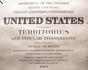
Department Of The Interior / General Land Office /./ United States / Department of the Interior / General Land Office / William A. Richards, Commissioner / United States / Including / Territories / and Insular Possessions / Showing the Extent of / Public Surveys, / Indian, Military and Forest Reservations, Railroads, Canals / / National Parks and Other Details / Compiled Under the Directions of / Frank Bond /./ 1904
Published by (Govt. Printing Office?); (Washington DC?); pp.; ; VG; nc/1904, 1904
Seller: Watermark West Rare Books, Wichita, KS, U.S.A.
Seller rating 4 out of 5 stars
Map
No Binding. Condition: Very Good. A huge, detailed wall-map of the United States and her territorial possessions._____ It is a single sheet, 60 x 83.5" (7 feet across!), mounted to linen(?)._____ Since the paper shows no fold lines, it is a roll-up wall map, as issued._____ EXTRA SHIPPING FEES WILL BE REQUIRED FOR THIS UNGAINLY OBJECT. _____ In the lower right corner."M. Hendges / Draughtsman" _____ Besides the great detail listed in the title, the various continental treaty acquisitions are separately bordered and overprinted with their former owners and dates of acquisition. _____ The overseas colonies are shown in inset maps across the bottom: Alaska (14 x 17"), Philippine Islands (14 x 10"), Tutuila Group of Samoa (5.5 x 8.5"), Hawaiian Islands ( 6 x 9"), Porto (sic) Rico (5.5 x 12.25") and Panama (9 x 9.5")._____ Each is overprinted with the year of acquisition and source._____ However, the Panama inset is not so overprinted though it was formally transferred to US control in May 1904, perhaps indicating this map went to the printer's early in that year._____ The bottom rod, with its ornate end-caps, is probably original._____ The top rod appears to be a piece of molding and is, almost certainly, a replacement. ______ There is cracking and chipping to the top 8" of the paper from rolling and storage._____ Easily the worst of it (2" pieces) is restricted to Canada.
-
Wall Map of Norfolk County, Massachusetts Based Upon the Trigonometrical Survey of the State.Inset maps of 'Plan of Dedham Village' and 'Plan of the City of Roxbury'
Published by Henry F. Walling, Boston, 1853
Seller: Yesterday's Gallery, ABAA, East Woodstock, CT, U.S.A.
Seller rating 5 out of 5 stars
26.8 inches high by 37 inches wide. Full hand color by town. Laid down on linen, rollers at top and bottom. Near Fine. Beautiful color.
-
Map of Gage County, Nebraska. From the records and actual surveys by Fred Gray
Published by Seevers & Gray (Milwaukee Litho. & Engraving Co.), NP [Beatrice, NB?], 1884
Seller: Bartleby's Books, ABAA, Chevy Chase, MD, U.S.A.
Association Member: ABAA ESA ILAB IOBA
Seller rating 5 out of 5 stars
First Edition
First edition (?). Lithographed wall map, 64 1/1 x 52 1/4 inches, the townships colored in shades of green, pink, and yellow; with street plans for the following towns in the margins: Liberty, Filley, Beatrice, Holmesville, Cortland, Odell, Barneston, Adams, Blue Springs, and Wymore. Not in Phillips. Not in the online Rumsey catalogue. Not recorded on OCLC. Backed with linen, some restoration along bottom edge, new rollers, new edge piping and ties. (2599).
-

Ranally physical-political North America.
Publication Date: 1949
Seller: Geographicus Rare Antique Maps, Brooklyn, NY, U.S.A.
Association Member: ABAA ESA ILAB
Seller rating 4 out of 5 stars
Map
Very good. Dissected and laid on linen. Some discoloration at top margin and top-left. Size 32 x 22.5 Inches. Here is a large-scale linen-backed folding wall map of North America produced by Rand McNally and Co. c. 1949. Both attractive and comprehensive, it combines political, topographical, and other information in a style characteristic of the 'Ranally' series produced in the mid-20th century. A Closer Look This is a versatile map in every sense. It can be folded onto itself and carried in one arm but also has grommets installed at the top corners for wall hanging. It includes a wide variety of information on political boundaries, cities, transportation, topography, and maritime navigation (a notable feature is the inclusion of ocean depths). Insets are provided at top-left and at bottom-right, respectively depicting the Aleutian Islands and Puerto Rico with the Lesser Antilles. The provinces of Canada and the states and territories of the U.S. and Mexico are indicated. The map employs Lambert azimuthal equal area projection, with a point of tangency located near Bismarck, North Dakota, at roughly the mid-point of the continent. This projection is especially well-suited to the mapping of hemispheres and continents (as opposed to the entire globe). Publication History and Census This map was produced by Rand-McNally in or around the year 1949, number 'RB100' in the Ranally series of the company's political-physical maps. It is only cataloged among the holdings of the University of Denver and Syracuse University, and is scarce to the market. References: OCLC 933302618.
-

Japan. Headline Focus Wall Map 11.
Publication Date: 1970
Seller: Geographicus Rare Antique Maps, Brooklyn, NY, U.S.A.
Association Member: ABAA ESA ILAB
Seller rating 4 out of 5 stars
Map
Very good. Exhibits wear along original fold lines and pinholing at top two corners. Verso repairs to fold separations and at fold intersections. Fold intersections exhibit slight loss. Blank on verso. Size 36.5 x 27.25 Inches. This is a 1970 Civic Education Service wall map of Japan celebrating that nation's meteoric recovery after World War II and the recently-opened Expo '70 world's fair outside Osaka. Japan's home islands, colored orange, are flanked by two blocks of text. The text block on the left applauds Japanese economic successes and their sensational rise 'up from the ashes' of World War II. When this map was printed, Japan had recently passed West Germany to become the world's third-strongest economic power. The photographs printed along the right reinforce Japan's economic power and highlight its auto industry, dressmaking schools, and its shipyards. Japan's generosity toward 'underdeveloped nations' is also promoted. The successful launch of a satellite into space, illustrated here by a rocket 'painted with red and white stripes like a barber's pole,' gained Japan entry into the exclusive 'Space Club' alongside the U.S., the Soviet Union, France, and Britain. Expo '70 Expo '70, held outside Osaka between March 15 and September 13, 1970, had 'Progress and Harmony for Mankind' as its central theme. The expo occupied 820 acres, and seventy-eight nations participated. An architect's drawing of the U.S. pavilion occupies the map's lower right corner. The U.S. pavilion, the second largest at the Expo (Japan's was the largest), had a roof that covered an area the size of two football fields. It housed, among other things, moon rocks gathered by Apollo XII astronauts and Babe Ruth's baseball uniform. Today, the site of Expo '70 is known as the Expo Commemoration Park, and, although many of the pavilions have been demolished, the Tower of the Sun still stands. Publication History and Census This map was created and published by the Civic Education Service as Volume 7, Number 11, on March 16, 1970. This is the only known example.
-

Secession 1860-1861.
Publication Date: 1940
Seller: Geographicus Rare Antique Maps, Brooklyn, NY, U.S.A.
Association Member: ABAA ESA ILAB
Seller rating 4 out of 5 stars
Map
Very good. Backed on linen. Attached to original rollers. Measurment is for the map itself. Since the map is attached to rods, they add an another 2 inches in height and 3.5 inches in width. Size 30.5 x 43.5 Inches. This is a c. 1940s Albert Bushnell Hart and Denoyer-Geppert Company wall map of the United States. The map depicts the continental United States from the Pacific Ocean to the Atlantic Ocean and from Canada (labeled British Possessions) to Mexico. The states are shaded multiple different colors to differentiate between the states and territories that remained in the Union and those that seceded. The two different colors employed to denote the states that seceded are divided in two: those that seceded before April 14, 1861 and those that seceded after. Fort Sumter, a U.S. Army fort in Charleston Harbor, surrendered April 14, 1861, and President Lincoln issued a proclamation calling up 75,000 troops to put down the rebellion. For four states, Arkansas, Tennessee, North Carolina, and Virginia, this was the act that pushed them into joining the Confederacy. Missouri, Kentucky, Maryland, and Delaware which are shaded green, were slave states that never declared secession. West Virginia, joined the Union in 1863, when it seceded from Virginia. Several notations on the map refer to the state of war between the Confederate States of America and the United States of America. Forts are depicted and are labeled by which side held which fort. A handful of arsenals and navy yards are also included. An inset map of Charleston Harbor is located along the bottom border next to the key. Regarding the general geography of the map, the state capitals and other major cities are labeled, along with rivers and the Great Lakes. This map was created by Albert Bushnell Hart with L. Philip Denoyer serving as geographer. The map was compiled and drawn by R. Baxter Blair and published by the Denoyer-Geppert Company of Chicago. It is number A15 in the Denoyer-Geppert Social Science map series. We have dated this map as c. 1940s due to the paper it is printed on. Several different editions of this map were printed, which allows for the possibility that this particular example could date from an earlier or later year.
-

Walt Disney's Disneyland.
Publication Date: 1979
Seller: Geographicus Rare Antique Maps, Brooklyn, NY, U.S.A.
Association Member: ABAA ESA ILAB
Seller rating 4 out of 5 stars
Map
Good. Wear along original fold lines. Slight loss at a handful of fold intersections. Fold wear. Size 28 x 43 Inches. This is a 1979 Walt Disney Productions pictorial wall map of Disneyland. It was published shortly after the opening of 'Big Thunder Mountain', still one of the park's most beloved rides. The railroad and the monorail both grab attention. The whole is surrounded by a border of Disney characters: Mickey Mouse, Donald Duck, Minnie Mouse, Alice from Alice in Wonderland, Peter Pan, Dumbo, and Bambi. Publication History and Census This map was published by Walt Disney Productions in 1979. References: OCLC 772514929, 953572516.
-

1957 Europa Witschaft & Verkehr
Seller: New World Cartographic, Chicago, IL, U.S.A.
Seller rating 4 out of 5 stars
Map
By: Georg WestermannDate: 1957 (circa) GermanyDimensions: 46 x 36 inches (116.8 x 91.4 cm)This superb, fun, pictorial wall map by Georg Westermann depicts the same area of the world as does his 'Europa Kultur' map, this time with a focus on industry.The map covers Europe in its entirety, extending southward to include northern Africa, westward beyond the British Isles, eastward to include portions of Russia, and northward towards the arctic circle. Here the basic industries of each region of Europe are portrayed by easily recognizable iconographic images, as are the bounteous natural resources. Myriad species of flora and fauna are represented with such images as luscious looking grapes on the vine, fruit of different varieties, fish inhabiting the waterways, seas and oceans, and the fishing industry is depicted in its old-fashioned manner, long before the at-sea factories which harvest and pillage the seas had been devised.As are all great river systems in Westermann's maps, those of Europe are accentuated. Symbols for elements in the periodic table denote natural resources which are found in various regions including gold, silver, copper, zinc, lead and iron to name a few. Agriculture is well represented with cattle, sheep, camels in Africa and myriad crops throughout the countries depicted. Shipping and water sports are featured, as are the oil, cotton and timber industries.Condition: This map is in B+ condition with one hole approximately the size of half a dime in the upper right quadrant. The dowels are in excellent condition, and the self-tie is intact.Inventory #110991200 W. 35th Street #425 Chicago, IL 60609 | P: (312) 496 - 3622.
-

Cooperative Map of Glacier National Park and Portions of the Kootenai, Lewis and Clark, and Flathead National Forests.
Publication Date: 1935
Seller: Geographicus Rare Antique Maps, Brooklyn, NY, U.S.A.
Association Member: ABAA ESA ILAB
Seller rating 4 out of 5 stars
Map
Very good. Light wear along original fold lines. Closed minor margin tears professionally repaired on verso. Size 36.25 x 44 Inches. This is a 1935 U.S. Forest Service and National Park Service wall map of Glacier National Park and its immediate surroundings. Glaciers, mountain peaks, waterfalls, and other landmarks are identified throughout Glacier National Park and the surrounding forests. Campgrounds are marked by small tent icons and labeled. Contour lines present the park's impressive topography and mountain lakes and rivers are illustrated. Glacier National Park Glacier National Park, established May 11, 1910, is an American national park in northwestern Montana on the U.S.-Canada border. Encompassing over one million acres, Glacier National Park includes part of two sub-ranges of the Rocky Mountains and is home to hundreds of species of animals. 130 named lakes are within the park's borders. The park also borders Waterton Lakes National Park in Canada which led to the establishment of Waterton-Glacier International Peace Park in 1932. The Peace Park was named a UNESCO World Heritage Site in 1995. Publication History and Census This map was jointly compiled and published by the U.S. Forest Service and the National Park Service in 1935. We note four examples cataloged in OCLC which are part of the collections at the University of Idaho, Washington State University, Reed College, and the University of California Berkeley. An earlier edition was published in 1929. Only one example of the 1929 edition is cataloged in OCLC, and it is part of the collection at the University of Montana. References: OCLC 38112305.
-
/ [Africa].
Publication Date: 1952
Seller: Geographicus Rare Antique Maps, Brooklyn, NY, U.S.A.
Association Member: ABAA ESA ILAB
Seller rating 4 out of 5 stars
Map
Very good. Closed margin tears professionally repaired on verso. Area of reinforcement on verso off the coast of Nigeria. Size 35.25 x 41.25 Inches. This is a c. 1952 Russian Cold War-era wall map of Africa. Dating from the beginning of the age of decolonization, color explain complex colonial claims. Pink marks French territory in West Africa and Madagascar, while green illustrates British territory. Anglo-Egyptian Sudan is filled with green and tan stripes, underlining the 'power-sharing' agreement in then effect. A golden color highlights Portuguese holdings in modern-day Angola and Mozambique. Black dashed lines mark railroads and bright red lines trace highways. Africa and Decolonization After the 1885-85 Berlin Conference resulted in the 'General Act of the Berlin Conference', European powers officially partitioned Africa between themselves, placing no value on the claims and priorities of the indigenous peoples. Over the ensuing sixty to eighty years, African peoples chafed under European rule and were exasperated by their claims that national self determination did not apply to the colonized. After the end of World War II, colonized Africans began to take measures into their own hands and push for independence. An uprising in Algeria was violently suppressed by the French just days after the end of World War II (1939 - 1945) in Europe. Native Kenyans began the violent Mau Mau Uprising against the British in the early 1950s, around the time this map was published. A war between the Algerians and the French erupted later in the 1950s and several other bloody conflicts and civil wars started across the continent in the subsequent decades. The Cold War and Proxy Wars Unfortunately for the Africans, their continent also became fertile ground for proxy wars between the United States and the Soviet Union during the Cold War (1947 - 1989). Both powers believed that a key to winning the Cold War was amassing allies and spheres of influence worldwide. This meant gaining favor in the Third World, and through influence and monetary support for one leader or another these goals were achieved. However, this desire for influence led to the opposition funding armed uprisings against regimes that supported the other side, be they pro-American or pro-Soviet. Publication History and Census Although this map is both undated and unsigned (which is very peculiar for a Soviet-era map), we believe that it was likely created and published by the Main Directorate of Geodesy and Cartography under the Council of Ministers of the U.S.S.R. around 1952 due to the similarities between this piece and a map of North America published by this organization in 1952. We have been unable to locate any other cataloged examples.


![Seller image for / [Africa]. for sale by Geographicus Rare Antique Maps](https://pictures.abebooks.com/inventory/md/md32068516163.jpg)