World War Ii Map (73 results)
 More images
Published by War Hospitality Committee, Washington DC, 1943
- Hardcover
- First Edition
Seller: The First Edition Rare Books, LLC, Cincinnati, OH, U.S.A.The First Edition Rare Books, LLC
Contact seller5-star sellerCondition: Used - Very good
US$ 475.00
US$ 6.00 shippingShips within U.S.A.Quantity: 1 available
Pamphlet. Condition: Very good. First Edition. Folded color map, measures 4" x 7.5" folded and 16.25" x 14.75" fully opened. Contains printed text identifying various points of interest in the Washington DC area with a corresponding color-coded map on verso. Stated "correct as of April 30, 1943" along bottom edge. Near fine with… some mild overall toning and light wear along folds. Two ink marks on verso, no impact to map. One hinge separated at fold. A scarce work, with only two similar maps located in OCLC (Stanford University with a 1944 printing and the Library of Congress with an earlier 1943 printing). A nice piece of WWII home front history. This map of 1940s Washington DC provided travel information specific to the needs of visiting members of the armed forces. Included are places of lodging, sightseeing, entertainment and religious worship. Some facilities listed in the text are highlighted as "Service Women Welcome." Still others, particularly USO clubs, YMCAs and churches, are marked "Negro," illustrating the segregation that existed at the time. Service Men's Map of Washington from the War Hospitality Committee, being a guide for military personnel visiting Washington DC during World War II. (illustrator).

Seller: Books 4 People, Leicester, LEI, United KingdomBooks 4 People
Contact seller5-star sellerCondition: Used
US$ 41.12
US$ 33.37 shippingShips from United Kingdom to U.S.A.Quantity: Over 20 available
 More images
Published by Army Orientation Course. / News Map of the Week, Inc. 13 April1942., 1942
Seller: Asia Bookroom ANZAAB/ILAB, Canberra, ACT, AustraliaAsia Bookroom ANZAAB/ILAB
Contact seller5-star sellerCondition: Used
US$ 89.34
US$ 21.25 shippingShips from Australia to U.S.A.Quantity: 1 available
Volume 4, No. 32. Folding colour pictorial map on sheet 88 x 119 cms, (blank on verso), inset maps (two photographic), diagrams and black and white photographic illustrations, descriptive text, top edge chipped, a few short edge tears and lower corner torn (no loss), pinholes at the corners, inoffensive tidemark at a lower corne…r, in good condition. Colour world map showing political boundaries and military events of World War II, from April 3 to 9, 1942. with descriptive text beneath including: the loss of two British Cruisers off Ceylon; the occupation of Bataan by the Japanese and their landing on Manus; Japanese war tactics revealed by Malay prisoners and the increasing importance of Central Africa to the Allied war effort. The. Map is indexed according to these notes. Two inset maps of Europe chart Hitler's gains in 1941 and activity on the Russian Front. Additional diagrams on the main world map show war spending and the civilian and war output of US industries.
Published by Hutchinson & Co. (Circa1940)., London., 1940
Seller: Asia Bookroom ANZAAB/ILAB, Canberra, ACT, AustraliaAsia Bookroom ANZAAB/ILAB
Contact seller5-star sellerCondition: Used
US$ 89.34
US$ 21.25 shippingShips from Australia to U.S.A.Quantity: 1 available
Full colour folding map, 70.7 x 93 cms; 76 x 101.2 cms (sheet), original folds, short fold splits, previous owner's neat title markings on the verso, but the map in very good condition. A "Geographia" map of the war theatre in Asia and the Pacific including the northernmost coast of Australia. Showing railways and canals, roads…and steamer routes, oilfields and pipe lines and a key to the unfederated states of Malaya. The Spratley Islands are marked as French and Thai territorial claims within French Indo China are marked.

Published by ???(Tosei-sha) ??18 [Showa]1943., Tokyo, 1943
Seller: Asia Bookroom ANZAAB/ILAB, Canberra, ACT, AustraliaAsia Bookroom ANZAAB/ILAB
Contact seller5-star sellerCondition: Used
US$ 142.95
US$ 21.25 shippingShips from Australia to U.S.A.Quantity: 1 available
Folding colour map of New Zealand with inset of Auckland and Wellington top and bottom corners,1:2,000,000 scale, little light browning. Original envelope worn with closed tears. 54 x 76.5cm. Good copy. Scale plan of New Zealand printed by Tosei in 1943. The map legend shows infrastructure deemed important to the Land Survey Bur…eau of the General Staff Headquaters of the Imperial Japanese army, such as boundaries, powerlines, quarries and mines; railroads, sea-routes, etc.

Published by ???. [Seibunkan]. Circa1942., ??. [Tokyo]., 1942
Seller: Asia Bookroom ANZAAB/ILAB, Canberra, ACT, AustraliaAsia Bookroom ANZAAB/ILAB
Contact seller5-star sellerCondition: Used
US$ 210.85
US$ 21.25 shippingShips from Australia to U.S.A.Quantity: 1 available
Colour map, 75 x 110cm, folds to 28 x 19cm. Some light browning, somewhat heavier along a few folds. A good copy. This map, which was most likely published around 1942 or 1943, depicts the world during the global conflict. Japan is positioned in the centre, and its territories are coloured in red. In Southeast Asia, Japanese-occ…upied areas, including Singapore, the Philippines, and the Dutch East Indies, are marked with red. Two inset maps display Europe and the Japanese-occupied area to the south as the "Southern Co-Prosperity Sphere." The map is folded to 28 x 19 cm, and its cover features the national flags of Japan, Nazi Germany, Italy, the Soviet Union, Britain, and the United States, arranged artistically.
 More images
Published by George Philip & Son., London., 1944
Seller: Asia Bookroom ANZAAB/ILAB, Canberra, ACT, AustraliaAsia Bookroom ANZAAB/ILAB
Contact seller5-star sellerCondition: Used
US$ 232.29
US$ 21.25 shippingShips from Australia to U.S.A.Quantity: 1 available
Full colour folding map, 101.5 x 76cm (sheet), inset maps, legend, folding into title wrapper 25.7 x 19.4 cms, covers a little dusty and discoloured, a few short fold splits (without loss), but the map in very good, bright condition. Map of the Pacific Theatre of World War II, with borders drawn as they stood in 1937 - complete…with Chinese claims on Mongolia, Tuva and Tibet. Shows transportation routes, principal railways, oil fields, Allied naval bases, territory occupied by the British Empire, French Empire and the United States. This map shows only the northernmost section of Australia which allows for much better detail of the countries of East Asia. Small inset map of the Hawaiin Islands at mid right. Inset map of the Pacific Ocean at upper left.
 More images
Published by Army Information Branch., New York., 1944
Seller: Asia Bookroom ANZAAB/ILAB, Canberra, ACT, AustraliaAsia Bookroom ANZAAB/ILAB
Contact seller5-star sellerCondition: Used
US$ 250.16
US$ 21.25 shippingShips from Australia to U.S.A.Quantity: 1 available
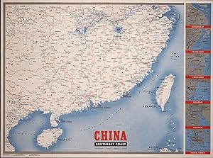
Very large folding colour map, main map 85 x 95.5 cm plus 6 sidebar maps, together 85 x 14.1 cms; sheet 88 x 118 cms, and on the verso a large circular map centred on Europe (the Ruhr Valley & Vienna) with smaller maps of Southeast Asia and the Philippines and a map of Okinawa; both in very good unblemished condition. The main m…ap of Southeast China includes inset maps of the region around Shanghai, Wenchow, Foochow, Swatow, Canton and Hong Kong and on the verso text as well as the maps (Eastern Europe, South Pacific, Okinawa) reporting on the war: Americans Isolate Ruhr; Vienna Threatened; Ryukyus Invaded.

Published by Army Information Branch., New York., 1944
Seller: Asia Bookroom ANZAAB/ILAB, Canberra, ACT, AustraliaAsia Bookroom ANZAAB/ILAB
Contact seller5-star sellerCondition: Used
US$ 250.16
US$ 21.25 shippingShips from Australia to U.S.A.Quantity: 1 available
Very large folding colour map, main map 85 x 95.5 cm plus 6 sidebar maps, together 85 x 14.1 cms; sheet 88 x 118 cms, several fold splits (archivally sealed), in good condition. Large colour wartime map issued by the U.S. Army Information Branch in 1944, the main map showing Shanghai to French Indochina, with the islands of Form…osa and Hainan (scale 7 inches to 200 miles). At the right edge are inset maps of Shanghai, Wenchow, Foochow, Swatow, Canton, and Hong Kong. Map issued to accompany Newsmap (Volume III, No. 51B).

Published by H.E.C. Robinson Pty. Ltd. circa1940., Sydney., 1940
Seller: Asia Bookroom ANZAAB/ILAB, Canberra, ACT, AustraliaAsia Bookroom ANZAAB/ILAB
Contact seller5-star sellerCondition: Used
US$ 250.16
US$ 21.25 shippingShips from Australia to U.S.A.Quantity: 1 available
Full colour folding map, 71 x 97 cms; 76.2 x 10² cms (sheet), blank on verso, save for a neat inked stamp "East Indies", inset map of New Guinea and Papua, heights shown by colour, very good, clean condition. Large scale World War II era map by Sydney publisher H. E. C. Robinson. Extremely detailed map, it is coloured according…to height above sea level and showing naval bases, railways, shipping routes, air routes. Includes smaller inset map of "New Guinea & Papua" showing the eastern part of the island.
 More images
Published by Army Service Forces, War Dep't. 4 September,1944., New York., 1944
Seller: Asia Bookroom ANZAAB/ILAB, Canberra, ACT, AustraliaAsia Bookroom ANZAAB/ILAB
Contact seller5-star sellerCondition: Used
US$ 250.16
US$ 21.25 shippingShips from Australia to U.S.A.Quantity: 1 available
Large folding colour map 83.3 x 110 cms; 87.5 x 119 cms (sheet), folding to 22 x 29.5 cms, related text, maps and a black and white photographic illustration on the verso, small central fold split, in very good bright condition. Very atttractive full sheet aerial physical 3-D type map of Celebes (Sulawesi) and adjacent islands.…On the verso are text updates on the U.S and Allied war fronts: North France (the re-capture of Paris), South France, Italy, Pacific and the Eastern Front. Accompanying the text are maps of Northen France, with an inset map of Paris, an "oblique view of southern France looking north up the Rhone River Valley," the Balkans, and a large black and white photographic aerial view in Italy showing supplies ready for loading onto aircraft prior to the landings in southern France.
 More images
Published by Chicago Daily Tribune. 28 July1945., Chicago., 1945
Seller: Asia Bookroom ANZAAB/ILAB, Canberra, ACT, AustraliaAsia Bookroom ANZAAB/ILAB
Contact seller5-star sellerCondition: Used
US$ 282.32
US$ 21.25 shippingShips from Australia to U.S.A.Quantity: 1 available
Colour bird's eye view map, 22.4 x 39.3 cms on a newspaper leaf trimmed to a half sheet 29.8 x 41.6 cms (including caption), slight toning at an old central fold, the map in very good condition. Unrelated black and white photographic illustrations on the verso "Pre-flight Trainers used in Chicago to give ground instruction to wo…uld-be pilots" and "New rekindled Montauk Light, Long Island, N.Y." Map published in the Chicago Daily Tribune days before the bombing of Hiroshima on August 6,1945. "Perspective map of Tokyo bay and contiguous land and sea areas, showing Tokyo, Yokohama, the Yokosuka naval base, industrial sections and other features .In this map north is at the right instead of at the top - an expedient adopted to show all of the bay as large as possible in half page space." (caption).
 More images
[Latest Detailed Map of China].
1937 Fuchida Tadayoshi Map of China; Second Sino-Japanese War, World War II
- Softcover
- Map
Seller: Geographicus Rare Antique Maps, Brooklyn, NY, U.S.A.Geographicus Rare Antique Maps
Contact seller4-star sellerSoft cover. Average. Wear and loss along fold lines. Wormholes at bottom-left. Periodic foxing. Size 31 x 21.5 Inches. This is a 1937 Fuchida Tadayoshi map of China published in King (???) magazine during the opening phase of the Second Sino-Japanese War (World War II). A Closer Look Between the front (recto) and back (verso), t…he map shows the entire front of the early phase of the conflict, from Japanese puppet states in Manchuria and northern China to China's southern coastal provinces of Fujian and Guangdong. At front is the coastal regions of northern China, roughly as far as Shanghai, where Japanese influence was already strong after years of expanding its military and economic presence. The level of detail is extraordinary, particularly for a popular publication, but also highlights the immensity of the task facing Japan if it intended to occupy all of China. It is worth noting that, at the time of publication, it was not clear that the hostilities in China would evolve into a full-scale, protracted war. Japan initially hoped for more Chinese concessions and piecemeal territorial gains, and later aimed to deliver a severe enough blow to force Chiang to surrender. Full mobilization on a total war basis only commenced the following year, when it became clear that Chiang and his troops had no intention of surrendering despite losing Shanghai, Nanjing, and much else. Verso Content The back (verso) includes two larger maps, a wider perspective of eastern China and a map of central China from Shanghai southwards, respectively. The inset maps are, starting at top-right and moving clockwise, Beiping (Beijing), Tianjin, Qingdao, Guangdong (Guangzhou), Hong Kong, Wuhan (Hankou, Wuchang, and Hanyang), Jinan, Shanghai, and Nanjing. The Battle for Shanghai and Its Aftermath Starting with the Japanese invasion of Manchuria (the 'Mukden Incident') in September 1931, Chinese and Japanese troops fought on-again, off-again battles in northern China for several years. One of these many skirmishes took place on July 7, 1937, at the 'Marco Polo Bridge' (Lugouwiao ???), just to the southwest of Beijing. Chiang Kai-Shek was reluctant to throw his armies into a full-scale war against the better trained and equipped Japanese forces, but was compelled to bow to public pressure and launch the long-expected war. Chiang decided to dedicate the bulk of his best trained and equipped forces to a battle for Shanghai, allowing Beijing (at this time Beiping) to fall along with the rest of coastal north China, which was already within Japan's sphere of influence and virtually impossible to defend. Chiang also decided to focus on Shanghai because of the city's international profile and the large numbers of foreigners there; his strategy for winning the war relied in part on gaining foreign support, which ultimately succeeded. Due to the speed and surprise of their attack, Chinese troops at first succeeded in seizing territory defended by Japanese garrison forces in Shanghai, but lost momentum as Japanese reinforcements and heavy weapons came into play. Chinese-administered parts of the city, particularly Zhabei and Wusong to the north and east of the International Settlement, along with the Japanese neighborhood of Hongkou in the International Settlement, saw extensive bombardment and house-to-house fighting. Despite the valiant efforts of Chinese troops, Japanese forces had naval, air, and artillery superiority and were able to receive sufficient resupply and reinforcements, gradually turning the tide over several months. With most Chinese forces engaged in and around the city, a massive pincer counter-attack was prepared, similar to the Soviet victory at Stalingrad six years later. Severely weakened by the fighting in Shanghai and with many units in disarray, Chiang arranged a hasty defense of Nanjing while planning for a retreat to Chongqing, deep in the Chinese interior, to prepare for a long-term war of attrition. King Magazine and Ko?dansha King (???) was a mont.

Published by Australian Motorists Petrol Company Ltd. (A.M.P.) pre1942., Sydney, Australia., 1942
Seller: Asia Bookroom ANZAAB/ILAB, Canberra, ACT, AustraliaAsia Bookroom ANZAAB/ILAB
Contact seller5-star sellerCondition: Used
US$ 321.63
US$ 21.25 shippingShips from Australia to U.S.A.Quantity: 1 available
Large brightly coloured folding world map 51 x 97.4 cms (map); 61 x 101 cms (sheet), archivally mounted on linen, breaks at several folds and a minute bit of paper loss in the Celebes (now Sulawesi) and northern Afghanistan professionally repaired; in very good clean condition. World War II era advertising wall map printed in Au…stralia for Australian Motorists Petrol Company Ltd. (AMP, now Ampol): "With the Compliments of Australian Motorists Petrol Co. Ltd. (Authorized Capital £1,000,000)" (map text) and pleads "In Wartime buy Australian" and "Australia Merits Preference". AMP was the first publicly listed Australian oil company. A colour-coded key identifies European colonial powers, the continent of Africa being the recipient of multiple colonial claimants. British Imperial might was still dominant however, claiming Australia, New Zealand, Canada, Southern and Eastern Africa, India, and British Guyana. Notably Micronesia is identified as "Japanese Mandate", but the map was published before the Japanese occupation of New Guinea. Tannu Tuva (now the Tuva Republic within the Russian Federation) is noted separately as is Sinkiang (now Xinjiang Uyghur Autonomous Region [XUAR]). A scarce map and when available usually in poor condition, this copy in very good, attractive condition archivally mounted and ready for framing.

Published by Shin'aichi, Nagoya, 1939
Seller: Kay Craddock - Antiquarian Bookseller, Melbourne, VIC, AustraliaKay Craddock - Antiquarian Bookseller
Contact seller5-star sellerCondition: Used
US$ 321.63
US$ 26.00 shippingShips from Australia to U.S.A.Quantity: 1 available
Coloured folded map of Europe published at the beginning of World War II in Europe; 38.5 cm. x 54 cm.; a few tiny closed tears at margins; Shin'aichi, Nagoya, n.d.[1939]. *The Japanese text on the map gives numbers of Europe's ethnic groups: Teutonic, Latin, Slav, Asian, while another block of text lists the population of the wo…rld's Jews, in units of 10,000 by country. The world population by region, in units of 100,000,000 and those of the world's ethnic groups are shown to the left. In the upper right corner facts about World War I are given including number of troops by country, in units of 10,000. A legend shows national borders prior to World War I, railways, navigable rivers, etc. Neutral powers are indicated, together with naval bases, place names in international dispute, etc.; [Originally purchased from Asia Bookroom, the basis of whose catalogue description is used here].

- Softcover
- Map
Seller: Geographicus Rare Antique Maps, Brooklyn, NY, U.S.A.Geographicus Rare Antique Maps
Contact seller4-star sellerSoft cover. Very good. Exhibits minor wear along original fold lines and a few verso reinforcements. Bears collection stamp from the Ashtabula Public Library in Ohio on verso. We have contacted the library and confirmed that it was legally deaccessioned. Size 43 x 34 Inches. Published during the 1944 World War II Red Army offens…ives on the Eastern Front, this 1944 Robert M. Chapin Jr. map of Romania, Bulgaria, and Ukraine emphasizes Soviet gains in the region. Red arrows, indicating Soviet troops, push south forcing white arrows, representing Axis forces, to retreat. Major cities, including Odessa, Lwów (now Lviv, Ukraine), Bucharest, and Sofia, stand in the Red Army's path. This map was produced to illustrate an article lauding the Red Army's impressive drive across Ukraine. Publication History and Census This map was drawn by Robert M. Chapin Jr. and published in the April 3, 1944 issue of TIME Magazine. One example is cataloged in OCLC and is part of the collection at Franklin and Marshall College. References: OCLC 81534009.

Published by Second Armored Division, Germany?, 1945
- Map
Seller: Hoffman Books, ABAA, IOBA, Columbus, OH, U.S.A.Hoffman Books, ABAA, IOBA
Contact seller3-star sellerCondition: Used - Very good
US$ 350.00
US$ 8.00 shippingShips within U.S.A.Quantity: 1 available
Original Vintage Map. Condition: Very Good. 29 x 42 inch original vintage map produced by the U.S. Military titled "Hell on Wheels War Against the Axis, 1942-1943-1944-1945" detailing the route and battles of the 2nd Armored Division as they worked their way from France through Belgium and into Germany in World War II. This is t…he larger version of a map which was issued the previous year. The map shows general handling wear and some edge chipping. There is a small (mostly closed) tear in the lower left quadrant. Included with the map is the original heavy mailing tube which shows it was sent by a Private Anderson (APO New York) to his family in Quinnimont, Fayette, County, West Virginia. The map appears to be scarce in the trade with only 1 original currently listed for sale online (vialibri). An example is listed and shown at David Rumsey's map website. We are offering this vintage World War II map with its original mailing tube. OCLC offers this note: "Shows route of 2nd Armored Division from Littry, France, to Gutergluck, Germany, with historical notes for selected locations. Includes brief history of the 2nd Armored Division. Marginal information includes place names, military insignia, and names of military divisions. Passed for press duplication by A.E.F. Field Press Censor.".
 More images
Newsmap for the Armed Forces. 291st Week of the War - 173rd Week of U.S. Participation. Monday, 9 April, 1945.
[CHINA - MAP - WORLD WAR II].
Published by Army Information Branch. 9 April1945., New York., 1945
Seller: Asia Bookroom ANZAAB/ILAB, Canberra, ACT, AustraliaAsia Bookroom ANZAAB/ILAB
Contact seller5-star sellerCondition: Used
US$ 357.37
US$ 21.25 shippingShips from Australia to U.S.A.Quantity: 1 available
Volume III, No. 51F. Folding colour map and six inset maps in a vertical panel, 88 x 119 cms (sheet) and (on the recto) circular map of Europe, smaller inset map of Asia and of the Ryukyu Islands, descriptive text, original folds, in very good, bright condition. Scarce Newsmap of "China Southeast Coast" from Shanghai to French I…ndochina, with the islands of Formosa and Hainan. At the right edge are inset maps of the vicinities of Shanghai, Wenchow, Foochow, Swatow, Canton, and Hong Kong. On the verso is a large map of the European theatre of operations, centred on Berlin, a map of the Pacific area noting the American occupation of Okinawa with a detailed map of this island. In unusually fine, bright condition.
Published by American Forces Pacific, General Headquarters, United States Army, Nippon Map Co. [Nihon Chizu Kabushiki Kaisha], Feb., 1946., Tokyo, Japan:, 1946
- First Edition
Seller: Zephyr Used & Rare Books, Vancouver, WA, U.S.A.Zephyr Used & Rare Books
Contact seller5-star sellerOblong double atlas folio map, printed on recto in 5 colours sized 30.25 x 41.75 in., including margins, title panel w pictorial map for when folded showing "Bombed-out Areas" in miniature, large regional map printed in green (minor age toning, some minor thumbing, shelfwear, rubbing, a couple very slight closed tears at fold cr…eases), still a VG bright copy. First edition of this startling map prepared from a Japanese Tokyo City map revealing the tremendous extent of damage created during the B-29 bomber bombing campaigns by the Allies in 1945, including Feb. 24-25 when 174 bombers dropped incendiary bombs destroying 1.5 square miles of the city and 28,000 buildings; March 9-10 when 279 bombers destroyed 267,000 buildings over 41 square miles; as well as the massive air raids of April 26 with 464 B-29 Bombers attacking urban areas south of the Imperial Palace, and May 24, when another 520 bombers attacked leaving swathes of the city in ruins. The splashes of yellow-gold vividly portray the bombed portions, and green lines the fire breaks created from demolishing swathes of houses, office buildings, and apartments in the city to stop the fires burning. These maps were released solely for occupation and reconstruction forces of the Allies after Japan's surrender, and were not intended "For sale or distribution." Worldcat locates 7 copies (U of CO, U of GA, U of Chicago, Harvard, U of MN, U of WI, NL Australia).
 More images
Published by C.C. Petersen., Toronto., 1944
Seller: Asia Bookroom ANZAAB/ILAB, Canberra, ACT, AustraliaAsia Bookroom ANZAAB/ILAB
Contact seller5-star sellerCondition: Used
US$ 393.11
US$ 21.25 shippingShips from Australia to U.S.A.Quantity: 1 available
Colour pictorial map, 51 x 67 cms, two small inset maps of Scandinavia and the Baltic and South Greece and the Dodecanese, on the verso a black and white world map showing the Pacific Theatre marking keys events of the war and in European world history, folding into the original pictorial pocket (a little toned and marked) 25.8…x 17.7 cms, small fold split, but in very good condition. A scarce map in the "Dated Events" series published by C.C. Petersen in Canada, and distributed throughout North America commemorating D-Day. The colour map by Stanley Turner encompasses the area from England as far south as the French border with Spain and as far east as the USSR and Turkey. "With this invasion map you will be able to follow the progress of the Allied troops on their way to smash Germany.". The text at lower left goes on to elaborate on the features shown on the map, from elevation ("major battles are seldom fought on the tops of mountains") to pictographs of bombs falling. The black and white map on the verso shows the Far Eastern theatre of war, centring on the Pacific Ocean with the Asian landmass including India and the USSR at upper left, Australia at lower left and North America and the coast of South America at right of the map. Naval bases are shown and significant events in the war are noted in text boxes. A handsome production of a scarce map rarely seen with the original pictorial pocket.
 More images
??????????????. [Hit? oyobi Higashi Indo Shot? h?men senkyoku y?zu]. [Japanese Campaign Map of the Philippines and Dutch East Indies Areas].
[WORLD WAR II MAP OF SOUTHEAST ASIA WITH SINGAPORE PLAN INSET].
Published by [Japan]., 1942
Seller: Asia Bookroom ANZAAB/ILAB, Canberra, ACT, AustraliaAsia Bookroom ANZAAB/ILAB
Contact seller5-star sellerCondition: Used
US$ 393.11
US$ 21.25 shippingShips from Australia to U.S.A.Quantity: 1 available
Colour map, 21 x 50.5 cm, centrefold as issued. Faint dampstain to upper edge, centrefold a little browned. Good copy. Map of Southeast Asia, including Borneo and the Philippines and New Guinea. Of particular interest is the small inset map of Singapore at lower left. The war situation of the Japanese army in 1941 and 1942 durin…g the Pacific War is clearly shown with one sheet. Text in the inset plan of Singapore says "Occupation of Singapore in February 15 (1942)".

[Complete Map of the Hankou War Situation].
1938 Map of the Battle of Hankou (Wuhan), China; Second Sino-Japanese War, World War II
- Hardcover
- Map
Seller: Geographicus Rare Antique Maps, Brooklyn, NY, U.S.A.Geographicus Rare Antique Maps
Contact seller4-star sellerHardcover. Very good. Some dampstaining along fold lines. Small spot of loss at fold intersection. Size 21.5 x 15.5 Inches. This is a 1938 map of the Battle of Wuhan in the Second Sino-Japanese War (1937 - 1945) theater of World War II (1939 - 1945). It was published for the Japanese news daily, the Osaka Mainichi Shimbun . It c…overs much of central and southern China, particularly near the Yangtze River, in great detail; the battle raged over this area for much of the summer and autumn of 1938, resulting in a pyrrhic Japanese victory. A Closer Look at the Map This map shows the terrain of the Battle of Hankou (??; Hankow in contemporary sources, now part of Wuhan). Despite the name of the battle, it was in fact a wide-ranging campaign that spilled far beyond the city (at left-center), covering portions of six Chinese provinces. The map is extremely detailed, providing the names of a sea of small towns and villages. Just prior to the battle, Japan had entered a total war footing with the National Mobilization Law and called up conscripts. A home audience, especially those with family members at the front, would have been anxious to follow recent developments and have some sense of the places mentioned in the (tightly censored) news. The legend shows political boundaries, roads, railways (complete and under construction), and major cities. An inset map (1 : 8500000) shows the southern Chinese coast, including Hong Kong and the French Concession of Guangzhouwan marked out with dotted lines. After Japanese troops seized Guangzhou and other coastal cities, these territories and the Kunming-Haiphong Railway became essential routes for smuggling supplies to Chinese forces. The Second Sino-Japanese War The Second Sino-Japanese War was fought between the Republic of China, led by Chiang Kai-shek and the Guomindang (GMD, or Kuomintang KMT), and the Empire of Japan. Some scholars trace the beginning of the Second Sino-Japanese War to the Mukden Incident and the September 1931 Japanese invasion of Manchuria. In the following years, Japan established a puppet regime in Manchuria and extended its influence into northern China through several other 'incidents,' to the extent that it directly or indirectly controlled much of northern China and Inner Mongolia by 1937. Although determined to resist the Japanese, Chiang was eager to eliminate the domestic threat from the Communists first while also buying time to modernize his armies and gain better control over his generals, most of whom were semi-independent warlords. These plans were disrupted when Chiang was kidnapped by one of his own generals in December 1936 and forced to enter a united front with the Communists. Now compelled to turn his attention towards Japan, it was a matter not of if but when a war would come. The July 7, 1937 Marco Polo Bridge Incident has traditionally been considered the start of the war, when Chinese and Japanese troops began exchanging fire at the Marco Polo (Lugou) Bridge, along a main access route to Beijing. This exchange of fire escalated to an all-out battle leading to Japanese forces capturing both Beijing and its port city of Tianjin. As the conflict expanded, Chiang aimed to deliver a knockout blow before Japanese reserves could be thrown into the fight. He launched an assault on Shanghai in the autumn of 1937, hoping to throw the Japanese garrison there into the sea, but was unable to completely drive them out. When Japanese reinforcements did arrive, they launched a counterattack that forced Chiang to retreat from Shanghai with heavy losses. After a cursory defense of the capital, Nanjing, Chiang moved deep into the Chinese interior to prepare for a protracted war of attrition. Battle of Wuhan After their rapid victories at the start of the war, Japan was at an impasse. Years of military modernization and propaganda had laid the groundwork for the successful first phase of the war, but Japan simply lacked the resources and manpower to occupy the vast territory o.

Pictorial Review. How Japan's Mongol Hordes Can Be Defeated.
1943 Lord Pictorial Map of East Asia and Southwest Pacific during World War II
- Softcover
- Map
Seller: Geographicus Rare Antique Maps, Brooklyn, NY, U.S.A.Geographicus Rare Antique Maps
Contact seller4-star sellerSoft cover. Very good. Newsprint. Closed margin tears professionally repaired on verso. Text on verso. Size 20.75 x 16 Inches. This is a 1943 Lord pictorial map of East Asia and the Southwest Pacific during World War II (1939 - 1945). Japanese flags and black ink mark zone of Japanese occupation, including eastern China, Korea,…Southeast Asia, the Philippines, and Indonesia. A Chinese Nationalist flag marks China, while British and American flags appear in New Guinea, Australia, and the Solomon Islands. A red and white arrow pierces through the Japanese defensive 'ring' and illustrates General Douglas MacArthur's assault on the Philippines. A large portrait of MacArthur (1880 - 1964) in his trademark khaki uniform overlooking the map dominates the right side of the sheet. Text along the bottom exalts MacArthur and Lord Louis Mountbatten's (1900 - 1979) proposed 'pincer movement' to push the Japanese back to the Home Islands. Publication History and Census This map was drawn by a cartographer known only as 'Lord'. It was published in 'Pictorial Review' in several American newspapers, including the Detroit Times , the New York Journal American , and the Chicago Herald American . We note a cataloged example in Persuasive Maps: PJ Mode Collection at Cornell University. This map is not cataloged in OCLC. It appears on the market from time to time. References: Cornell University, Persuasive Maps: PJ Mode Collection, 1317.01.

Published by Mem-O-Map Co. (1945)., [U.S.A]., 1945
Seller: Asia Bookroom ANZAAB/ILAB, Canberra, ACT, AustraliaAsia Bookroom ANZAAB/ILAB
Contact seller5-star sellerCondition: Used
US$ 446.71
US$ 21.25 shippingShips from Australia to U.S.A.Quantity: 1 available
Colour pictographic / pictorial map, 32.1 x 23.8 cms; 35.4 x 26.6 cms (sheet), very good condition. Rare pictorial map published in 1945 by John G. Drury aTechnical Officer who served with the 214th Ordnance Battalion, to mark the end of World War II, as souvenirs for the military. Military personnel could fill in banners "came…in on good ship." and "departed on good ship.", their name, organisation and "Line of Advance or movement" (blank in this example). Pictographs mark various memorable spots and wildlife (including larger-than-life insects). A "Terrible Tillie Typhoon" looms over the coast at Luzon. Drury published a series of five maps: Philippines and Okinawa in 1945; Japan and Korea, Oahu and Europe in 1946. They are all scarce. ?These almost whimsical maps are designed to support the creation of personalised geographies. At a time when digital mapping is beginning to experiment with the creation of personalised content that would render the same map in different ways for different users, Mem-O-Maps demonstrate the principle in action." (Kenneth Field, ICA Commission on Map Design).

- Softcover
- Map
Seller: Geographicus Rare Antique Maps, Brooklyn, NY, U.S.A.Geographicus Rare Antique Maps
Contact seller4-star sellerSoft cover. Fair. Exhibits wear along original fold lines. Verso repairs to fold separations. Closed tears extending three (3) inches within printed area professionally repaired on verso. Exhibits several small areas of infill. Size 37.75 x 32.25 Inches. This is a large format separately issued 1944 Robert M. Chapin Jr. map of n…ortheastern India and northern Burma. The map depicts the simultaneous Japanese 'Operation U Go' and the 'Allied Myitkyina Offensive' as they were happening - thus representing the climax of World War II in Burma. Red lines in India mark the railway line connecting Calcutta with Dimapur and the airfields to Dimapur's north. These airfields were the only way for Allied supplies to reach Chiang Kai-shek and the Chinese nationalists, as the Burma Road had been severed in 1942 by a Japanese attack. Dimapur was also the main communication link between Allied commanders in Calcutta and the troops fighting the Myitkyina Offensive. Both these facts made Dimapur a prime target for the Japanese. Parallel red lines into Burma mark the road from Dimapur to Kohima and Imphal, as well as the general direction followed by General Stilwell during the Myitkyina Offensive. Merrill's Marauders, Wingate's Raiders, and the Gurkhas and Kachins, all irregular Allied fighting forces, are referenced as well. The Japanese Operation U Go, and the Battles of Imphal and Kohima The Japanese launched Operation U Go on March 6, 1944 with the goal of capturing both Imphal and Kohima in India. Once those two cities had fallen, the Japanese planned to march on Dimapur and sever the railway sending supplies to Chinese nationalists, who the Japanese had been fighting in China since 1937. Hard fighting lasted through March and April, and in May the Allied IV Corps launched a counter-offensive that pushed the Japanese out of the area. By late June, the Japanese were in full retreat, its soldiers suffering from disease and starvation. The Myitkyina Offensive General Joseph Stilwell (march 19, 1883 - October 12, 1946) planned the Myitkyina Offensive, an invasion of northern Burma that resulted in the capture of the town of Myitkyina from the Japanese. Launched in April 1944, the offensive slogged through the monsoon season and ended in a costly months-long siege of Myitkyina, which finally fell on August 4, 1944. Stilwell was pleased with this result, but the soldiers under his command paid the price. One unit, the famed Merrill's Marauders, officially known as the 5307th Composite Unit, was so battle fatigued and disease ridden (a particularly virulent outbreak of amoebic dysentery severely hampered the unit's overall health) that the unit's medics continually asked for the whole unit to be relieved and sent to the rear to recuperate. Stilwell continually ignored these requests, and by the end of the siege of Myitkyina, only 130 combat-effective men remained in the 5307th, out of an original complement of 2,997. Publication History and Census This map was originally drawn by Robert M. Chapin Jr. to accompany an article detailing the fighting in India and Burma published in TIME magazine on April 17, 1944. The present example is a separately issued enlargement of the map published in TIME . It also bears a collection stamp from the Ashtabula Public Library in Ohio on verso. We have contacted the library and confirmed that it was legally deaccessioned. Two examples of the present map are cataloged in OCLC, at Franklin and Marshall College and the Osher Map Library at the University of Southern Maine. References: OCLC 320454098.

[In the Pacific. In the Atlantic.]
1942 Chapin Map of the Atlantic and Pacific Oceans During World War II
- Softcover
- Map
Seller: Geographicus Rare Antique Maps, Brooklyn, NY, U.S.A.Geographicus Rare Antique Maps
Contact seller4-star sellerSoft cover. Very good. Exhibits light wear along original fold lines. Verso repairs to fold separations. Blank on verso. Size 23.5 x 46.5 Inches. This is a separately issued large-format 1942 Robert M. Chapin, Jr. map of the Pacific and Atlantic Oceans during World War II. Chapin presents the war situation in each of the world's… major oceans from an American perspective for TIME Magazine's readers. Both maps emphasize wartime strategies, realities, and conditions specific to each ocean. The Situation in the Pacific On the map of the Pacific, situated on the left of the sheet, two lines stretch between the United States and the South Pacific. These lines represent two critical aspects of the Pacific War. The left line, drawn to resemble a barrier, bears the phrase 'They must not pass.' This line mark's the United States' furthest line of defense and stretches from Dutch Harbor to Midway, Samoa, and New Caledonia. The U.S. Navy stated that this line had to be held to protect American bases and supply lines. These efforts had been mostly successful (the one exception was the attack on Pearl Harbor a year earlier), and red bomb bursts mark battle locations, including Midway, the Coral Sea, and the Solomon Islands. Behind this defensive line, red ship silhouettes highlight the critical trans-Pacific supply lines between San Francisco, Sydney, Australia, and Auckland, New Zealand. The Situation in the Atlantic The Battle of the Atlantic bore little resemblance to the difficulties the U.S. faced in the Pacific because of the threat posed by Nazi submarines, or U-boats (short for Unterseeboot). In the Atlantic, the U.S. and Britain sent supplies by convoy, which were groups of cargo ships protected by Navy escorts. Nazi submarines wreaked havoc on these shipping convoys. U-boat attacks sent millions of tons of supplies to the bottom of the ocean and cost thousands of lives during 1942 and 1943. Here, three 'convoys' of red ship silhouettes highlight convoy routes north from New York to Britain and Murmansk in Russia, straight across the Atlantic to support the fighting in North Africa, and south to ports in West Africa or further south around the Cape of Good Hope to ports in the Middle East. Short comments mark areas where the highest number of attacks happen and where 'wolf packs' of German submarines hunted for convoys. Publication History and Census This map is an enlargement of a map created by Robert M. Chapin, Jr. and originally published in the December 7, 1942 edition of TIME Magazine. Two examples are cataloged in OCLC and are part of the institutional collections at Franklin and Marshall College and Pennsylvania State University. References: OCLC 947055145.

- Softcover
- Map
Seller: Geographicus Rare Antique Maps, Brooklyn, NY, U.S.A.Geographicus Rare Antique Maps
Contact seller4-star sellerSoft cover. Very good. Light wear along original fold lines. Bears collection stamp from the Ashtabula Public Library in Ohio on verso. We have contacted the library and confirmed that it was legally deaccessioned. Size 44 x 28.5 Inches. This separately-issued large-format 1943 Robert M. Chapin map of Eastern Europe during World… War II celebrates Russian victories on the Eastern Front in the late summer and fall of that year. When this map was published, the Soviets were on the cusp of pushing the Wehrmacht out of Russia's pre-1939 borders. Territory shaded black highlights the ground regained by the Russians, while red arrows bring the viewer's focus to areas of renewed offensives. Chapin employs geometry to 'project' just how far the Red Army could push the Germans in the coming months as the hearty Russian army choose to ignore the onset of winter and keep attacking the retreating Germans. Publication History and Census This map was initially drawn by Robert M. Chapin, Jr. for publication in the November 22, 1943 issue of TIME Magazine. The present example is an enlargement of that map and was published separately. It also bears a collection stamp from the Ashtabula Public Library in Ohio on verso. We have contacted the library and confirmed that it was legally deaccessioned. Two examples are cataloged in OCLC and are part of the institutional collections at Franklin and Marshall College and Wichita State University. References: OCLC 47735423.

- Softcover
- Map
Seller: Geographicus Rare Antique Maps, Brooklyn, NY, U.S.A.Geographicus Rare Antique Maps
Contact seller4-star sellerSoft cover. Very good. Light wear along original fold lines. Bears collection stamp from the Ashtabula Public Library in Ohio on verso. We have contacted the library and confirmed that it was legally deaccessioned. Size 44.75 x 16 Inches. Created during the beginning of the 1944 World War II Allied offensive to liberate Burma fr…om the Japanese, this is a 1944 Robert M. Chapin, Jr. map of Burma. Two circular insets detail both battlefronts, commanded by American General Joseph Stilwell and British Admiral Louis Mountbatten. Red arrows highlight the Allied advance in both sectors. Stilwell's forces (depicted in the top inset) marched through northern Burma and reopened the critical Ledo Road, an overland supply route to Chiang Kai-shek's nationalist Chinese forces. Mountbatten's army (bottom circular inset) attacked Japanese forces farther south along the Indian Ocean. The China Burma India Theater The China Burma India Theater (CBI) was a second front for the Western Allies in the Pacific War. Burma, another British colony, was caught between British India and Japanese allied Thailand to the east. The Americans recognized India as a base of operations to resupply Chiang Kai-shek's Chinese nationalists in China. Kai-shek's fight against the Japanese bogged down hundreds of thousands of Japanese troops, making them unavailable to fight against the Americans elsewhere in the Pacific. In Spring 1942, the Japanese launched an offensive aimed at conquering Burma and closing overland supply routes. This campaign proved successful, and the Japanese pushed the Allies out of Burma and back to India. The Burma Campaign of 1944 1945 The defeats of 1942, and subsequent losses in 1943, forced the Allies to reevaluate their plan going forward. In August 1943, a commando unit led by Major General Frank Merrill, 'Merrill's Marauders,' infiltrated Burma, where they utilized guerrilla tactics to harass the Japanese behind the lines. In February 1944, the Marauders attacked the Japanese 18th Division, allowing other elements of the American army under General Stilwell to gain a foothold in Burma. Following the Japanese defeats at Imphal and Kohima later in 1944, which stalled the Japanese invasion of India, the Allies began moving south in pursuit of the retreating Japanese. The Allies won victories at Meiktila and Mandalay before advancing on to Rangoon (Yangon), which was liberated in May. Publication History and Census This map is a separately-issued large-format edition of a map drawn by Robert M. Chapin, Jr. for publication in the March 20, 1944 issue of TIME Magazine. Two examples are cataloged in OCLC and are part of the collections at Franklin and Marshall College and Wichita State University. A collection stamp from the Ashtabula Public Library in Ohio appears on the verso. We have contacted the library and confirmed that it was legally deaccessioned in the 1990s. References: OCLC 48037924.
Published by Los Angeles Examiner. April 31944., Los Angeles.
Seller: Asia Bookroom ANZAAB/ILAB, Canberra, ACT, AustraliaAsia Bookroom ANZAAB/ILAB
Contact seller5-star sellerCondition: Used
US$ 464.58
US$ 21.25 shippingShips from Australia to U.S.A.Quantity: 1 available
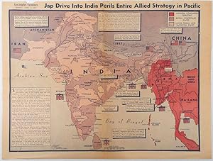
Colour pictorial map on a single newspaper leaf 37 x 50 cms; 41.5 x 54.6 cms (sheet), unrelated text on the verso (although with an interesting account from a soldier's letter about an air raid in China), toning, more marked at the central fold (two small splits, no loss to the map), edge wear with several small marginal edge te…ars neatly repaired on the verso with archival washi (map unaffected), in good condition. A dynamic map prepared and illustrated by the Examiner's art critic and editor Howard Burke, covering the area surrounding India and Central Asia showing Japanese conquered territory in Malaya, Thailand, Indo-China and Burma; and in India British-controlled states and native feudal and protected states. Text boxes and pictographs give an overview of the geopolitical situation, from the Allied perspective. One box notes "Chanda Bose has many adherents and fanatical followers in Bengal. They may prove to be a powerful fifth column in India". Text at lower edge opines "The situation in India is critical and has grown more so as the all-out offensive against Japan has been delayed. If the Allies do not act at once, and with great force, all our gains may be wiped out and the war in the Pacific prolonged indefinitely." The decisive and devastating bombings that were to signal such an end were four months away. Rare on the market.
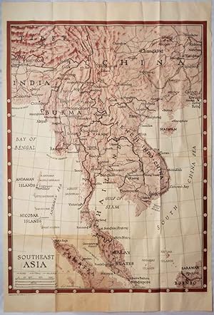
Southeast Asia. Orientation Map Series No. 6.
[SOUTHEAST ASIA - WORLD WAR II MAP] MANNING, F.E. (CARTOGRAPHER)
Published by Army Orientation Branch, USGPO, Washington, D.C., 1944
Seller: Asia Bookroom ANZAAB/ILAB, Canberra, ACT, AustraliaAsia Bookroom ANZAAB/ILAB
Contact seller5-star sellerCondition: Used
US$ 536.05
US$ 21.25 shippingShips from Australia to U.S.A.Quantity: 1 available
Very large folding two-colour map, 138.5 x 101 cms; sheet 157.3 x 105.5 cms, folded to sixteenths, 39.5 x 26.5 cms (as issued),toning to a lower left panel and the central fold, some small holes at some of the fold points but now repaired on th verso with archival washi, generally in very good condition. Colour map of the extend…ed area from the Ganges and Calcutta to Hong Kong, and from Tibet and Hankow in China to Singapore, with part of Sarawak and Borneo and the northern part of Sumatra, together with the Andaman and Nicobar Islands. The McMahon line delineating the border between Tibet and India is not observed, nor the 1941 border established between France and Thailand (following the Mekong River). This map is by the Chicago Sun cartographer F. E. Manning, produced for the Army Orientation Branch. A smaller version was also included with the Newsmap issue of January 17th 1944.


