Order Total (1 Item Items):
Shipping Destination:

Wwii Map (32 results)
Author:
wwii map
Refine with Advanced Search
Skip to main search results
Search filters
Product Type
- All Product Types
- Books (18)
- Magazines & Periodicals (No further results match this refinement)
- Comics (No further results match this refinement)
- Sheet Music (No further results match this refinement)
- Art, Prints & Posters (No further results match this refinement)
- Photographs (No further results match this refinement)
- Maps (14)
- Manuscripts & Paper Collectibles (No further results match this refinement)
Condition Learn more
- New (No further results match this refinement)
- As New, Fine or Near Fine (No further results match this refinement)
- Very Good or Good (1)
- Fair or Poor (No further results match this refinement)
- As Described (31)
Binding
Collectible Attributes
- First Edition (No further results match this refinement)
- Signed (1)
- Dust Jacket (No further results match this refinement)
- Seller-Supplied Images (32)
- Not Print on Demand (32)
Language (1)
Free Shipping
- Free Shipping to U.S.A. (No further results match this refinement)
Seller Location
Seller Rating
-
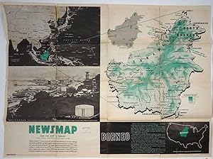
WWII Newsmap for the Armed Forces. Borneo. VE Day + 8 Weeks
Published by Army Information Branch, Army Service Forces, New York, 1945
Seller: Antipodean Books, Maps & Prints, ABAA, Garrison, NY, U.S.A.
Association Member: ABAA ANZAAB ESA ILAB
Seller rating 3 out of 5 stars

Condition: Good + condition. 185th Week of U.S. Participation in the War. Monday, 2 July, 1945. Volume IV, No. 11F. Large printed color double sided folding map. A two color map on one side of Borneo showing elevation at the right side, and with printed information on the recapture of Borneo by the Allies. A smaller map shows the Pacific Arena with Borneo and Sarawak printed in green. Below this is a b&w printed photo illustration of the port area of Balikpapan with caption: "Scene of extensive oil installations before Jap occupation early in 1942 has been target of recent heavy Allied air and sea blows." On the verso is color poster of an American woman holding a hammer, having just nailed up some lucky horseshoes, and saying of her spouse, "Now . If He Will Just Save Some Money . everything will be OK". These war maps were issued by the US War Department in WWII to the public and to military personnel as visual guides to campaigns, and usually featured the theater of conflict, and often included text descriptions of war related events. 47 x 35", printed on both sides. Some splits at folds, slight loss; chipped at edges. Michigan State Library stamp on verso.
-

1939 Grossdeutschland
Seller: New World Cartographic, Chicago, IL, U.S.A.
Seller rating 4 out of 5 stars

Map
By: Richard Edes Harrison Pub. Fortune MagazineDate: September 1939 - New York, NY Dimensions: 13.75 x 22 inches (35 x 56 cm)This is a WWII era map depicting Germany, its resources, industries, and other factors to take into consideration with regards to their potential as an adversary in war. The map appeared in the September 1939 issue of Fortune Magazine.The work consist of eight maps presenting different data sets that include mineral, livestock, and agricultural products, basic and consumer industries, rail and aviation systems between Germany and their neighbors, as well as internal transportation systems. The first map at top left compares the population density and latitude of Germany to the United States.The title of the mapGrossdeutschland translates to "Greater Germany" or "Big Germany," which in this case refers to the ideaa single German state that included Austria. The name wasinformally adopted by Nazi Germany after annexing Austria in March of 1938 at the very beginning of WWII.Condition: Map is in A condition, printed on two separate sheets and professionally joined at the center. Paper is clean without any tears and the colors are vibrant.Inventory #114671200 W. 35th Street #425 Chicago, IL 60609 | P: (312) 496 - 3622.
-
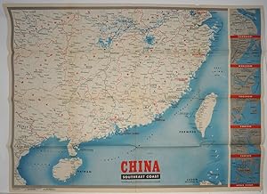
WWII Newsmap for the Armed Forces. China Southeast Coast
Published by Army Information Branch, Army Service Forces, New York, 1944
Seller: Antipodean Books, Maps & Prints, ABAA, Garrison, NY, U.S.A.
Association Member: ABAA ANZAAB ESA ILAB
Seller rating 3 out of 5 stars
Map. Condition: Very good condition. Large printed color folding map of China and its southeast coast, extending from Shanghai down to Formosa and Hainan and French Indo China. With inset maps of the vicinities of Hong Kong, Canton, Swatow, Foochow, Wenchow and Shanghai printed down the right side. These war maps were issued by the US War Department in WWII to the public and to military personnel as visual guides to campaigns, and usually featured the theater of conflict, and often included text descriptions of war related events. 47 x 35", printed on one side. Volume III, No. 518 printed at lower left. Some small cracks at fold intersections; the word "China" in manuscript on verso.
-

???????????????? Hyo?jun Daito?a bunzu daito?a bunzu: ?sutorariyahen. Standard Maps of Greater East Asia: Complete Map of Australia.
Published by To?seisha. Showa 18 [1943], Tokyo., 1943
Seller: Asia Bookroom ANZAAB/ILAB, Canberra, ACT, Australia
Association Member: ANZAAB ILAB
Seller rating 5 out of 5 stars

Folding colour map of Australia, 54.2 x 76.4cm. Some foxing particularly along folds and upper right margins a few repaired tears and small holes at folds.With original sleeve. The 15th map in the Standard Maps of Greater East Asia series (of 20 maps). Shows the natural resources such as sheep, gold, pearl, diary regions, opals etc. Tasmania appears as an inset in the bottom right corner. Text in Japanese.
-
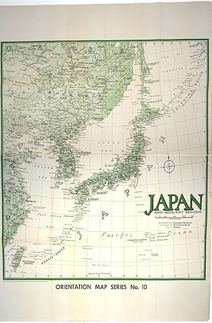
Moscow to Berlin. Japan and Adjacent Regions. US Army Orientation map
Published by Army Orientation Branch, Morale Services Division, Washington DC, 1945
Seller: Antipodean Books, Maps & Prints, ABAA, Garrison, NY, U.S.A.
Association Member: ABAA ANZAAB ESA ILAB
Seller rating 3 out of 5 stars
Condition: Very good overall. A very large double sided US Army Map WWII created by the Orientation Branch, whose mission was to strengthen the leadership of junior officers and to give every soldier a sense of personal mission in the part his unit was playing. Orientation map series 9 & 10. 'Moscow to Berlin", Orientation Map Series No. 9, showing Europe from Finland down to Bulgaria and from Berlin over to Moscow, and centered on Poland with legend showing 'Pre War boundaries' as dashed line and 'Boundaries Established after 1939' as dotted line. Verso with 'Japan and Adjacent Regions", Orientation Map Series No. 10, showing Japan as well as the USSR, Manchuria, and the Chinese coast down to Taiwan. Legend shows International Boundaries and Provincial Boundaries, & Railroads. Printed in green and black. Double sided map, both sides printed in color. 40 1/2 x 56". Short tears along one edge, otherwise very bright and clean, period folds flattened. OCLC: 888423436 records only one copy, at Harvard.
-

American Roads to Peace
Published by Los Angeles Examiner. Sunday 1 May1938., Los Angeles., 1938
Seller: Asia Bookroom ANZAAB/ILAB, Canberra, ACT, Australia
Association Member: ANZAAB ILAB
Seller rating 5 out of 5 stars
Printed colour pictorial map 33 x 48 cms; 41.8 x 54.5 cms (sheet) central fold, sheet toned, corners chipped with some loss to the bottom border and at the central fold, in good condition; and on the verso "Movie-Go-Round" by Louella O. Parsons, black and white photos and advertisements. Pictorial map printed for the weekend supplement of the Randolph Hearst owned newspaper the Los Angeles Examiner. The map-maker and artist Howard Burke had also worked for the San Francisco Examiner and was known for pictorial maps, many with a persuasive or rhetorical edge, and as here, were designed to shore up American patriotism and defences against a wider world in the increasingly turbulent pre-war 1930s. The caption to this map outlines a multi-billion dollar 25 year proposal by Congressman J. Buell Snyder for a network of coast to coast transcontinental highways "in case of an attack by a foreign power at any point along the border". Buell Snyder earned the soubriquet "the father of superhighways" and during the War he was assigned to a Congressional Committee in charge of appropriations for the War Department. Scarce.
-
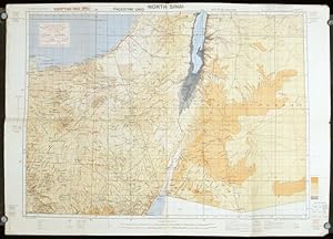
Egypt. North Sinai. Sheet 3.
Published by Royal Engineers. July1942., (London)., 1942
Seller: Asia Bookroom ANZAAB/ILAB, Canberra, ACT, Australia
Association Member: ANZAAB ILAB
Seller rating 5 out of 5 stars
Printed colour topographical map mounted on linen, 56.7 x 79.2 cms; 64.6 x 89. 5 cms (sheet) original folds, edgewear, small marginal chips, a little dusty, but in good condition. Detailed World War II operational map of Egypt and the Middle East, issued by 512 Army Field Survey Company of the Royal Engineers. The map is marked "Not to be Published" in the upper right margin. Railways, roads, camel tracks, telegraph lines, boundaries, altitudes, towns and villages are marked.
-

Java & Madura. 1:50,000. Djombang. Sheet 53/XLIC. (HIND 1090).
Published by Army Map Service., Washington, D.C., 1945
Seller: Asia Bookroom ANZAAB/ILAB, Canberra, ACT, Australia
Association Member: ANZAAB ILAB
Seller rating 5 out of 5 stars
First edition - revised (AMS4). Army survey map printed in colour, 36.7 x 36.7 cm; 58 x 48 cm (sheet), conversion graph, glossary and administrative index to the inner margin; scale, three column legend, index to adjoining sheets and notes re grid references and mean declination to the foot; sheet toned, a very few edge tears, the map in very good condition. Wartime map produced by the US Army Map Service (AMS) who formed in 1942 and were at the forefront of military mapping campaigns during WWII and the post-war years. The very detailed map shows residency and administrative boundaries, transportation, ground and water features, vegetation, cultivation, ruins, religious sites "Graves; Chinese, native," and "Cemetery; heathen, Christian", walls, hedges, populated places, built-up areas and buildings (with those of iron, stone, wood and bamboo differentiated by colour); fishponds, plantations and much more.
-
New Map of Japan.
Published by Nihon-Kenkyusha., Tokyo., 1935
Seller: Asia Bookroom ANZAAB/ILAB, Canberra, ACT, Australia
Association Member: ANZAAB ILAB
Seller rating 5 out of 5 stars
Large folding colour map of Japan 74.3 x 10⁵ cms; folding into printed card covers 27 x 19.5 cms: 9 insets: Chosen (Korea); Hokkaido; Chisima Islands; General Map of Japan and Manchuokuo; Karafuto (Saghalien); Okinawa (Loochoo); Taiwan (Formosa); Micronesia; Ogasawara; Hajijoshima; the covers a litle worn and marked, and the sheet slightly toned, but the map is in very bright, clean condition. Scarce World War II era map of Japan (including Korea), published in English by Kenkyusha. Founded in 1907, it had a history of publishing for students of English and the English market. An attractively composed map in remarkbable condition; with the insets circled around the islands of Japan, heights marked in graduations from green to red, and showing provinces, railways, roads, steamer routes, Buddhist and Shinto Temples.
-
Tokyo City Proper.
Published by U. S. Army, 1945
Seller: Asia Bookroom ANZAAB/ILAB, Canberra, ACT, Australia
Association Member: ANZAAB ILAB
Seller rating 5 out of 5 stars
Folding black and white English language pictographic street map, 38.4 x 56.2 cm; 44.5 x 57 (sheet), inset map of the Ginza; a little dusty and soiled at the folds, and on the verso, small hole along lower left fold; in good condition. Unusual map of Tokyo reprinted in August 1945 on the eve of occupation, by the U.S Army and the 960th Engineer Aviation Topographic Company distinguished by its small depictions of Tokyo's key sites and buildings, rendered to scale. The Government Railway Line, Private Tramway Line, Municipal Tramway Line, Subway line, and Tokyo Sightseeing Route are marked. At lower left is an inset detail map of the Ginza district with vignette illustrations of the building including the Head Office of the Dai-Nippon Brewery, S. Watanabe (woodblock print) store, and Matsuya and Mitsukoshi Department Stores.
-
A New War Map of the Aleutian Island Sea Road to Japan. [caption title]
Published by Chicago Daily Tribune. 28 January,1942., Chicago., 1942
Seller: Asia Bookroom ANZAAB/ILAB, Canberra, ACT, Australia
Association Member: ANZAAB ILAB
Seller rating 5 out of 5 stars
Printed colour map, 40.3 x 53.6 cm; 46.5 x 60 cm (sheet), inset map of the North Pacific, back cover from a section of the Chicago Daily Tribune newspaper (pages 21-34) January 28, 1942; central fold, edgewear and browning with a few minor tears not affecting the map, in very good condition. Based on a Rand McNally map and issued less than two months after the bombing of Pearl Harbour by the Japanese. The Tribune briskly got to work issuing maps for readers showing the beginnings of the war with Japan. Later maps were also published for sale separately, but remarkably few have survived. The map shows "the nearness of our Aleutian Island chain, west of Alaska, to the islands of Japan. At Dutch Harbor and other points in the Aleutians are actual and potential sea and air bases, lying on the shortest route from northwestern United States to Japan." The inset map at lower right situates the areas in the larger map in respect to the countries bordering the North Pacific Ocean. Included with the map is the complete newspaper section from which it is the final full page. Covering sport and the market (with half a dozen popular comic strips including "Dick Tracy" and "Little Orphan Annie") it shows a domestic United States a world away from what had been seen as a European War. ". the historic Chicago Tribune was an innovator in color inks and printing, but also a pioneer in bringing colorful art in the form of illustrations, photographs, cartoons and advertisements to the average person in an everyday medium." [see The Janet A. Ginsburg Chicago Tribune Collection, Michigan State University Libraries.]".
-
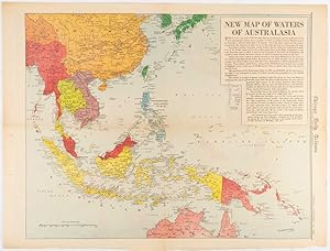
New Map of Waters of Australasia.
Published by Chicago Daily Tribune. December 161942., Chicago., 1619
Seller: Asia Bookroom ANZAAB/ILAB, Canberra, ACT, Australia
Association Member: ANZAAB ILAB
Seller rating 5 out of 5 stars
Printed colour map on a single newspaper leaf 41.6 x 52.8 cm; 45 x 60 cm (sheet), inset legends, marginal browning and at the folds, but remarkably bright, in very good condition. Map of Southeast Asia published in the Chicago Daily Tribune "The World's Greatest Newspaper" delineating the Pacific theatre of war with a detailed text legend. "This is a new war map of the far east, showing an important part of southeastern Asia and Australasian waters, from a station in which, according to Prime Minister Curtin of Australia, a United States fleet will operate." Interestingly New Guinea is marked as British, rather than as an Australian administrative region which it became following the Treaty of Versailles. "? the historic Chicago Tribune was an innovator in color inks and printing, but also a pioneer in bringing colorful art in the form of illustrations, photographs, cartoons and advertisements to the average person in an everyday medium." [see The Janet A. Ginsburg Chicago Tribune Collection, Michigan State University Libraries.].
-
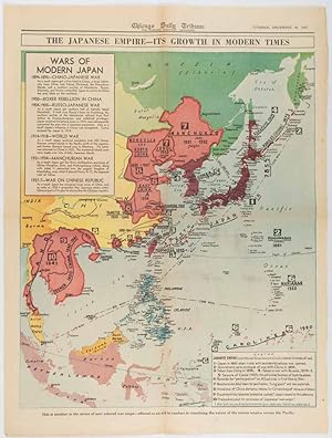
The Japanese Empire -- Its Growth in Modern Times
Published by Chicago Daily Tribune. December 161941., Chicago., 1619
Seller: Asia Bookroom ANZAAB/ILAB, Canberra, ACT, Australia
Association Member: ANZAAB ILAB
Seller rating 5 out of 5 stars
Printed colour map on a single newspaper leaf 50 x 41.5 cm; 60 x 45 cm (sheet), two inset legends, marginal browning and at the folds, but remarkably bright, in very good condition. Map of the Japanese Empire published in the Chicago Daily Tribune "The World's Greatest Newspaper" on December 16th 1941, 9 days after the bombing of Pearl Harbour. The two legends list the "Wars of Modern Japan" from 1894, with territorial gains marked, noting that "Each seizure of mainland areas has given Japan new field of raw materials." "? the historic Chicago Tribune was an innovator in color inks and printing, but also a pioneer in bringing colorful art in the form of illustrations, photographs, cartoons and advertisements to the average person in an everyday medium." [see The Janet A. Ginsburg Chicago Tribune Collection, Michigan State University Libraries.].
-

New War Map of Continental Asia from Siberia to Singapore
Published by Chicago Daily Tribune. January 91942., Chicago.
Seller: Asia Bookroom ANZAAB/ILAB, Canberra, ACT, Australia
Association Member: ANZAAB ILAB
Seller rating 5 out of 5 stars
Printed colour map on a single newspaper leaf 37.2 x 53.4 cm; 45 x 59.9 cm (sheet), inset legend, marginal browning and at the folds, lower margin with small edges tears (not affecting the caption), but remarkably bright, in very good condition. Rare map of Asia "Between Suez on the west and Shanghai on the east" showing territorial interests and theatres of war, published in the Chicago Daily Tribune in January 1942, barely two months after the Uniited States had joined the war effort after the bombing of Pearl Harbour. Thailand and Vietnam ("French Indo-China") are marked "Occupied by the Japanese" and north-eastern China similarly marked, Iran "Anglo-Russian Occupation" and the Gulf states "British Ally". The caption notes that "The map inludes waters thru which runs the British life line from the Suez canal to remote Australia and New Zealand. Nearly half the people in the world live in the lands shown on this map--more than 450 million, for example, in China, and more than 375 million in India". ". the historic Chicago Tribune was an innovator in color inks and printing, but also a pioneer in bringing colorful art in the form of illustrations, photographs, cartoons and advertisements to the average person in an everyday medium." [see The Janet A. Ginsburg Chicago Tribune Collection, Michigan State University Libraries.].
-
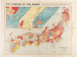
The Domain of the Enemy
Published by Chicago Daily Tribune. December 121941., Chicago., 1219
Seller: Asia Bookroom ANZAAB/ILAB, Canberra, ACT, Australia
Association Member: ANZAAB ILAB
Seller rating 5 out of 5 stars
Printed colour map on a single newspaper leaf 41.5 x 53 cm; 45.1 x 59.9 cm (sheet), three inset maps of the Japanese Empire; Taiwan and Ryukyu Islands; and Hokkaido and Chisima, marginal browning and at the central fold, but remarkably bright, in very good condition. Map of the Japanese Empire, ominously titled, published in the Chicago Daily Tribune one week after the bombing of Pearl Harbour. Prefectures are attractively coloured. Based on a Rand McNally map, the Tribune briskly got to work issuing maps for readers showing the beginnings of the war with Japan. Later maps were also published for sale separately, but remarkably few have survived. ". the historic Chicago Tribune was an innovator in color inks and printing, but also a pioneer in bringing colorful art in the form of illustrations, photographs, cartoons and advertisements to the average person in an everyday medium." [see The Janet A. Ginsburg Chicago Tribune Collection, Michigan State University Libraries.].
-

War Map of China and Contiguous Lands.
Published by Chicago Daily Tribune. January 151942., Chicago., 1519
Seller: Asia Bookroom ANZAAB/ILAB, Canberra, ACT, Australia
Association Member: ANZAAB ILAB
Seller rating 5 out of 5 stars
Printed colour map on a single newspaper leaf 53 x 40.7 cm; 59.8 x 45 cm (sheet), inset text box, marginal browning and at the folds, but remarkably bright, in very good condition. WWII map of China, showing most of China, Indo-China, Thailand and Korea, with territory captured and controlled by Japan shaded in orange and red, published by the Chicago Daily Tribune barely six weeks after the bombing of Pearl Harbour. The text on the map reads "Since 1937 China has been at war with Japan. Lacking many essentials of war, the Chinese nevertheless, have managed to maintain a front against the aggressors. China's principal life line is the Burma road (shown on the map), which starts at Lashio, Burma, and extends to Kunming, Yunnan province, where it links with connections to Chunking, the present Chinese capital". Based on a Rand McNally map, the Tribune briskly got to work issuing maps for readers showing the beginnings of the war with Japan. Later maps were also published for sale separately, but remarkably few have survived. "? the historic Chicago Tribune was an innovator in color inks and printing, but also a pioneer in bringing colorful art in the form of illustrations, photographs, cartoons and advertisements to the average person in an everyday medium." [see The Janet A. Ginsburg Chicago Tribune Collection, Michigan State University Libraries.].
-

New Map of War Fronts in Indian Ocean and Bengal Bay.
Published by Chicago Daily Tribune. April 211942., Chicago.
Seller: Asia Bookroom ANZAAB/ILAB, Canberra, ACT, Australia
Association Member: ANZAAB ILAB
Seller rating 5 out of 5 stars
Printed colour map on a single newspaper leaf 37.5 x 53.2 cm; 60 x 45 x 59.6 cm (sheet), marginal browning and at the folds, but remarkably bright, in very good condition. World War II map of Asia (save for Japan), showing British allies, colonies and lines of supply and marking Japanese territorial occupation, published in the Chicago Daily Tribune "The World's Greatest Newspaper" in April 1942. "The Indian Ocean and the Bay of Bengal are the strategic waters in this campaign, in which the occupied parts of Burma and the Andaman Islands serve as bases" (caption) ". the historic Chicago Tribune was an innovator in color inks and printing, but also a pioneer in bringing colorful art in the form of illustrations, photographs, cartoons and advertisements to the average person in an everyday medium." [see The Janet A. Ginsburg Chicago Tribune Collection, Michigan State University Libraries.].
-
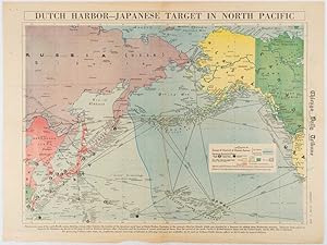
Dutch Harbor -- Japanese Target in the North Pacific.
Published by Chicago Daily Tribune. Friday, June 5,1942., Chicago., 1942
Seller: Asia Bookroom ANZAAB/ILAB, Canberra, ACT, Australia
Association Member: ANZAAB ILAB
Seller rating 5 out of 5 stars
Printed colour map on a single newspaper leaf 37.5 x 53.2 cm; 44.7 x 59.8 cm (sheet), inset legend, marginal browning and at the folds, some undulation of paper and tide mark along lower section but in remarkably bright very good condition. Strategic map published in the Chicago Daily Tribune "The World's Greatest Newspaper" on June 5th 1942, two days after the Japanese attack on Dutch Harbor, the site of the US army and navy bases in the Aleutians, and as it transpired, at the outset of the Battle of MIdway. The owner and proprietor of the Tribune, Robert McCormick, was staunchly against the United States entering the war and had firm views, once it had occurred, that American resources should not be used defending the British Empire. Famously, the Tribune published the "Victory Program," Roosevelt?s military plan to prepare the United States for possible entry into World War II, and was subject to prosecution for an alleged violation of the Espionage Act relating to the newspaper?s front-page account of the Battle of Midway, 4-7 June, 1942. It became an important test case for the limits of free speech and censorship during war-time. The Legend shows territorial Control of Ocean Areas, marking Japanese Naval and Air bases as of 1941 and "according to latest reports" those established in the first six months of 1942. Also shown are pre-war sovereignties (as at the bombing of Pearl Harbour on December 7th 1941). The Anson Archipelago is shown, but a question mark "indicates islands etc., whose existence or give position is doubtful?".
-
After Victory -
Publication Date: 1943
Seller: Geographicus Rare Antique Maps, Brooklyn, NY, U.S.A.
Association Member: ABAA ESA ILAB
Seller rating 4 out of 5 stars
Map
Soft cover. Very good. Size 15 x 15 Inches. This is a scarce 1943 map and pamphlet published by the Florida Department of Agriculture promoting veteran emigration after World War II. A Closer Look Enclosed in its original cartoon-decorated mailer, this 32-page, mostly pictorial brochure promotes all aspects of Florida life, from agriculture and industry to the state's natural beauty and famed resort culture. The two pages of the introductory text are unambiguous in their intent to lure returning soldiers to Florida, where it is promised that 'a new life will begin after victory'. The phamplet is accompanied by a separate note reading 'We suggest that after you have read this booklet you mail it to your family, your sweetheart or a friend at home, using the mailing envelope provided.' The attached map, Scenic and Picturesque Florida , was drawn by George D. Way. Vignettes highlight attractions from Pensacola to Key West. These include national parks, forests, beaches, museums, wildlife sanctuaries, gardens, and zoos. Florida is portrayed as America's outdoor playground, with activities including tennis, golf, waterskiing, fishing, and boating taking center stage. This map was subsequently reused in various tourist brochures throughout the 1940s and 50s. Florida's Post WWII Boom By 1943, Allied Victory in World War II (1939 - 1945) was all but assured. The Florida Legislature recognized an opportunity. Many WWII soldiers would have already had a taste for Florida, having trained and served on one of the state's large military bases. Florida's appeal was hard to deny; it was a sprawling state with cheap land, endless beaches, a commodious climate, and a resort culture that hinted at new beginnings. This and other pamphlets were published by various Florida state offices to entice returning veterans. The campaign was a resounding success, with thousands resettling throughout Florida, drawn by economic opportunities, affordable land, and a burgeoning job market fueled this migration wave. New suburban communities, facilitated by the construction boom and the proliferation of automobile culture, offered the quintessential American dream of homeownership and a laid-back lifestyle. This influx of domestic migrants significantly contributed to Florida's population growth, laying the foundation for its emergence as one of the fastest-growing states in the post-war era. Publication History and Census This pamphlet was published in 1943 by the Florida Department of Agriculture, Bureau of Immigration, headed by Nathan Mayo. The contained map was drawn by George D. Way. The current example accompanies its original decorative mailer, 'This Army Stuff for you'. We note an example at the Tampa Bay History Center, Touchton Library, otherwise scarce to the market. References: OCLC 29942589. Tampa Bay History Center, Touchton Map Library, 2018.136.002, L2019.081.005, 2001.101.001.
-

Philippine Islands
Publication Date: 1945
Seller: Geographicus Rare Antique Maps, Brooklyn, NY, U.S.A.
Association Member: ABAA ESA ILAB
Seller rating 4 out of 5 stars
Map
Hardcover. Very good. Minor wear on original fold lines. Size 28.5 x 21.25 Inches. An unusual and unique c. 1945 cyanotype or blueprint map of the Philippines issued by the Japanese, probably during the Philippine Campaign. This is an enigmatic map of which we can deduce little. The map covers all of the Philippine islands. The presence of Japanese text suggests that the map is most likely related to World War II, a fact belied by its crudity. The cyanotype seems to be derived from a crude manuscript copy of a western map - to which a Japanese title has been appended. An inset in the upper right details the Luzon Strait and Bashi Channel (between Taiwan and Luzon), an important region for Japanese forces. Part of Northern Luzon, and an area continuing into the inset, is highlighted in red manuscript and coincidently illustrates the primary zone of Japanese influence in 1944 - 45. The Philippine Campaign Launched on October 20 of 1944, the Philippine Campaign was a World War II joint American and Filipino military operation intended to liberate the Philippine Islands from occupying Imperial Japanese forces. The Japanese Army overran most of the Philippines during the first half of 1942, retaining it for the subsequent 2 years. American General Douglas MacArthur began the campaign by announcing on Philippine radio 'This is the Voice of Freedom, General MacArthur speaking. People of the Philippines: I have returned.' The campaign progressed rapidly, driving the Japanese out of one island after another. Although by this time the Japanese were clearly losing the war, they gave no sign of capitulation and refused to surrender. During the course of the campaign Japan suffered nearly half a million casualties compared to only about 50,000 Americans. The campaign continued until Japanese forces in the Philippines were ordered to surrender by Tokyo on August 15, 1945, after the dropping of atomic bombs on Hiroshima and Nagasaki. Cyanotype: Why so Blue? Cyanotype is a photo-reprographic technique developed in 1842 by the British astronomer John Herschel (1792 - 1871). Sometimes called a 'sunprint', the technique employs a solution of ferric ammonium citrate and potassium ferricyanide , which painted on white paper or cloth, reacts when exposed to sunlight to dye the object a brilliant blue. Areas blocked from ultraviolet exposure remain undyed and white. Herschel developed the technique to reproduce his astronomical notes, but others quickly realized that any object capable of blocking light could be used to quickly and easily create a cyanotype image. By the late 19th century the process became popular with designers, military, architects, and engineers (blueprints), who used the cheap an effective technique to quickly and exactly reproduce images in the field. Cyanotyping is limited in that only a single copy can be made at one time, so it was only practical for short-term field work. It is also of note that cyanotypes remain extremely reactive to light and, over time, fade or degrade, making them extremely ephemeral. The process fell out of fashion in most places by the 1920s, but remains in use in some parts of the world, such as India and Nepal, to this day. Publication History and Census This map appears to be cyanotype issue of a one-off manuscript copy of a western map - most likely made during World War II. The cyanotype form underscores that very few could have been issued, typically only 2 or 3, and suggests that it may have been a field map of some kind. Probably the only known example.
-

Japan's Main Islands - Where Americans Will Land.
Published by Chicago Daily Tribune. August,1945., Chicago., 1945
Seller: Asia Bookroom ANZAAB/ILAB, Canberra, ACT, Australia
Association Member: ANZAAB ILAB
Seller rating 5 out of 5 stars
Printed colour pictorial map on a single newspaper leaf, 37 x 52 cms; 43 x 59.5 cms (sheet), three inset maps, archivally laid down on linen, very good condition. Full page map published in the "Chicago Daily Tribune" after the bombing of Hiroshima and Nagasaki prior to occupation by US and Allied forces in September, 1945. "This is a new map of the main islands of Japan, where American occupational troops will land and establish their military rule." (map text) The legend notes "Places bombed by U.S. Air Forces with a red circle" and "Cities bombed by Atomic Bomb" with a red star. The main map shows the Japanese islands of Honshu, Shikoku and Kyushu, with the Korean peninsula. Inset maps show Hokkaido, Formosa and a general map of the area.
-

Superfortress School Seattle, Wash. Areas 1 and 2.
Publication Date: 1945
Seller: Geographicus Rare Antique Maps, Brooklyn, NY, U.S.A.
Association Member: ABAA ESA ILAB
Seller rating 4 out of 5 stars
Map
Very good. Light wear along original fold lines. Manuscript notations. Was three hole punched. Blank on verso. Size 8.25 x 10.25 Inches. This is a c. 1945 Boeing map of their 'Superfortress School' at an airfield outside Seattle, Washington. The map depicts the school's campus, with manuscript notations marking barracks, school buildings, library, mess hall, PX (Post Exchange), homes, and the shipping and receiving area. Three buildings are marked as hangers in manuscript, with sketches of three airplanes present near these hangers. Arrows point the way to the air field, downtown Seattle, the Pacific Ocean, and Long Beach. Boeing's Superfortress School Organized during World War II at the behest of the U.S. Army Air Force, the school taught mechanics and other ground personnel to work on the B-29 Superfortress. Established in 1944, planes were in such short supply that school officials had to scavenge aircraft crashed in training accidents from across the country to give their incoming students machines on which to train. They also asked for planes that were going to be retired. By the time the school was shut down in October 1945, over 25,000 men had been graduated. Publication History This map was created by Boeing and published c. 1945.
-

The Pacific Ocean.
Publication Date: 1943
Seller: Geographicus Rare Antique Maps, Brooklyn, NY, U.S.A.
Association Member: ABAA ESA ILAB
Seller rating 4 out of 5 stars
Map
Very good. Exhibits light wear along original fold lines. Blank on verso. Size 21 x 18.5 Inches. This is a 1943 Kermit Johnson and Civic Education Service map of the Pacific during World War II. The map's main focus is the vast distances involved in fighting a war across the Pacific. It illuminates in a simple, straightforward way the challenge of transporting troops and supplies from the United States to Australia, where American supplies were staged. The text along bottom border puts this in perspective, 'In area it [the Pacific] is greater than all the land surface of the world. In width - 10,000 miles at the equator - it makes the Atlantic seems small by comparison.' Johnson uses silhouettes of cargo ships and planes to differentiate between routes (although they are illustrated here as being practically identical). Importance of Islands The text also emphasizes the importance of islands for the Pacific War, calling them 'stationary aircraft carriers' and highlighting the important role they play as staging areas, places for soldiers to relax, and refueling stops for airplanes flying from the U.S. and Hawaii. Both Japan and the Allies relied on islands to project power across the Pacific. While little detail is provided about the current state of the war, areas occupied by Japan, including China, Manchukuo, the Philippines, Indonesia, and the Solomon Islands, are shaded black. Publication History and Census This map was drawn by Kermit Johnson and published by the Civic Education Service in 1943. At least two other maps were published in this series and illustrate the Atlantic Ocean and the Indian Ocean. Examples of the Atlantic Ocean and Indian Ocean maps are catalogued in OCLC, but the Pacific Ocean map does not appear, making this the only example we have been able to trace.
-

Defense Map of the United States Prepared by C.S. Hammond and Company, N.Y. Showing the Mobilization of our Military and Economic Resources.
Publication Date: 1941
Seller: Geographicus Rare Antique Maps, Brooklyn, NY, U.S.A.
Association Member: ABAA ESA ILAB
Seller rating 4 out of 5 stars
Map
Good condition. Exhibits wear along original fold lines, especially at fold intersection, where there are some verso reinforcements. Exhibits some toning. Size 22 x 32 Inches. This is a c. 1941 C. S. Hammond and Company pictorial map of the United States highlighting the military and economic resources available on the brink of World War II. Blue-colored cogs highlight industrial areas around the country to illustrate the manufacturing might that could be brought to bear. Other defense industries are marked on the map by icons, including shipyards, factories for making planes, airplane engines, munitions, tanks, guns, steel, and aluminum. Army and navy bases are identified as well, as are army and navy airfields. The Pictorial Border - A Show of Military Force It is the pictorial border, however, that immediately draws the viewer's attention. The air, land, and sea forces of the United States military are put on full display, creating a forceful image that undoubtedly counts as propaganda and shouts 'support the military'. Cutting edge aircraft, such as the Boeing B-17 Flying Fortress, Consolidated B-24 Liberator, Lockheed P-38 Lightning, Grumman F4F Wildcat, and Curtiss P-40 Warhawk, are prominently illustrated along the map's top border. Tanks, artillery guns, howitzers, and supply trucks along the map's two sides represent ground forces. The Navy Perhaps the most incredible part of this piece (with the benefit of hindsight of course) is the placement of the battleship front and center along the bottom border. The legendary naval engagements fought between the United States and Japan had not yet occurred, and naval strategists believed that the battleship, not the aircraft carrier, would be the key element to success on the world's oceans. An aircraft carrier appears to the right of the battleship, complete with its aircraft on the flight deck. A heavy cruiser steams to the battleship's left, surrounded by torpedo boats, light cruisers, destroyers, and submarines. Insignia Illustrations of American Army and Navy insignia frame the entire piece, with army insignia on the left and navy insignia on the right. Army insignia of rank, from general to private first class, are situated at the top left, while insignia of 'arms and services', such as the infantry, ordnance department, signal corps, and medical corps, are on the bottom left. Naval insignia of rank are just opposite, on the top right, while naval specialty marks, such as sharpshooter, bugler, machinist's mate, and cook, are on the bottom right. A sample of Army and Navy Air Corps insignia are included along the top, while the insignia of army headquarters, field armies, army corps, and army divisions are along the bottom. Publication History and Census This map was created by C.S. Hammond and Company and published c. 1941. The OCLC catalogues examples of this map as being part of fourteen institutional collections, but it is scarce on the private market. References: Curtis, P. and J. Pedersen, War Map p. 132-33. Rumsey 8840.000. OCLC 66898853.
-

To Belgium and Back with the 79th Infantry Division 31 Aug to 25 Oct, 1944.
Publication Date: 1945
Seller: Geographicus Rare Antique Maps, Brooklyn, NY, U.S.A.
Association Member: ABAA ESA ILAB
Seller rating 4 out of 5 stars
Map
Very good. Even overall toning. Light soiling. Wear along margins. Closed margin tears professionally repaired on verso. Closed tears extending 1.5 inches from right margin and 1 inch from left margin into printed area professionally repaired on verso. Blank on verso. Size 26 x 33 Inches. This is a 1945 Steve Kaliher and Harry D. White pictorial map of the 79th Infantry Division's route through eastern France from north of Paris near the Oise River to the Parroy Forest. The second in a series of four maps depicting the division's advance through Europe after the Allied invasion, this map follows the division's movements from August 31 until October 25, 1944, when the division was pulled off the combat line for rest and training. Solid black arrows trace the division's progress, with red lettering indicating the date (or dates) spent in a specific location. A Look at the 79th Division's Advance Text along the left border states that, following the division's successful breakout from the Seine bridgehead near Mantes Gassicourt, it began a 'record-breaking' advance toward the Franco-Belgian border, which, per the map, was deemed 'one of the fasted opposed advances of comparable distance by an infantry division in wartime'. The divisions momentum was slowed, however, upon reaching St. Amand, on the Belgian border, where they encountered stiff resistance. They then turned south, through Valenciennes, Reims, and Neufchateau, until they again encountered fierce resistance at Charmes, where they fought street by street. Here they managed to secure yet another bridgehead, this time across the Moselle River, that allowed the Allied advance to continue east. They then proceeded to the Parroy Forest, where they fought one last intense engagement before being pulled off the line on October 24. Map details Numerous cities, towns, and villages are labeled throughout, allowing the viewer to orient themselves to what part of France the 79th Division is liberating, some of which would have been familiar to World War I veterans, like Verdun. Several rivers, including the Oise, Aisne, Somme, Meuse, and Marne are labeled The Reims Cathedral is beautifully illustrated, adding a different dimension to the reality of the speedy advance through the French countryside. A column of American troops, complete with howitzers and tanks, is illustrated in the upper left corner, chasing German troops into Belgium, while along the drive to Charmes, a supply dump is included. Soldiers are drawn sprinting between several different trucks, trying to grab everything needed by their units. The fierce fighting in the Parroy Forest is shown along the right border. Trees are snapped in two, some soldiers are hiding behind still standing trees, and the two men in the foreground, in their foxhole, are operating a mortar, with spent shell casing strewn around their position. The whole is surrounded by the names of the towns through which the 79th traveled, among these are Valenciennes, Cambrai, Soissons, Reims, Charmes, and Luneville. This map was created by Steve Kaliher and Harry D. White and printed by Fritz Busche Druckereiges M.B.H. in Germany in 1945.
-

103rd Evacuation Hospital (SM).
Publication Date: 1945
Seller: Geographicus Rare Antique Maps, Brooklyn, NY, U.S.A.
Association Member: ABAA ESA ILAB
Seller rating 4 out of 5 stars
Map
Very good. Closed margin tears professionally repaired on verso. Creasing. Size 17.5 x 25.5 Inches. This is a rare 1945 World War II route map of the 103rd Evacuation Hospital in the European Theater of Operations - the only map was are aware of to detail a medical unit. One of only two known examples, this map provides an overview of the medical unit's wartime activities. We have been unable to locate a corresponding unit history for the 103rd Evacuation Hospital, making this map a critical piece of the broader history of World War II. A Closer Look The map depicts northwestern Europe from southern England to western Austria and from the Netherlands south to extreme northern Italy. A bright red line highlights the 103rd Evacuation Hospital's route across Europe, and cities labeled using capital letters are where the hospital set up. A few locations not on the 103rd's route are identified, including Paris, Metz, Strasbourg, Brussels, Antwerp, and Malmedy. The roster of the 103rd Evacuation Hospital appears to the left and right of the map. Below the map, the time spent in each city as the hospital advanced across France and Germany from July 20, 1944, until V-E Day is cataloged, along with the total number of admissions at each location. This Example in Focus While the present example is not signed by its owner, some manuscript notations suggest what they experienced after V-E Day. A pencil line advances from Zeulenroda south through Plauen, N�rnberg, Munich, Stuttgart, Karlsruhe, and Mannheim. Augsburg, Heidelberg, and Schriesheim are added in manuscript. A fainter, perhaps dashed, line continues west from Frankfurt through Metz, Verdun, Reims, Paris, Rouen, and Le Havre, suggesting that this is the route the map's previous owner, and perhaps the entire evacuation hospital, took to get to the ship that would take them back to the United States. A manuscript airplane has been added over the dashed line between Cologne and Kassel. WWII Evacuation Hospitals WWII evacuation hospitals were mobile units that were meant to follow the battle line. These hospitals had major medical and surgical facilities that could treat patients and served as gathering points to evacuate the worst cases. Patients could be at evacuation hospitals for as little as a few hours to as long as a few weeks, depending on their condition, the rate of admission, the unit's movements, and the available beds. There were two types of evacuation hospitals: 400-bed semi-mobile units and 750-bed mobile units. The 103rd Evacuation Hospital The 103rd arrived in Europe in early July on either Omaha or Utah Beach (the historical record is unclear on this) and was one of the first field hospitals in Normandy. The hospital moved every 7 to 10 days and stayed as close to the battle line as possible. Based on the present route map, the 103rd was a semi-mobile hospital (that is our guess as to what the 'SM' in the title refers to). The 103rd followed the battle front across Europe and into Germany. It was also one of the units that liberated the Buchenwald Concentration Camp. World War II Route Maps Maps tracing unit movements during World War II were created by both American and British forces during and after the war. As a genre, these maps represent a broad range of aesthetics, from the purely functional that label places and provide dates, to the artistic, even comic. Many combine the three and provide a visually striking but historically informative summary of the unit's peregrinations. Publication History and Census This map was printed by Schmidt and Artinger and published by Loffler and Company in Greiz, Germany. We note one other cataloged example: Texas A and M University. References: OCLC 1366202428.
-
83d United States Infantry Division. The Thunderbolt Division. The Thunderbolt Across Europe.
Publication Date: 1945
Seller: Geographicus Rare Antique Maps, Brooklyn, NY, U.S.A.
Association Member: ABAA ESA ILAB
Seller rating 4 out of 5 stars
Map
Very good. Light wear along original fold lines. Closed edge tears professionally repaired on verso. Verso repairs to fold separations. Small areas of infill at fold intersections and to pinholes in corners. Accompanied by letter from the commanding officer of the Division and a booklet unit history containing a small route map. The map has been removed from the booklet. Size 27.75 x 34.5 Inches. This is a 1945 83rd Infantry Division Information-Education Section World War II pictorial route map of Western Europe accompanied by a letter from General Robert Macon, the commanding officer of the 83rd Infantry Division. The letter offers unique insight into the production of this, and other, similar WWII route maps. The Letter Describes the Map Part of General Macon's letter reads as follows: The enclosed map delineates in an unpretentious way the ground gained and the victories won by the Division. I sincerely hope this little booklet will convey to you, in some measure, the magnitude of the men's accomplishments. It is respectfully and humbly dedicated to those of our comrades in arms who gave their lives, and to those who were wounded in battle. A Closer Look This piece is unusual as it was issued before V-E Day. The map follows the Division's movements from their departure from England on June 18, 1944, until they crossed the Elbe River and met the Soviet Red Army at Apollendorm on April 30, 1945. A burnt orange highlights this path, and small vignettes illustrate moments in the 83rd's drive across Europe, including the siege of the St. Servan citadel. Short texts provide context and describe events. A textbox in the lower right provides dates and statistics relevant to the Division's time in Europe, including the number of days of contact with the enemy (270), the number of prisoners captured (82,146), and the number of maps distributed (534,500). Verso Content The verso features printed illustrations by Nicholas S. Firfires (1917 - 1990) and a detailed and candid history of the 83rd Infantry Division. This history chronicles the Division's movements from when it left England to its arrival on the Elbe River. Combat is discussed (but not in detail), and the joy experienced by liberated Europeans is often referenced. Women are also a prominent subject. There are also numerous very poignant statements. One of the most striking passages comes almost at the end: When our drive was finished and the world had proclaimed our accomplishment for a moment, we could only remember the hate that had risen within us as we passed through those camps, saw those thousands of helpless people. If we had not known hatred of the German before, we knew it now. Its proportions frightened us. We saw the thing that had been done to mankind. We will never forget it. World War II Route Maps Maps tracing unit movements during World War II were created by both American and British forces during and after the war. As a genre, these maps represent a broad range of aesthetics, from the purely functional that labels places and provides dates to the artistic, even comic. Many combine the three and provide a visually striking but historically informative summary of the unit's peregrinations. Publication History and Census This map was created and published by the Information-Education Section of the 83rd Infantry Division and features illustrations by Nicholas S. Firfires (November 10, 1917 - September 21, 1990) on the verso. Firfires served with the combat engineers and created many 'on the spot' watercolor paintings of war scenes in Europe, as well as portraits of important military personnel. He went on to a distinguished career of scenes of cowboys and the American West. We note a single cataloged example in OCLC, located at Texas A and M University. The map appears on the private market occasionally. References: OCLC 1367363504.
-

1934 Pre-WWII Japanese Naval Affairs War Map
Seller: New World Cartographic, Chicago, IL, U.S.A.
Seller rating 4 out of 5 stars
Map Signed
Overview of Military Strength in the Pacific and Far East in Emergency TimesBy:Imamura TsutomuDate:Nov.1934 (published) TokyoDimensions:20 x 29.5 inches (21 x 75 cm)A fine example of a pre-WWIIJapanese map showing in military forces in the Far East and Pacific theatre of war. The map created by Imamura Tsutomu and published in November, 1934 by the Tokyo based company Kaigun Graph as part of "Naval Affairs in The World."From 1922 Japan along with the US, France, Italy and the UK signed the Washington Naval Treaty. This treaty limited the proliferation of naval power of the signing nations. Specially it gave a strength ration of 5:5:3 for UK, US and Japan. This was perceived as highly unfair by the Japanese. After Japans withdrawal from the League of Nations in 1933, a Japanese delegation was sent to London demanding naval parity with the United States. This was rejected as the Japanese delegation assumed it would be. Finally in December of 1934, a month after the publication of this map, Japan formally withdrew from the Washington Naval Treaty.This map offers a snapshot moments before the breakdown of the interwar Washington Treaty system, and the rise of Japanese naval power. It would have been widely known and talked about in Japanese as well as international media. Japan would undertake rapid expansion of its naval fleet not long after this map was published; soon after the naval powers treaty was abrogated Japan began planning such projects as the construction of the Yamato and Musashi, two of the heaviest battleships ever constructed.NOTE: As a reference, we have included two images with translations that are not part of the original map.Condition: This map is in B+ condition with fold separations that have been professionally reinforced on the verso. Some soiling along a few creases as well as light offsetting from red ink is apparent.Inventory #121391200 W. 35th Street #425 Chicago, IL 60609 | P: (312) 496 - 3622.
-

1972 Walki Zbrojne z Naje?d?c? Hitlerowskim na Ziemiach Polski w Latach Wojny 1939-45
Seller: New World Cartographic, Chicago, IL, U.S.A.
Seller rating 4 out of 5 stars
Map
By: Pa?stwowe Przedsi?biorstwo Wydawnictw KartograficznychDate: 1972 (dated) WarsawDimensions: 58.5 x 50.5 inches (including rollers)A scarce wall map of which the Polish title translates to "Armed Campaigns in Poland Against the Nazi Invader 1939-45," this work the military engagements, battles, and guerrilla actions that took place on Polish territory during World War II. It should be understood that the data presented in the map came during Polands time within the Soviet Eastern Bloc, thus, the map presents the war through a distinctly Soviet analysis, emphasizing the role of the Red Army and omitting certain crimes committed by the Soviets.This map was published by the Pa?stwowe Przedsi?biorstwo Wydawnictw Kartograficznych (PPWK), the state-owned cartographic publishing enterprise in Warsaw, in 1972. The PPWK was a key institution in Poland for producing detailed maps and atlases, particularly during the post-war period, with a focus on educational and historical themes. This map can be seen as an educational tool for the vast amount of information it provides on Nazi resistance as well as a piece of propoganda, as it suggest victory over the Nazis may not have been possible without the support of Soviet forces commonly referred to as the "Red Army."Examining the MapThe map includes a range of visual elements, such as stars, crosses, and other symbols, each representing many different military operations and forces opposing the Nazis. For example, red stars represent the regular and guerilla units of the Soviet army, yellow crosses indicate Polish regular troops, and green crosses that of Polish Guerilla units. Yellow crosses with two swords denote the Czechoslovakian Peoples Republic Army and yellow seals refer to German anti-fascists. The use of colors and symbols ensures that the map is not only informative but also accessible, allowing viewers to quickly understand the distribution and scale of the varied military engagements throughout Nazi-occupied Poland.The map includes two fascinating inset maps, titled "Railway Lines Attacked by Guerrilla Forces," These attacks were crucial in disrupting German supply lines, troop movements, and overall military logistics. and "Operations of the Polish People's Army." The first map offers key rail junctions and lines, particularly those critical to the German war effort, showcasing the strategic importance of these resistance actions in the broader context of the war. These attacks were crucial in disrupting German supply lines, troop movements, and overall military logistics. The second map shows how with Soviet support stemming from Moscow, the Polish People's Army was able to liberate Poland from Nazi occupation and advance into German territory towards Belin.Soviet Design and Propoganda within the MapOne of the most noticeable aspects of this map is its emphasis on the operations of the Polish People's Army, a military force that was reconstituted and trained under Soviet supervision after the Soviet Union occupied eastern Poland in 1939 and later incorporated much of Polish territory into its war effort against Nazi Germany. This focus serves to promote the idea that the Polish People's Army, and by extension the Soviet Union, played a central role in the liberation of Poland from Nazi control. It aligns with the Soviet narrative that portrayed the USSR as the primary liberator of Eastern Europe, while downplaying or ignoring the contributions of other Polish resistance groups that were not aligned with Soviet interests, such as the Armia Krajowa (Home Army), which was ideologically opposed to communism and sought to restore Poland's independence after the war.Additionally, the map can be seen as part of a broader Soviet strategy to justify its post-war presence in Eastern Europe. By depicting the Polish People's Army as a key force in the liberation of Poland, the map implicitly supports the idea that Poland's post-war government, which was established with Soviet backing,
-

42nd Inf. Rainbow Div.
Publication Date: 1945
Seller: Geographicus Rare Antique Maps, Brooklyn, NY, U.S.A.
Association Member: ABAA ESA ILAB
Seller rating 4 out of 5 stars
Map
Very good. Creasing. Size 17.5 x 23.5 Inches. Created by Theodore MacKechnie, a veteran of the 42nd Infantry Division, this 1945 pictorial route map traces the path of the 42nd from its landing at Marseille on December 9th, 1944, until its arrival Austria in Austria after serving 106 days in combat. A wonderfully comic depiction of an incredibly serious subject, MacKechnie used the division's nickname, 'Rainbow', to inspire his depiction of their route across Europe. The Map's Details - A Contrast of Combat and Humor Key battles and other events in the division's drive toward victory are interspersed with comical vignettes which, along with the bright colors, lend an air of lightness to this astonishing piece. A soldier celebrates receiving a 3 day pass to Paris (of course marked by the Eiffel Tower), and a snowman in the Vosges Mountains are illustrated next to the division's hard fighting at Hatten, when the 42nd and the rest of Task Force Linden repulsed repeated German counterattacks during the 'Operation Northwind' offensive, the last major German offensive of World War II on the Western Front. It was during the fighting around Hatten that Private First Class of the 242nd Infantry earned the Medal of Honor after a 48-hour defense of the Command Post. Hatten was also the site of fierce fighting experience by the 222nd Infantry Regiment, which engaged furious German attacks for twenty-four hours, but the Germans never broke through the 222nd's lines, for which the 222nd was awarded the Presidential Unit Citiation. Other comic elements, such as a 'sour-kraut' and a sign in Germany that reads 'Under New Management - U.S.A' are present as well. Fraternization Fraternization between American soldiers and European women, a common theme found in maps of this genre and not something to be taken lightly, appears in several different places. A redhaired French woman appears next to the division's command post in Marseille with the words ' Mon Dieu! (My God!) next to her. A woman in bedclothes stands next to a bed across the 'non-fraternization line' with the word ' Verboten? (Forbidden?) appearing above her head. And lastly, after the long journey from Marseille to Austria, a G.I. is illustrated watching a woman in a bikini near Kitzb�hel, a fashionable mountain resort, with the caption 'Still Looking!', which implies that the soldiers, even though fraternization was officially forbidden, didn't necessarily follow orders. More Combat and the Liberation of the Dachau Concentration Camp Even with the perhaps necessary comic distractions, MacKechnie traces the 42nd's progress in detail. The map notes that the division crossed the Rhine (an important landmark for almost all American soldiers) at Worms and then crossed the Main River four times, going on to capture the cities of W�rzburg, Schweinfurt, and F�rth in April 1945. The 42nd entered the Dachau concentration camp, marked here by a skull and the distinctive insignia of the SS, on April 29, 1945. The 42nd, which arrived at the camp at the same time as the 45th Infantry and the 20th Armored, helped liberate over 30,000 prisoners from the camp. The Division's Nickname The 42nd Infantry Division became known as the 'Rainbow Division' shortly after its organization following the United States' entry into World War I. After the U.S. declared war, many National Guard units were federalized to help build up the Army (the same happened in the months following the declaration of World War II in December 1941). Douglas MacArthur, then a major in the Army, suggested that a division be formed from non-divisional units from multiple states. In so doing, MacArthur supposedly stated that the division would 'stretch over the whole country like a rainbow'. MacArthur's statement was put to use, and he was promoted to colonel and made the new division's chief of staff. The division's distinctive arm patch also has its roots in World War I, when soldiers modified the original patch, a half-arc rai.
![Seller image for A New War Map of the Aleutian Island Sea Road to Japan. [caption title] for sale by Asia Bookroom ANZAAB/ILAB](https://pictures.abebooks.com/inventory/md/md31526436672.jpg)