
Order Total (1 Item Items):
Shipping Destination:

Chisholms Round Route Panoramic Guide by Chisholm (26 results)
Skip to main search results
Search filters
Product Type
- All Product Types
- Books (26)
- Magazines & Periodicals (No further results match this refinement)
- Comics (No further results match this refinement)
- Sheet Music (No further results match this refinement)
- Art, Prints & Posters (No further results match this refinement)
- Photographs (No further results match this refinement)
- Maps (No further results match this refinement)
- Manuscripts & Paper Collectibles (No further results match this refinement)
Condition Learn more
- New (16)
- As New, Fine or Near Fine (No further results match this refinement)
- Very Good or Good (4)
- Fair or Poor (2)
- As Described (4)
Binding
Collectible Attributes
- First Edition (5)
- Signed (No further results match this refinement)
- Dust Jacket (No further results match this refinement)
- Seller-Supplied Images (11)
- Not Print on Demand (18)
Language (2)
Free Shipping
Seller Location
Seller Rating
-
US$ 27.00
Convert currencyUS$ 3.99 shipping within U.S.A.Quantity: Over 20 available
Add to basketCondition: New.
-
Condition: New.
-
Chisholm's All-Round Route and Panoramic Guide of the St. Lawrence: And Western Tourist's Guide to the West (Classic Reprint)
Seller: PBShop.store UK, Fairford, GLOS, United Kingdom
Seller rating 5 out of 5 stars

US$ 31.23
Convert currencyUS$ 7.83 shipping from United Kingdom to U.S.A.Quantity: 15 available
Add to basketHRD. Condition: New. New Book. Shipped from UK. Established seller since 2000.
-
HRD. Condition: New. New Book. Shipped from UK. Established seller since 2000.
-
Chisholm's All Round Route and Panoramic Guide of the St. Lawrence, the Hudson River, Trenton Falls, Niagara, Toronto, the Thousand Islands and the . and the Saguenay Rivers, the White.
Published by Legare Street Press 2021-09-09, 2021
ISBN 10: 101383206X ISBN 13: 9781013832062
Language: English
US$ 18.44
Convert currencyUS$ 20.66 shipping from United Kingdom to U.S.A.Quantity: 10 available
Add to basketPaperback. Condition: New.
-
US$ 31.68
Convert currencyUS$ 20.66 shipping from United Kingdom to U.S.A.Quantity: 10 available
Add to basketPF. Condition: New.
-
Chisholm's All Round Route and Panoramic Guide of the St. Lawrence
Seller: Ria Christie Collections, Uxbridge, United Kingdom
Seller rating 5 out of 5 stars
US$ 36.18
Convert currencyUS$ 15.98 shipping from United Kingdom to U.S.A.Quantity: Over 20 available
Add to basketCondition: New. In.
-

Chisholm's All-Round Route and Panoramic Guide of the St. Lawrence: Hudson River; Saratoga; Trenton Falls; Niagara; Toronto; Thousand Islands, and the River St Lawrence; Ottawa; Montreal; Quebec; the Lower St Lawrence and Saguenay Rivers; the White.
Published by C R Chisholm & Co, Chicago & Montreal, 1881
Seller: Frost Pocket Farm - IOBA, Fleetville, PA, U.S.A.
Association Member: IOBA
Seller rating 5 out of 5 stars
First Edition
Hardcover. Condition: Very Good. Presumed first edition thus (no additional printings listed) . Original blue and stamped gilt pictorial cloth (two small human figures on a cliff overlooking what is probably Niagara Falls, flanked by an American and Canadian flags motif, stamped gilt lettering, 5 1/2 x 8 inches, 458 pp + xl pp of ads on blue paper tipped-in at front and rear, many illustrated, six black and white fold-out maps, with ads on reverse sides: Saratoga, Niagara Falls, Excursion Routes (Middle Atrlantic states, New England and southern Canada) , Lower St Lawrence and Saguenay Rivers (railroad and steamship guide and time table on reverse side) , the White Mountains, and Boston, + two sadly damaged items in pocket: a 7x16 inch portion of a map of the New York Central and Hudson River Railroad (1882) with a drawing of the old Grand Central Depot (station) on the front, and a RR scene on the rear, and a 7 x 19 inch portion of the Panorama of St Lawrence River by Alfred R Waud; illustrated in-text with numerous black and white drawings of hotels, views of cities and landscapes, sites to see, etc. Hardcover, very good. Corners bumped, light soil on cloth, rubbed along joints, spine moderately tanned with a few 1/4 inch nicks at head and foot, 1/4 inch drop mark. Internally, paper lightly age yellowed, previous owner's name and address (in pencil) on title page, some tears along fold of the Waud illustration fragment, a 2 inch and a 6 inch tear and a few 1/4 inch nicks on map of Niagara Falls, 1 1/2 inch tear on lower corner of Excursion Routes, 4 inch tear on White Mountains, otherwise tight, clean, paper crisp, unmarked; probably never really read. Perhaps the nicest and most comprehensive issue of this once popular Victorian travel guide from the days when the railroad and steamship made tourism affordable for the rising middle class.
-

Chisholm's All Round Route and Panoramic Guide of the St. Lawrence, the Hudson River, Trenton Falls, Niagara, Toronto, the Thousand Islands and the Ri
Published by Creative Media Partners, LLC Sep 2021, 2021
ISBN 10: 101383206X ISBN 13: 9781013832062
Language: English
US$ 35.73
Convert currencyUS$ 71.47 shipping from Germany to U.S.A.Quantity: 2 available
Add to basketTaschenbuch. Condition: Neu. Neuware.
-
Chisholm's All Round Route And Panoramic Guide of the St. Lawrence : The Hudson River; Saratoga; Trenton Falls; Niagara; Toronto; Thousand Islands, and the River St. Lawrence;Ottawa' Montreal; Quebec; The Lower St. Lawrence; .New York
Published by Chisholm Montreal, 1874
Seller: Aamstar Bookshop / Hooked On Books, Colorado Springs, CO, U.S.A.
Association Member: RMABA
Seller rating 4 out of 5 stars

Soft cover. Condition: Fair. No Jacket. USOG2- A trade paperback 1874 printing. Complete with 11 foot fold out map and five FO maps in the text. Front cover is off but present and edge chipped. rear cover is on and tight. 176 pages followed by train route schedule then many pages of ads for hotels and resorts. Fair to good condition.
-
US$ 25.23
Convert currencyFree shipping from United Kingdom to U.S.A.Quantity: Over 20 available
Add to basketPaperback. Condition: New. Print on Demand. This guidebook provides a thorough overview of the famous vacation and summer resort destinations of the Eastern US, as well as the famous pleasure destinations of the Great North-West. The author has traveled each of the routes described, providing first-hand insights, and descriptions of the scenery, attractions, and history of the places highlighted. This book is a must-have for travelers seeking to explore the natural wonders and rich heritage of the United States. This book is a reproduction of an important historical work, digitally reconstructed using state-of-the-art technology to preserve the original format. In rare cases, an imperfection in the original, such as a blemish or missing page, may be replicated in the book. print-on-demand item.
-
Chisholm's All Round Route and Panoramic Guide of the St. Lawrence; the Hudson River; Trenton Falls; Niagara; Toronto; the Thousand Islands and the River St. Lawrence; Ottawa; Montreal; Quebec; the Lo
Seller: Ria Christie Collections, Uxbridge, United Kingdom
Seller rating 5 out of 5 stars
US$ 20.16
Convert currencyUS$ 15.98 shipping from United Kingdom to U.S.A.Quantity: Over 20 available
Add to basketCondition: New. PRINT ON DEMAND Book; New; Fast Shipping from the UK. No. book.
-
CHISHOLM'S ALL-ROUND ROUTE AND PANORAMIC GUIDE OF THE ST. LAWRENCE : [etc.] and WESTERN TOURISTS' GUIDE TO THE GREAT WEST, NORTH WEST AND FAR WEST, [etc.]
Published by C.R. Chisholm & Co, Montreal, Canada, 1880
Seller: Aardvark Rare Books, ABAA, EUGENE, OR, U.S.A.
Association Member: ABAA CBA ILAB IOBA
Seller rating 5 out of 5 stars
Softcover. Condition: Fair. Octavo, 7.75 in. x 5.25 in, pp. xii (advertising, table of contents, list of advertisers), 1-556. Illlustrated with eight maps, many engravings, and advertisements. LACKING frontis "Panorama map of St. Lawrence River". Contemporary front paper cover and following eleven pages (pp. ii-xii) are advertising and are of blue paper, as are pages 497-556. Title to paper spine; advertising to rear paper cover. Soiling to covers, with about 15% of front cover missing. Spine has multiple cracks with several chips, but threads are holding. Thumbing to corners. Age-toning to pages. Good reading or restoration copy. This edition is a "new form" according to the preface, with the popular Chisholm's Guide now including tourist information for the Far West.
-
Chisholm's All Round Route and Panoramic Guide of the St. Lawrence, the Hudson River, Trenton Falls, Niagara, Toronto, the Thousand Islands and the River St. Lawrence, Ottawa, Montreal, Quebec, the Lower St. Lawrence and the Saguenay Rivers, the White.
Seller: THE SAINT BOOKSTORE, Southport, United Kingdom
Seller rating 5 out of 5 stars
US$ 24.95
Convert currencyUS$ 16.42 shipping from United Kingdom to U.S.A.Quantity: Over 20 available
Add to basketPaperback / softback. Condition: New. This item is printed on demand. New copy - Usually dispatched within 5-9 working days 156.
-
Chisholm's All Round Route and Panoramic Guide of the St. Lawrence
Seller: PBShop.store UK, Fairford, GLOS, United Kingdom
Seller rating 5 out of 5 stars
US$ 36.25
Convert currencyUS$ 5.55 shipping from United Kingdom to U.S.A.Quantity: 15 available
Add to basketPAP. Condition: New. New Book. Delivered from our UK warehouse in 4 to 14 business days. THIS BOOK IS PRINTED ON DEMAND. Established seller since 2000.
-
Chisholm's All Round Route and Panoramic Guide to the St. Lawrence: The Hudson River, Saratoga, Trenton Falls, Niagara, Toronto, Thousand Islands, and the River St. Lawrence .
Published by Montreal, Montreal, 1875
Seller: High Ridge Books, Inc. - ABAA, South Deerfield, MA, U.S.A.
Association Member: ABAA ESA ILAB SNEAB
Seller rating 5 out of 5 stars
Original illustrated cloth. 296 pp., 7 folding maps. A fine copy with light wear and bumping at extremities. The large folding map is a panoramic view of the St. Lawrence River. The other maps are of Saratoga, the White Mountains, Boston, Niagara Falls, the Lower St. Lawrence and Saguenay Rivers, and the northeastern United States and eastern Canada. Profusely illustrated with woodcut plates and views. The printing of the book is interesting, with each page having a red decorative border, ads printed in red and blue, and ads on the back of all of the smaller folding maps.
-
Chisholm's All - Round Route and Panoramic Guide of the St. Lawrence, Hudson River, Saratoga. and Western Tourists' Guide to the Famous Summer Resorts of the Great Far West.
Published by C. R. Chisholm, Chicago, 1881
Seller: Uncommon Books, Glastonbury, CT, U.S.A.
Association Member: SNEAB
Seller rating 5 out of 5 stars
First Edition
Hardcover. Condition: VG+. No Jacket. NAP. Book has minor cover and interior wear thus very good plus. Contains all 6 folding maps and the large folded map in the front pocket. A very nice copy filled with ads and illustrations. Book.
-
Chisholm's All Round Route and Panoramic Guide of the St. Lawrence.
Published by Chisholm & Co., Montreal, 1872
Seller: Jeffrey H. Marks, Rare Books, ABAA, Rochester, NY, U.S.A.
Seller rating 5 out of 5 stars
First Edition
136 pp. plus advertisements printed in red and blue. Illustrated from fur large folding plates and maps; engraved text illustrations. 12mo, publisher's red gilt-lettered cloth. First edition. Ownership notation on front free endpaper; some minor mis-folding to the plates and light soiling to the cloth; marginal chip to one leaf; attractive.
-
Chisholm's All-Round Route and Panoramic Guide of the St. Lawrence: Hudson River; Saratoga; Trenton Falls; Niagara; Toronto; Thousand Islands, and the River St. Lawrence and Sagueny Rivers; the White Mountains; Portland; Boston; New-York, and Western Tourists' Guide to the Great West, North West and Far West. 1880.
Published by C.R. Chisholm & Co.
Seller: Powell's Bookstores Chicago, ABAA, Chicago, IL, U.S.A.
Seller rating 5 out of 5 stars
Condition: Used - Very Good. 8vo. Cloth, no dj. Blue cloth with gilt decorations and type. [xii] 555 numbered pp. Profusely illus., including several fold-outs, one of which, a depiction of the Niagara River, is kept in a protective pouch on front pastedown. Spine toned; some rubbing and chipping at ends. Rear board scuffed; small white patch of discoloration near fore-edge. Light dampstain at head of front board. Boards bowed from bulk of text block. Rear hinge cracked, exposing gauze, but is holding. Foxing to rear endpapers. Occasional toning, creasing and fraying to fold-outs, which are otherwise very well-preserved. Else fine. A handsome copy with clean internals. Very Good.
-
Chisholm's All Round Route and Panoramic Guide of the St Lawrence.
Published by Montreal; C. R. Chisholm & Bros, 1876., 1876
Seller: Keel Row Books. ABA/ ILAB /PBFA., Whitley Bay, United Kingdom
Association Member: ABA ILAB PBFA
Seller rating 5 out of 5 stars
First Edition
US$ 343.53
Convert currencyUS$ 13.27 shipping from United Kingdom to U.S.A.Quantity: 1 available
Add to basketHard Cover. Octavo, pp. xii, [5]-288. 7 fold-out maps including large eleven-and-a-half-foot sketch map of the Lakes bound to fore; numerous illustrations and maps throughout, including several to advertisements. Publishers' original pebbled purple cloth with gilt titles and gilt ornate decoration to upper board; advertisements to primrose yellow endpapers. Spine a little sunned with wear at tips and minor loss at joints. Some mis-folding to maps; minor tears with small loss to margin of 12-foot map (illustration unaffected); a little scattered foxing. No annotation or inscriptions. A very good copy. Classic tourist guide for railway travellers, aimed at the prosperous burgeoning middle class, covering the Hudson River, Niagara Falls, Ottawa, Montreal and Quebec, Boston & New York and more. An attractive copy in the publishers' original gilt cloth. Scarce.
-
CHISHOLM'S ALL - ROUND ROUTE AND PANORAMIC GUIDE of the ST. LAWRENCE, (etc.) and WESTERN TOURISTS' GUIDE TO THE GREAT WEST, NORTH WEST AND FAR WEST, (etc.)
Published by C. R. Chisholm, Montreal, 1880
Seller: Gene W. Baade, Books on the West, Renton, WA, U.S.A.
Association Member: IOBA
Seller rating 5 out of 5 stars
First Edition
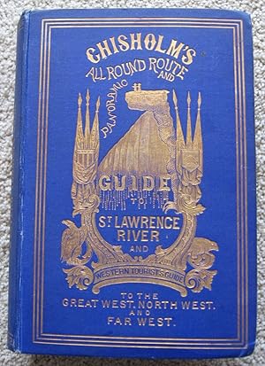
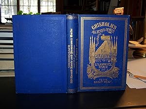
Hardcover. Condition: Very Good. q (illustrator). First Thus. 1st edition thus, greatly expanded from editions in the early 1870s that did not include the far West. 8vo royal blue cloth with heavy gilt decorations & titles. xii, 556pp. Illustrated with engravings. Contents. Classified Index to Advertisers. Index of Cities, Towns and Places of Interest. Eight tipped in folding maps ("Saratoga", "Prospect Park, Niagara Falls", "Niagara Falls", "Caledonia Springs", "Lower St. Lawrence, and Saguenay River", "White Mountains", "City of Boston", Excursion Routes"). Also, a spectacularly long folding map in front pocket, extending to 11' 7", of the Niagara & St. Lawrence Rivers (it's called "Panorama of St. Lawrence River"). Advertisements before & after main text for several historical railroads & hotels of the NE and the West (includes the colorfully named Oregon railroad & steamship companies). One rather long tipped in fold out map has on its verso a great pictorial ad of the Chicago ,Rock Island, & Pacific RR Palace Dining car cross section showing travelers dining in luxury & leisure. The section on Chicago has many engravings, showing the great fire & the rebuilding of the city since. Includes Union Stockyards. The so-called "Western Appendix" to the book is 177pp. long, & begins with Chicago & goes to Kansas City, Omaha, Denver, Leavenworth, San Francisco, Sacramento, Oregon, & Victoria. Includes table of stations of the Union Pacific & Central Pacific railways. Most of the book is, of course, on the Niagara Falls & St. Lawrence area, with information on Toronto. The corner covers are bent at the tips & soft. Just a bit of fraying to the spine. Leading & trailing edges of the long map are have short tears & a touch of chipping. Verso of rear free endpaper is browned from prior lay-in. Slight cracking to rear hinge. The gilt is bold & beautiful, showing small shields of Canada & the U.S., & rising up between them a famous high cantilevered rock over Yosemite Valley with two people standing near the edge of it -- all in gilt! Gilt decorative devices of the U.S. eagle & the Canadian beaver. Front cover is bordered in gilt. The text pages (except for indexes & ads) are decoratively bordered in red. This item is one of the more interesting books I have had the privilege to offer for sale. Earlier editions are scarce. This greatly expanded edition is rare. Not in the usual Western bibs.
-
Chisholm's All Round Route And Panoramic Guide Of The St. Lawrence
Published by Montreal: Chisholm & Co., Printed By John Lovell, 1870., 1870
Seller: D & E LAKE LTD. (ABAC/ILAB), Toronto, ON, Canada
Seller rating 4 out of 5 stars
US$ 388.50
Convert currencyUS$ 15.00 shipping from Canada to U.S.A.Quantity: 1 available
Add to basket8vo. pp. 126, [46]ads. long folding panorama (frontis.), 2 folding maps, & numerous text illus. (some full-page). original gilt-stamped cloth (bit faded & worn, neat repairs to verso of maps, title chipped at upper edge & with strip clipped from lower blank margin). Including folding maps of the vicinity of Niagara Falls, and of the northeastern states and part of Ontario & Quebec showing excursion routes as well as the frequently wanting or defective 11 � foot long panorama of the St. Lawrence by Alfred E.Waud.
-

Chisholm's All Round Route and Panoramic Guide of the St. Lawrence
Seller: BuchWeltWeit Ludwig Meier e.K., Bergisch Gladbach, Germany
Seller rating 5 out of 5 stars
US$ 25.09
Convert currencyUS$ 26.80 shipping from Germany to U.S.A.Quantity: 2 available
Add to basketTaschenbuch. Condition: Neu. This item is printed on demand - it takes 3-4 days longer - Neuware -Chisholm's All Round Route and Panoramic Guide of the St. Lawrence is an unchanged, high-quality reprint of the original edition of 1870.Hans Elektronisches Buch is editor of the literature on different topic areas such as research and science, travel and expeditions, cooking and nutrition, medicine, and other genres. As a publisher we focus on the preservation of historical literature. Many works of historical writers and scientists are available today as antiques only. Hans Elektronisches Buch newly publishes these books and contributes to the preservation of literature which has become rare and historical knowledge for the future. 220 pp. Englisch.
-
US$ 34.04
Convert currencyFree shipping from India to U.S.A.Quantity: Over 20 available
Add to basketLeather Bound. Condition: New. Language: English. Presenting an Exquisite Leather-Bound Edition, expertly crafted with Original Natural Leather that gracefully adorns the spine and corners. The allure continues with Golden Leaf Printing that adds a touch of elegance, while Hand Embossing on the rounded spine lends an artistic flair. This masterpiece has been meticulously reprinted in 2025, utilizing the invaluable guidance of the original edition published many years ago in 1870. The contents of this book are presented in classic black and white. Its durability is ensured through a meticulous sewing binding technique, enhancing its longevity. Imprinted on top-tier quality paper. A team of professionals has expertly processed each page, delicately preserving its content without alteration. Due to the vintage nature of these books, every page has been manually restored for legibility. However, in certain instances, occasional blurriness, missing segments, or faint black spots might persist. We sincerely hope for your understanding of the challenges we faced with these books. Recognizing their significance for readers seeking insight into our historical treasure, we've diligently restored and reissued them. Our intention is to offer this valuable resource once again. We eagerly await your feedback, hoping that you'll find it appealing and will generously share your thoughts and recommendations. Lang: - English, Pages:- 188, Print on Demand. If it is a multi-volume set, then it is only a single volume. We are specialised in Customisation of books, if you wish to opt different color leather binding, you may contact us. This service is chargeable. Product Disclaimer: Kindly be informed that, owing to the inherent nature of leather as a natural material, minor discolorations or textural variations may be perceptible. Explore the FOLIO EDITION (12x19 Inches): Available Upon Request. 188.
-

Chisholm's All Round Route and Panoramic Guide of the St. Lawrence
Seller: buchversandmimpf2000, Emtmannsberg, BAYE, Germany
Seller rating 5 out of 5 stars
US$ 25.09
Convert currencyUS$ 69.91 shipping from Germany to U.S.A.Quantity: 1 available
Add to basketTaschenbuch. Condition: Neu. This item is printed on demand - Print on Demand Titel. Neuware -Chisholm's All Round Route and Panoramic Guide of the St. Lawrence is an unchanged, high-quality reprint of the original edition of 1870.Hans Elektronisches Buch is editor of the literature on different topic areas such as research and science, travel and expeditions, cooking and nutrition, medicine, and other genres. As a publisher we focus on the preservation of historical literature. Many works of historical writers and scientists are available today as antiques only. Hans Elektronisches Buch newly publishes these books and contributes to the preservation of literature which has become rare and historical knowledge for the future.Books on Demand GmbH, �berseering 33, 22297 Hamburg 220 pp. Englisch.
-

US$ 25.09
Convert currencyUS$ 71.91 shipping from Germany to U.S.A.Quantity: 1 available
Add to basketTaschenbuch. Condition: Neu. nach der Bestellung gedruckt Neuware - Printed after ordering - Chisholm's All Round Route and Panoramic Guide of the St. Lawrence is an unchanged, high-quality reprint of the original edition of 1870.Hans Elektronisches Buch is editor of the literature on different topic areas such as research and science, travel and expeditions, cooking and nutrition, medicine, and other genres. As a publisher we focus on the preservation of historical literature. Many works of historical writers and scientists are available today as antiques only. Hans Elektronisches Buch newly publishes these books and contributes to the preservation of literature which has become rare and historical knowledge for the future.

![Seller image for CHISHOLM'S ALL-ROUND ROUTE AND PANORAMIC GUIDE OF THE ST. LAWRENCE : [etc.] and WESTERN TOURISTS' GUIDE TO THE GREAT WEST, NORTH WEST AND FAR WEST, [etc.] for sale by Aardvark Rare Books, ABAA](https://pictures.abebooks.com/inventory/md/md31944842020.jpg)


![Seller image for Chisholm's all round route and panoramic guide of the St. Lawrence, the Hudson River, Trenton Falls, Niagara, Toronto, the Thousand Islands and the River St. Lawrence, Ottawa, Montreal, Quebec, the Lower St. Lawrence and the Saguenay Rivers, the White Mountains, Portland, Boston, New York 1870 [Leather Bound] for sale by Gyan Books Pvt. Ltd.](https://pictures.abebooks.com/inventory/md/md30265006104.jpg)