Order Total (1 Item Items):
Shipping Destination:

Comic Map Europe (6 results)
Skip to main search results
Search filters
Product Type
- All Product Types
- Books (3)
- Magazines & Periodicals (No further results match this refinement)
- Comics (No further results match this refinement)
- Sheet Music (No further results match this refinement)
- Art, Prints & Posters (No further results match this refinement)
- Photographs (No further results match this refinement)
- Maps (3)
- Manuscripts & Paper Collectibles (No further results match this refinement)
Condition Learn more
- New (No further results match this refinement)
- As New, Fine or Near Fine (No further results match this refinement)
- Very Good or Good (No further results match this refinement)
- Fair or Poor (No further results match this refinement)
- As Described (6)
Binding
- All Bindings
- Hardcover (No further results match this refinement)
- Softcover (1)
Collectible Attributes
- First Edition (No further results match this refinement)
- Signed (No further results match this refinement)
- Dust Jacket (No further results match this refinement)
- Seller-Supplied Images (6)
- Not Print on Demand (6)
Language (1)
Price
- Any Price
- Under US$ 25 (No further results match this refinement)
- US$ 25 to US$ 50 (No further results match this refinement)
- Over US$ 50
Free Shipping
Seller Location
Seller Rating
-

Comic Map of Europe.
Published by [London, c.1870.]. 165 x 240mm (6½ x 9½ inches)., 1870
Seller: Tooley, Adams & Co., Wallingford, OXON, United Kingdom
Seller rating 3 out of 5 stars

US$ 525.47
US$ 49.88 shipping
Ships from United Kingdom to U.S.A.Quantity: 1 available
Add to basketHand coloured lithograph; very light soling, otherwise fine condition. A satirical map of Europe, the original artist is not credited here, although it is after Paul Hadol. The name C. Hentschel Sc appears in the bottom left corner. Published in magazines throughout Europe, this one appears to be from a London production by H.C. Panzer, it was also published in Paris by Vallée as Nouvelle carte d'Europe dressée pour 1870. The text below reads: England enraged forgets Ireland but still keeps it in her power. Spain & Portugal smoke away lazily. France tries to overthrow Prussia who advances one hand on Holland & knee over Austria. Italy advises Bismark to keep off. Corsica & Sardinia laugh on at all. Denmark hopes to recover Holstein. Turkey is drowsily awaking from smoke. Sweden crouching like a panther. Russia a beggar trying for anything to fill his basket. Published at around the time of the Franco - Prussian war. On 16 July 1870, the French parliament voted to declare war on Prussia, hostilities began three days later when French forces invaded German territory. This resulted in retaliation and France was eventually defeated in May 1871 by the Kingdom of Prussia and other German states. The end of the war led to the unification of Germany. Otto von Bismarck annexed Alsace and northern Lorraine to the new German Empire in 1871.
-

John Bull and his Friends. A Serio-Comic Map of Europe. By Fred. W. Rose, Author of "Angling in Troubled Waters" &c. &c. 1900.
Published by London, G.W. Bacon, 1900. 490 x 695mm (19¼ x 27¼ inches)., 1900
Seller: Tooley, Adams & Co., Wallingford, OXON, United Kingdom
Seller rating 3 out of 5 stars
US$ 6,222.64
US$ 49.88 shipping
Ships from United Kingdom to U.S.A.Quantity: 1 available
Add to basketOriginal coloured chromolithograph; signs of light wear at folds, small holes at intersections, expertly backed on archivist tissue and retaining the original printed card wrapper, overall very good condition. One of the most sought after "Octopus" maps showing Europe, the countries are made up of caricatures of the people of each country. It highlights the political insecurities of the period, as explained by the text on the left. The main worry being the large Russian octopus displaying the face of Tsar Nicolas II, its tentacles reaching out to the throats of Poland, Persia and China, one grabbing for Turkey's foot and another laid across Finland. England and Scotland are depicted as a soldier in service dress of the Boer War, waving a Union Flag, with two wildcats marked 'Orange Free State' and 'Transvaal' savaging his legs. He sits on shells marked with their destinations: Canada, Australia, South Africa and India. Whilst Ireland 'vents her anger' on him. France beckons Germany to help her against Britain who she blames for her colonial upsets, and Italy stretches out a helping hand. Spain is mourning the recent loss of Cuba and the Philippines, her last important colonial possessions.
-
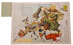
Angling in Troubled Waters Der Fischfang im Trüben - La Pêche en l'eau trouble - La Pesca nelle acque turbes. A Serio-Comic Map of Europe By Fred W. Rose. Author of the "Octopus" map of Europe.
Seller: Herman H. J. Lynge & Søn ILAB-ABF, Copenhagen, Denmark
Seller rating 4 out of 5 stars

London, Bacon & Co. Ltd., 1899. Chromlithographed folded map (50 x 71 cm) in original printed covers (20 x 14 cm). 5 cm tear in horisontal fold in left margin. 10 cm long tear in spine of cover, but map and wrappers still firmly attached, otherwise a fine copy. A fine copy of Frederick Rose?s famous caricature map of Europe with each country depicted as an angler having various levels of success in catches colonies. Serving as an allegory for European colonial interference elsewhere, this type of map influenced and reflected popular opinion, much like a political cartoon. Political boundaries and power struggles define this work. The 19th-century ?serio-comic map? caricaturizes each European country as a fisherman, holding a sack with its imperial catch, or about to lose what it has caught. Serving as an allegory for European colonial interference elsewhere, this type of ?persuasive? map influenced and reflected popular opinion, much like a political cartoon. Despite the popularity of his posters and a considerable output, there has been some controversy regarding Frederick Rose?s exact identity, in part due to his common name. Recent research suggest that Rose was of honorable Scottish descent and spent most of his professional life working as a civil-servant at Somerset House in London (Inland Revenue at the time).
-

Angling in Troubled Waters Der Fischfang im Trüben - La Pêche en l'eau trouble - La Pesca nelle acque turbes. A Serio-Comic Map of Europe By Fred W. Rose. Author of the "Octopus" map of Europe Copyright - Tous Droits Réservés 1899. 15th Thousand.
Published by G. W. Bacon & Co. Ltd., 127 Strand,, London,, 1899
Seller: Daniel Crouch Rare Books Ltd, London, United Kingdom
Association Member: ABA ILAB PBFA
Seller rating 4 out of 5 stars
Map
US$ 6,222.64
US$ 26.85 shipping
Ships from United Kingdom to U.S.A.Quantity: 1 available
Add to basketTsar Nicholas II puppet master Chromlithograph map, inset map of Europe upper right, key to map lower right and left, folding into original paper covers, one cover detached, with publisher's label. A caricature map of Europe with each country depicted as an angler having various levels of success in hooking colonies: John Bull has a huge catch-bag (Ireland), with Egypt as a crocodile on the end of his line; France is a scuffle for control of the Third Republic between the military and civilian, their rod with an empty hook, with Napoleon's shade looking on from Corsica; Spain is watching sadly as their former catch (fish marked Cuba, Porto Rico and Phillippines) is being dragged away on the lines of an unseen U.S.A.; Belgium has the Congo; the Austro-Hungarians are mourning the assassination of Empress Elisabeth by an anarchist; Turkey has a hook in 'the Cretan spike fish', and a stain on his trousers is a skull marked 'Armenia'; Greece has pricked a finger trying to catch the spike fish by hand; larger than all others is Russia, shown as Nicholas II with an olive branch in one hand and a line stretching to the Far East in the other. Hill, Cartographical Curiosities, 57; MCC 1, Geographical Oddities, no 82.
-

Serio-comic map of Europe - Fritz Elsner, 1914
Seller: Inter-Antiquariaat Mefferdt & De Jonge, Amsterdam, Netherlands
Seller rating 3 out of 5 stars
Map
US$ 1,165.94
US$ 48.76 shipping
Ships from Netherlands to U.S.A.Quantity: 1 available
Add to basketWWI PROPAGANDA MAP OF EUROPE "Karikatur des deutschen Kriegsschauplatzes" [Charicature of the German theatre of war]. Lithograph in colour made by Fritz Elsner in 1914, published in Cologne by F. Klotz and G. Cremer. With collector's stamp of Martinus Cornelis Sigal (1888 - 1969). Size (paper): 40 x 50 cm. While the soldiers of World War I fought on various fronts across Europe, artists and governmental departments on the home front engaged intheir own propaganda battle via posters, postcards, and patriotic memorabilia. Maps with propaganda elements were very popular. They were meant to convince the public of an enemy's evil tendencies, or that a conflict is winnable and worth the sacrifice. During the war, on both sides of the front, they were distributed as agitation material that attempted to raise the fighting spirit of both soldiers and the population at home. They were generally sold separately, and due to their ephemeral nature quite rare. The German text below the map not so subtly explains about the various nations in this theatre of war [please forgive the translator for not finding words that rhyme]: Germany: Bring it on! Lots of enemy, lots of honour! France: What do you think, you pre-Roman cock, That started with a chest full of hate, You wanted to devour Germany, No way, that you will succeed! Belgium: You foolish country, you should have made up your mind earlier, You should have made room for the Germans, How different would things be for you now, You would have saved lots of blood and money. Russia: You thought you would sack with ese, These German warriors, But instead the Russian bear, Gets beaten with a wedge, more and more. England: You double tongued boy, You wanted to hide, Zeppelin will wake you up. Serbia: You, the origin of this conspiracy, The German wave will not spare you, you terrible wretch, Remember this and don't forget, You and all the other sheep thieves, This will cost you German lashes. Price: Euro 975,-.
-

serio-comic map Europe 1870 - Charles Fuchs after Paul Hadol
Seller: Inter-Antiquariaat Mefferdt & De Jonge, Amsterdam, Netherlands
Seller rating 3 out of 5 stars
Map
US$ 1,494.79
US$ 48.76 shipping
Ships from Netherlands to U.S.A.Quantity: 1 available
Add to basketKarte von Europa im Jahre 1870". Lithograph published by Charles Fuchs in Hamburg in 1914. Size: 36,4 x 47,5 cm. Nice example of the German edition of Paul Hadol's satirical political cartoon map ("carte drôlatique") of Europe showing countries personified in caricature and alluding to the tensions that finally erupted as the Franco-Prussian War in July 1870. In the center, a buffoonish Prussia interacts with its suspicious neighbours. England is depicted as an old woman holding its dog, Ireland, by a leash. Spain and Turkey are portrayed as unconcerned women on the fringes relaxing with a cigarette and a hookah respectively. Corsica and Sardinia become an impish figure mooning the viewer. A rifle with a bayonet near the bottom edge is sardonically labeled "Degrees of Longitude." The various tensions and rivalries between the nations are described in the caption: "England enraged forgets Ireland but still keeps it in her power. Spain & Portugal smoke away lazily. France tries to overthrow Prussia who advances one hand on Holland and one over Austria. Italy advises Bismarck to keep off. Corsica & Sardinia laugh on at all. Denmark hopes to recover Holstein. European Turkey awakens yawningly. Asian Turkey is inhaling the smoke of a waterpipe. Sweden crouching like a panther. Russia as Servant Rupert is trying for anything to fill his basket". Provenance: collection Martinus Cornelis Sigal (1888 - 1969), with collector's stamp on verso. Price: Euro 1.250,-.