Order Total (1 Item Items):
Shipping Destination:

Cusco: Maps, Art, Prints, & Posters (31 results)
Feedback
Title:
cusco
Edit in Advanced Search
Skip to main search results
Search filters
Product Type
- All Product Types
- Books (1,269)
- Magazines & Periodicals (1)
- Comics (No further results match this refinement)
- Sheet Music (1)
- Art, Prints & Posters (20)
- Photographs (2)
- Maps (11)
- Manuscripts & Paper Collectibles (28)
Condition Learn more
- New (No further results match this refinement)
- As New, Fine or Near Fine (5)
- Very Good or Good (8)
- Fair or Poor (1)
- As Described (17)
Binding
- All Bindings
- Hardcover (No further results match this refinement)
- Softcover (1)
Collectible Attributes
- First Edition (2)
- Signed (No further results match this refinement)
- Dust Jacket (No further results match this refinement)
- Seller-Supplied Images (29)
- Not Print on Demand (31)
Language (5)
Free Shipping
Seller Location
Seller Rating
-

US$ 10.74
Convert currencyUS$ 9.85 shipping from Italy to U.S.A.Quantity: 1 available
Add to basketCondition: Ottimo. Rara stampa Estratta da pubblicazione del 1990 Carta geografica o mappa La mappa di Cusco del 1572, realizzata da Georg Braun e Frans Hogenberg, fa parte del celebre atlante Civitates Orbis Terrarum, una raccolta di vedute urbane pubblicata tra il 1572 e il 1617. Questa rappresentazione di Cusco, capitale dell'Impero Inca, � una delle poche vedute americane incluse nell'opera. La citt� � raffigurata con dettagli architettonici e paesaggistici, mostrando la sua struttura organizzata e le fortificazioni. In primo piano si vede il sovrano inca trasportato su una portantina, circondato da nobili e soldati. Dimensioni Cm 26,00 x 29,00 Codice prodotto VIP-241 PayPal Carta di credito Bonifico bancario Inserita dentro plico di adeguate dimensioni per proteggerne l'integrit� Spedizione con posta ordinaria o raccomandata scelta dall'Acquirente nel momento del pagamento Clicca qui per accedere al nostro Store ed al suo sterminato archivio VIP-241_01.
-

US$ 29.83
Convert currencyUS$ 6.95 shipping from Germany to U.S.A.Quantity: 1 available
Add to basketKein Einband. Condition: Gut. Original engraving from Bellin. Published in Histoire generale de voyages. Paris, from 1745 to 1779. Sheetsize: each sheet approx 22 x 17 cm. Condition: please see photo.
-

"Temple du Soleil a Cusco" - Cusco Peru sun temple South America Amerika Amerique temple plan Tempel engraving grabado
Published by Paris, 1750
Language: French
Seller: Antiquariat Steffen V�lkel GmbH, Seubersdorf, Germany
Seller rating 5 out of 5 stars

Art / Print / Poster
US$ 17.89
Convert currencyUS$ 37.07 shipping from Germany to U.S.A.Quantity: 1 available
Add to basketOriginalKupferstich von ca. 1750. -- Blattmasse: ca. 25 x 19 cm. -- im Au�enrand teils leicht fleckig, sonst gut erhalten. || Original copper engraving from circa 1750. -- slightly stained on the outer margin, otherwise in good condition. || Dies ist ein Original! - Kein Nachdruck! - Keine Kopie! -- This is an original! - No copy! - No reprint! Sprache: Franz�sisch Gewicht in Gramm: 550.
-

Plan of Cusco, Peru
Published by Paris, 1746
Seller: Trillium Antique Prints & Rare Books, Franklin, TN, U.S.A.
Seller rating 4 out of 5 stars

Art / Print / Poster
Condition: Fine. This fine engraving is from Antoine-Francois Prevost d'Exiles's Histoire G� n� rale des Voyages, ou nouvelle collection de toutes les relations de voyages par mer et par terre, qui ont � t� publi� es jusqu'� present dans les diff� rentes langues de toutes les nations connues. The work was published by Chez Didot in Paris in 1746. The plates and maps were by Cochin fils, Tardieu, B. L. Prevost and others.It was an expansive work that referenced China, the East Indies, Asia, the Americas, early Austrlian voyages, New Guinea, Palau Islands, Africa, and voyages in the Pacific including those of Magellan, Schouten, and Le Maire, Drake, Sarmiento, Cavendish, Spilbergen, Narborough, Rogers, Cowley, Frazier, and Anson. The work included particularly full accounts are given of the Dutch and French voyages to the East Indies, voyages to China, and the British East India Company's voyages to India and Ceylon. (Hill) --- Overall Very Good to Excellent. There can be some very light image or text offset with this work. There may be a few minor imperfections to be expected with age. Please review the image carefully for condition and contact with any questions.
-

1894 Antique Print of The Cusco Cathedral in Peru
Published by Reclus
Seller: Artisans-lane Maps & Prints, Victoria, BC, Canada
Seller rating 5 out of 5 stars
Art / Print / Poster
US$ 37.40
Convert currencyUS$ 9.50 shipping from Canada to U.S.A.Quantity: 1 available
Add to basketno binding. Condition: very good. The Cusco Cathedral, also known as the Cathedral Basilica of the Assumption of the Virgin, is a significant religious and historical landmark located in the city of Cusco, Peru. Image Size: 7 1/2 x 5 ins. Overall Size including text and borders : 10 1/2 x 7 Ins. CONDITION: Full page print. Blank on the back. Clear and sharp with beautiful detail. As scanned. This beautiful print would look great matted and framed. Or an art supply store can provide you with a selection of frames for old art treasures. NOTE THE FOLLOWING BEFORE YOU PURCHASE: This is a GENUINE ANTIQUE VINTAGE 1880s PRINT. It is NOT a modern reproduction, ie. a laser scan, photocopy, etc. It is the original from the antique or vintage atlas or book publication. This print was published on the date mentioned, or circa the date mentioned at the top of the page. The print I have for sale, like many antique vintage prints and maps that you see online, originate from an antique vintage book or atlas publication. The publication may not always be known. If you have any questions, emails are welcome. FRAME IS FOR DISPLAY PURPOSES ONLY AND NOT INCLUDED IN THE PURCHASE.
-

"Cusco." - Cusco Cuzco Peru South America S�damerika
Published by Frankfurt, 1719
Language: French
Seller: Antiquariat Steffen V�lkel GmbH, Seubersdorf, Germany
Seller rating 5 out of 5 stars
Art / Print / Poster
US$ 35.78
Convert currencyUS$ 37.07 shipping from Germany to U.S.A.Quantity: 1 available
Add to basketOriginal Kupferstich von Alain Manesson Mallet (1630-1706) von 1719. -- Blatt-Ma�e: ca. 20 x 15,5 cm. -- etwas fleckig, sonst gut erhalten. || Original copper engraving by Alain Manesson Mallet (1630-1706) from 1719. -- with some staining, otherwise in good condition. || Dies ist ein Original! - Kein Nachdruck! - Keine Kopie! -- This is an original! No copy! - No reprint! Sprache: Franz�sisch Gewicht in Gramm: 10.
-

"Cusco." - Cusco Cuzco Peru South America S�damerika
Published by Paris, 1683
Language: French
Seller: Antiquariat Steffen V�lkel GmbH, Seubersdorf, Germany
Seller rating 5 out of 5 stars
Art / Print / Poster
US$ 35.78
Convert currencyUS$ 37.07 shipping from Germany to U.S.A.Quantity: 1 available
Add to basketOriginal Kupferstich von Alain Manesson Mallet (1630-1706) aus "Description de l'Univers. Vol V." von 1683. -- Mit Text auf der R�ckseite. -- Blatt-Ma�e: ca. 21,5 x 14 cm. -- gut erhalten. || Original copper engraving by Alain Manesson Mallet (1630-1706) out of "Description de l'Univers. Vol V." from 1683. -- With text on verso. -- in good condition. || Dies ist ein Original! - Kein Nachdruck! - Keine Kopie! -- This is an original! No copy! - No reprint! Sprache: Franz�sisch Gewicht in Gramm: 10.
-
![Seller image for Temple du Soleil � Cusco [Temple of the Sun at Cusco] for sale by Antiqua Print Gallery](https://pictures.abebooks.com/inventory/md/md31688974835.jpg)
US$ 34.24
Convert currencyUS$ 13.30 shipping from United Kingdom to U.S.A.Quantity: 1 available
Add to basketCondition: Good. 'Temple du Soleil � Cusco'. Coricancha. Temple of the Sun at Cusco, Peru 1756. Antique copperplate print; E Hauhard sculp (1756). 19.0 x 14.5cm, 7.5 x 5.75 inches. Condition: Good. The image shown may have been taken from a different example of this print than that which is offered for sale. The print you will receive is in good condition but there may be minor variations in the condition from that shown in the image. There is nothing printed on the reverse side, which is plain.
-
US$ 58.90
Convert currencyUS$ 13.30 shipping from United Kingdom to U.S.A.Quantity: 2 available
Add to basketCondition: Good. 'Plan de Cusco'. City plan of Cusco, Peru. BELLIN 1756 old antique map chart. Antique copperplate map; Unsigned (1756). 20.5 x 16.5cm, 8 x 6.5 inches. Condition: Good. The image shown may have been taken from a different example of this map than that which is offered for sale. The map you will receive is in good condition but there may be minor variations in the condition from that shown in the image. There is nothing printed on the reverse side, which is plain.
-
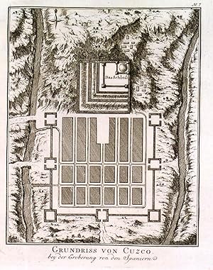
'GRUNDRISS VON CUZCO'. Plan of Cusco in Peru. Engraved by
Published by Nicolas Bellin ca. 1750, 1750
Map
US$ 54.79
Convert currencyUS$ 53.19 shipping from United Kingdom to U.S.A.Quantity: 1 available
Add to basketCondition: Fine. 18x14cm. Excellent condition.
-

Cusco / die Stadt Cusco. Kupferstich aus A. M. Mallet "Beschreibung Des gantzen Welt-Kreises" Frankfurt, J. A. Jung 1719, 14,2 x 10 cm
Seller: Antiquariat Johannes M�ller, Salzburg, Austria
Seller rating 5 out of 5 stars
Art / Print / Poster
US$ 59.66
Convert currencyUS$ 25.48 shipping from Austria to U.S.A.Quantity: 1 available
Add to basketFig. 49.- Alain Manesson Mallet (* 1630 in Paris; ? 1706 ebenda) war ein franz�sischer Kartograph und Ingenieur. Sein Hauptwerk "Description de L'Univers" erschien erstmals 1683 in f�nf B�nden in Paris.- R�nder leicht fleckig. Sch�nes, breitrandiges Exemplar, ohne Text auf der R�ckseite. # Bird`s eye view of the city of Cuzco.- Nice, wide-margined copy from the second, revised German edition of Mallet's "Description de l'Univers" with additional German title on top; without text on the back.
-
[3 adjacent sheets] Soviet General Staff General Terrain Evaluation Maps D-19 Cuzco / Cusco; E-19 La Paz; E-20 Santa Cruz 1:1,000,000 (Bolivia, Peru, Chile, Brazil, Paraguay)
Published by General Staff of the Armed Forces of the USSR, Moscow, 1979
Language: Russian
Map
US$ 68.48
Convert currencyUS$ 33.24 shipping from United Kingdom to U.S.A.Quantity: 1 available
Add to basketNo Binding. Condition: Very Good. Three adjacent sheets, colour printed on paper 74x58, 70x60, 79x60cm, labelled in the Cyrillic alphabet, compiled 1978-9, and published 1979. Very good, folded, lightly creased. Two key diagrams locate each sheet, and demarcate administrative divisions. These were issued as part of the major global mapping programme by the Military Topographic Directorate of the General Staff of the Armed Forces of the USSR, during 1950-90. Maps comply with International Map of the World standards, with each quadrangle on a 1:1,000,000 scale identified by lettered bands and numbered zones. Sources are not named, but for the wider series included a mix of existing maps and guidebooks, the Zenit Satellite Programme (from the 1960s), and "boots on the ground". (Reference: Davies & Kent, The Red Atlas, 2017).
-
Il Cusco Citta Principale Della Provincia Del Peru. / Die Statt Cusco / in dem K�nigreich Peru in West Indien.
Published by BasleHenricpetri., 1628
Seller: Robert Frew Ltd. ABA ILAB, London, United Kingdom
Association Member: ABA ILAB PBFA
Seller rating 4 out of 5 stars
Map
US$ 171.21
Convert currencyUS$ 13.30 shipping from United Kingdom to U.S.A.Quantity: 1 available
Add to basket26.9 x 37.5 cm. Uncoloured. Double page woodcut view of Cusco from a German text edition of Munster's Cosmographia. Headpiece and alternative title on verso of left page, showing through to recto. Text on verso of right page. A few expert repairs to extremities of margins, otherwise in good condition.
-

Battle of Cusco Eroberung - 14. Nov. 1533 (262) / Peru Inka Inca Empire South America Amerika Amerique / (Historia Antipodum oder Newe Welt und Americanische Historien)
Published by Frankfurt am Main, Merian, 1631
Language: German
Seller: Antiquariat Steffen V�lkel GmbH, Seubersdorf, Germany
Seller rating 5 out of 5 stars
Art / Print / Poster First Edition
US$ 83.51
Convert currencyUS$ 37.07 shipping from Germany to U.S.A.Quantity: 1 available
Add to basketOriginal Kupferstich auf vollem Textblatt. Vor- und R�ckseite bedruckt. -- Blatt-Ma�e: ca. 36 x 22 cm. -- gut erhalten. || Original copper engraving; on the complete text page. Printed on recto and verso. -- in good condition. || This engraving comes from "Newe Welt und Americanische Historien.", a richly illustrated travel account by Johann Ludwig Gottfried. This particular piece is from the first edition, published in Frankfurt am Main in 1631 by the renowned published and engraver Matthaeus Merian. The work played a significant role in shaping European perceptions of the Americas, offering detailed descriptions of the landscapes, islands, kingdoms, provinces, and coastlines of the New World. Johann Ludwig Gottfried (1584-1633), a German publisher, took over the publishing house of Theodor de Bry and later issued this work. De Bry had originally obtained artwork and accounts from both French and English colonial expeditions in the late 16th century. Artists such as Jacques Le Moyne de Morgues and John White documented their experiences, and de Bry transformed their illustrations into copperplate engravings. Gottfried continued this legacy, incorporating these engravings along with new illustrations based on textual descriptionssometimes leading to the inclusion of fantastical elements like mermaids and dragons. Merian also contributed by re-engraving or replacing plates that had worn over time, while Gottfried oversaw the editing and translation. Scholar Borba de Moraes described this work as an "important and magnificent work" that remains highly sought after, rare, and valuable. Historian Michiel van Groesen further praised it in "America Abridged", by calling it "the apotheosis of the collection of voyages to the New World." || Sprache: Deutsch Gewicht in Gramm: 10.
-

Description & plant de la Cite de Cusco, ville capitale du Royaume de Peru & la maniere de viure des habitans d\'icelle
Published by circa. 1560, Paris, 1560
Seller: Alexandre Antique Prints, Maps & Books, Toronto, ON, Canada
Seller rating 5 out of 5 stars
Map
US$ 275.00
Convert currencyUS$ 6.00 shipping from Canada to U.S.A.Quantity: 1 available
Add to basketThe Cosmographia by Sebastian M�nster (1488 ? 1552) from 1544 is the earliest German description of the world. It had numerous editions in different languages including Latin, French (translated by Fran�ois de Belleforest), Italian, English, and even Czech. The last German edition was published in 1628, long after his death. The Cosmographia was one of the most successful and popular books of the 16th century. It passed through 24 editions in 100 years. This success was due to the fascinating woodcuts (some by Hans Holbein the Younger, Urs Graf, Hans Rudolph Manuel Deutsch, and David Kandel). It was most important in reviving geography in 16th century Europe. Text in French, Size : 125x155 (mm), 4.875x6.125 (Inches), Hand Colored Excellent; very faint waterstain on upper right hand corner.
-

View of Cuzco (Cusco), Peru
Published by Amsterdam, 1671
Seller: Trillium Antique Prints & Rare Books, Franklin, TN, U.S.A.
Seller rating 4 out of 5 stars
Art / Print / Poster First Edition
Condition: Fine. This first edition, early Americana engraving is from Arnoldus Montanus's De Nieuwe en Onbekende Weereld (Dutch) or The New and Unknown World (English). The work was published in Amsterdam in 1671 by Jacob Meurs. This being a first edition work is important as the impressions from the plates are strongest in this issue.The work is "a classic book on America and is much sought after by collectors of Americana" (Borba de Moraes). It contains one of the first views of New York: "without any doubt, the handsomest, and� the most agreeable view of Dutch New York� (Asher's Bibliographical Essay, p.23). The work was done at the height of European fascination with the New World. It featured illustrations of customs, festivals, occupations, religious rites and battles of the native Indians. It is considered one of the most interesting iconographic and cartographic sources of early Americana.Arnoldus Montanus was a Dutch writer, Protestant minister, and headmaster of a Latin School in Schoonhoven. He also published works on church history, theology, the Low Countries, and the people and culture of the Americas. Montanus never actually travelled to the New World, and thus the work has numerous errors and artistic liberties based upon the European perception of the people and animals of the Americas. It still served as the standard work on the Americas for years to come.The North American section contains notable versions of the Blaeu map of New England and New Netherlands as well as versions of the John Smith Virginia and Carolina maps. It also contains one of the first engraved views of New York (the very first, the Van der Donck view, appeared twenty years earlier). There is also a detailed map of Bermuda, views in Mexico, the Caribbean, and Brazil. The work is also noted for its portrait of Jan Maurits, Prince of Nassau.The full English title of the work is The New and Unknown World: or Description of America and the Southland, Containing the Origin of the Americans and South-landers, remarkable voyages thither, Quality of the Shores, Islands, Cities, Fortresses, Towns, Temples, Mountains, Sources, Rivers, Houses, the nature of Beasts, Trees, Plants and foreign Crops, Religion and Manners, Miraculous Occurrences, Old and New Wars: Adorned with Illustrations drawn from the life in America, and described by Arnoldus Montanus. --- The work is in very good to excellent condition overall. There may be a few minor imperfections or faint marks to be expected with age. Please review the image carefully for condition and contact us with any questions. --- Paper Size ~ 17 3/8" by 15" (Fold Out).
-

Die Statt Cusco
Published by c.1588, Basle, 1588
Seller: Alexandre Antique Prints, Maps & Books, Toronto, ON, Canada
Seller rating 5 out of 5 stars
Art / Print / Poster
US$ 575.00
Convert currencyUS$ 6.00 shipping from Canada to U.S.A.Quantity: 1 available
Add to basketCondition: Very Good. A fine view of Cusco, Peru, during the late 16th century. The view details various buildings, the outer fortifications, and is embellished with houses outside of the city walls, and people traversing the roadways heading towards the city. German text on verso.Sebastian M�nster (1488 ? 1552) was a German cartographer, cosmographer, and a Christian Hebraist scholar. His work, the Cosmographia from 1544, was the earliest German description of the world. , Image Size : 273x375 (mm), 10.75x14.76 (Inches), Platemark Size : , Paper Size : 344x434 (mm), 13.54x17.09 (Inches), Hand Colored, Wood Engraving.
-

Cusco, regni Peru in novo orbe caput.
Published by Colonia,, 1574
Seller: libreria antiquaria perini Sas di Perini, Verona, VR, Italy
Seller rating 5 out of 5 stars
Art / Print / Poster
US$ 596.57
Convert currencyUS$ 46.34 shipping from Italy to U.S.A.Quantity: 1 available
Add to basketIncisione in rame di mm 275x240 su foglio di mm 370x260, tratta da "Civitates Orbis Terrarum", pietra miliare del vedutismo, pubblicata in anni differenti dal 1572 al 1615 ca. in 6 volumi. Bella veduta di Cuzco, capitale del regno inca in Per? In primo piano sono visibili una portantina recante il re inca attorniato da servi e soldati; sullo sfondo alcune alture peruviane. Georg Braun (1541-1622) � stato un erudito teologo che comp� numerosi viaggi per scopi religiosi e politici nei quali ebbe modo di raccogliere un vasto materiale antropologico e geografico. Franz Hogenberg (1540 ca - 1590 ca) fu un abile incisore fiammingo. Dopo aver collaborato con Ortelio per il "Theatrum Orbis Terrarum", bandito dai Paesi Bassi, si trasfer� a Colonia, dove continu� la sua attivit? di incisore. I due collaborarono per alcuni anni dando alla luce la loro pi? celebre opera, le "Civitates Orbis Terrarum". Ottimo esemplare con integrazione dei margini laterali e restauro di alcuni minimi forellini. Nr.cat: P6170032.
-

Cusco Peru Machu Picchu Inca
Published by Peru, 1950
Seller: AntikBar Original Vintage Posters, London, UK, United Kingdom
Seller rating 4 out of 5 stars
Art / Print / Poster
US$ 1,712.10
Convert currencyUS$ 39.89 shipping from United Kingdom to U.S.A.Quantity: 1 available
Add to basketSabino Springett (illustrator). Original vintage travel advertising poster for Cusco Peru published by the National Cooperation of Tourism in Peru featuring great illustration of two people in traditional colourful poncho clothing and hats with a llama behind them standing in front of an ancient historical stone wall with the hills of Macchu Picchu in the background and the stylised red title text below. Located in the Peruvian Andes and a popular tourist destination, Cusco / Cuzco was the capital of the Inca Empire from 1438-1533 until the Spanish Conquest, and is known for its Incan archaeological remains (the dry stone walls built by the Incas were fitted tightly together with no mortar, a strong method of construction that has ensured their survival through even earthquakes over the centuries) and Spanish colonial architecture, declared a UNESCO World Heritage Site in 1983 and the Historical Capital of Peru; the 15th century Inca citadel of Machu Picchu was declared a Peruvian Historic Sanctuary in 1981, a UNESCO World Heritage Site in 1983 and one of the new New Seven Wonders of the World in 2007. Artwork by the distinguished Peruvian artist Sabino Springett (1913-2006). Good condition, restored tears, restored paper losses in margins, light staining in margin, backed on linen. Size: 102x73cm.
-

"Cusco" - Cusco Cuzco Peru South America Amerika Amerique
Published by Amsterdam, 1671
Language: Latin
Seller: Antiquariat Steffen V�lkel GmbH, Seubersdorf, Germany
Seller rating 5 out of 5 stars
Art / Print / Poster
US$ 178.96
Convert currencyUS$ 37.07 shipping from Germany to U.S.A.Quantity: 1 available
Add to basketOriginal Kupferstich von 1671. -- Blatt-Ma�e: ca. 38 x 44 cm. -- gut erhalten. || Original copper engraving from 1671. -- in good condition. || Dies ist ein Original! - Kein Nachdruck! - Keine Kopie! -- This is an original! - No copy! - No reprint! la.
-
Plan de Cusco. (Plan der Hauptstadt der gleichnamigen Provinz in Peru / S�damerika / South America)
Seller: Antiquariat Martin Barbian & Grund GbR, Saarbruecken, Germany
Seller rating 5 out of 5 stars
Art / Print / Poster
US$ 71.59
Convert currencyUS$ 52.13 shipping from Germany to U.S.A.Quantity: 1 available
Add to basketKupferstich von N. Bellin, 1772, 18x14,5 cm *Auf Wunsch senden wir nat�rlich gerne ein Foto per e-mail zu.
-
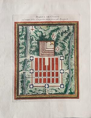
PIANTA DI CUSCO
Publication Date: 1764
Seller: LUX IN ART di Ermanno Bertelli, Bologna, BOLOG, Italy
Seller rating 5 out of 5 stars
Map
US$ 143.18
Convert currencyUS$ 48.65 shipping from Italy to U.S.A.Quantity: 1 available
Add to basketCondition: perfetta. Incisione in rame con coloritura d'epoca. Bella carta ritraente la pianta di Cusco. Tratta dall'atlante "Le petit atlas maritime", raccolta di carte e piante delle 4 parti del mondo. Bell'esemplare colorato, marginoso e in perfetto stato di conservazione. Formato: 230x175mm.
-

Cusco in West Indien.
Published by Daniel Meisner, 1630
Seller: Antiquariaat Dat Narrenschip, Middelburg, Netherlands
Seller rating 5 out of 5 stars
Map
US$ 214.77
Convert currencyUS$ 31.28 shipping from Netherlands to U.S.A.Quantity: 1 available
Add to basketNo Binding. Condition: Fine. Antique print of Cuzco. Bird's-eye view. Backside blank. Hand-coloured copper engraving, published in 1630 in "Thesaurus philopoliticus," by Daniel Meisner. Dimensions (image): 10 x 15 cm.
-

1550 Die Statt Cusco/so die fuernemeste im Landt Peru ist.
Seller: New World Cartographic, Chicago, IL, U.S.A.
Seller rating 1 out of 5 stars

Map
By: Sebastien M�nsterDate: 1550 (circa) BaselDimensions: 11.75 x 14.8 inches (29.85 x 37.6 cm)This splendid birds-eye-view of Cusco is one of the earliest maps of European origin of the city to become available, during the Age of Discovery.Highly detailed, the map depicts the ancient city while there were yet architectural vestiges of its Incan empire builders, for whom it had been the primary seat of government. The map appears to be based on the work of Venetian cartographer Benedetto Bordone, whose map was published in several editions.The foundations of the ancient Incan temple of the sun, called Qoricancha by its builders, can be seen beneath a large Spanish-built church, indicating that the map was drawn following the Spanish conquest of the Incan nation. Before its near destruction during the conquest, Qoricancha had been one of the one of the most beautiful and most sacred of all temples of the Incan empire.Pizarro described its exterior as being studded with gold plates with the temple's environs including convents and dormitories for priests. He went on to say that he and his compatriots were taken by surprise by the beauty and sophistication of Cusco, marveling that the stonework of its many palaces and other major edifices surpassed that of contemporary Spanish work. As in many European cities, foundations of earlier buildings were preserved and used as a base for construction of more modern structures, and many are visible to this day. The city is shown surrounded by huge crenellated walls, with towers at each corner and at midway between them, with gates in each allowing entrance to the city. Small vignettes depict both scantily clad indigenous people and European-clad individuals, replete with armor and plumed helmets.Following the plundering and rebuilding of the city, it soon became an important mercantile center, as well as becoming the major center for Spanish colonization and spread of Christianity in the Andean world. Its prosperity was due to local agriculture, animal husbandry, and mining, with its prosperity thanks to agriculture, cattle raising and mining. Colonists, primarily from Spain, constructed churches and convents, a cathedral and archdiocese, and a university.The Verso: Map of Tenochtitlan and its Influence on Venetian ExplorersThe verso depicts Tenochtitlan, the miraculous (to the Spanish) city in the middle of a lake, now known as Mexico City, on one side and on the other is the title page for the map of Cusco. The earliest known Europeans to visit Tenochtitlan were enthralled by the city, comparing it to Venice, with some even saying it outshone its Italian counterpart with its magnificence.The comparison led Venetian explorers and travelers to become interested in the wealthy city and its treasures. Venetian cartographers were intrigued by the wealth and sophistication of the city and some of their early maps depict the city as it was before being virtually razed by Spanish conquistadores led by Hern�n Cort�s. This map depicts a combination of vestiges of the ancient city along with European-inspired architectural edifices which would have been built during the reconstruction of the city. Condition: Map is in B+ condition in its original, uncolored state with a few faint areas of foxing but no holes and one marginal tear that has been mended on the verso. Margins are full on all sides and the verso provides a clean map of Tenochtitlan.Inventory #126741200 West 35th Street, #425, Chicago, IL 60609| Phone: (312) 496 - 3622.
-
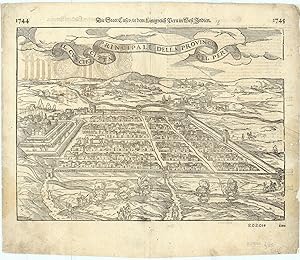
C. 1572 Georg Braun & Frans Hogenberg Map-View Of Cusco, Peru Rare 11.25 x 9.5"
Publication Date: 1572
Seller: ROBIN RARE BOOKS at the Midtown Scholar, Harrisburg, PA, U.S.A.
Seller rating 5 out of 5 stars
Art / Print / Poster
No Binding. Condition: Fair. No Jacket. Cusco Regni Peru In Novo Orme Caput. Extremely rare 1572 map-view of the Incan capital of Cuzco, Peru by Georg Braun and Fran Hogenberg. Hand-colored illustration likely taken from the Civitates Orbis Terrarum, with text on the reverse side. Illustration measures approximately 11.25 x 9.5". In fair condition, with slight rips and tears to edges. Mostly unnoticeable 2-inch tear towards the top right corner. Slight staining to some parts of the edges, with the remnants of tape affixed to the reverse side. Please see photos and ask any questions prior to purchasing. Despite the wear, this is still an extremely scarce map and piece of history, created less than 40 years after the Spanish conquest of Cuzco and around the same time that the last elements of the Incan Empire were defeated. George Braun (1541-1642) and Frans Hogenberg (1535-1590) were both influential European mapmakers and painters who helped compile early atlases and maps.
-
![Seller image for Il Cuscho citta Principale della Provincia del Peru - Effigies illustris civitatis Cusco quae est in regno Peruviae primaria existit [The city of Cusco] for sale by Antiqua Print Gallery](https://pictures.abebooks.com/inventory/md/md31896212517.jpg)
Il Cuscho citta Principale della Provincia del Peru - Effigies illustris civitatis Cusco quae est in regno Peruviae primaria existit [The city of Cusco]
Publication Date: 1572
Art / Print / Poster
US$ 520.48
Convert currencyUS$ 13.30 shipping from United Kingdom to U.S.A.Quantity: 1 available
Add to basketCondition: Good. Il Cuscho citta Principale della Provincia del Peru. City of Cusco. M�NSTER 1572. Antique 16th century woodcut print; Sebastian M�nster (1572). 30.0 x 38.5cm, 11.75 x 15 inches; this is a folding print. Condition: Good. Verso text quite apparent. Several small wormholes have been restored verso. Please contact us if you would like to arrange to view this print. There is Latin text and/or images printed on the reverse side.
-

Stadtgrundri�, "Pianta di Cusco nel tempo della Conqista che ne secero gli Spagnoli".
Language: German
Seller: Antiquariat Clemens Paulusch GmbH, Berlin, Germany
Seller rating 5 out of 5 stars
Art / Print / Poster
US$ 149.14
Convert currencyUS$ 31.16 shipping from Germany to U.S.A.Quantity: 1 available
Add to basketKupferstich ( m. Bord�re ) v. G.M.T. aus Il Gazzettiere Americano, 1763, 20 x 16,5 (H).
-

Gesamtansicht aus der Vogelschau, darunter Vers, "Cusco in West Indien".
Language: German
Seller: Antiquariat Clemens Paulusch GmbH, Berlin, Germany
Seller rating 5 out of 5 stars
Art / Print / Poster
US$ 208.80
Convert currencyUS$ 31.16 shipping from Germany to U.S.A.Quantity: 1 available
Add to basketKupferstich aus Meisners Schatzk�stlein, 1678, 10 x 15.
-

Gesamtansicht, von einer Anh�he, "Cusco".
Language: German
Seller: Antiquariat Clemens Paulusch GmbH, Berlin, Germany
Seller rating 5 out of 5 stars
Art / Print / Poster
US$ 298.29
Convert currencyUS$ 31.16 shipping from Germany to U.S.A.Quantity: 1 available
Add to basketKupferstich aus Montanus "Die unbekante Neue Welt oder . Amerika, 1673, 27,2 x 35.
-

Gesamtansicht aus der halben Vogelschau ('Cusco. - Cvsco, Regni Perv In Novo Orbe Capvt.').
Language: German
Seller: Antiquariat Norbert Haas, Bedburg-Hau, Germany
Seller rating 5 out of 5 stars
Art / Print / Poster
US$ 656.23
Convert currencyUS$ 46.34 shipping from Germany to U.S.A.Quantity: 1 available
Add to basketaltkolorierter Kupferstich v. Braun & Hogenberg aus Civitates orbis Terrarum, Liber Primus ., 1572, 27 x 24.
![Seller image for Plan de Cusco lorsque de la Conqueste des Espagnols [Plan of Cusco] for sale by Antiqua Print Gallery](https://pictures.abebooks.com/inventory/md/md31106562705.jpg)
![Seller image for [3 adjacent sheets] Soviet General Staff General Terrain Evaluation Maps D-19 Cuzco / Cusco; E-19 La Paz; E-20 Santa Cruz 1:1,000,000 (Bolivia, Peru, Chile, Brazil, Paraguay) for sale by Dendera](https://pictures.abebooks.com/inventory/md/md31595941609.jpg)