General Order: Signed (21 results)

- Hardcover
- First Edition
- Signed
Seller: COLLINS BOOKS, Seattle, WA, U.S.A.COLLINS BOOKS
Contact seller5-star sellerCondition: Used - Near fine
US$ 40.00
US$ 6.99 shippingShips within U.S.A.Quantity: 1 available
Hardcover. Condition: Near Fine. Near Fine. 1st Ed. Inscribed by Ford with author info page also signed by Ford. boards clean, tight binding, interior text clean. DJ covers clean and sharp, no tears, in mylar cover. inscribed by author.
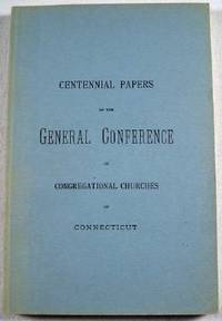
Published by Press of the Case, Lockwood & Brainard Company, Hartford, Connecticut 1976
- Softcover
- Signed
Seller: Resource Books, LLC, East Granby, CT, U.S.A.Resource Books, LLC
Contact seller5-star sellerCondition: Used - Very good
US$ 32.99
Free ShippingShips within U.S.A.Quantity: 1 available
Paperback. Condition: Very Good. Hartford, Connecticut: Press of the Case, Lockwood & Brainard Company, 1976. Reprint of the 1877 edition in celebration of the nations' bicentennial year, and in honor of the descendants of Mr. and Mrs. Harold Law Blakeslee, and signed by H. L. Blakeslee on the dedication page. A history of the f…irst hundred years of the Congregational Church in Connecticut. Light blue softcover, 214 pages. Light edgewear, minor uneven fading to the covers, contents very clean and free from names or other markings. Soft Cover. Very Good. 8vo - over 7¾" - 9¾" tall.
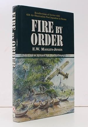
Published by Leo Cooper, [Barnsley, 1997
- Hardcover
- First Edition
- Signed
Seller: Island Books, Thakeham, West Sussex, United KingdomIsland Books
Contact seller4-star sellerCondition: Used
US$ 38.16
US$ 30.70 shippingShips from United Kingdom to U.S.A.Quantity: 1 available
8vo., First Edition, with 26 plates on 12, and 6 full-page maps and an illustration in the text; cloth, gilt back, a fine copy in unclipped dustwrapper. A PRESENTATION COPY FROM THE AUTHOR WITH HIS SIGNED HOLOGRAPH INSCRIPTION ON TITLE. Working as a key component of 14 Army, 656 Squadron's three flights of tiny Auster aircraft p…rovided air observation for the entire Allied force. Graham & Cole, U42.

Published by melissa press,france 1970
- Hardcover
- First Edition
- Signed
Seller: S.Carter, NEWPORT, , United KingdomS.Carter
Contact seller4-star sellerCondition: Used - Very good
US$ 47.70
US$ 26.59 shippingShips from United Kingdom to U.S.A.Quantity: 1 available
Hardcover. Condition: Very Good. 1st Edition. 1st.edition.1st.printing/vg hardback with green cloth spine.some foxing.numbered no.3 and signed by the author.text in english and french. Signed by Author(s).
Published by The Melissa Press, Draguignan, France 1970
- Hardcover
- First Edition
- Signed
Seller: Burwood Books, Wickham Market, , United KingdomBurwood Books
Contact seller5-star sellerCondition: Used - Very good
US$ 54.51
US$ 29.77 shippingShips from United Kingdom to U.S.A.Quantity: 1 available
Hardcover. Condition: Very Good. First Edition. Hardback. Slim 8vo.TEXT IN FRENCH and English, Original publisher's grey card boards with beige title label & red lettering to front board, spine bound with red tape, 7pp,very good indeed. Signed presentation from the author 'Pour Roderick Cave, un des rares textes que j'ai ecrits…et publies en francais. Cte Potocki de Montalk le Mai 1984 Wellington.' Very good indeed. Faint rubbing, very faint marking. Decent copy. Signedes.
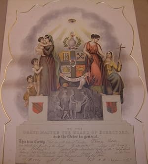
Published by Southampton: International Order of Odd Fellows. 1887
- Hardcover
- Signed
- Art Print
Seller: Wittenborn Art Books, San Francisco, CA, U.S.A.Wittenborn Art Books
Contact seller4-star sellerCondition: Used - Good
US$ 75.00
US$ 10.00 shippingShips within U.S.A.Quantity: 1 available
Condition: Good. 52x38 cm. Color print signed by lodge members. Very Good.Mounted on gilt mat board, will cost extra for shipping if shipped flat with the board; otherwise, the print alone can be rolled into a tube, and shipped for the normal cost.Item in plastic sleeve, new photos of item can be sent to customer upon request.
Published by melissa press,france 1970
- Hardcover
- First Edition
- Signed
Seller: S.Carter, NEWPORT, , United KingdomS.Carter
Contact seller4-star sellerCondition: Used - Very good
US$ 61.33
US$ 26.59 shippingShips from United Kingdom to U.S.A.Quantity: 1 available
Hardcover. Condition: Very Good. 1st Edition. 1st.edition.1st.printing/vg hardback with red cloth spine.numbered no.20 inscribed "for charles morris with friendly greetings" and then signed by the author.text in english and french. Inscribed by Author(s).
Published by melissa press,france 1970
- Hardcover
- First Edition
- Signed
Seller: S.Carter, NEWPORT, , United KingdomS.Carter
Contact seller4-star sellerCondition: Used - Very good
US$ 61.33
US$ 26.59 shippingShips from United Kingdom to U.S.A.Quantity: 1 available
Hardcover. Condition: Very Good. 1st Edition. 1st.edition.1st.printing/vg hardback with green cloth spine.numbered no.2 inscribed "for john morris and then signed by the author.text in english and french. Inscribed by Author(s).
Published by T.Fisher Unwin, London
- Hardcover
- Signed
Seller: PEND BOOKS, Newton Stewart, , United KingdomPEND BOOKS
Contact seller4-star sellerCondition: Used - Good
US$ 20.44
US$ 86.00 shippingShips from United Kingdom to U.S.A.Quantity: 1 available
Pictorial Cloth. Condition: Good. No Jacket. Reprint. Portraits, including frontispiece portrait of Gordon with tissue protection. 337pp. Freckling to page edges. Pictorial cloth with wear to corners and edges of spine. Spine has tear across near the middle and has been reglued at this point. Spine sunned. Inscription on free fe…p, which is darkened.
 More images
Published by Thomas Birch's Sons, Auctioneers, Philadelphia 1890
- Softcover
- Signed
Seller: The Kelmscott Bookshop, ABAA, Savage, MD, U.S.A.The Kelmscott Bookshop, ABAA
Contact seller5-star sellerCondition: Used - Very good
US$ 100.00
US$ 8.00 shippingShips within U.S.A.Quantity: 1 available
Paperback. Condition: Very Good -. Paperback. SCARCE. Catalogue of the estate sale of George Washington and nephews containing a list of 747 items. Included in the auction were numerous important letters, Washington's last private memorandum books, silver, glass, books, autographed letters from various eminent men, Franklin impr…ints, maps, plans, newspapers, Philadelphia imprints, works on the "black art," and more. The full contents of several of the letters are transcribed in the catalog including: a letter from Washington to Major General Henry Lee, a letter from Benjamin Franklin to his friend James Reed, and a couple of letters from Washington to his nephew Lawrence Lewis. Printed list of prices and names of purchasers are also included. The two most expensive items sold (each for $800) were a set of candlesticks and a letter by Benjamin Franklin. Lacks all 9 plates and addenda. Very good minus recased original paper wrappers. Interior yellowed; chipping and small tears to some pages but fairly clean. Tape repairs to rear wrapper. Quarto. 64 pages. Presidential History. PRES/3073.
Published by E J Brill 1916
- Hardcover
- First Edition
- Signed
Seller: Wildside Books, Eastbourne, , United KingdomWildside Books
Contact seller5-star sellerCondition: Used - Very good
US$ 102.21
US$ 15.88 shippingShips from United Kingdom to U.S.A.Quantity: 1 available
Hardcover. Condition: Very Good. 1st Edition. 4to, i-x, 265 pp, 10 plates, large folding map, 45 black and white figures in the text. Bound in contemporary half morocco, the leather on the spine rather rubbed and slight splitting to the front joint, top edge gilt, original wrappers bound in at the rear. A detailed report on the…sea pens collected on the Siboga Expedition to the Dutch East Indies between 1899 - 1900. A presentation copy from the author inscribed on the half title "With the compliments of the author Sydney J Hickson and many thanks for valuable assistance in the production of this work Sept 30 1920". Signed by Author(s).
Published by Government Printing Office, Washington DC 1865
- Softcover
- First Edition
- Signed
Seller: Ground Zero Books, Ltd., Silver Spring, MD, U.S.A.Ground Zero Books, Ltd.
Contact seller5-star sellerCondition: Used - Fair
US$ 175.00
US$ 5.00 shippingShips within U.S.A.Quantity: 1 available
Wraps. Condition: Fair. Presumed First Edition, First printing. vi, 20 pages. RARE surviving copy. Ex-library with some of the usual library stamps and markings. The United States National Cemetery System is a system of 164 cemeteries in the United States and its territories. The authority to create military burial places came d…uring the American Civil War, in an act passed by the U. S. Congress on July 17, 1862. The Department of the Army maintains 2 national cemeteries, Arlington National Cemetery and United States Soldiers' and Airmen's Home National Cemetery. This publication transmits the record of burials (alphabetically arranged, three--letter index,) at the National Cemetery, Alexandria, Va. This site was admirably adapted for burial purposes, and was laid off into blocks, and ranges, similar to the National Cemetery in Washington, D.C. Well-kept gravel walks traverse the grounds, the graves have bee sodded, and white tablets, letter in black, are placed at the head of each, giving name, rank, regiments, and date of death. A neat office has been erected for the accommodation and convenience of visitors. Every care and attention has been bestowed by the officer in charge in ornamenting and beautifying this cemetery, and making it a suitable resting place for our deceased soldiers. The total number of internment are: 3,372 white, 229 colored; total 3,601 of which 3,367 white soldiers, 2, United States Navy, 1 white civilian, 2 white females, and 229 colored soldiers. The roll of names of soldiers, was published for the information of their comrades and friends. Jas. M. Moore, Assistant Quartermaster reported as follows: On the evening of June 8th I left Washington D. C. for Belle Plain, where I jointed Colonel Bird, of the 1st regiment, 1st army corps, and proceeded to the battle-fields of the Wilderness and Spottsylvania Court House for the purpose of superintending the interments of the remains of Union soldiers, yet unburied, and marking their burial places for future identification. This work commenced on the 12th and was completed on the 24th of that month. The remains of all soldiers, both Union and rebel, interred, and headboards, with the name, rank, and regiments, places at each grave (with some exceptions in cases of rebels,) when it was possible to identify the deceased. The words "Unknown U.S. Soldiers, killed May 10 1864," on a neat tablet mark the remains of our own soldiers that could not be identified. On the battle ground of the Wilderness two cemeteries were laid out. The sites were well adapted for the resting-place of those who fell in the vicinity. On the battle-field of Spottsylvania but few men were found unburied, many of them having been interred by a Mr. Sandford in compliance with an agreement with General Sherman. Over seven hundred names were found on this battle-field, and tablets erected in memory of the deceased. Hundreds of graves on these battle-fields are without any marks whatever to distinguish them, and so covered with foliage that the visitor will be unable to find the last resting place of those who have fallen until the rains and snows of winter wash from the surface the light covering of earth and expose the remains. The accompanying list embraces the names of officers and mend whose graves headboards have been erected.
Published by London, Ford and Tilt 1864. 1864
- Hardcover
- Signed
Seller: Antiquariat Löcker, Wien, , AustriaAntiquariat Löcker
Contact seller5-star sellerCondition: Used
US$ 177.29
US$ 83.19 shippingShips from Austria to U.S.A.Quantity: 1 available
Die Tafeln zeigen die Bijoux der einzelnen Logenämter iV, 34 S., [15] Bl. mit zahlr. lithogr. Ill., OLn. mit goldener Deckelpräg., innen papierbeding etw. gebräunt, im Tafelteil ein durchgeh. Feuchtigkeitsfleck. "Von W.G. Clarke "as Grand Scribe E." im Vorwort hs. signiert.".
 More images
Published by A Black Pentacle Book, Manchester, England 1971
- Hardcover
- First Edition
- Signed
Seller: Olimpianbooks, Avon Lake, OH, U.S.A.Olimpianbooks
Contact seller5-star sellerCondition: Used - Good
US$ 649.99
Free ShippingShips within U.S.A.Quantity: 1 available
Hardcover. Condition: Good. No Jacket. 1st Edition. EXTREMELY RARE AND SCARCE, SIGNED copy 16/50, typed pages that are not numbered, full of symbols and text, it seems that one of the goals of the author's was that to "dispel the general concept that satanists are evil doers", pages clean and crisp, covers clean(rough covers as…of an old notebook), no highlighting or underlining. 100% Satisfaction guaranteed or your money back. Thank you for your interest. Free tracking number for each order. We ship the same day or the next business day. bm1. Signed by Author(s).
 More images
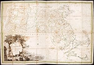
Published by B. & J. Loring, [Boston 1801
- Hardcover
- First Edition
- Signed
- Map
Seller: Donald A. Heald Rare Books (ABAA), New York, NY, U.S.A.Donald A. Heald Rare Books (ABAA)
Contact seller5-star sellerCopper-engraved map, with original outline colour, folded and mounted on linen. Publisher's paper label to verso, in good condition apart from some slight browning. Modern cloth chemise, within a morocco-backed cloth slipcase. A very rare and highly important early map of Massachusetts. The revised and much improved first "offic…ial" edition of the most important early map of Massachusetts. In three key ways, this edition is a great improvement over Osgood Carleton's 1798 original which was rejected for official sanction by the government of the Commonwealth. Firstly, the coastline and coastal islands have been more correctly rendered, largely due to the incorporation of information from the charts of Joseph Des Barres. Secondly, roads and streams that had been left incomplete in the earlier map were extended. Thirdly, some of the clutter of the 1798 map, engraved by Carleton's partner, John Norman, was removed, and the map is more attractive and informative, with a cleaner and crisper appearance. The history of the creation and publication of Carleton's map is interesting. There was a movement to create a state-sponsored map of Massachusetts as early as 1791. In 1795, after a failed attempt by the Massachusetts Historical Society, Osgood Carleton and John Norman signed a contract with the Commonwealth to create a state map based on surveys submitted by every town, with the entire map to be endorsed as to its quality by the state government. The map was produced in 1798, but it failed to win approval by the General Court which criticized Norman's engraving. The government asked Norman to redraw the map, although he had already printed 400 copies and went about marketing it without the official seal of approval from the Massachusetts government. Carleton, however, began to recompile the map and the firm of Callendar and Hill was contracted to engrave it. The present version of the map was approved by the General Court in 1801, and 500 copies were ordered to be printed. The map was published by B. & J. Loring in Boston, and offered (along with a companion map of Maine, which was then a constituent part of Massachusetts) at four dollars for a set, seven dollars if mounted on cloth with rollers, and eight dollars folded into cases. This copy of the map retains the publisher's original paper label, which forcefully asserts that this 1801 version of the Carleton map of Massachusetts, approved by the General Court, is "the only accurate one ever published of this state." The map is drawn on a scale of four miles to the inch, and gives a clear delineation of the boundaries and coastline of Massachusetts, and of the borders of each town in the state. The distance of each town from Boston and from their respective county seat is given, and major roads and streams are shown. Public and private institutions, including academies, meetinghouses, courthouses, etc., are located, as are topographical features such as mountains, ponds, rivers and streams. The cartouche, smaller in size and more attractive than that in the 1798 version, is still quite large, taking up much of the lower left corner of the map. It shows an Indian standing beside trees on a shoreline, with boats in the distant waters, and casks, anchors, nets, and a globe in the foreground. Danforth, 'The First Official Maps of Maine and Massachusetts,' in Imago Mundi 35 (1983), pp. 37-57; Krieger & Cobb, Mapping Boston, p. 52; Phillips, A List of Maps of America, p. 400; Ristow, American Maps and Mapmakers, pp. 89-92.

- Softcover
- Signed
- Manuscript
Seller: Main Street Fine Books & Mss, ABAA, Galena, IL, U.S.A.Main Street Fine Books & Mss, ABAA
Contact seller5-star sellerBolivar, TN: Head-Quarters, Com'dr of the Post, 1862 November 3. Handbill. Small 8vo (5" X 7 3/4"). Very good. Clean and nice, though bottom and left margins heavily chipped, not affecting text. Mason Brayman announces his taking command of the Post of Bolivar, per Major General J.B. McPherson's order, and lists the several regi…ments that will report to this headquarters. Signed in type at the conclusion by M. Brayman as "Brig Gen'l Commanding Post." Brayman (1813-95) was a New York attorney who migrated to Michigan, then Illinois -- where in 1848 when Abraham Lincoln was elected to Congress and moved to Washington he rented the Lincoln's home. He served with the 29th Illinois Volunteer Infantry and rose to major general during a short but heroic career, after the war editing the "Illinois State Journal" and n 1876 appointed Governor of the Idaho Territory. Given the crude typesetting, quite possibly printed on a field press. Very scarce.
 More images
Order from Michael Wallace to Thomas Crawley, Surveyor-General of Lands in the Island of Cape-Breton
Published by May 11, 1824, Halifax 1824
- Signed
Seller: Attic Books (ABAC, ILAB), London, ON, CanadaAttic Books (ABAC, ILAB)
Contact seller5-star sellerCondition: Used - Good
US$ 200.00
US$ 15.00 shippingShips from Canada to U.S.A.Quantity: 1 available
Condition: Good. One 32 cm document written and signed by Wallace. Three horizontal creases. Reverse side has two tape repairs. Michael Wallace (1744-1831) was a merchant, politician, judge, and colonial administrator. A central figure in early 19th-centiry Nova Scotia, he first rose to prominence in 1785 when elected to the Hou…se of Assembly as a representative for Halifax County. After that, he succeeded in ingratiating himself with Loyalists prominent in the local administration and rose to become provincial treasurer in 1797. By 1820 he succeeded John Wentworth as surveyor general of the colony. In this document, as President and Commander in Chief of the Province, he orders Thomas Crawley to survey 100 acres of land near Lingan for John Dunfy. Eventually Wallace became administrator during the absences of the lieutenant governor. His uncompromising Toryism and antagonistic personality made him increasing unpopular in later years, while his adherence to the 18th-century style of dress gave the impression he was an anachronism. While he died a wealthy man, critics believed much of his money was obtained through speculation with public funds. Nevertheless, when he died, his funeral was a public ceremony attended by officials and a long train of inhabitants.
 More images
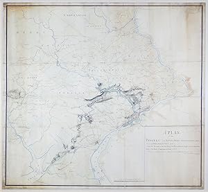
Published by [Philadelphia] 1778
- First Edition
- Signed
- Map
Seller: Arader Books, New York, NY, U.S.A.Arader Books
Contact seller5-star sellerCondition: Used - Very good
US$ 2,500,000.00
Free ShippingShips within U.S.A.Quantity: 1 available
No binding. Condition: Very good. First. ONE OF THREE SURVIVING HEADQUARTERS MAPS FOR THE PHILADELPHIA CAMPAIGN, AND THE ONLY ONE MADE DURING THE CAMPAIGN. Manuscript map at a scale of 2 miles to 1 inch. [Philadelphia, ca. 1778]. Twelve sheets joined (outer borders: 51 3/8" x 53 1/8", 1305mm x 1350mm). Black and sanguine ink, ha…nd-colored. Mounted on linen. Framed to full museum specifications. Some peripheral soiling. Repairs to the joins and some edge-tears, including a small marginal loss. Early in the Revolutionary War, the Commander-in-Chief of the British land forces, General William Howe, believed that the capture of the young nation's capital, Philadelphia, would demoralize the rebels to the point of laying down their arms. It was with high hopes for victory in the war, then, that British forces under Howe landed at Elk Ferry (now Elkton, Maryland), south of Philadelphia, on August 25, 1777, with the goal of taking the capital and crushing the Continental Army commanded by George Washington. This manuscript map by Charles Blaskowitz (c.1743-1823), the preeminent surveyor of the British campaign, shows the movements of the British forces as they marched and fought their way from Elk Ferry towards Philadelphia, indicating with red lines the routes of the British troops under Howe, the British and Hessian troops under Charles Cornwallis, and the Hessian auxiliaries under Wilhelm von Knyphausen. Our map illustrates how vital cartography was to the waging of war. Blaskowitz, for example, marks the location of the cheveaux de frise that the American forces had set up in the Delaware River to prevent British ships from approaching Philadelphia; Washington used the same tactics in the Hudson, adding two huge chain booms. Other maps show some of these same things -- William Faden made a manuscript map in 1777 "exhibiting the several works erected by the rebels" in the river -- but our map is of signal historical importance for being one of just three surviving large-format "Headquarters Maps" from the Philadelphia Campaign, and the only one made during the campaign. Blaskowitz's map shows more detail, particularly of the road network, taverns, and meeting houses, than the two maps that he probably used as sources: Nicholas Scull and George Heap's map of Philadelphia and its surroundings, first published in 1752, and Scull's map of southeastern Pennsylvania of 1759. Blaskowitz's map includes a much larger area than that of the campaign proper. Compare, for instance, the map of the same campaign made by John André (Progress of the British Army from the landing in Elk River to the taking possession of Philadelphia, anno 1777: Huntington Library HM 3086r): it includes no more territory than necessary to show the route of the army to Philadelphia. Blaskowitz made his map for General Sir William Erskine (1728-1795), who participated in the Philadelphia Campaign, and for whom Blaskowitz has previously made a map of the New York Campaign in 1776 (Richard H. Brown Revolutionary War Map Collection at Mount Vernon). Usually in the eighteenth century the taking of an enemy's capital entailed the end of the war, but this was not the case after the British took Philadelphia. The Continental Congress had left the city for Lancaster before the British arrived, and in any case, the British capture of Philadelphia did not bring any important strategic advantages. In fact, Washington used the winter of 1777-78 to train the Continental Army into a much more expert fighting force. The high hopes that the British had for the Philadelphia Campaign when Blaskowitz began depicting it on his map were not achieved, and the war continued for another six years. Purchased at Christie's New York (7 December 2012, "Property of Mrs. M. Sharpe Erskine's Trust," lot 64). Catalogued by Mr. Chet van Duzer, revised by JL Rosenberg (D.Phil, Oxon.).

Published by Bunos Aires 1943
- Signed
Seller: Chaco 4ever Books, Montevideo, MO, UruguayChaco 4ever Books
Contact seller5-star sellerCondition: Used - Near fine
US$ 700.00
US$ 31.50 shippingShips from Uruguay to U.S.A.Quantity: 1 available
wrappers. Condition: Very Good. 315 x 220 mm, In Buenos Aires, On december, 1943. Signed in black ink Juan Perón. MINISTERIO DEL INTERIOR DEPARTAMENTO NACIONAL DEL TRABAJO OBJETO: Crear la DIRECCION GENERAL DE PRENSA Y DIFUSION. Buenos Aires, diciembre de 1943. C41. Firmado por el autor.
- Signed
Seller: Main Street Fine Books & Mss, ABAA, Galena, IL, U.S.A.Main Street Fine Books & Mss, ABAA
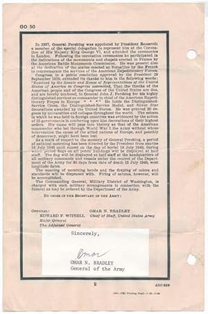
Contact seller5-star seller"The G.I.s General," beloved American Army general active during World War II and the last five-star general; from 1949-53 served as first permanent chairman of the Joint Chiefs of Staff. Later life signature ("Omar" in black ballpoint) tipped to the close of a printed "General Orders No. 50," 6" X 9", 2pp (recto and verso), iss…ued by the Department of the Army in Washington, DC on 15 July 1948. Very good. Mild edgewear; two-punched at left (not affecting text). As Chief of Staff of the U.S. Army, Bradley makes the solemn announcement that "The death of General John Joseph Pershing, General of the Armies of the United States, which occurred at Washington, D.C., on 15 July 1948, is announced to the Army with deep regret." He goes on to summarize Pershing's long career and note a period of mourning and the wearing of mourning bands. Below Bradley's typeset name a white 3" X 1½" slip is affixed, clipped from a typed letter, with "Sincerely," typed at top and "OMAR N. BRADLEY / General of the Army" typed at bottom, between which Bradley signs his first name. Accompanied by a fine glossy 8" X 10" black and white news agency photograph, a candid half-length portrait of a smiling Bradley in uniform. Caption printed vertically along right edge dates this 27 June 1947 and describes the scene: "Gen. Omar N. Bradley, Veterans Administrator, shown leaving the White House after conferring with President Truman today, has been named by Washington observers as the most likely choice for U.S. Army Chief of Staff to succeed General of the Army Dwight D. Eisenhower." An interesting, unusual pair.
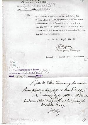
- Signed
Seller: Sophie Dupre ABA ILAB PADA, Calne, , United KingdomSophie Dupre ABA ILAB PADA
Contact seller2-star sellerCondition: Used
US$ 804.07
US$ 5.42 shippingShips from United Kingdom to U.S.A.Quantity: 1 available
with transcription and translation, addressed to "Halting-Place Inspectorate 6", saying he is "suspending the sentence of a Field Court-Marshal. at Tourcoing of the 18th October on Moise Dubly", as there is an "appeal to a new Court to hear the case", the second part, signed 'Denny', returns the document "for further action" wit…h the enclosure [not present] as requested, the first part typed, both with ink stamps of origin and insertions, 1 side folio, 6th Army Head Quarters, Turcoing, Northern France and no place, 21st - 23rd November slight closed tear in top margin After the proclamation of the German Empire in 1871, only Bavaria retained an arm' separate from Prussia. Rupprecht is considered one of the best of the 'royal' generals of the time. By the middle of the war he was becoming more and more critical of its conduct, but continued to serve till the Armistice. At this period he had ideas of lowering Prussia's dominance by creating a third territory from parts of Belgium, the Netherlands, Northern France and Luxembourg within the Empire. His first wife, who died in 1912, was a sister of the Queen of the Belgians, and his second, 1921, was Princess Antoinette of Luxembourg. Rupprecht was a direct descendant of Charles I and Rupprecht's mother, Queen Maria Theresia, was a d'Este of the family of James II's Queen. When she died in 1919 he became the Jacobite heir, styled by some "Duke of Cornwall & Rothesay". In Bavaria, monarchists continued to look to him for a restoration, both after WWI and WWII, and at his death he was given a royal funeral in Munich. We think, from newspapers of 1910-1912, that Moise Dubly is the local Frenchman living at 52 rue de Gand, with a keen interest in football. Was he arraigned in 1915 for some act of sabotage or resistance? (Transcription) A.O.K. 6. Armee empfangen 7.11.15 Buch Nr. 29558 Abteil III [.] Anlagen III. Zur Etappen-Inspektion 6. Ich hebe das Urteil eines Feldkriegsgerichts der mob.Etappenkommandantur 4./XIII. Turcoing vom 18. Oktober gegen Moise Dubly auf. Die Berufung eines neuen erkennenden Gerichtes ist zu veranlassen. A.H.Qu. 21.11.15. [Signed] Rupprecht Kronprinz v. Bayern General-Oberst der Infanterie. III. Etappeninspektion 6. Armee empfangen am 22.11.15 Nr. 37487 Abteil III.1931. Anlagen. 1 Akt. Zur Etappen Kommandantur Turcoing für weitere Veranlassung bezüglich des Moise Dubly. Die mitvergelegten Akten El. Cramer sind vom AOK 6 gefordert zurückgelangt. EHQ 23.11.15 [Signed] Denny (Translation) 6th Army Headquarters. Received 7th November 1915. Number in Book 29558. Section III. [.] enclosures. III. To Halting-Place Inspectorate 6. I am suspending the sentence of a Field Court-Marshal of mobile Halting-Place Command 4./XIII at Tourcoing of the 18th October on Moise Dubly, The reason is the appeal to a new Court to hear the case. Headquarters, 21st November 1915. [Signed]. Rupprecht Crown Prince of Bavaria Colonel-General of Infantry. Halting-Place Inspectorate 6th Army. Received 22nd November 1915. No. 37487. Secrion III.1931. Enclosures 1 Document To Halting-Place Command, Turcoing for further action concerning Moise Dubly The accompanying Documents [.] forwarded from 6th Army Headquarters are returned. Halting-Place Headquarters 23rd November 1915. [Signed] Denny.


