Order Total (1 Item Items):
Shipping Destination:

Hand Coloured Map Kent (29 results)
Skip to main search results
Search filters
Product Type
- All Product Types
- Books (22)
- Magazines & Periodicals (No further results match this refinement)
- Comics (No further results match this refinement)
- Sheet Music (No further results match this refinement)
- Art, Prints & Posters (No further results match this refinement)
- Photographs (No further results match this refinement)
- Maps (7)
- Manuscripts & Paper Collectibles (No further results match this refinement)
Condition Learn more
- New (No further results match this refinement)
- As New, Fine or Near Fine (4)
- Very Good or Good (12)
- Fair or Poor (No further results match this refinement)
- As Described (13)
Binding
- All Bindings
- Hardcover (2)
- Softcover (No further results match this refinement)
Collectible Attributes
- First Edition (1)
- Signed (No further results match this refinement)
- Dust Jacket (1)
- Seller-Supplied Images (24)
- Not Print on Demand (29)
Language (2)
Price
- Any Price
- Under US$ 25 (No further results match this refinement)
- US$ 25 to US$ 50
- Over US$ 50
Free Shipping
- Free Shipping to U.S.A. (No further results match this refinement)
Seller Location
Seller Rating
-

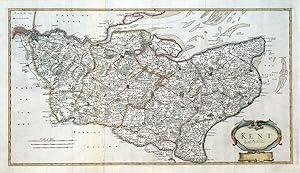
KENT - an Original Antique Hand-Coloured Map, 1842
Language: English
Published by LEWIS, London, 1842
Seller: K Books Ltd ABA ILAB, York, YORKS, United Kingdom
Association Member: ABA ILAB PBFA
Seller rating 5 out of 5 stars

US$ 27.79
US$ 26.31 shipping
Ships from United Kingdom to U.S.A.Quantity: 1 available
Add to basketNo Binding. Condition: Very Good. R CREIGHTON (illustrator). Reprint. An original antique engraved map, which shows the Unions outlined in colour. Mounted (matted) and ready to frame. Shows towns, villages, churches, parks, hills, roads, rivers, railways etc. Drawn by R Creighton, originally in 1831, engraved by J & C Walker. Compass indicator top right, numbered key to the Poor Law Unions bottom left, with scale in miles below.
-
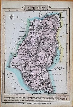
Antique Hand Coloured Map of Kent - an Original Antique Hand-Coloured British Map
Language: English
Published by Alexander Hogg, London, 1784
Seller: K Books Ltd ABA ILAB, York, YORKS, United Kingdom
Association Member: ABA ILAB PBFA
Seller rating 5 out of 5 stars
US$ 55.58
US$ 26.31 shipping
Ships from United Kingdom to U.S.A.Quantity: 1 available
Add to basketNo Binding. Condition: Very Good. Attractive Antique hand-coloured map showing boroughs, market towns, villages, castles, parks, roads etc.by Alexander Hogg. Plate size approx. 6.5 x 8 inches 16 x 24 cms. Mounted and ready to frame, mount size approx. 12 x 10 inches, 30 x 25 cms, VERY GOOD, ca 1784 - 95. *Decorative and unusual - highly recommended.
-
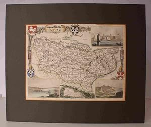
Kent, Antiquarian Map - an Original Antique Hand Coloured Map Printed Ca. 1829
Language: English
Published by George Virtue, London, 1829
Seller: K Books Ltd ABA ILAB, York, YORKS, United Kingdom
Association Member: ABA ILAB PBFA
Seller rating 5 out of 5 stars
US$ 62.53
US$ 26.31 shipping
Ships from United Kingdom to U.S.A.Quantity: 1 available
Add to basketNo Binding. Condition: Very Good. An original antique hand coloured map of Kent. Mounted and ready to frame . Very good condition . A splendid vintage map - decorative, attractive and somewhat uncommon. Delicate colouring - not contemporary. An impressive map with a great amount of detail and in splendid condition, dated 1829 and printed by G.Virtue.
-

A Hand List of the Birds of the Sevenoaks or Western District of Kent Illustrated with 41 coloured plates from original Water Colours by the Author, a number of plates in half-tone and line, and a Map of the District.
Published by London H. F. & G. Witherby Ltd 1942, 1942
Seller: Chaucer Bookshop ABA ILAB, Canterbury, United Kingdom
Seller rating 5 out of 5 stars
First Edition
US$ 72.26
US$ 33.73 shipping
Ships from United Kingdom to U.S.A.Quantity: 1 available
Add to basketFIRST EDITION 4to. blue clothbound hardback, gilt, with dust jacket. 165pp. with colour and b/w illustrations. A clean copy with no previous owners' markings or inscriptions. Dust jacket has been price-clipped. Foxing to first and last few pages and foredge and light foxing throughout. Light fading to cloth spine and light wear to top and base of cloth spine. Ageing to dust jacket with wear to all edges, including small chips missing to spine and light soiling. A VERY GOOD COPY in a Good Dust Jacket. (Shelf 11/14) NOTE: Heavy Book (1.5 kg+): postage outside the UK might incur a surcharge. Buyer is responsible for any additional duties, taxes, or fees required by recipient's country.** Pictures available upon request.** Visit our homepage for our shop opening hours. Over 20,000 books in stock - come and browse. PayPal, credit and most debit cards welcome. Books posted worldwide. For any queries please contact us direct.
-
Engraved Map of Kent. ENGRAVED MAP FINELY COLOURED BY HAND
Published by [Thomas Moule, c.1840], 1840
Seller: Island Books, Thakeham, West Sussex, United Kingdom
Seller rating 5 out of 5 stars
Map
US$ 66.70
US$ 31.30 shipping
Ships from United Kingdom to U.S.A.Quantity: 1 available
Add to basketSteel-engraved map on paper; measuring 8.0 x 10.5 ins (approx. 20.00 x 26.5 cms), FINELY COLOURED BY HAND; attractively mounted in bevelled-edge steel-grey card with bevelled edges, a very good, bright, clean copy. The map is enclosed by an elaborate pictorial border incorporating four coats-of-arms and various other symbolic figures, and includes three charming vignettes of Greenwich Hospital, Rochester and Dover.
-
A TOPOGRAPHICAL MAP OF THE COUNTY OF KENT, IN TWENTY FIVE SHEETS. ON A SCALE OF TWO INCHES TO A MILE, from an Actual Survey; in which are expressed all the Roads, Lanes, Churches, Towns, Villages, Noblemen and Gentlemens Seats, Roman Roads, Hills, Rivers, Woods, Cottages & every thing Remarkable in the County; together with the Division of the Lathes & their Subdivision into Hundreds. (Deluxe hand-coloured edition with the extra uncoloured Plan of Canterbury)
Published by London Printed for Rob. Sayer and Jn. Bennett, Map and Printsellers, No. 53 Fleet Street Published according to Act of Parliament, January ye 1st 1779, 1779
Seller: Chaucer Bookshop ABA ILAB, Canterbury, United Kingdom
Seller rating 5 out of 5 stars
US$ 10,387.05
US$ 33.73 shipping
Ships from United Kingdom to U.S.A.Quantity: 1 available
Add to basket1779 Edition with the extra uncoloured Plan of Canterbury. Folio (approx. 54.5 x 41cm) hardback rebound in half black morocco with raised bands, gilt, to spine and marbled boards with matching black morocco title label, gilt, to upper board. New endpapers. Each map approx. 53.5 x 73.5cm. Contains Title page (Plate 25) with hand-coloured border, Dedication (Plate 21) with hand-coloured border, Map of the County of Kent with outline hand-colouring (no Plate number), 23 fully hand-coloured plates with each Hundred in different colour wash, and an additional uncoloured Plan of Canterbury (no Plate number). Previous bookseller's pencil notes to ffep, else a clean copy with no previous owners' markings or inscriptions. One map with slight crease to centre fold. A couple of other maps with slightly ragged edges, not affecting the image. Tiny chip to marbled paper of upper board and a few tiny white specks to lower morocco corner (please see photos), otherwise a REMARKABLY CLEAN, BRIGHT COPY in VERY GOOD CONDITION. (Shelf 3) PLEASE NOTE: VERY Heavy BOOK (3.5 kg+) Postage rates vary according to destination, weight and speed. For an accurate overseas quote PLEASE either call or email us before ordering. [AbeBooks shipping quote is based on items weighing up to 1 kilo only]. Buyer is responsible for any additional duties, taxes, or fees required by recipient's country.** Pictures available upon request.** Visit our homepage for our shop opening hours. Over 20,000 books in stock - come and browse. PayPal, credit and most debit cards welcome. Books posted worldwide. For any queries please contact us direct.
-
KENT, ANTIQUE HAND COLOURED MAP SHOWING THE HUNDREDS OF TOLTINGTROUGH AND SHAMEL
Language: English
Publication Date: 1820
Seller: K Books Ltd ABA ILAB, York, YORKS, United Kingdom
Association Member: ABA ILAB PBFA
Seller rating 5 out of 5 stars
US$ 104.22
US$ 26.31 shipping
Ships from United Kingdom to U.S.A.Quantity: 1 available
Add to basketNo Binding. Condition: Very Good. A LARGE ANTIQUE MAP SHOWING THE HUNDREDS OF TOLTINGTROUGH AND SHAMEL IN NORTH KENT, HAND COLOURED , COLOURING NOT CONTEMPORARY BUT DELICATELY AND EXPERTLY EXECUTED, SHOWS THE VILLAGES OF GRAVESEND, NORTH FLEET, CHALK COBHAM, COBHAM HALL, MEOPHAM, LUDDESTON, COOKSTONE, STROUD, COWLING, CLIFF ETC - TOO LARGE TO MOUNT SENT ROLLED IN A STRONG TUBE.
-
Antique Map KENT, Wallis Original Hand Coloured Miniature County Map c1810
Seller: Lindisfarne Prints, Shrewsbury, SHROP, United Kingdom
Seller rating 5 out of 5 stars
Map
US$ 38.91
US$ 14.84 shipping
Ships from United Kingdom to U.S.A.Quantity: 1 available
Add to basketAntique Map�KENTby James WallisPublished London 1810 in "Wallis's New Pocket Edition of the English Counties or Travelling Companion".An original early 19th century copper engraved antique county map of Kent, England.An attractive miniature map enhanced with original hand colouring.Also features a scale of miles and an explanation of symbols.Fine, clean condition .Approx. 5.5" x 4" (140mm x 100mm) overall.A GENUINE ORIGINAL ANTIQUE MAP GUARANTEED OVER 200 YEARS OLD FROM LINDISFARNE PRINTST V 3 23We do not deal in reproductions, facsimiles or modern copies of any kind.
-

Antique Map KENT, Capper Original Hand Coloured County Map 1808
Seller: Lindisfarne Prints, Shrewsbury, SHROP, United Kingdom
Seller rating 5 out of 5 stars
Map
US$ 38.91
US$ 14.84 shipping
Ships from United Kingdom to U.S.A.Quantity: 1 available
Add to basketAntique Map�KENTby Benjamin CapperPublished by Richard Phillips, London 1808 in "A Topographical Dictionary of the United Kingdom".An original early 19th century copper engraved antique map of Kent, England. Enhanced with original hand colouring. Dated in the plate.Fine condition other than insignificant age related blemishes, free of repairs or restoration, blank verso.Approx. 7" x 4" (180mm x 100mm) map area only, with margins beyond.A GENUINE ANTIQUE MAP GUARANTEED OVER 210 YEARS OLD FROM LINDISFARNE PRINTST71921.
-
Antique Map KENT, Darton, Original Hand Coloured Miniature County Map c1822
Seller: Lindisfarne Prints, Shrewsbury, SHROP, United Kingdom
Seller rating 5 out of 5 stars
Map
US$ 44.47
US$ 14.84 shipping
Ships from United Kingdom to U.S.A.Quantity: 1 available
Add to basketAntique Map�KENTPublished London circa 1822byWilliam Dartonfor" Darton's new Miniature Atlas."A scarce, original, detailed, early 19th century copper engraved antique county map of Kent, England.An attractive miniature map enhanced with early hand colouring.The map clearly features cities, towns, villages, hamlets, roads, canals and rivers.Fine condition save for a very faint library ink stamp to the right hand margin, this could easily be masked off when mounting and framing. Blank verso� and without foldsApprox. 6" x 3.5" (150mm x 90mm) overall.A GENUINE ORIGINAL ANTIQUE MAP GUARANTEED OVER 200 YEARS OLD FROM LINDISFARNE PRINTST R 4 23We do not deal in reproductions, facsimiles or modern copies of any kind.�.
-
![Seller image for A Hand-Coloured Map of Kent [1] for sale by Little Stour Books PBFA Member](https://pictures.abebooks.com/inventory/md/md1055345897.jpg)
A Hand-Coloured Map of Kent [1]
Published by Published by J. & J. Cunder, Albion, London . London 1815., 1815
Seller: Little Stour Books PBFA Member, Canterbury, United Kingdom
Association Member: PBFA
Seller rating 5 out of 5 stars
US$ 104.22
US$ 33.73 shipping
Ships from United Kingdom to U.S.A.Quantity: 1 available
Add to basketHand-coloured map of Kent measuring 10'' x 8''. In Very Good clean and bright condition. Member of the P.B.F.A. KENT [Maps].
-

A Hand-Coloured Map of Kent
Published by circa . London circa 1845., 1845
Seller: Little Stour Books PBFA Member, Canterbury, United Kingdom
Association Member: PBFA
Seller rating 5 out of 5 stars
US$ 104.22
US$ 33.73 shipping
Ships from United Kingdom to U.S.A.Quantity: 1 available
Add to basketDelineated hand-coloured map of Kent measuring 10'' x 8''. In Very Good clean and bright condition. Member of the P.B.F.A. KENT [Maps].
-
![Seller image for A Hand-Coloured Map of Kent [2] for sale by Little Stour Books PBFA Member](https://pictures.abebooks.com/inventory/md/md1055345893.jpg)
A Hand-Coloured Map of Kent [2]
Published by J. Archer, Pentonville, London . London 1848., 1848
Seller: Little Stour Books PBFA Member, Canterbury, United Kingdom
Association Member: PBFA
Seller rating 5 out of 5 stars
US$ 104.22
US$ 33.73 shipping
Ships from United Kingdom to U.S.A.Quantity: 1 available
Add to basketHand-coloured map of Kent measuring 10'' x 8''. In Very Good clean and bright condition. Member of the P.B.F.A. KENT [Maps].
-
![Seller image for A Hand-Coloured Map of Kent [1] for sale by Little Stour Books PBFA Member](https://pictures.abebooks.com/inventory/md/md1055345892.jpg)
A Hand-Coloured Map of Kent [1]
Published by J. Archer, Pentonville, London . London 1848., 1848
Seller: Little Stour Books PBFA Member, Canterbury, United Kingdom
Association Member: PBFA
Seller rating 5 out of 5 stars
US$ 104.22
US$ 33.73 shipping
Ships from United Kingdom to U.S.A.Quantity: 1 available
Add to basketHand-coloured map of Kent measuring 10'' x 8''. In Very Good clean and bright condition. Member of the P.B.F.A. KENT [Maps].
-

A Hand-Coloured Map of Kent circa 1840
Published by Lewis' Topographical Dictionary, London circa . London circa 1840., 1840
Seller: Little Stour Books PBFA Member, Canterbury, United Kingdom
Association Member: PBFA
Seller rating 5 out of 5 stars
US$ 118.11
US$ 33.73 shipping
Ships from United Kingdom to U.S.A.Quantity: 1 available
Add to basketMounted hand-coloured map of Kent measuring 10'' x 8''. Drawn and engraved for Lewis' Topographical Dictionary and in Fine bright fresh condition. Member of the P.B.F.A. KENT [Maps].
-
FARM LAND MAPPED FOR LAND SURROUNDING GUSTON KENT Large scale map with hand coloured outline of farm land, manuscript inscriptions of crop and soil details. Guston, Whitfield, East Langdon, Duke of Yorks Military school.
Published by CIRCA 1940, KENT, 1940
Seller: Marrins Bookshop, Folkestone, KENT, United Kingdom
Association Member: ABA ILAB PBFA
Seller rating 4 out of 5 stars

US$ 173.70
US$ 34.20 shipping
Ships from United Kingdom to U.S.A.Quantity: 1 available
Add to basket50 x 51 inches.
-
Antique Map DOVER KENT Town Street Plan Dawson Original Hand Coloured 1832
Seller: Lindisfarne Prints, Shrewsbury, SHROP, United Kingdom
Seller rating 5 out of 5 stars
Map
US$ 52.80
US$ 14.84 shipping
Ships from United Kingdom to U.S.A.Quantity: 1 available
Add to basketAntique MapDOVOR�by Robert Kearsley DawsonPublished 1832An original 19th century antique street plan of the town of Dover, Kent England.�Drawn up by Lieutenant R.K. Dawson of the Royal Engineers and published by the Boundaries Commission in 1832.The whole country was surveyed for the commission to support the 1832 reform bill - a major shake-up of the nation's parliamentary representation.The map is on a scale of �4 inches to the mile �affording great detail including individual buildings.�It's interesting to compare the 19th century map with the much expanded Dover of the present day.Enhanced with original hand colouring and a colour key to the various boundaries and wards. Accompanying the map are 2 original pages of the report on the proposed changes to the boundaries, population etc.Fine condition, free of repairs or restoration, blank verso.Approx. 13" x 8" (330mm x 200mm) overall (as depicted).A GENUINE ORIGINAL ANTIQUE MAP GUARANTEED OVER 180 YEARS OLD FROM LINDISFARNE PRINTSNM C 8 24.
-

A Hand-Coloured Map of Kent; South East From London 1741
Published by Published by T. Badeslade and W. H. Toms September 29th . 1741., 1741
Seller: Little Stour Books PBFA Member, Canterbury, United Kingdom
Association Member: PBFA
Seller rating 5 out of 5 stars
US$ 312.65
US$ 33.73 shipping
Ships from United Kingdom to U.S.A.Quantity: 1 available
Add to basketMounted hand-coloured map measuring 6'' x 6''. Text to the side gives details of 2 cites, 2 boroughs, sends 10 members; including 4 of the Cinque Ports, which sends 8 Barons to Parliament, make in all 18. It has likewise 24 Market Towns, and 408 Parishes. It lists the Cities, Market Towns with days of the Market. Surrey spelt 'Surry.' Extremely scarce and in near Fine condition. Member of the P.B.F.A. KENT [Maps].
-

A Hand-Coloured Map of Kent 1744; An Improved Map of Kent Containing the Borough and Market Towns, with those Adjoining; also, its Principal Roads and Rivers by I. Cowley, Geographer to His Majesty
Published by I. Cowley . London 1744., 1744
Seller: Little Stour Books PBFA Member, Canterbury, United Kingdom
Association Member: PBFA
Seller rating 5 out of 5 stars
US$ 409.92
US$ 33.73 shipping
Ships from United Kingdom to U.S.A.Quantity: 1 available
Add to basketMounted hand-coloured map of Kent measuring 8'' x 6'' in 12 inch by 10 inch mount. In very near Fine condition. Member of the P.B.F.A. KENT [Maps].
-
A Topographical Hand Coloured Map of the County of Kent in 25 Sheets: Sheet Covering Ickham to the West, Pegwell, Greystone Bay, Deal and Walmer to the East, Stourmouth and Ebsfleet to the North, Kingsdown and Eythorne to the South
Published by Printed by Drury and Andrews, London . London 1769., 1769
Seller: Little Stour Books PBFA Member, Canterbury, United Kingdom
Association Member: PBFA
Seller rating 5 out of 5 stars
US$ 673.94
US$ 33.73 shipping
Ships from United Kingdom to U.S.A.Quantity: 1 available
Add to basketOriginal hand coloured map mounted on linen measuring 27�'' x 18''. Super boats out at sea also showing 'Brake' and 'Crofs Ledge' [Goodwin Sands]. Just a little fraying to the edges, colours sharp and bright, without any creases and in Very Good clean condition. Member of the P.B.F.A. KENT [Stourmouth].
-

A Hand-Coloured Map of Rochester, Kent From the Ordnance Survey with Municipal Corporation Boundaries
Published by Ordnance Survey . 1835., 1835
Seller: Little Stour Books PBFA Member, Canterbury, United Kingdom
Association Member: PBFA
Seller rating 5 out of 5 stars
US$ 173.70
US$ 33.73 shipping
Ships from United Kingdom to U.S.A.Quantity: 1 available
Add to basketHand-coloured map of Rochester measuring 13�'' x 10'' 4 inches to a mile, with small inset map 1 inch to a mile. Also enclosed is a 4 page document titled 'Rochester, Report upon the Proposed Municipal Boundary and Division into Wards of the Borough of Rochester.' In Very Good condition. Member of the P.B.F.A. KENT [Maps].
-

A Hand-Coloured Map of Maidstone, Kent From the Ordnance Survey with Municipal Corporation Boundaries
Published by Ordnance Survey . 1835., 1835
Seller: Little Stour Books PBFA Member, Canterbury, United Kingdom
Association Member: PBFA
Seller rating 5 out of 5 stars
US$ 173.70
US$ 33.73 shipping
Ships from United Kingdom to U.S.A.Quantity: 1 available
Add to basketHand-coloured map of Maidstone measuring 13�'' x 8�'' 4 inches to a mile, with small inset map 1 inch to a mile. Also enclosed is a 4 page document titled 'Maidstone, Report upon the Proposed Municipal Boundary and Division into Wards of the Borough of Maidstone.' Two brown stains to the front page of the document. Member of the P.B.F.A. KENT [Maps].
-

A Hand-Coloured Map of Kent 1770
Published by Seller . London 1770., 1770
Seller: Little Stour Books PBFA Member, Canterbury, United Kingdom
Association Member: PBFA
Seller rating 5 out of 5 stars
US$ 270.97
US$ 33.73 shipping
Ships from United Kingdom to U.S.A.Quantity: 1 available
Add to basketMounted hand-coloured map of Kent measuring 5'' x 6'' in 11 inch by 10 inch mount. In Very Good clean condition. Part text below and to the reverse of the map. Member of the P.B.F.A. KENT [Maps].
-

A Hand-Coloured Map of Kent 1829
Published by Published by G. Virtue, 26 Ivy Lane, London . London 1829., 1829
Seller: Little Stour Books PBFA Member, Canterbury, United Kingdom
Association Member: PBFA
Seller rating 5 out of 5 stars
US$ 312.65
US$ 33.73 shipping
Ships from United Kingdom to U.S.A.Quantity: 1 available
Add to basketHand-coloured map of Kent measuring 17'' x 14''. Scale 3'' to 12 miles. One small professionally repaired tear to the bottom left corner and in Very Good clean and fresh condition. Member of the P.B.F.A. KENT [Maps].
-

1722 Original Antique LARGE Map - KENT by Robert Morden HAND COLOURED (LM5-1)
Seller: Antique Paper Company, ASHFORD, KENT, United Kingdom
Seller rating 2 out of 5 stars

Map
US$ 194.54
US$ 8.09 shipping
Ships from United Kingdom to U.S.A.Quantity: 1 available
Add to basketNo Binding. Condition: Fine. No Jacket. Listing Template 2018 Home About Us View Feedback Contact Us 1722 Original Antique LARGE Map - KENT by Robert Morden HAND COLOURED (LM5-1)Click image to enlargeDescription1722Original Antique Map titled KENT by Robt MordenA fine and rare Copper Engraved original antique Map of Kent by Robert Mordenwith decorative Cartouche and hand coloured.Robert Morden(c. 1650 and#8211; 1703) was an English bookseller, publisher, and maker of maps and globes. He was among the first successful commercial map makers.Between about 1675 and his death in 1703, he was based under the sign of the Atlas at premises in Cornhill and New Cheapside,London. Hiscartographicaloutput was large and varied. His best-known maps are those of South Wales, North Wales and the English Counties first published in a new edition ofCamden'sBritanniain 1695, and subsequently reissued in 1722, 1753 and 1772. These maps were based on new information from gentlemen of each county, and were newly engraved. Each had a decoratedcartouche, and showed numerous place names.Morden also produced in 1701 a series of smaller county maps often known as Miniature Mordens.In 1695 he published a map of Scotland. It is in parts (e.g. Skye and the Western Isles) essentially a copy of the 1654 map done byRobert Gordon of Straloch, published byJoan Blaeu; other parts show evidence of more accurate cartography.His (fourth edition) ofGeography Rectified: or a Description of the Worldfrom 1700 dedicated to a Thomas Goddard, is a comprehensive work from many aspects. It's more than 700 pages, including a long pedagogic preface, no less than 78 maps from Europe including the British Isles, Asia, Africa, America and a two circular maps of the world, representing planet Earth seen from exactly opposite sides - the known world as of its time. (Australia and Antarctica were not yet known in Europe by then.) It further contains explanations of many general geographical concepts such asLatitudeandLongitudeand more. It also contains several comparisons of commodities, customs, history, governments, coins and weights (etc) with those in London. Its index is extensive. A copy has been stored atBritish Museumfor more than a century.He published a new map of theTamilhomeland,Coylot Wanees Country, in 17th-century Ceylon island.He is also known for several very rare early maps of theBritish colonies in North America, which are now among the earliest and most sought after maps for collectors of old American maps. He also produced a series of miniature maps of the world, which appeared in both playing card format and in a series of atlases, including hisAtlas TerrestrisandGeography Anatomiz'd, beginning in 1687.ConditionOverall in excellent condition and central folds as issued. Overall size approx 65cm x 39cm with good large margins, perfect for mounting framing.WE ONLY SELL ORIGINAL ANTIQUE MAPS AND PRINTS AND NEVER SELL REPRODUCTIONS.PaymentWe prefer payment via PAYPAL. In some circumstances, we are able to accept a Cheque from UK Buyers, drawn on a UK Bank. Buyers will need to wait for 7 working days for the cheque to clear before any items are sent out. We can also accept Cash Payment in UK Pounds Stirling, Euros or US Dollars, but payment by cash methods are sent at the risk of the buyer. If you want to pay in any way apart from PAYPAL, please contact us PRIOR to making any bid or outright purchase.ShippingWe always try to ship items within 3 working days of any order. We are very happy to combine many items for a single postal charge. All our items are sent in either Board Backed envelopes or Art Tubes and are in the case of sending to tropical areas of the world, additionally provded with sealed plastic envelopes.We ship to almost anywhere in the world but there are just a few territories we are unable to ship to.About UsAntique Paper Company are established dealers in Antique Maps, Prints, Stamps, Postal History, Antiquarian Books and in fact all forms of Antique Paper also including Post Cards, Old.
-
Antique County Map KENT Robert Morden Original Hand Coloured Engraving 1722
Seller: Lindisfarne Prints, Shrewsbury, SHROP, United Kingdom
Seller rating 5 out of 5 stars
Map
US$ 243.18
US$ 14.84 shipping
Ships from United Kingdom to U.S.A.Quantity: 1 available
Add to basketAntique Map�KENTBy Robert Morden. Published in Camden's Britannia by Abel Swale, Awnsham and John Churchill, London 1722A fine copper engraved original antique county map of Kent, England. An excellent example of this highly detailed and desirable map.The title is displayed in an ornamental cartouche and scales of great, middle and small miles are also featured.Morden's Kent map is considerably larger than others in Britannia and involved some extra folds to fit within the bindings.The printing paper was extended by conjoining an extra section and there is (as usual) some light discolouration at the join.The increased size makes it a striking map for display, here greatly enhanced with attractive later hand colouring. Fine condition other than minor age related blemishes, free of repairs or restoration, fold lines as issued.Approx. 25" x 13.5" (630mm x 350mm) map area only, with good margins beyond. Printed on hand laid paper which remains stable and robust, blank verso. Please see also close up images.The "Geography Rectified" pocket world atlas was Robert Morden's earliest important work published in 1688 with a few later editions up to c1700. His best known work however, was the series of English county maps he produced to illustrate the Edmund Gibson editions of Camden's Britannia, published in 1695 and again in 1722, with several further rarer editions up to 1772. A series of smaller county maps were published in 1701 and later. No extensive survey was carried out as such but the previous Saxton & Kip (or Hole) maps were updated by whatever information could be found. Morden also produced a variety of other cartographic works including globes, geographical playing cards and large scale maps, notably of London.A GENUINE ANTIQUE MAP GUARANTEED OVER 300 YEARS OLD FROM LINDISFARNE PRINTSD421.
-

c1714 Large Antique Map KENT CANTIUM JAN JANSSON Schenk & Valk hand coloured LM2
Seller: Antique Paper Company, ASHFORD, KENT, United Kingdom
Seller rating 2 out of 5 stars
US$ 555.83
US$ 8.09 shipping
Ships from United Kingdom to U.S.A.Quantity: 1 available
Add to basketc1714 CANTIUM Vernacule KENT A highly decorative and finely engraved 17th Century Map of Kent - with decorative Cartouche, Coats of Arms and Ship illustrations, by Jan Jansson and later updated by Schenk & Valk. The reverse of the map is blank & measures 610 x 520 mm with hand colouring. Originally printed and published by Jan Jansson for his Atlas Novus (Amsterdam: [Blank verso] 1646-1666). Jansson was one of the leading Dutch map makers during the period in which the Netherlands led the World in commerce, art, science and especially, cartography. This map was the later edition, updated by dutch cartographers Schenk & Valk in the late 1600s and published in the early 1700s. CONDITION: Original antique Map is in excellentcondition with the usual central fold as issued. Will look wonderful once mounted and framed. ALL OF OUR MAPS & PRINTS ARE GUARANTEED ORIGINAL ANTIQUES. We do not sell reproductions.Exported By ExportYourStore.
-

c1714 Large Antique Map - KENT CANTIUM by JANSSON Schenk Valk hand coloured LM5
Seller: Antique Paper Company, ASHFORD, KENT, United Kingdom
Seller rating 2 out of 5 stars
US$ 590.57
US$ 8.09 shipping
Ships from United Kingdom to U.S.A.Quantity: 1 available
Add to basketc1714 CANTIUM Vernacule KENT A highly decorative and finely engraved 17th Century Map of Kent - with decorative Cartouche, Coats of Arms and Ship illustrations, by Jan Jansson and updated in the late 1600s by Schenk & Valk. The reverse of the map is blank & measures 610 x 520 mm with hand colouring. First printed and published by Jan Jansson for his Atlas Novus (Amsterdam: [Blank verso] 1646-1666). Jansson was one of the leading Dutch map makers during the period in which the Netherlands led the World in commerce, art, science and especially, cartography. The exle was updated by the dutch cartographers, Schenk & Valk towards the end of the 1600s and published in the early 1700s. CONDITION: Original antique Map is in excellent condition with the usual central fold as issued. Will look wonderful once mounted and framed. ALL OF OUR MAPS & PRINTS ARE GUARANTEED ORIGINAL ANTIQUES. We do not sell reproductions.Exported By ExportYourStore.
-

c1645 Large Original Antique Map - KENT CANTIUM by BLAEU hand coloured Latin
Seller: Antique Paper Company, ASHFORD, KENT, United Kingdom
Seller rating 2 out of 5 stars
US$ 625.31
US$ 8.09 shipping
Ships from United Kingdom to U.S.A.Quantity: 1 available
Add to basketc1645 CANTIUM Vernacule KENT A very fine exle of one of the most elegant maps of the county of Kent by one of the most highly regarded mapmaking dynasties of any period. Dutch mapmakers dominated the seventeenth century European publishing industry and supreme amongst many were the Blaeu family, whose maps then, as now, were renowned for their artistic presentation, fine engraving, quality of production and fine in-house colouring. Although based on John Speed's information published 30 years earlier, this is a finer engraving with coats of arms and rural vignettes. The reverse of the map is blank & measures 610 x 500mm with hand colouring. CONDITION: Original antique Map is in excellentcondition with the usual central fold as issued. Will look wonderful once mounted and framed. ALL OF OUR MAPS & PRINTS ARE GUARANTEED ORIGINAL ANTIQUES. We do not sell reproductions.Exported By ExportYourStore.