

Order Total (1 Item Items):
Shipping Destination:

Map Cairo, First Edition (9 results)
Skip to main search results
Search filters
Product Type
- All Product Types
- Books (6)
- Magazines & Periodicals (No further results match this refinement)
- Comics (No further results match this refinement)
- Sheet Music (No further results match this refinement)
- Art, Prints & Posters (No further results match this refinement)
- Photographs (No further results match this refinement)
- Maps (3)
- Manuscripts & Paper Collectibles (No further results match this refinement)
Condition Learn more
- New (No further results match this refinement)
- As New, Fine or Near Fine (1)
- Very Good or Good (4)
- Fair or Poor (No further results match this refinement)
- As Described (4)
Binding
Collectible Attributes
- First Edition (9)
- Signed (No further results match this refinement)
- Dust Jacket (2)
- Seller-Supplied Images (7)
- Not Print on Demand (9)
Language (2)
Free Shipping
- Free Shipping to U.S.A. (No further results match this refinement)
Seller Location
Seller Rating
-
Map of "Lower Egypt" from the 1920 Times Survey Atlas (Plate 79) including Suez Canal and plans of Cairo, Port Said and Suez and environs
Published by The Times, London, 1920
Map First Edition
US$ 24.11
US$ 19.28 shipping
Ships from United Kingdom to U.S.A.Quantity: 1 available
Add to basketSoftcover. Condition: Very Good. Dust Jacket Condition: No Dust Jacket. First Edition. Disbound single sheet with vertical centre fold from the 1920 "The Times Survey Atlas of the World". Map is in colour and suitable for framing. Map at scale 1:1,000,000 with two inset continuation panels and a further three plans; Environs of Cairo at 1:150,000 and Suez and Port Said at 1:50,000. Map covers Egypt (part), Alexandria, Rosetta, Damietta, Ismailiya, Port Said, Suez Canal, Cairo, Helwan, Pyramids of Abusir and Saqqara, Medina, Minia, Asyut, Tahta, Ekhmim, Wady Natrun, etc. Slightly darkened edges with some occasional foxing in margins. Top edge of sheet is bumped and has slightly heavier foxing but sheet is otherwise clean and crisp. Item Type: Map. Single sheet map/chart which is suitable for framing and will be shipped rolled and in a cardboard tube. Quantity Available: 1. Shipped Weight: under 1 kg. Pictures of this item not already displayed here available upon request. Inventory No: 45020034050. All our books are sent by tracked mail.
-
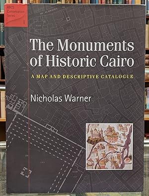
The Monuments of Historic Cairo: A Map and Descriptive Catalogue
Language: English
Published by The American University in Cairo Press, 2005
ISBN 10: 9774248414 ISBN 13: 9789774248412
First Edition
Hardcover. Condition: Very good. Dust Jacket Condition: Very good. Corer lightly bumped.
-

The Monuments of Historic Cairo: A Map and Descriptive Catalogue
Language: English
Published by The American University in Cairo Press, Cairo, Egypt, 2005
ISBN 10: 9774248414 ISBN 13: 9789774248412
First Edition
Hardcover. Condition: Fine. Dust Jacket Condition: Fine. First Edition. Second Printing. xv, 250 pp. Clean, crisp copy with dust jacket in mylar cover. 31 folding maps at rear, all in Fine condition.
-

Country Between Cairo And Suez Canal To Illustrate Military Operation 1882 [ 2 PAGE COLOUR MAP EXTRACTED FROM The Age We Live In : A History Of The Nineteenth Century ]
Published by William Mackenzie London, 1885
First Edition
US$ 34.25
US$ 26.60 shipping
Ships from United Kingdom to U.S.A.Quantity: 1 available
Add to basket1st edition. Narrow 4to. Map on thick paper with inset centre fold so no ragged edge from binding. Coloured in yellow, red & blue. Few slight fox marks to rear else very clean with sharp corners. VG+.
-
![Seller image for [6 items of ephemera pertaining to the Chicago World's Columbian Exposition of 1893] Leaflet with folding map. Program for Children's Day. Mammoth "Garland". Scrap of printed paper. Catalogue of Cliff Dwellers' Exhibit (loose covers). Street in Cairo. for sale by Joseph Burridge Books](https://pictures.abebooks.com/inventory/md/md32427515219.jpg)
[6 items of ephemera pertaining to the Chicago World's Columbian Exposition of 1893] Leaflet with folding map. Program for Children's Day. Mammoth "Garland". Scrap of printed paper. Catalogue of Cliff Dwellers' Exhibit (loose covers). Street in Cairo.
Published by H. Jay Smith Exploring Company, Hunt & Eaton, Midway Publishing et al, Chicago, 1893
Seller: Joseph Burridge Books, Dagenham, United Kingdom
Seller rating 5 out of 5 stars

First Edition
US$ 47.95
US$ 19.95 shipping
Ships from United Kingdom to U.S.A.Quantity: 1 available
Add to basketSoft cover. Condition: Very Good. 1st Edition. Leaflets, guides, ephemera etc.
-
Rare Map of the Oasis of Siwah from The Journal of Frederick Horneman's Travels, from Cairo to Mourzouk, the Capital of the Kingdom of Fezzan in Africa. In the Years 1797-8
Language: English
Published by G. and W. Nicol in, London, 1802
Map First Edition
US$ 164.39
US$ 39.90 shipping
Ships from United Kingdom to U.S.A.Quantity: 1 available
Add to basketNo Binding. Condition: Very Good. No Jacket. Major James Rennell (illustrator). 1st Edition, Illustrated Edition. This map is a page from the first English edition of The Journal of Frederick Horneman's Travels, from Cairo to Mourzouk. Published in London by G. and W. Nicol in 1802, this version included significant geographical illustrations by renowned cartographer Major James Rennell. In this edition, the main journal of Frederick Horneman's travels concludes on page 119. The section that follows contains several appendices and "Geographical Illustrations" written by Rennell. Horneman was the first European in modern times to traverse the north-eastern Sahara, making his first edition a highly sought-after item for collectors of African exploration. This was the first detailed European map of Siwah (the "Oasis of Ammon") based on first-hand modern observation. The map is intended to illustrate the descriptions of the ancient Temple of Jupiter Ammon ruins mentioned in the text. The image itself is described in a scholarly essay as coming from a drawing by a Marabut (scholar) of the indigenous Hausawa people and is thought to be the oldest native spatial conception of their West African homeland, Kasar Hausa. A quote from Hornemann reads: "As to what the inhabitants themselves call Hausa, I had as I think, very certain information. One of them, Marabut (scholar), gave me a drawing of the situation of the different regions bordering on each other, which I here give as I received it." This copy shows the indentation of the copper plate used to print Rennell's illustration and the paper contains the watermark of the papermill - JW HATMAN 1801- which verifies its source being the first English edition from 1802. The paper is bright with borders untrimmed and features the wide margins of the original quarto format there is some minor foxing to the upper right edge of the page (as photographed).
-
The Story of the Cape to Cairo Railway and River Route, from 1887 to 1922. In three volumes with seperate map case.
Published by London: The Pioneer Publishing Co. Ltd, 1923
Seller: Michael Graves-Johnston, ABA, ILAB, London, United Kingdom
Seller rating 5 out of 5 stars
First Edition
US$ 1,027.42
US$ 37.24 shipping
Ships from United Kingdom to U.S.A.Quantity: 1 available
Add to basketCompiled, Illustrated and Edited by Leo Weinthal. London: The Pioneer Publishing Co., Ltd., 1923 Publisher's gilt decorated black half-morocco, 4to. (1). The Record and romance of an Imperial Project; how it materialised to date; and the Story of its Creators. Forewords by J. C. Smuts, The Earl Buxton and Sir Francis Younghusband. viii,xxxvi,727pp. 351 plates, (10 coloured, 6 folding), numerous text illustrations, 17 photo plate insets, 8 maps, (1 folding). (2). The Main Line as it exists to-day from the Cape to the Nile Delta. ii,xx,510pp. 209 plates, (3 coloured, 9 folding), numerous text illustrations, 8 photo plate insets, 6 maps, (1 coloured folding). (3). Variations of the Main Trunk Route and its Feeder Lines in existence or projected. Africa's Native Tribes and Wild Game. ii,xvi,454pp. 152 plates, (6 coloured), numerous text illustrations, 5 photo plate insets, 6 maps, (2 coloured folding). (4). Index to volumes I., II. & III. ii,49pp. 2 plates, 13 maps, (12 folding, 11 coloured). A massive compilation on the countries of Africa along the route of the railway, the associate editors were Sir Alfred Sharpe, C. W. Hobley, Gerald H. Lepper, Charles Rudy, Alfred J. Clevely, Charles Sheldon, W. Ingram-Lyon and William J. Brand. Containing contributions by the famous africanists of the day. A fourth volume (not present here) "Supplementary to the Story of the Cape to Cairo Route, and dealing exclusively with the Finance, Commerce and Industry of the Countries served by the Route" was published in 1926. A very good copy of the first edition. We have been selling antiquarian books on Africa, Oceania, archaeology, anthropology, travel and the ancient world for over forty years. All our books are carefully catalogued and they are in excellent condition unless stated in the description. All shipments are fully insured at our expense. All books are carefully packaged in new packaging material and despatched by registered or recorded mail, or by a courier service; the customer is always able to track their shipment. All sales are accompanied by a VAT invoice. Photographs may be supplied if requested.[B].
-

Pharus-Map of Cairo 1:8000.
Language: English
Published by Pharus-Verlag (ca. 1912), Berlin, 1912
Seller: Antiquariat Düwal, Berlin, Germany
Association Member: GIAQ ILAB VDA
Seller rating 4 out of 5 stars

First Edition
Mehrfarbige Faltkarte im Maßstab 1:8000 (Kartengröße 104 x 78 cm) lose zusammen m. Alphabetical Street Index (16 S.) in OBrosch.-Umschlag m. zweifarbigem Deckeltitel Brosch.-Umschlag etw. lädiert m. Fehlstelle oben, Stempel der ausliefernden Buchhandlung H. Friedrich, Cairo auf dem Deckel. Karte m. kl. Einriß an Falzkanten, rückseitig teils schwache Wasserränder. Sonst wohlerhalten. gr.
-
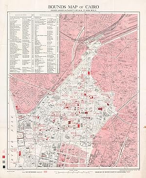
Bounds Map of Cairo Issued Under Authority of H. Q. 17 Area M. E. F.
Publication Date: 1945
Seller: Geographicus Rare Antique Maps, Brooklyn, NY, U.S.A.
Association Member: ABAA ESA ILAB
Seller rating 4 out of 5 stars
Map First Edition
1st Edition. Very good. Exhibits light wear along original fold lines. Blank on verso. Size 27 x 21.5 Inches. This is a 1945 British Army Survey of Egypt map of Cairo, Egypt, made for British use in World War II (1939 - 1945). Created as a resource for British soldiers stationed in Cairo, the map offers insights into British military life in Cairo during the War. A Closer Look Color coding defines zones permitted to British personnel and those that were strictly off limits. The white zones at the center of the map highlight where British soldiers could move freely, while pink zones were as 'out-of-bounds'. Red buildings 'in-bounds' highlight sites of interest for British personnel, including cinemas, the Royal Opera House, and numerous clubs. Other sites include the Y.M.C.A., the Royal Air Force Post Office, the Headquarters of British Troops in Egypt, and the British barracks. An index in the upper left lists the clubs, institutes, churches, museums, cinemas, theaters, and other important locations, along with the grid location of each. The British in Egypt The British occupation of Egypt began in 1882 after the Orabi Revolt. Britain remained in control of Egypt until 1922, when the British recognized Egyptian independence. Even after independence, British troops remained in Egypt to defend the Suez Canal. During World War II, British forces in North Africa operated out of Cairo, with hundreds of thousands of British troops passing through the city to engage Rommel's Afrika Korps. Cairo also hosted U.S. President Franklin D. Roosevelt, British Prime Minister Winston Churchill, and Chinese President Chiang Kai-shek for a conference to discuss the war against Japan and the future of Asia. Publication History and Census Two editions of this map were published. The first edition was created by the Survey of Egypt and published in 1943. The second edition, of which the present example is representative, was published in March 1945 by the 512 Field Survey Company of the Royal Engineers for the British Army. Nine examples are cataloged in institutional collections worldwide and are part of the collections at Columbia University, the Library of Congress, the University of Utah, the University of Oxford, the National Library of Israel, the University of Auckland, the National Library of New Zealand, Victoria University of Wellington, and the University of Queensland. References: OCLC 907554773.


