
Order Total (1 Item Items):
Shipping Destination:

Map Paris, First Edition (67 results)
Skip to main search results
Search filters
Product Type
- All Product Types
- Books (40)
- Magazines & Periodicals (2)
- Comics (No further results match this refinement)
- Sheet Music (No further results match this refinement)
- Art, Prints & Posters (2)
- Photographs (No further results match this refinement)
- Maps (19)
- Manuscripts & Paper Collectibles (4)
Condition Learn more
Binding
Collectible Attributes
Language (4)
Free Shipping
Seller Location
Seller Rating
-
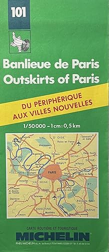
C1990s Michelin Map No. 101 Banlieue de Paris/Outskirts of Paris
Published by Michelin, Paris, 1985
Seller: 32.1 Rare Books + Ephemera, IOBA, ESA, Princeton, NJ, U.S.A.
Association Member: IOBA
Seller rating 4 out of 5 stars

Manuscript / Paper Collectible First Edition
Softcover. First Edition. Circa 1970s two-sided color map of the Toulouse region. 10" x 4 1/2" folding out to 48"x 10." Very Good with some light handling and wear.
-

The Mirror of Literature, Amusement and Instruction. March 1844. No 12, The Proposed Paris to Strasbourg Railway line (with map). DUELS, The Noble House of Arden (Arderne) with engraving of Coat of Arms.
Language: English
Published by John Mortimer, London, England,, 1844
Magazine / Periodical First Edition
Soft cover. Condition: Very Good. First Edition. 16pp. 8.5 x 6 inch. An original complete edition of this 16 page weekly magazine. In the title I have listed articles or pictures of interest in this issue. It may have occasional light foxing or age discolouration but having been disbound from a compilation it is still unfolded and in nice clean condition - no deliberate marks. It will be despatched in a board back envelope. If ordering more than one issue reductions on postage apply.
-

Plan de Paris + (verso) 2 Maps of France (Wall-Map Poster)
Language: English
Published by Scott, Foresman Co., Glenview IL, 1990
ISBN 10: 0673350673 ISBN 13: 9780673350671
First Edition
Condition: New. 1st edition thus. This is a 2-sided full-color wall map/poster from the publishers French Program, Level 2 #35067, one side with a map of France showing major cities plus another map of France showing its departements; the other (verso) side is a Plan de Paris showing major attractions and arrondissements. Rare item, brand new. Sleeve is 8-1/2 x 11, map unfolded is 22 x 34. 2-sided folded color map in cellophane sleeve w printed cover.
-

French Line Tourist Map of France with Sight-Seer Map of Paris, Motortour Map of North Africa
Language: English
Published by French Line, New York, 1930
Manuscript / Paper Collectible First Edition
Soft cover. Condition: Very Good. 1st Edition. Brochure of 32 panels, colour maps, folds out to measure 19 x 32", ready for framing, VG copy, issued in New York, photos, date is a guess.
-

Map of Paris, Au Bon Marche, The Rive Gauche Department Store
Published by Au Bon Marche, Paris, 1985
Seller: 32.1 Rare Books + Ephemera, IOBA, ESA, Princeton, NJ, U.S.A.
Association Member: IOBA
Seller rating 4 out of 5 stars
Manuscript / Paper Collectible First Edition
Softcover. Condition: Very Good. First Edition. Edition 87. 8" x 4" folding out to a 17" x 23" Paris street and Metro map.
-

Map of Paris, Printemps Department Store
Published by Printemps, Paris, 1985
Seller: 32.1 Rare Books + Ephemera, IOBA, ESA, Princeton, NJ, U.S.A.
Association Member: IOBA
Seller rating 4 out of 5 stars
Manuscript / Paper Collectible First Edition
Softcover. Condition: Very Good. First Edition. 8" x 4" folding out to a 17" x 23" Paris street and Metro map.
-
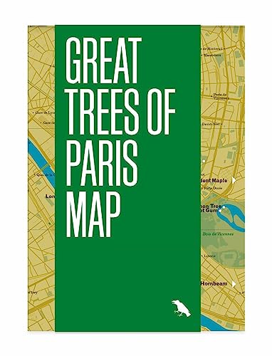
Great Trees of Paris Map: Guide to the Oldest, Rarest and Historical Trees of Paris: 3 (Great Trees Maps by Blue Crow Media)
Seller: Kennys Bookshop and Art Galleries Ltd., Galway, GY, Ireland
Seller rating 5 out of 5 stars

First Edition
Condition: New. 2023. 1st Edition. map. . . . . .
-

Art Deco Paris Map / Carte Paris Art D?co: Guide to Art Deco architecture in Paris
Seller: Kennys Bookshop and Art Galleries Ltd., Galway, GY, Ireland
Seller rating 5 out of 5 stars
First Edition
Condition: New. 2025. 1st Edition. map. . . . . .
-
EARLY MAPS OF GREAT BRITAIN: 1. THE MATTHEW PARIS MAPS; II. THE GOUGH MAP; III. AEGIDIUS TSCHUDI'S MAPS
Published by Geographical Journal, London, 1933
Magazine / Periodical First Edition
Pamphlet. Condition: Very Good. 1st Edition. Vol 81, No 1, January, 1933, pp. 27-45+ 2 Map Plts & Lge FoldOut Map (12 x 17 Inches), Extracted from orig vol, begins with title page, trimmed & stapled, thus is like a pamphlet, last page in facsimile, else VG.
-
![Seller image for Comment sortir de Paris / edite par la Compagnie Industrielle des Petroles [vintage routefinder / map - Paris/France - circa 1940s] for sale by MW Books](https://pictures.abebooks.com/inventory/md/md14221203845.jpg)
Comment sortir de Paris / edite par la Compagnie Industrielle des Petroles [vintage routefinder / map - Paris/France - circa 1940s]
Published by Compagnie Industrielle des Petroles, circa 1930s/1940s, 1940
First Edition
First Edition. The route planner is in a very good condition, with some minor stain marks and edge dulling. Further scans, images etc. and additional bibliographical material available on request.; 8vo 8" - 9" tall; 1 pages; A vintage route planner showing routes out of Paris to various destinations in France. Circa 1930s/1940s. 17 x 12cm. Folds out to 34 x 12cm. Sponsored by CIT Motricine. Language: French. Contents include a map of Paris with a sliding guide underneath. Subjects: Cars and car travel -- History -- Automobiles -- Routefinders -- Route planners -- Transport and transporation -- History. 3 Kg.
-
Paris Metro Style: In Map and Station Design
Language: English
Published by Capital Transport Publishing, Harrow, 2008
ISBN 10: 1854143220 ISBN 13: 9781854143228
First Edition
US$ 34.55
US$ 26.83 shipping
Ships from United Kingdom to U.S.A.Quantity: 1 available
Add to basketHardcover. Condition: Fine. 1st Edition. 2008 first edition hardback. In excellent clean condition appears hardly used.
-
MAP: DE LA SOMME A LA MER BY A TARIDE , EDITEUR, PARIS , 50 V 70 CMS . COLOURED , VERY GOOD CONDITION,
Language: English
Published by A TARIDE, 1920
Seller: K Books Ltd ABA ILAB, York, YORKS, United Kingdom
Association Member: ABA ILAB PBFA
Seller rating 5 out of 5 stars
First Edition
US$ 20.73
US$ 26.16 shipping
Ships from United Kingdom to U.S.A.Quantity: 1 available
Add to basketSoft cover. Condition: Very Good. 1st Edition. MAP: DE LA SOMME A LA MER BY A TARIDE , EDITEUR, PARIS , 50 V 70 CMS . COLOURED , VERY GOOD CONDITION,
-
![Seller image for Marie Walewska: Napoleon's Great Love [Map of Europe in 1812 - Chaos and magnificence -- The Manor -- Anastase -- The French are coming -- The courtship -- The idyll -- l -- A visit to Paris -- Wagram -- Alexander -- The Russian nemesis -- Paris in 1813 -- Elba -- The hundred days] for sale by Joseph Valles - Books](https://pictures.abebooks.com/inventory/md/md32352779089.jpg)
Marie Walewska: Napoleon's Great Love [Map of Europe in 1812 - Chaos and magnificence -- The Manor -- Anastase -- The French are coming -- The courtship -- The idyll -- l -- A visit to Paris -- Wagram -- Alexander -- The Russian nemesis -- Paris in 1813 -- Elba -- The hundred days]
Language: English
Published by Vendome Press : distributed by Viking Press, New York, 1979, 1979
ISBN 10: 0670284734 ISBN 13: 9780670284733
Seller: Joseph Valles - Books, Stockbridge, GA, U.S.A.
Seller rating 5 out of 5 stars
First Edition
Hardcover. Condition: Fine. Dust Jacket Condition: Very Good. 1st Edition. 265 p., [2] leaves of plates : ill. ; 24 cm. ; ISBN 9780670284733, 0670284734 OCLC 5689322 ; LCCN 79005092 LC DC204 .S94 ; Dewey 944.050924 ; green cloth in color pictorial dustjacket ; Christine Sutherland grew up in Poland and in France, and speaks both languages fluently. She was an editor and writer for the Reader's Digest in the United States and while there published, as Christine Hotchkiss, two books, Home to Poland and A Boy Called Tony. She was the London editor of Horizon for nie years, is married to David Sutherland, a Scot, and lives in London and Scotland ; Marie Walewska was a Polish countess who became a significant and beloved mistress of Napoleon Bonaparte. Their relationship, which began in 1807, was passionate and produced a son, Alexandre, born in 1810. It also had political significance, as Walewska's influence may have encouraged Napoleon to create the Duchy of Warsaw and was marked by her deep love for her country, Poland. ; Contents: Map of Europe in 1812 - Chaos and magnificence -- The Manor -- Anastase -- The French are coming -- The courtship -- The idyll -- l -- A visit to Paris -- Wagram -- Alexander -- The Russian nemesis -- Paris in 1813 -- Elba -- The hundred days; nicks to edge of dustjacket, else FINE/VG. Book.
-
Cartes Taride Routieres, Lorraine, Luxembourg. First Edition. Map in Envelop. Circa Mid 1920's. Paris
Published by Cartes Taride, Paris
First Edition
Condition: Very Good. Map Illustrations (illustrator). First Edition. Original envelope contiaining motoring maps of Lorraine and Luxembourg. Very scarce.
-
Map of "France - North-Western Section" from 1920 Times Atlas (Plate 28) covering Paris, Rouen, Le Havre, Rennes, Le Mans, Brest, Nantes, Angers, Tours and Poitiers and including the Channel Islands and an inset plan of Paris
Published by The Times, London, 1920
First Edition
US$ 24.32
US$ 19.45 shipping
Ships from United Kingdom to U.S.A.Quantity: 1 available
Add to basketSoftcover. Condition: Very Good. Dust Jacket Condition: No Dust Jacket. First Edition. Disbound single sheet with vertical centre fold from the 1920 "The Times Survey Atlas of the World". Map is in colour and suitable for framing. Colour is according to contour, boundaries of departments are in red. Map at scale 1:1,000,000 with small inset plans of Paris, Le Havre and Brest. Map covers the north western departments of France and includes the Channel Islands, Paris, Rouen, Le Havre, Rennes, Le Mans, Brest, Nantes, Angers, Tours, Poitiers, Amiens, Dieppe, Orleans, Cherbourg, Quimper, La Roche, Chateauroux, etc. Slightly darkened edges with occasional very light foxing in the margins. Sheet is otherwise crisp, clean and bright. Size: 46cm x 58cm approx. Quantity Available: 1. Shipped Weight: under 1 kg. Pictures of this item not already displayed here available upon request. Inventory No: 45020044006. All our books are sent by tracked mail.
-
Map of "France - North-Eastern Section" from 1920 Times Atlas (Plate 29) covering Paris, Orleans, Moulins, Nevers, Troyes, Riems, Nancy, Dijon, Strasbourg, Mulhouse, Besancon, Luxemburg, Mannheim, Basel and Bern
Published by The Times, London, 1920
First Edition
US$ 24.32
US$ 19.45 shipping
Ships from United Kingdom to U.S.A.Quantity: 1 available
Add to basketSoftcover. Condition: Very Good. Dust Jacket Condition: No Dust Jacket. First Edition. Disbound single sheet with vertical centre fold from the 1920 "The Times Survey Atlas of the World". Map is in colour and suitable for framing. Colour is according to contour, boundaries of departments and countries are in red. Map at scale 1:1,000,000. Map covers the north eastern departments of France and parts of Belgium, Germany and Switzerland and includes Paris, Orleans, Moulins, Nevers, Troyes, Riems, Nancy, Metz, Dijon, Strasbourg, Mulhouse, Besancon, Luxemburg, Mannheim, Basel, Bern, etc. Slightly darkened edges with occasional very light foxing in the margins. Bottom edges at corners are slightly roughened. Sheet is otherwise crisp, clean and bright. Size: 46cm x 58cm approx. Quantity Available: 1. Shipped Weight: under 1 kg. Pictures of this item not already displayed here available upon request. Inventory No: 45020044007. All our books are sent by tracked mail.
-
VanDam 'Europe Unfolds' Map Set (1984) - London, Paris & Rome, First Edition
Language: English
Published by ProDesign Inc. / World Unfolds Publishing Ltd., 1984
Map First Edition
Soft cover. Condition: Near Fine. 1st Edition. VanDam, Stephan (designer). London Unfolds; Paris Unfolds; Rome Unfolds. New York: ProDesign Inc. / World Unfolds Publishing Ltd., 1984. First Edition, First Printing. Original 1984 Europe Unfolds travel map set designed by Stephan VanDam for ProDesign Inc., featuring the innovative 'Unfolds' - patented format (U.S. Patent No. 4,502,711). Includes three laminated foldout maps: London Unfolds, Paris Unfolds, and Rome Unfolds, each listing hotels, restaurants, museums, galleries, nightlife, and cultural attractions. The striking black minimalist covers with diagonal-line design represent early examples of VanDam's influential modernist cartographic style that later evolved into his StreetSmart series. Published by World Unfolds Publishing Ltd., this is the inaugural 1984 issue (marked 'Patent Pending' and printed before the rebranded VanDam/StreetSmart editions). Maps are bright, clean, and fully functional, showing only light creasing at folds; housed in the original clear vinyl slipcase, lightly clouded but intact. A scarce complete tri-city set and an iconic artifact of 1980s graphic design and urban travel culture. Stephan VanDam (b. 1950) is a New York-based cartographer and designer known for his patented pop-out 'Unfolds' and StreetSmart maps, which fuse urban data with modernist clarity. His works are held in the permanent collections of the Museum of Modern Art (MoMA) and the Cooper Hewitt Smithsonian Design Museum.
-
![Seller image for Comment sortir de Paris / edite par la Compagnie Industrielle des Petroles [vintage routefinder / map - Paris/France - circa 1940s] for sale by MW Books Ltd.](https://pictures.abebooks.com/inventory/md/md14271410467.jpg)
Comment sortir de Paris / edite par la Compagnie Industrielle des Petroles [vintage routefinder / map - Paris/France - circa 1940s]
Published by Compagnie Industrielle des Petroles, circa 1930s/1940s, 1940
First Edition
First Edition. The route planner is in a very good condition, with some minor stain marks and edge dulling. Further scans, images etc. and additional bibliographical material available on request.; 8vo 8" - 9" tall; 1 pages; A vintage route planner showing routes out of Paris to various destinations in France. Circa 1930s/1940s. 17 x 12cm. Folds out to 34 x 12cm. Sponsored by CIT Motricine. Language: French. Contents include a map of Paris with a sliding guide underneath. Subjects: Cars and car travel -- History -- Automobiles -- Routefinders -- Route planners -- Transport and transporation -- History. 1 Kg.
-

Condition: Wie neu. 1. Aufl. 152 S. + Kt.-Beil. ([2] S.) Alle B�cher & Medienartikel von Book Broker sind stets in gutem & sehr gutem gebrauchsf�higen Zustand. Die Ausgabe des gelieferten Exemplars kann um bis zu 10 Jahre vom angegebenen Ver�ffentlichungsjahr abweichen und es kann sich um eine abweichende Auflage handeln. Unser Produktfoto entspricht dem hier angebotenen Artikel, dieser weist folgende Merkmale auf: Helle/saubere Seiten in fester Bindung. Mit Beilage. Sprache: Deutsch Gewicht in Gramm: 240 Taschenbuch, Ma�e: 12.3 cm x 1.4 cm x 18.1 cm.
-
Map of Paris
Published by Blondell La Rougery, Paris, France, 1944
Seller: Ground Zero Books, Ltd., Silver Spring, MD, U.S.A.
Seller rating 5 out of 5 stars
First Edition
Map. Condition: Fair. Full color map of Paris, measuring 14 inches by 21 inches, folded into a pocket size 3 inches by 5 inches. Includes information on the routes of the Paris-Metro, American Red Cross Clubs; places to see; how to ask your way [ask for directions]. Has some vocabulary in French and English, with some pronunciation guidance. Provides some general information. Provides information on Public Administration Buildings, Railroad Stations, Academic Buildings, Parks, Sports, Music-Halls, Main Buildings, Museums, Religious Services, This map was permitted to be mailed back to the U.S. if 'unmarked'. Copyright was held by Blondel La Rougery, Paris, 1944. It has the Depot Legal No. 36-1-45-8449, Also contains part map of Calahorra, Spain in German on the reverse side. Calahorra La Rioja, Spain is a municipality in the comarca of Rioja Baja, near the border with Navarre on the right bank of the Ebro. This map was printed on a recycled German map due to the paper shortage in ETO. Map has wear at folds, with some small tears and chips. Blondell La Rougery was a noted French cartographic publisher. Presumed First Edition, First printing thus.
-
Handbook to Paris and its Environs, with plan of the city, map of the environs, plans of the Bois de Boulogne, ., and a map of the battlefields
Published by Ward Lock & Co. London c.1920, 1920
Seller: Andrew Barnes Books / Military Melbourne, Melbourne, VIC, Australia
Seller rating 4 out of 5 stars
First Edition
12th edition hardback with dust jacket Nice copy small octavo 224pp., colour maps & plans, vocabulary, index, First edition after the Great War. Several folding maps & plans in first class order. Uncommon in dust jacket.
-
Paris: Past and Present (First Edition | Map | Color Plates)
Published by "The Studio" Ltd., Lond, Paris, new York, 1915
First Edition
Quarter Buckram. Condition: Good. First Edition. FIRST EDITION, first printing. Quarter grey buckram hardcover with dark green lettering on the front cover. viii, 166 pp + numerous plates (8 in colour), double page plan of Paris ca. 1630 at front. Overall a GOOD book. Size: 4to - over 9�" - 12" tall. Hardcover.
-
The Illustrated London News Vol XLVIII July To Dec 1865. UNFOXED CLEAN PLATES DOUBLE PAGE VIEW OF " THE PARIS EXHIBITION BUILDING AND GROUNDS " & " VIEW OF FLORENCE " & " Laying The Atlantic Cable" , New Zealand , West Indies , " Telegraph Map of the Eastern World " BUT LACKS TWO COLOUR PLATES, ARTICLES ON " RUSSIA AND CRIMEA "
Language: English
Published by George C Leighton London, London, 1865
First Edition
US$ 276.36
US$ 26.83 shipping
Ships from United Kingdom to U.S.A.Quantity: 1 available
Add to basketCondition: Good. 1st edition. Folio. iv + 660pp. Double page panoramas of Richmond Virginia after its capture by The Federals, double page birds eye view of Paris Exhibition, Florence, several articles on Laying The Atlantic Cable, New Zealand, West Indies, Telegraph Map of the Eastern World. Lacks two colour plates, missing from wallet on rear paste down. Numerous bw engravings. Original publisher's light green blind stamped cloth with gilt cartouche of two soldiers shaking hands + gilt lettering on front, gilt lettering and device on spine. Green eps. Covers rubbed and worn, 0.5cm chips top/bottom spine. A few marks but generally contents unfoxed, clean & tight. G+/VG cover/contents.
-

Anglo-Saxon Guide To The Paris Exhibition, 1900 : With Map Of Paris, Map Of The Exhibition Grounds & Buildings, Enlarged Plans Of The Various Sections : Upward Of 100 Illustrations And 10 Maps (Advance Edition)
Language: English
Published by Boot & Son; Impremieries Lemercier / Leonard Darbyshire, London / Paris / New York, 1900
Seller: Arroyo Seco Books, Pasadena, Member IOBA, Pasadena, CA, U.S.A.
Association Member: IOBA
Seller rating 4 out of 5 stars
Map First Edition
Soft cover. Condition: Good. Maps, Drawings, Photographs (illustrator). 1st Edition. 232 Pp. Card Covers In Orange, Green And Black Over White. Very Detailed Albeit Overly Promotional. Scarce; Worldcat Shows Only 3 Institutional Holdings. Covers Worn, Front And Rear Covers Detached But Present, Contents Clean And Unmarked.
-
PLAN DE L'ENTREE DU PORT DE BUCARELLI sur la Cote du Nord-Ouest de l'Amerique, par 55 degrees 15' de Latitude Nord et 136 degrees 15' de Longitude a l'Ouest de Paris. [map]
Language: English
Published by La Perouse, Paris, 1797
Seller: Kurt Gippert Bookseller (ABAA), Chicago, IL, U.S.A.
Association Member: ABAA ILAB MWABA
Seller rating 5 out of 5 stars
Map First Edition
Unbound. Condition: Very good+ condition. First Edition. A large map, beautifully decorated with original outline color. The map is included in the Atlas volume of La Perouse's Voyages, but was drawn from Spanish manuscripts as it was thought that it might be a part of the Northwest Passage. The map has an extra vertical crease from mis-folding, but is quite clean and has large margins, which are lightly soiled here and there.
-
PARIS NOUVEAU, 1855 [Map - carte].
Language: English
Published by Furne, Paris, France, 1855
Seller: Kurt Gippert Bookseller (ABAA), Chicago, IL, U.S.A.
Association Member: ABAA ILAB MWABA
Seller rating 5 out of 5 stars
Map First Edition
Hardcover. Condition: Very good condition. First Edition. Pocket map; folding map of Paris. Measures approximately 27 inches height x 35 width (686mm x 890mm). Original outline hand-color. Numerous small tears at folds, with overall slight to moderate browning to folds. An attractive map, bound in the original dark blue cloth and paper-covered case with leather spine label. Map is dissected and linen-backed (by publisher); linen is slightly soiled, and is separated at several folds. 32 page index (slightly foxed) precedes the map. Previous owner's name on front endpaper. States: Dresse par A. Vuillemin, Ingenr. Geographe; Imp. F. Chardon Aire, 30 r. Hautefeuille, Paris; Grave par Jacobs et Barthelemier Freres; Publie par Furne, a Paris, 15 rue St. Andres-des-Arts.
-
![Seller image for Plan Routier de la Ville de Paris, Divise en douze Arrondissemens. [map] for sale by Kurt Gippert Bookseller (ABAA)](https://pictures.abebooks.com/inventory/md/md6669219670.jpg)
Plan Routier de la Ville de Paris, Divise en douze Arrondissemens. [map]
Language: English
Published by Terry, Paris, 1830
Seller: Kurt Gippert Bookseller (ABAA), Chicago, IL, U.S.A.
Association Member: ABAA ILAB MWABA
Seller rating 5 out of 5 stars
Map First Edition
Hardcover. Condition: Very good- condition. First Edition. Pocket map; folding map of Paris. Measures approximately 17 inches height x 24 width (432mm x 610mm). Original outline hand-color designates districts of the city. Numerous tears at folds, with extensive early archival repairs applied to reverse. An attractive map, bound in the original paper-covered case with printed front cover label; heavily worn and tape repaired.
-
Nouveau Plan de la Ville de Paris, Divise en 12 Arrondissemens et 48 Quartiers. [map]
Language: English
Published by Jean, Paris, 1846
Seller: Kurt Gippert Bookseller (ABAA), Chicago, IL, U.S.A.
Association Member: ABAA ILAB MWABA
Seller rating 5 out of 5 stars
Map First Edition
Hardcover. Condition: Very good- condition. First Edition. Pocket map; folding map of Paris. Measures approximately 23 inches height x 34 width (585mm x 864mm). Original outline hand-color designates districts of the city. Numerous small tears at folds, with overall slight to moderate browning to folds. Illustrated with four vignettes of famous monuments at the four corners of the image area. An attractive map, bound in the original dark blue paper-covered case; small section of tape on front cover, with overall moderate wear.
-
The Illustrated London News Vol LXXII Jan To June 1878 VERY CLEAN, TIGHT AND UNFOXED STANLEY UP THE NILE , PLEVNA SIEGE , COLOUR PLATE AND ARTICLE CLEOPATRA'S NEEDLE , ARUWIMI RIVER WAR , BRITISH FLEET IN THE DARDENELLES , DOUBLE PAGE PLATE YORK MINSTER , DOUBLE PAGE SKETCH MAP DARDENELLES , EURYDICE IN SQUALL , PARIS EXHIBITION , THIRLMERE , FOLKESTONE COLLISION
Language: English
Published by George C Leighton London, London, 1878
First Edition
US$ 621.82
US$ 26.83 shipping
Ships from United Kingdom to U.S.A.Quantity: 1 available
Add to basketCondition: Very Good. 1st edition. Folio. iv + 616pp. Colour plate Cleopatra's Needle AtWestminster, double page colour plate Sketch map From The Dardanelles To The Bosphorus, double page 31st Native Infantry & Bengal Calvary, Special numbers Stanley in Africa, The Kaffir War, Paris Exhibition, Malta, Congress Of Berlin, Russia Turkey war. Lacks both colour plates + 3 minor bw supplement plates. Numerous bw engravings. Original publisher's light green blind stamped cloth with gilt cartouche of togaerd beauties holding up laurel leaves + gilt lettering on front, gilt lettering and device on spine. Orange eps. Covers rubbed and marked, spine fading, water stain around edges, and worn, 0.5cm chips top/bottom spine. A few marks but generally contents clean & tight. G+/VG cover/contents.
-
The Illustrated London News Vol XLII Jan To June 1863 CLEAN TIGHT UNFOXED PAGES DOUBLE PAGE COLOUR PLATE " THE PEER'S LOBBY " PLUS LONG ARTICLE / PLATES ON THE US / AMERICAN CIVIL WAR , VICTORIA VANCOUVER , TURNER SNOIWSTORM , SUEZ CANAL . CHINA WAR , CORFU VIEWS . DENMARK DOUBLE PAGE MAP , GRAVESEND DOUBLE PAGE SHIPS . EDINBURGH FIRE , DOGS SHOW PARIS , EPSOM RACES ,EMBANKMENT , VIRGINIA MAP
Language: English
Published by George C Leighton London, London, 1863
First Edition
US$ 621.82
US$ 26.83 shipping
Ships from United Kingdom to U.S.A.Quantity: 1 available
Add to basketCondition: Very Good. 1st edition. Folio. iv + 616pp. Double page colour plate Lobby At Westminster, The American Civil War, Charlseton, Mexico City, The Suez Canal. Lacks 2 colour plates. Numerous bw engravings. Original publisher's light green blind stamped cloth with gilt cartouche of side portrait of royal copy + gilt lettering on front, gilt lettering and device on spine.Olive eps. Covers rubbed, water stained and marked, spine fading, 0.5cm chips top/bottom spine, rear internal hinge detaching. Contents clean & tight. G/VG cover/contents.


![Seller image for PARIS NOUVEAU, 1855 [Map - carte]. for sale by Kurt Gippert Bookseller (ABAA)](https://pictures.abebooks.com/inventory/md/md6669219672.jpg)

