Order Total (1 Item Items):
Shipping Destination:

Colby Colonel (19 results)
Skip to main search results
Search filters
Product Type
- All Product Types
- Books (18)
- Magazines & Periodicals (No further results match this refinement)
- Comics (No further results match this refinement)
- Sheet Music (No further results match this refinement)
- Art, Prints & Posters (No further results match this refinement)
- Photographs (No further results match this refinement)
- Maps (1)
- Manuscripts & Paper Collectibles (No further results match this refinement)
Condition Learn more
Binding
Collectible Attributes
- First Edition (3)
- Signed (No further results match this refinement)
- Dust Jacket (1)
- Seller-Supplied Images (8)
- Not Print on Demand (18)
Language (2)
Free Shipping
Seller Location
Seller Rating
-
Large linen backed multi folding map of Parts of Carmarthenshire Brecknockshire & Glamorganshire. (so stated on cover)
Language: English
Published by Ordnance Survey, United Kingdom, 1882
Seller: Carmarthenshire Rare Books, Carmarthen, United Kingdom
Seller rating 5 out of 5 stars

US$ 20.60
US$ 22.67 shipping
Ships from United Kingdom to U.S.A.Quantity: 1 available
Add to basketHardcover. Condition: Very Good. Dust Jacket Condition: Paperback. 2nd Edition. second edition? original gilt lettered cloth covers with, large linen backed multi folding map measuring 98cm by 65cm, a very clean copy. We are a real bookshop with real books situated in and shipping from the United Kingdom. Shelf HC1.
-

US$ 34.34
US$ 24.67 shipping
Ships from United Kingdom to U.S.A.Quantity: 1 available
Add to basketHardcover. Condition: As New. Dust Jacket Condition: Fine. Small demy 4to, [xii], 336, 16, [7], [3] p. Eleven plates. Original red boards, gilt. An as new copy in a fine dust jacket. Originally published in Dublin in 1837. Facsimile edition.
-
US$ 89.28
US$ 30.00 shipping
Ships from United Kingdom to U.S.A.Quantity: 1 available
Add to basketSoft cover. Condition: Very Good. 1843.First edition? Folding linen backed map opening to 96 x 64cm. 1": 1 mile. Images available on request.
-

US$ 51.35
US$ 86.68 shipping
Ships from United Kingdom to U.S.A.Quantity: Over 20 available
Add to basketPaperback. Condition: New.
-
Ordnance Survey of the County of Londonderry. Memoir of the City and North Western Liberties of Londonderry. Parish of Templemore (Volume the First)
Language: English
Published by Published by Her Majesty's Government by Hodges and Smith, 1837
Seller: Shelley and Son Books (IOBA), Hendersonville, NC, U.S.A.
Association Member: IOBA
Seller rating 5 out of 5 stars
First Edition
Hardcover. Condition: Very Good -. First Edition. Paneled cloth (dampstained). Spine chipped and clear taped from head to tail. Ex-library. Hand-colored geological map of the Parish of Templemore. Folding plan of the City of Londonderry. Eight additional plans: one view, plus seven natural history plates (two hand-colored). 336; 16pp., index, plates. Full refund if not satisfied.
-
CARMARTHENSHIRE 41.
Published by Ordnance Map Office 1st June, 1831
Seller: Francis Edwards ABA ILAB, Hay on Wye, United Kingdom
Association Member: ABA ILAB PBFA
Seller rating 5 out of 5 stars
US$ 37.78
US$ 25.34 shipping
Ships from United Kingdom to U.S.A.Quantity: 1 available
Add to basketSegmented map measuring 75 cm. x 66cm. Some wear to marbled Edges. US$37.
-
Ordnance Survey Of The County Of Londonderry Volume The First [only]
Published by Hodges and Smith, Dublin, 1837
Seller: Willis Monie-Books, ABAA, Cooperstown, NY, U.S.A.
Association Member: ABAA ESA ILAB
Seller rating 5 out of 5 stars
First Edition
Hardcover. Condition: Poor. First Edition. Ex-library copy. Binding has considerable wear, a binding tape spine, and impressed library name. Covers are detached. Binding is shaken with pages loose or split into sections. Working copy for research, reading, or rebinding. ; Volume One, the only volume that was published. Covers the city and north western liberties of Londonderry and the Parish of Templemore.
-
CAERNARVONSHIRE, FLINTSHIRE DENBIGHSHIRE. 1 inch to 1 mile scale.
Published by Ordnance Map Officer, 1867
Seller: Francis Edwards ABA ILAB, Hay on Wye, United Kingdom
Association Member: ABA ILAB PBFA
Seller rating 5 out of 5 stars
US$ 113.32
US$ 25.34 shipping
Ships from United Kingdom to U.S.A.Quantity: 1 available
Add to basketElectrotyped Reprint of 1839/40 Ed. Linen backed segmented folding map measuring 140 x 98 cms. (55 x 38 inches). Some browning, folding into brown cloth boards, faded and frayed, loss to backstrip. US$111.
-
SNOWDEN & ITS NEIGHBOURHOOD.
Published by April 1, 1841
Seller: Francis Edwards ABA ILAB, Hay on Wye, United Kingdom
Association Member: ABA ILAB PBFA
Seller rating 5 out of 5 stars
US$ 151.09
US$ 25.34 shipping
Ships from United Kingdom to U.S.A.Quantity: 1 available
Add to basketLinen backed segmented map measuring 68 x 97cm. Some browning, folding into gilt lettered cloth, some wear. Ordnance Map Office. US$147.
-
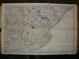
Ordnance Survey of England and Wales. Part of Essex - No. 48 Colchester
Published by Published by Edward Stanford, London, 1868
Seller: Keoghs Books, Skipton, United Kingdom
Association Member: PBFA
Seller rating 5 out of 5 stars
US$ 137.35
US$ 37.34 shipping
Ships from United Kingdom to U.S.A.Quantity: 1 available
Add to basket, hand coloured linen backed Colonel Colby panel map in slipcase Early Reprint , the map has a damp mark to cloth at rear which does not show on any of the panels, in very good condition , the slipcase is faded at edges, and has a 1.5cm crack at the upper head corner and a 0.5cm crack at the lower head corner, very good condition , red cloth covered slipcase, yellow title paper with black lettering tipped to upper , 17.5cm x 13.5cm (folded), 69 x 102 cm (open) Map ISBN:
-
Liverpool. Milit�rkarte. Massstab 1:4 Meils.
Published by London, 1st. October 1842., 1842
Seller: Biblion Antiquariat, Z�rich, ZH, Switzerland
Association Member: GIAQ ILAB VEBUKU
Seller rating 5 out of 5 stars
66x88 cm. Gestochene Karte, bestehend aus 36 Segmenten, auf Leinen aufgezogen. Engraved in the Towr of London at the Ordnance Map Office. The Outline by E. George, and J. Adkins, the Writting by J.A. Harrison, the Hills by R. Tovey, the Water by B. Baker and Published by Colonel Colby FRS.L&E. M.R.I.A., &c. October 1st 1842.
-
Sutton Coldfield, Lichfield & District
Published by Ordnance Survey Office, London, 1876
Seller: Rooke Books PBFA, Bath, United Kingdom
Association Member: PBFA
Seller rating 5 out of 5 stars
US$ 171.69
US$ 26.66 shipping
Ships from United Kingdom to U.S.A.Quantity: 1 available
Add to basketCloth. Condition: Good. Lieut. Colonel Colby [Thomas Frederick Colby]; Benjamin Baker (illustrator). A very scarce Ordnance Survey map depicting Sutton Coldfield, Lichfield, and the surrounding region, completed by cartographer Thomas Frederick Colby. This copy of this very scarce map was electrotyped in 1876, from a map first engraved and published on January 9th, 1834.Unfolded, the map measures approx. 29.5" by 37.5".This map of the West Midlands of England was engraved under the direction of Thomas Frederick Colby, a British major-general and director of the Ordnance Survey, by Benjamin Baker and his assistants.Printed in partial colour.Rebound in cloth, the map is linen backed.Small neat pencil notations to margins.A wonderful and very scarce map, offering an impressive level of detail. Rebound in cloth, with typed label to front board. Rubbing to board perimeters. Light tide marks to tail of front board. Internally, firmly bound. The map is backed with linen. Map a touch age toned, with instances of light handling marks, and the odd marginal pencil notation. Good. book.
-
ORDINANCE SURVEY OF THE COUNTY OF LONDONDERRY VOLUME THE FIRST; MEMOIR OF THE CITY AND NORTH WESTERN LIBERTIES OF LONDONDERRY: PARISH OF TEMPLEMORE
Published by Published for Her Majesty's Government by Hodges and Smith, Dublin, Ireland, 1837
Seller: Aardvark Rare Books, EUGENE, OR, U.S.A.
Seller rating 5 out of 5 stars
Hardcover. Condition: Good Plus. Folio. Brown paneled cloth over boards with blind ruling, and embossed i mage of three cannon to top board. Some wear to extremities, but solidly bound. Rebacked with most of original laid down, and replacement endpapers. Hand-colored, four-color Geological Map (1 inch to 1 Mile) of the Parish of Templemore. Folding plan of the City of Londonderry (1835). Eight other plans: one view. 80 p. History. section. 7 natural history plates. Other sections on Buildings, Municipality, Education, Benevolence, Justice, Community, Townlands, Antiquities, Social & Productive Economy, Errata page with Corrigenda; Detailed Index. NOTICES Section at rear included: ".for the more speedy information of men of science, in anticipation of the parochial memoirs." and cover Geology, Botany, Zoology, and include 7 full page natural history plates, of which two are in color. Printed by Graisberry. With inked deaccession stamp of King's College opposite preface. 336 and 16 and plates. Notes to check and paraphrase: . Hand-colored geological map of the Parish of Templemore. Eight additional plans: one view, plus seven natural history plates (two hand-colored). 336; 16pp., index, plates.
-
Ordnance Survey of the County of Londonderry. Memoir of the City and North Western Liberties of Londonderry. Parish of Templemore.
Published by 1st ed Published for Her Majesty's Government by Hodges and Smith Dublin, 1837
First Edition
US$ 336.51
US$ 24.67 shipping
Ships from United Kingdom to U.S.A.Quantity: 1 available
Add to basketHardcover. Condition: Very Good. 1st Edition. Large crown4to, 336, 16 p. A hand-coloured geological map of the Parish of Templemore, a folding plan of the City of Londonderry, eight additional plans, one view, plus seven natural history plates (two hand-coloured). Original blind-stamped dark brown cloth, gilt, pale yellow endpapers. Some signatures proud, light tanning to the edges of three of the seven plates and the City plan, small frays and a half inch split to the cloth of the lower joint otherwise a VG copy. First edition.
-
Condition: Good. 1837. Hardcover. Lightly scored copy rebound in quarter leather over cloth boards. Gilt title to spine. Showing some light shelf wear but remains a good copy. . . . . Books ship from the US and Ireland.
-
Ordnance Survey of the County of Londonderry: Memoir of the City and North Western Liberties of Londonderry, Volume the First; Parish of Templemore
Published by Hodges and Smith, 1837
Seller: Kennys Bookshop and Art Galleries Ltd., Galway, GY, Ireland
Seller rating 5 out of 5 stars
Condition: Good. 1837. Hardcover. Lightly scored copy rebound in quarter leather over cloth boards. Gilt title to spine. Showing some light shelf wear but remains a good copy. . . . .
-
Ordnance Survey Geological Sheet 36 Glamorganshire
Published by Published by Ordnance Survey and Edward Stanford, London, 1884
Seller: Keoghs Books, Skipton, United Kingdom
Association Member: PBFA
Seller rating 5 out of 5 stars
Map
US$ 206.03
US$ 37.34 shipping
Ships from United Kingdom to U.S.A.Quantity: 1 available
Add to basket, large hand coloured linen backed geological map one inch to a mile Revised edition , manuscript reference key to map, light marking, map in very good condition , slipcase rubbed at corners and marked, good condition , 69 x 193 cm (open), 24 x 17 cm (folded) Map ISBN:
-
Condition: Scace. First. Ex Dromoland Castle - Volume the first (all published) p.p. 336 - 16 + 7 pages of plates, 4 coloured. Folding map. Quarto. Original decorative cloth with cannons on covers.Ex Dromoland Castle Library, signed on end paper Lucius O'Brien", Dromoland.
-

Condition: New. Dieser Artikel ist ein Print on Demand Artikel und wird nach Ihrer Bestellung fuer Sie gedruckt. KlappentextrnrnThis book has been considered by academicians and scholars of great significance and value to literature. This forms a part of the knowledge base for future generations. So that the book is never forgotten we have represented this.