Order Total (1 Item Items):
Shipping Destination:

Danckwerth (33 results)
Skip to main search results
Search filters
Product Type
- All Product Types
- Books (27)
- Magazines & Periodicals (No further results match this refinement)
- Comics (No further results match this refinement)
- Sheet Music (No further results match this refinement)
- Art, Prints & Posters (4)
- Photographs (No further results match this refinement)
- Maps (2)
- Manuscripts & Paper Collectibles (No further results match this refinement)
Condition Learn more
- New (3)
- As New, Fine or Near Fine (No further results match this refinement)
- Very Good or Good (6)
- Fair or Poor (No further results match this refinement)
- As Described (24)
Binding
- All Bindings
- Hardcover (9)
- Softcover (No further results match this refinement)
Collectible Attributes
- First Edition (1)
- Signed (No further results match this refinement)
- Dust Jacket (No further results match this refinement)
- Seller-Supplied Images (32)
- Not Print on Demand (30)
Language (2)
Free Shipping
Seller Location
Seller Rating
-

US$ 36.22
US$ 10.53 shipping
Ships from United Kingdom to U.S.A.Quantity: 1 available
Add to basketCondition: Good. Most items will be dispatched the same or the next working day. A copy that has been read but remains in clean condition. All of the pages are intact and the cover is intact and the spine may show signs of wear. The book may have minor markings which are not specifically mentioned. Good condition book. Ex-library copy with the usual markings. Cloth boards tanned and age toned. Spine rubbed, although gilt lettering still bright. Gilt page edges to the top. Contents lightly tanned but overall clear and bright, with sound binding.
-

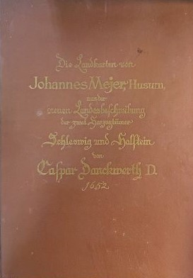
Die Landkarten des Johannes Mejer, Husum, aus der neuen Landesbeschreibung der zwei Herzogt�mer Schleswig und Holstein von Caspar Danckwerth D. 1652. Mit einer Einleitung von Christian Degn neu herausgegeben von K. Domeier und M. Haack. Faksimile der 40 Karten (innerhalb der Karten mit 35 Stadtpl�nen), des ill. Titels, der Widmung und des Inhaltsverzeichnisses der 1652 in Husum erschienenen Originalausgabe.
Published by Verlag Otto Heinevetter, Hamburg-Bergedorf, 1963
Seller: AixLibris Antiquariat Klaus Schymiczek, Aachen, Germany
Association Member: BOEV
Seller rating 5 out of 5 stars

Folio (42,6 x 33 cm). Erste Auflage, 5 Bl�tter, 85 Faksimile-Bl�tter. OPergaminband (Pergament imitierender Pappband) mit goldgepr. R�cken- und Deckeltitel. Mit faksimiliertem, ill. Titel, 40 doppeblattgro�en, faksimilierten Karten nach Kupferstichen und 8 faksimilierten Textseiten. Einband gering berieben und im Bereich des R�ckens leicht angestaubt; Kapitale leicht besto�en und mit winzigen Bezugsl�suren. Druck auf Hahnem�hle-B�tten (beschnitten).
-
Schleswig-Holstein 1652. Die Landkarten von Johannes Mejer, Husum, aus der neuen Landesbeschreibung der zwei Herzogt�mer Schleswig und Holstein von Caspar Danckwerth D. 1652.
Published by Hamburg-Bergedorf: Verlag Otto Heinevetter
Seller: Wonder Book, Frederick, MD, U.S.A.
Seller rating 5 out of 5 stars
Condition: Good. Hamburg-Bergedorf: Verlag Otto Heinevetter, 1982. Folio. Brown hardcover with gilt lettering on the front cover, gilt top-edge. Facsimile of the 1652 publication. 40 full page maps. German edition. Near Very Good condition. Cover lightly scratched and soiled. The front and rear free endpapers have a large fold, the front also showing light foxing. There is a short gifter's inscription to the front pastedown. Otherwise Very Good with light curling to a few lower corners. The title in English is "Schleswig-Holstein 1652. The maps by Johannes Mejer, Husum, from the new description of the two duchies of Schleswig and Holstein by Caspar Danckwerth D. 1652." (books in German, maps, cartography) Inquire if you need further information. NOT AVAILABLE FOR SHIPMENT OUTSIDE OF THE UNITED STATES.
-
Newe Landesbeschreibung der zwey Hertzogth�mer Schleswich und Holstein, zusambt vielen dabey geh�rigen Newen Landkarten. . Durch Casparum Danckwerth D. zusammengetragen und verfertigt. Worin auch das alte Teutschland k�rtzlich beschrieben .
Published by o.O. (Mathias et Nicolaus Petersen) (= Erste Ausgabe), 1652
First Edition
1. Auflage. 2�, Originalpergament in modernem Schuber (Hardcover) 301 S. + 46 S. Register, 40 doppelseitige Kupfer und Kupferkarten LiEFErUNG ALS DHL-BRIEFSENDUNG/PAKET IN PLASTIKFREIER VERPACKUNG - teilweise stockfleckig und papierbedingt gebr�unt, 1982 fachgerecht restauriert . (lt. montierter Empfangsbest�tigung von Egon K�mpen - Restaurator).
-
Newe Landesbeschreibung Der Zwey Hertzogth�mer Schleswich und Holstein, zusambt vielen dabeij geh�rigen Newen Landkarten, Die auff Ihr K�nigl. Majestett zu Dennemarck Norwegen etc. . von dero K�nigl. Maytt. bestaltem Mathematico Iohanne Mejero. .
Published by Matthias et Nicolaus Petersen, Husum, 1652
Seller: Antiquariat Friederichsen e. K., Hamburg, Germany
Association Member: BOEV
Seller rating 5 out of 5 stars
(.Chorographice elaborirt d�rch Casparum Danckwerth / Mit 1 (!) von 40 nicht-kolorierten Karten ). Das Titelblatt als Faksimile vorn eingebunden, 4 n.n. Bl�tter ( Dedication + Inhaltsverzeichnis ), 301 Seiten, 1 Blattt *Erratum cum notis*. Auf B�ttenpapier gedruckt. Mit einer doppelblattgro�en Kupferstich-Karte *Eigentlicher Abri� des Schleistroms mit den darin belegten Heringzeunen*. ( die �brigen 39 Kupferstichkarten fehlen leider im vorliegenden Band ). Leinwandband neuerer Zeit, Folio ( 47,5 x 35 cm ). Der neuere schlichte Ganzleinenband ist gering berieben, gering fleckig. Das Titelblatt in Faksimiledruck von guter Erhaltung, die Vorsatzbl�tter sind neu. Die vorhandenen originalen Textseiten mit einigen gestochenen Vignetten und Genealogien. Die Textseiten durchgehend meist stark gebr�unt sowie meist stark braunfleckig, einige Seiten mit handschriftlichen Anmerkungen, Randnotizen oder Anstrichen von sehr alter Hand in Tinte. Der doppelblattgro�e Kupferstich mit allerlei Nebenkarten zu den Heringsz�unen. Das Doppelblatt mit sch�ner Titelkartusche und Datierung *1649* mit st�rkeren Randl�sionen, etwas fleckig sowie leicht wasserrandig im wei�en Au�enrand. ( Bitte beachten: Hier leider nur 1 Kupferstich von urspr�nglich 40 Kupferstichen enthalten, alle Textseiten bis auf das Titelblatt sind vorhanden ). - selten - ( Gewicht 3700 Gramm ) ( Lagerort SR - oben ) ( Bitte beachten: Export au�erhalb der EU nur auf Anfrage ) ( Weitere Bilder auf Anfrage ) / Artikel 24157 /// (.Chorographice elaborirt d�rch Casparum Danckwerth / With 1 (!) of 40 uncolored maps). The title page is bound in facsimile at the front, 4 unnamed leaves (dedication + table of contents), 301 pages, 1 leaf *Erratum cum notis*. Printed on laid paper. With a double-page copperplate map *Actual outline of the Schleistrom with the herring colonies documented therein*. (The other 39 copperplate maps are unfortunately missing from this volume). Recent cloth binding, folio (47.5 x 35 cm). The newer, plain cloth binding is slightly rubbed and slightly stained. The facsimile title page is in good condition, the endpapers are new. The original text pages remain with some engraved vignettes and genealogies. The text pages are mostly heavily browned and mostly heavily brown-stained, some pages with handwritten annotations, marginal notes, or touches in very old ink. The double-page copperplate engraving features various inset maps of the herring fences. The double page with a beautiful title cartouche and the date *1649* has severe marginal damage, some staining, and slight waterstaining in the white outer margin. (Please note: Unfortunately, only one of the original 40 copperplate engravings is included here; all text pages except the title page are present.) - rare - (Weight 3700 grams) (Storage location SR - top) (Please note: Export outside the EU only upon request) (Further images upon request) / Item 24157.
-
![Seller image for Helgoland einst und jetzt 1891 [LeatherBound] for sale by True World of Books](https://pictures.abebooks.com/inventory/md/md31618007027.jpg)
Helgoland einst und jetzt 1891 [LeatherBound]
Publication Date: 2025
LeatherBound. Condition: New. BOOKS ARE EXEMPT FROM IMPORT DUTIES AND TARIFFS; NO EXTRA CHARGES APPLY. LeatherBound edition. Condition: New. Reprinted from 1891 edition. Leather Binding on Spine and Corners with Golden leaf printing on spine. Bound in genuine leather with Satin ribbon page markers and Spine with raised gilt bands. A perfect gift for your loved ones. Pages: 25 NO changes have been made to the original text. This is NOT a retyped or an ocr'd reprint. Illustrations, Index, if any, are included in black and white. Each page is checked manually before printing. As this print on demand book is reprinted from a very old book, there could be some missing or flawed pages, but we always try to make the book as complete as possible. Fold-outs, if any, are not part of the book. If the original book was published in multiple volumes then this reprint is of only one volume, not the whole set. Sewing binding for longer life, where the book block is actually sewn (smythe sewn/section sewn) with thread before binding which results in a more durable type of binding. Pages: 25.
-
![Seller image for Helgoland einst und jetzt. Bericht von Caspar Danckwerth vor ungefahr 250 Jahren uber die Insel geschrieben, neu. hrsg. mit Vorwort und Anmerkungen, sowie mit einer Bibliographie uber Helgoland versehen, von Max Harrwitz. 1891 [LeatherBound] for sale by S N Books World](https://pictures.abebooks.com/inventory/md/md31376335990.jpg)
LeatherBound. Condition: New. BOOKS ARE EXEMPT FROM IMPORT DUTIES AND TARIFFS; NO EXTRA CHARGES APPLY. Leather Binding on Spine and Corners with Golden leaf printing on spine. Bound in genuine leather with Satin ribbon page markers and Spine with raised gilt bands. A perfect gift for your loved ones. Reprinted from 1891 edition. NO changes have been made to the original text. This is NOT a retyped or an ocr'd reprint. Illustrations, Index, if any, are included in black and white. Each page is checked manually before printing. As this print on demand book is reprinted from a very old book, there could be some missing or flawed pages, but we always try to make the book as complete as possible. Fold-outs, if any, are not part of the book. If the original book was published in multiple volumes then this reprint is of only one volume, not the whole set and contains approximately 28 pages. IF YOU WISH TO ORDER PARTICULAR VOLUME OR ALL THE VOLUMES YOU CAN CONTACT US. Resized as per current standards. Sewing binding for longer life, where the book block is actually sewn (smythe sewn/section sewn) with thread before binding which results in a more durable type of binding. Language: German.
-
![Seller image for Helgoland einst und jetzt. Bericht von Caspar Danckwerth vor ungefahr 250 Jahren uber die Insel geschrieben, neu. hrsg. mit Vorwort und Anmerkungen, sowie mit einer Bibliographie uber Helgoland versehen, von Max Harrwitz. 1891 [LeatherBound] for sale by S N Books World](https://pictures.abebooks.com/inventory/md/md30877327418.jpg)
LeatherBound. Condition: NEW. BOOKS ARE EXEMPT FROM IMPORT DUTIES AND TARIFFS; NO EXTRA CHARGES APPLY. Leather Binding on Spine and Corners with Golden leaf printing on spine. Bound in genuine leather with Satin ribbon page markers and Spine with raised gilt bands. A perfect gift for your loved ones. Reprinted from 1891 edition. NO changes have been made to the original text. This is NOT a retyped or an ocr'd reprint. Illustrations, Index, if any, are included in black and white. Each page is checked manually before printing. As this print on demand book is reprinted from a very old book, there could be some missing or flawed pages, but we always try to make the book as complete as possible. Fold-outs, if any, are not part of the book. If the original book was published in multiple volumes then this reprint is of only one volume, not the whole set and contains approximately 32 pages. IF YOU WISH TO ORDER PARTICULAR VOLUME OR ALL THE VOLUMES YOU CAN CONTACT US. Resized as per current standards. Sewing binding for longer life, where the book block is actually sewn (smythe sewn/section sewn) with thread before binding which results in a more durable type of binding. Language: German.
-

Orbis vetus cum origine magnarum in eo gentium a filiis et nepotibus Noe
Published by Husum, 1651
Seller: Libreria Ex Libris ALAI-ILAB/LILA member, Roma, RM, Italy
Seller rating 5 out of 5 stars
Map
Carta geografica originale (cm. 53x43,5 pi� margini bianchi) tratta dall'opera 'Newe Landesbeschreibung der zweij Hertzogthumer Schleswig und Holstein'. Antichi restauri e rinforzi marginali, qualche altra lieve imperfezione. Bella coloritura d'epoca all'acquarello. Esemplare nel complesso in buono stato di conservazione.Rara mappa del Mondo antico tratta da un atlante dedicato alla provincia tedesca dello Schleswig-Holstein, pubblicato in collaborazione con Johann Meyer nel 1652. Christian Rothgiesser incise questa splendida carta entro una ricca bordura di cherubini, frutta, ghirlande, e scene di giardini. Quattro cartigli riempiono gli angoli della mappa; i due inferiori elencano i discendenti di No�. La carta indica i continenti con i classici nomi di Jafet, Sem e Cam, i figli di No�. Un'enorme 'Terra Australis Veteribus Prorsus Incognita' appare nella parte meridionale dell'emisfero, mentre il Polo Nord ha la forma di quattro isole principali e di numerose isole minori, come illustrato da Mercatore. Il continente asiatico � nettamente troncato, con il Giappone a forma di 'aquilone' e l'Isola di Corea. L'Africa � raffigurata in stile tolemaico. L'interno � privo di toponimi e caratterizzato solo da importanti caratteristiche topografiche. Cfr. Shirley, 'The mapping of the world', n. 388.
-

Newe Landesbeschreibung der zwei Herzogth�mer Schleswig und Holstein, zusambt vielen dabeij geh�rigen Newen Landkarten, die auff Ihr K�nigl. Maijist. Zu Dennemarck, Norwegen und Ihr F�rstl. Durchl. Beeder Regirenden Hertzogen zu Schleswich, Holstein etc.
Seller: Vangsgaards Antikvariat Aps, Copenhagen, Denmark
Seller rating 5 out of 5 stars
Schleswig/Slesvig 1652. Folio (45 x 30 cm). (8)+301+(3) pages. Engraved title + 40 double-pages with engraved maps and town plans. Contemporary full binding of marbled calf with richly gilt spine. Old ink stamp (Odense Kathedral-Skoles Bibliothek) on titlepage. The titlepage slightly frayed along lower edge. Slight foxing thorughout. Some maps with discreetly closed marginal tears (only visible on verso). The map with the northern part of Dithmarschen loosened. Table-of-contents in old hand on back flyleaf. * Graesse II,324. Bibl. Dan. III,653. An attractive copy of this outstanding atlas of the two duchies of Schleswig and Holstein, the present Danish province of S�nderjylland and the German "Bundesland" Schleswig-Holstein. The map material includes a map of "the old World" (Europe, Asia, Africa), a map of Germany and one of Scandinavia. Among the town plans is a magnificent city plan of Hamburg. The maps were engraved by the brothers Matthias and Nicolai Petersen, both of them goldsmiths in the town of Husum, after drawings by the highly talented cartographer Johannes Mejer (1606-74) who was also a citizen of Husum. Mejer got famous for his cartographic genius, and the plates for the Schleswig-Holstein atlas were bought by Willem Blaeu jun. and reused in coloured versions in his Atlas Maior, Amsterdam 1662. The Danckwerth atlas was the only work of Mejer to appear in print the cartographer's lifetime. A monumental atlas of Denmark was never fulfilled due to the disastrous wars between Denmark and Sweden 1657-60. ** The duchy of Schlesvig (Slesvig/S�nderjylland) was a part of Denmark, whereas the duchy of Holsten/Holstein sorted under the the German Empire, with the Kaiser in Vienna as sovereign. From 1460, the duchies were administered as an entity under the Danish king. In the 1650s, the area of Schleswig and Holstein was split (and had been since 1542) into regions either ruled by the Danish king or by his kinsman, the duke of Schleswig-Holstein-Gottorp. The Danckwerth atlas is a result of a united sponsporship of the Danish king Frederik III and his political counterpart, duke Friedrich III of Holstein-Gottorp. The latter used all his political energy to loosen his dukedom from the Danish realm by nurturing close relations to Sweden. However, both king and duke got their portraits - side by side - on the titlepage of this atlas. Thanks to this coordinated initiative, this great atlas appeared, giving a most detailed and accurate description of the area between the Baltic and the North Sea at a cartographic level far ahead of the time.*** The maps give an important documentation of the development of the coastline along the North Sea. A flood in 1634 changed it totally, swallowing both islands and towns, but Mejer has been able to produce credible maps of the area both before and after this disaster. The cartouches show all kinds of peasants, fishermen and town people, fullfilling the aspirations of this atlas to give at total description of this part of Europe as it was in the year of 1652. Mejer himself appears - shown at work - on one of the plates.
-

'ORBIS VETUS CUM ORIGINE MAGNARUM IN EO GENTIUM A FILIIS ET NEPOTIBUS NOE'. Classical representation of the Eastern Hemisphere, naming the continents of Japheth, Schem and Cham. Border of cherubs, fruits, garlands, and garden scenes. Two cartouches in lower corners listing the descendants of Noah. Engraved by
Published by Christian Rothgiesser for Caspar Danckwerth and Johann Meyer's 'Newe Landesbeschreibung der zweij Hertzogth�mer Schleswig und Holstein.' of 1651, 1651
Map
US$ 829.00
US$ 40.24 shipping
Ships from United Kingdom to U.S.A.Quantity: 1 available
Add to basket43x53cm. Full recent colour. Very good condition. Shirley/Mapping of the World 388 (= "Scarce").
-

Insull Arroe Kupferstich Geometrischer Grundriss Uon der Insull Arroe
Language: German
Published by ohne Verlagsangabe um 1650., 1650
Art / Print / Poster
Condition: Gut. Auflage ohne Angabe. 1 Blatt sch�ner seltener Kupferstich, hinter Passepartout guter Zustand. Sprache: Deutsch Gewicht in Gramm: 1100 Bildformat 29 x 18,5 - Gesamtformat 40 x 32 cm mit Passapartout.
-
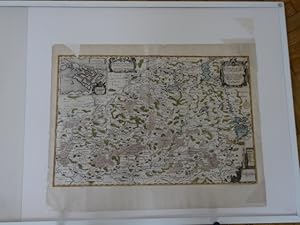
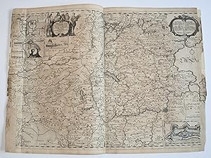
Landtkarte von den �mtern Rendsburg, Kiel und Bordesholm. Kolor. Kupferstichkarte v. J. Mejer bei Danckwerth, 1652.
Language: German
Published by ohne Verlagsangabe um 1652., 1652
Art / Print / Poster
Kartenma� 67 x 52,5 cm. Condition: Gut. Auflage ohne Angabe. 1 Blatt Kupferstich altkoloriert, guter Zustand,oben links Einriss in der Karte restauriert, der Teil fehlt, siehe Foto.Lieferung erfolgt in Kartenrolle. Sprache: Deutsch Gewicht in Gramm: 1100.
-
Newe Landesbeschreibung der zwey Hertzogth�mer Schleswich und Holstein, zusambt vielen dabey geh�rigen Newen Landkarten. (Schleswig), M. u. N. Petersen, 1652). Mit 40 doppelblattgro�en Kupferkarten. Folio. Schlichter Halblederband d. Zt. (st�rker beschabt u. besto�en, oberes Kapital mit Fehlstelle).
Language: German
Publication Date: 1652
Seller: Antiquariat Daniel Schramm e.K., Kiel, Germany
Seller rating 4 out of 5 stars

Condition: 0. Bruun III, 653.- Die sch�nen Gebietskarten meist nach Joh. Mejer von den Husumer Goldschmieden M. und N. Petersen gestochen. Desweiteren mit Bl�ttern mit je mehreren Detailkarten, darunter Itzehoe, Fehmarn, D�nisch Wohld u.a. Unter den gro�en Karten die Gesamtkarte mit 18 Randpl�nen, der Vogelschauplan von Hamburg, die Heringsfangkarte der Schlei und die sch�ne Weltkarte.- Ohne den Kupfertitel und ohne den Text.- Vereinzelt leicht fleckig, teils schwach feuchtrandig (meist nur im wei�en Au�ensteg).- Teilweise anger�ndert, drei Karten aufgezogen, vereinzelt etwas knapprandig, der Hamburg-Plan und 'Germania Antiqua' im Falz durchtrennt.- Stellenweise mit kleinen (Falz-)Einrissen, die beiden Dithmarschen-Karten (Sudertheill und Nordertheill) mit einigen kleinen hinterlegten Fehlstellen.- Danckwerth, C. Newe Landesbeschreibung der zwey Hertzogth�mer Schleswich und Holstein, zusambt viele dabey geh�rigen Newen Landkarten. (Schleswig), M. u. N. Petersen, 1652). With 40 double-page copper maps. Folio. Plain half leather d. Zt. (heavily rubbed and bumped, upper cape with missing part). Bruun III, 653 - The fine regional maps mostly engraved after Joh. Mejer by the Husum goldsmiths M. and N. Petersen. Also with sheets with several detailed maps each, including Itzehoe, Fehmarn, D�nisch Wohld, etc. Among the large maps the general map with 18 marginal plans, the bird show plan of Hamburg, the herring fishing map of the Schlei and the beautiful world map - without the copper title and without the text. Occasionally slightly stained, partly with faint dampstaining (mostly only in the white outer margin).- Partially edge-marked, three maps mounted, occasionally with slightly tight margins, the Hamburg map and 'Germania Antiqua' separated in the fold.- With small (fold) tears in places, the two Dithmarschen maps (Sudertheill and Nordertheill) with a few small backed losses. Sprache: Deutsch Gewicht in Gramm: 500.
-
Landtcarte Vom Ampte Apenrade und Luntoft herde.
Publication Date: 1652
Seller: Antiquariat Diderot, Kiel, SH, Germany
Seller rating 5 out of 5 stars
Original-Kupferstichkarte von Christian Rodtgie�er nach Johannes Mejer, Husum, aus: Caspar Danckwerth, "Newe Landesbeschreibung Der Zwey Hertzogth�mer Schleswich und Holstein", 1652. Ca.44 x 58 cm.- Seitenstege mit deutlichen Fehlstellen (Bildverlust!), teils hinterlegt, stellenweise schwach braunfleckig. Mittelfalz am Fu�steg auf ca. 8 cm eingerissen.- Mit mehreren dekorativen Kartuschen, Meilenzeiger, kleiner Legende und einem Inset Plan "Grundtriss der stat Apenrade mit dem schlo� Brundlundt" (inkomplett).- Zeigt die Ostseek�stenregion vom Genner Fjord mit Bars� �ber die Apenrader F�rde bis zur Eckernf�rder Bucht und Ahretoft. Graphik und Bilder, Landkarten, Kartographie, 17. Jahrhundert, Kupferstiche, Deutschland, Atlanten, Danckwerth-Atlas, Schleswig-Holstein, D�nemark, Aabenraa, S�dj�tland, Syddanmark.
-
Landtcarte Von Eyderstede Everschop Und Uthholm.
Publication Date: 1652
Seller: Antiquariat Diderot, Kiel, SH, Germany
Seller rating 5 out of 5 stars
Original-Kupferstichkarte von Matthias und Nicolaus Peters nach Johannes Mejer, Husum, aus: Caspar Danckwerth, "Newe Landesbeschreibung Der Zwey Hertzogth�mer Schleswich und Holstein", 1652. Ca. 42 x 58 cm.- Seitenstege mit deutlichen Fehlstellen (Bildverlust!, die meist geklappten, ca. 4 cm breiten Seitenteile fehlen vollst�ndig), teils hinterlegt, stellenweise schwach braunfleckig oder mit leichtem Abklatsch. Mittelfalz am Fu�steg auf ca. 15 cm eingerissen und hinterlegt.- Mit gro�er, fig�rlicher Titelkartusche, Meilenzeiger, kleiner Kompassrose und etwas Schiffsstaffage.- Zeigt die Nordseek�ste ab Nordstrand und S�dfall mit dem Wattenmeertief der Hever bis Husum, sowie ganz Eiderstedt mit Everschop und Udholm bis zur Eider. Graphik und Bilder, Landkarten, Kartographie, 17. Jahrhundert, Kupferstiche, Deutschland, Atlanten, Danckwerth-Atlas, Schleswig-Holstein, Eiderstedt, Nordfriesland.
-
Landtcarte Vom S�derntheil des Wagerland's Und ein theil 'Stormaria', Worinnen da� Stifft Lubeck, das F�rstenthumb Pl�en Und das Ambt Segeberg begriffen. Anno 1650.
Publication Date: 1652
Seller: Antiquariat Diderot, Kiel, SH, Germany
Seller rating 5 out of 5 stars
Original-Kupferstichkarte von Johannes Mejer, Husum, aus: Caspar Danckwerth, "Newe Landesbeschreibung Der Zwey Hertzogth�mer Schleswich und Holstein", 1652. Ca. 44 x 60 cm.- Karte in den Seitenstegen fragmentarisch - es fehlen (meist knappe) Teile der Darstellung - und st�rker gebr�unt. Falz im unteren Viertel angeplatzt und ebenso wie die Seitenstege hinterlegt. Blatt teils etwas gebr�unt.- Zeigt den s�dlichen Teil Wagriens mit dem Wardersee etwa im Zentrum, dar�ber der Pl�ner See. Im unteren Bereich der damalige Verlauf der Trave �ber Oldesloe und L�beck bis Travem�nde.- Mit fig�rlich eingefasster Titelkartusche links, ornamental gefasster Dedikationskartusche oben rechts, kleiner Kompassrose im Bereich der Ostsee, Meilenzeiger und umlaufender Gradskala.- Mit vier Inset-Pl�nen: unten links "Grundri� Tra�em�nde" (der rechte Abschlussfehlt hier), oben links "Grundtri� der stadt Und d. Schlo� Eutyn ao. 1648", Grundris der stadt & schlo� segeberg ao. 1648", sowie eine Ansicht von "Segeberg" mit "Ieschnhagn". Graphik und Bilder, Landkarten, Kartographie, 17. Jahrhundert, Kupferstiche, Deutschland, Atlanten, Danckwerth-Atlas, Schleswig-Holstein, Wagrien, Holstein, Ostholstein, Pl�n, L�beck, Bad Segeberg, Travem�nde, Eutin, Stormarn, Bad Oldesloe.
-

Kein Einband. Condition: Gut. Bad Oldesloe, anno 1651, Kupferstich, altkoloriert, Danckwerth-Mejer Oldesloe.- Grundtri� der Statt Oldesloh. Anno 1641. Grundtri� der Statt Oldesloh. Anno 1641. Altkolorierter Kupferstichplan von J. Mejer aus Danckwerth, 1651. 18 x 28,5 cm.
-

Itzehoe, anno 1652, Grundriss aus Mejer Husum/Danckwerth, altkoloriert Darstellung: 17x27 cm.
Publication Date: 1652
Art / Print / Poster
Kein Einband. Condition: Gut. Itzehoe, anno 1652, Grundriss aus Mejer Husum/Danckwerth, altkoloriert Darstellung: 17x27 cm.
-
Landtcarte Von Nordgoesherde Ambt Husum Lundenberg Vndt dem Nortstrande.
Publication Date: 1652
Seller: Antiquariat Diderot, Kiel, SH, Germany
Seller rating 5 out of 5 stars
Original-Kupferstichkarte von Johannes Mejer, Husum, aus: Caspar Danckwerth, "Newe Landesbeschreibung Der Zwey Hertzogth�mer Schleswich und Holstein", 1652. Ca. 44,5 x 59 cm.- Zeigt den K�stenverlauf und die Inseln von Dageb�ll bis Eiderstedt.- Mit Titel- und Textkartusche, Gradskala, Meilenzeiger und kleiner Kompassrose.- R�nder knapp beschnitten und mit einigen Einrissen und Fehlstellen (in der unteren H�lfte des rechten Seitensteges fehlen ca. 2 cm der Darstellung). Mittelfalz stellenweise hinterlegt, stellenweise etwas gebr�unt, oben leicht fleckig. Eintrag von alter Hand (braune Tinte) in der Bredstedter Bucht: "Soph. Magd. Koeg" (Sophien-Magdalenen-Koog). Graphik und Bilder, Landkarten, Kartographie, 17. Jahrhundert, Kupferstiche, Deutschland, Atlanten, Danckwerth-Atlas, Schleswig-Holstein, Nordfriesland, Inseln, Insel Strand, Nordstrand, Beltringharde, Pellworm, Edomsharde, Heuerstrom, Wattenmeer, Nordsee, Sturmfluten, Bredstedt, Husum, Halligen, Hallig Hooge, Gr�de, Langene�, S�deroog, S�dfall, Goesharde, Hattstedtermarsch, Lundenberg.
-
Westertheil des Amptes Haderschleben Zusambt Riepen Und dem L�hmcloster. Anno 1648.
Publication Date: 1652
Seller: Antiquariat Diderot, Kiel, SH, Germany
Seller rating 5 out of 5 stars
Original-Kupferstichkarte von Matthias und Clau� Petersen nach Johannes Mejer, Husum, aus: Caspar Danckwerth, "Newe Landesbeschreibung Der Zwey Hertzogth�mer Schleswich und Holstein", 1652. Ca. 44 x 58 cm.- Zeigt den Nordseek�stenverlauf und die Inseln vom S�dteil der Insel Fan� �ber Mand� und R�m bis zum Nordteil der Insel Sylt sowie das Festland von Ribe bis Tondern.- Mit umlaufender Gradskala, zwei gro�en Kartuschen samt Meilenzeiger, Legende, kleiner Kompassrose und etwas Schiffsstaffage.- Fu�steg knapp und mit kleinen Fehlstellen au�erhalb der Darstellung, wei�e Seitenstege stellenweise gebr�unt oder feuchtrandig sowie stellenweise hinterlegt, rechter Seitensteg mit ca. 5 cm Fehlstelle am unteren Rand (kein Bildverlust). Mittelsteg unten eingerissen und auf ca. 6,5 cm hinterlegt. Graphik und Bilder, Landkarten, Kartographie, 17. Jahrhundert, Kupferstiche, Deutschland, Atlanten, Danckwerth-Atlas, Schleswig-Holstein, D�nemark, J�tland, S�dj�tland, Hadersleben, Nordsee, Wattenmeer, Inseln, Fan�, R�m�, Mand�, Sylt, L�gumkloster, T�nder, Ribe.
-
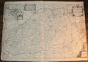
Landtcarte Von den Ambtern Rendsborg, Kiel und Bordesholm. Anno 1649.
Publication Date: 1652
Seller: Antiquariat Diderot, Kiel, SH, Germany
Seller rating 5 out of 5 stars
Original-Kupferstichkarte von Christian Lorenz Rothgie�er nach Johannes Mejer, Husum, aus: Caspar Danckwerth, "Newe Landesbeschreibung Der Zwey Hertzogth�mer Schleswich und Holstein", 1652. Ca. 45 x 61 cm.- In den Seitenstegen Randl�sionen, Br�unungen und etliche kleine Fehlstellen. Mittelfalz und Seitenstege komplett hinterlegt.- Zeigt das Gebiet von Rendsburg und Kiel im Norden bis Itzehoe, Kellinghusen und Segeberg im S�den (West-Ost-Ausdehnung etwas von Wilster bis Pl�n).- Mit ornamental eingefasster Titelkartusche und Dedikationskartsuche (lateinisch), kleiner Legenden-Kartusche mit fig�rlich staffiertem Meilenzeiger unte rechts, umlaufender Gradskala und einem Inset-Plan oben links "Grundtriss der Stadt und des Schlosses Rendsburg. Anno 1649" (ca. 12 x 14 cm). Graphik und Bilder, Landkarten, Kartographie, 17. Jahrhundert, Kupferstiche, Deutschland, Atlanten, Danckwerth-Atlas, Schleswig-Holstein, Rendsburg, Kiel, Bordesholm.
-
Germania Antiqua Australis.
Publication Date: 1652
Seller: Antiquariat Diderot, Kiel, SH, Germany
Seller rating 5 out of 5 stars
Altkolorierte Kupferstichkarte von Christian Rothgie�er nach Johannes Mejer, Husum, aus: Caspar Danckwerth, "Newe Landesbeschreibung Der Zwey Hertzogth�mer Schleswich und Holstein", 1652. Ca. 42 x 58 cm.- "Cum Contermina Galliae parte et Rhaetia, Dindeliciaque Nonico et Pannonia" (Untertitel).- Mit umlaufendem Meilenzeiger. Titelkartusche, fig�rliche Kartusche unten links, sowie die Beschriftung lateinisch.- Karte leicht gebr�unt, , verso st�rker, minimale L�sionen im wei�en Au�ensteg, Mittelfalz unten angeplatzt.- Zeigt unter anderem die Ausbreitung der (vornehmlich germanischen) alten Volksst�mme, wie Sachsen, Langobarden, Vandalen, Cherusker, Goten, Helveten, Burgunden, Alemannen u.v.m. Graphik und Bilder, Geographie, Deutschland, Germania, Germanien, germanische Volksst�mme, Bev�lkerungsgruppen, Landkarten, Kartographie, 17. Jahrhundert.
-
Landtcarte Vom Ostertheile des Ambtes Hatersleben. Genandt Baringsyssell.
Publication Date: 1652
Seller: Antiquariat Diderot, Kiel, SH, Germany
Seller rating 5 out of 5 stars
Original-Kupferstichkarte von Matthias und Clau� Petersen nach Johannes Mejer, Husum, aus: Caspar Danckwerth, "Newe Landesbeschreibung Der Zwey Hertzogth�mer Schleswich und Holstein", 1652. Ca. 44 x 58 cm.- Einige Braunflecken und stellenweise schwachbrauner Abklatsch, verso gr��erer Tintenfleck (ohne Durchschlag), im wei�en Kopfsteg mittig gering gebr�unt. Insgesamt gut erhalten.- Zeigt den Ostteil von S�dj�tland mit der K�stenlinie der Ostsee vom Koldingfjord �ber die Haderslebener F�rde bis Bars�.- Mit Titelkartusche mit leerer Wappenkartusche oben links, Dedikationskartusche (Latein) unten links, kleiner Legendenkartusche unten rechts, Meilenzeiger, Kompassrose und etwas Schiffsstaffage.- Graphik und Bilder, Landkarten, Kartographie, 17. Jahrhundert, Kupferstiche, Deutschland, Atlanten, Danckwerth-Atlas, Schleswig-Holstein, D�nemark, Hadersleben, Ostsee, Syddanmark, Baringsyssel, Kolding.
-
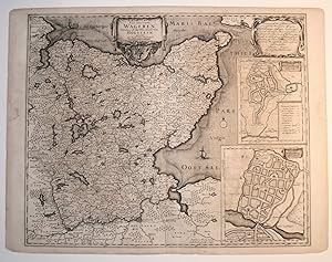
Landtcarte Von dem Lande Wageren. Welches ist das Ostertheil Von Holstein. ao. 1651.
Publication Date: 1652
Seller: Antiquariat Diderot, Kiel, SH, Germany
Seller rating 5 out of 5 stars
Original-Kupferstichkarte von Matthias und Nicolas Peters nach Johannes Mejer, Husum, aus: Caspar Danckwerth, "Newe Landesbeschreibung Der Zwey Hertzogth�mer Schleswich und Holstein", 1652. Ca. 44 x 57 cm.- Stellenweise leicht bis st�rker gebr�unt, kleine schwache Feuchtr�nder in den wei�en Seitenstegen (je ca. 4 x 3 cm).- Zeigt die komplette Halbinsel Wagrien, mittig das Gebiet der Holsteinischen Schweiz mit Pl�n und Pl�ner See, im S�den der damalige Lauf der Trave von Bad Oldesloe bis Travem�nde. Im Norden und Osten der damalige Verlauf der Ostseek�ste von der Kieler F�rde �ber den Fehmarn Sund bis zur L�becker Bucht.- Rechts zwei Inset-Pl�ne der Stadt Oldenburg, der obere "Grundtri� Oldenburg. ano. 1651" (mit Legende) 16 x 13 cm, der untere "Grundtri� Oldenburg. Anno 1320" 18 x 16 cm.- Mit ornamental eingefasster Titelkartusche mit Meilenzeiger und Wappen, Dedikationskartusche oben rechts (lateinisch), umlaufender Gradskala, kleiner Kompassrose und dekorativer Schiffsstaffage. Graphik und Bilder, Landkarten, Kartographie, 17. Jahrhundert, Kupferstiche, Deutschland, Atlanten, Danckwerth-Atlas, Schleswig-Holstein, Wagrien, Holstein, Ostholstien, Pl�n, Holsteinische Schweiz, Oldenburg, Kiel, Hansestadt L�beck, Ostsee.
-
Sndertheil (!) Uom Alt Nord Frie�lande bi� an das Jahr 1240.
Publication Date: 1652
Seller: Antiquariat Diderot, Kiel, SH, Germany
Seller rating 5 out of 5 stars
Original-Kupferstichkarte von Johannes Mejer, Husum, aus: Caspar Danckwerth, "Newe Landesbeschreibung Der Zwey Hertzogth�mer Schleswich und Holstein", 1652. Ca. 45 x 62,5 cm.- Bildet den S�dteil von Nordfriesland vor dem Jahr 1240 ab. Oben links eine gro�e Inset-Karte von Rungholt: "Abriss Uon Rungholte Und Seinen Kirchspielen Anno 1240".- Mit umlaufender Gradskala, Titelkartusche, gro�er fig�rlicher Textkartusche unten rechts, Meilenzeiger, kleiner Kompassrose und etwas Schiffsstaffage.- Seitenstege hinterlegt, sehr knapp beschnitten (links fehlt die Umrandung ganz), mit Einrissen und kleinen Fehlstellen sowie etwas angeschmutzt. Mittelfalz unten eingerissen und auf ca. 6 cm hinterlegt. Deutliche Quetschfalte in der Mitte der linken Kartenh�lfte. Graphik und Bilder, Landkarten, Kartographie, 17. Jahrhundert, Kupferstiche, Deutschland, Atlanten, Danckwerth-Atlas, Schleswig-Holstein, Nordfriesland, Inseln, Rungholt, Nordstrand, S�deroog, Utholm, Everschop, Eiderstedt, Eider, Heuerstrom, Wattenmeer, Nordsee, Sturmfluten.
-
Grundtri� der Stadt Undt des Schlo�es Kiell. Anno 1652. Grundtris der Stadt Rendsburg mit seinen bel�gerung und Wercken. Anno 1645. Grundtri� der Stadt Itzehoa. Anno 1651. Grundtri� der statt Oldesloh. Anno 1641.
Publication Date: 1652
Seller: Antiquariat Diderot, Kiel, SH, Germany
Seller rating 5 out of 5 stars
4 Pl�ne auf 1 Blatt. Original-Kupferstich von Matthias & Nicolas Peters nach Johannes Mejer, Husum, aus: Caspar Danckwerth, "Newe Landesbeschreibung Der Zwey Hertzogth�mer Schleswich und Holstein", 1652. Ca. 45 x 57 cm.- Seitenstege knapprandig, etwas gebr�unt, mit Randl�sionen und kleinen Fehlstellen (gr��ere Fehlstellen an den unteren Ecken). Kleine Braunflecken am Mittelfalz. Au�enstege, unterer Falz und blattmittig vertikal mit Papierstreifen alt hinterlegt. Blatt teils etwas gewellt, leichte Quetschfalte im Bereich des Itzehoe-Planes.- Jeder Stadtplan mit ornamental eingefasster Titelkartusche, Meilenzeiger, umlaufender Gradskala und Stadtwappen. Gro�e Dedikationskartusche im Plan von Itzehoe (lateinisch), in den �brigen drei Pl�nen fig�rliche und szenische Staffage, Rendsburg mit kleiner Kompassrose. Graphik und Bilder, Landkarten, Kartographie, 17. Jahrhundert, Kupferstiche, Deutschland, Atlanten, Danckwerth-Atlas, Schleswig-Holstein, Stadtpl�ne, Kiel, Rendsburg, Itzehoe, Kreis Steinburg, Bad Oldesloe, Kreis Stormarn, Wappen.
-
Newe Landesbeschreibung der zwey Hertzogth�mer Schleswich und Holstein, zusambt vielen dabey geh�rigen Newen Landcarten die von Johanne Mejero chorographice elaborirt, d�rch Casparus Dankwerth, zusammen getragen und verfertigt, worin auch das alte Teutsland k�rtzlich beschrieben, mit begriffen ist.
Seller: Ruuds Antikvariat, Oslo, Norway
Seller rating 5 out of 5 stars
Husum, Matthias et Nicolaus Petersen, 1652. Folio. (8) + 301 + (3) pp. Engraved title. 40 engraved double-paged maps, of which 2 partly hand-coloured. The maps were drawn by Johannes Mejer and engraved by Matthias and Nicolaus Petersen. Text by Caspar Danckwerth. Original decorated vellum. One corner skilfully restored. Three maps with marginal repairs. Some foxing as usual, but overall a clean and well preserved copy of the earliest printed Danish atlas. Provenence: Bertel Bartholin (1614-1690). Danish professor and son of Caspar Bartholin, inscription dated Haffni� 1666, and later Traugott M�ller?s collection. .
-
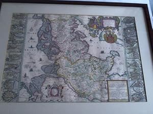
Newe Landtcarte von den beiden Hertzogth�mbern Schleswig und Holstein zusamen anno 1650. Karte im Kupferstich
Seller: Celler Versandantiquariat, Eicklingen, Germany
Association Member: GIAQ
Seller rating 5 out of 5 stars
Meyer, Husum, 1652. Karte im Kupferstich mit Grenz- und Fl�chenkolorit. mape 41,9 cm x 59,5 cm. Oben rechts gro�e Titel-Kartusche und Wappen. Am unteren Rand zwei weitere Kasrtuschen mit Widmungen und Erkl�rungen. Gezeogt werden die Herzogt�mer Schleswig und Holstein sowie am linken Rand 10 und am rechten Rand 8 Stadtgrundrisse. Unter Glas mit brauner Holzleiste gerahmt--- - sehr gutes Exemplar/Aufgezeigt werden die Stadtgrundrisse von Hamburg, Kiel, Rend�borg,Itzchoa, Oldesloh, Krempe, Gluckstadt, Pl�en, Rypen, Sleswieg, Fdlensborg, Haderschleben, Husum, Tondern, Sonderborg, Apenrade, Eckernf�rde, Tonning - 2310 Gramm.
-

(Herausgeber). Die Landkarten von Johannes Mejer, Husum, aus der neuen Landesbeschreibung der zwei Herzogt�mer Schleswig und Holstein von Caspar Danckwerth D. 1652. Mit einer Einleitung von Christian Degn. Hamburg, Heinevetter, 1963 (Nachdruck der Ausgabe Schleswig, 1652). 10 Bl�tter, 40 doppelblattgro�e Karten. Folio. Gr�ner goldgepr�gter Original-Pappband in Leinenoptik.
Language: German
Publication Date: 1963
Seller: Antiquariat Daniel Schramm e.K., Kiel, Germany
Seller rating 4 out of 5 stars
Condition: 0. Sprache: Deutsch Gewicht in Gramm: 500.