
Order Total (1 Item Items):
Shipping Destination:

Dheulland (41 results)
Author:
dheulland
Refine with Advanced Search
Skip to main search results
Search filters
Product Type
- All Product Types
- Books (23)
- Magazines & Periodicals (No further results match this refinement)
- Comics (No further results match this refinement)
- Sheet Music (No further results match this refinement)
- Art, Prints & Posters (6)
- Photographs (No further results match this refinement)
- Maps (12)
- Manuscripts & Paper Collectibles (No further results match this refinement)
Condition Learn more
- New (11)
- As New, Fine or Near Fine (6)
- Very Good or Good (8)
- Fair or Poor (No further results match this refinement)
- As Described (16)
Binding
Collectible Attributes
- First Edition (No further results match this refinement)
- Signed (No further results match this refinement)
- Dust Jacket (No further results match this refinement)
- Seller-Supplied Images (31)
- Not Print on Demand (36)
Language (2)
Free Shipping
Seller Location
Seller Rating
-

-

Th��tre de la derni�re guerre en Allemagne. 2e �dition (Paperback or Softback)
Language: French
Published by Hachette Livre - BNF 4/10/2022, 2022
ISBN 10: 2329750897 ISBN 13: 9782329750897
Paperback or Softback. Condition: New. Th��tre de la derni�re guerre en Allemagne. 2e �dition. Book.
-
Condition: As New. Unread book in perfect condition.
-
Th��tre de la derni�re guerre en Allemagne. 2e �dition (French Edition)
Seller: Ria Christie Collections, Uxbridge, United Kingdom
Seller rating 5 out of 5 stars

US$ 22.96
US$ 15.98 shipping
Ships from United Kingdom to U.S.A.Quantity: Over 20 available
Add to basketCondition: New. In.
-
Th��tre de la derni�re guerre en Allemagne. 2e �dition: Tome 1
Language: French
Published by HACHETTE LIVRE-BNF 2022-04-10, 2022
ISBN 10: 2329750897 ISBN 13: 9782329750897
US$ 18.97
US$ 20.66 shipping
Ships from United Kingdom to U.S.A.Quantity: Over 20 available
Add to basketPaperback. Condition: New.
-
Th��tre de la derni�re guerre en Allemagne. 2e �dition -Language: french
Seller: GreatBookPricesUK, Woodford Green, United Kingdom
Seller rating 5 out of 5 stars
US$ 22.39
US$ 20.01 shipping
Ships from United Kingdom to U.S.A.Quantity: Over 20 available
Add to basketCondition: New.
-
Th��tre de la derni�re guerre en Allemagne. 2e �dition -Language: french
Seller: GreatBookPricesUK, Woodford Green, United Kingdom
Seller rating 5 out of 5 stars
US$ 25.71
US$ 20.01 shipping
Ships from United Kingdom to U.S.A.Quantity: Over 20 available
Add to basketCondition: As New. Unread book in perfect condition.
-

Condition: New.
-
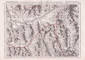
"Environs de Suse et de St. Jean de Morienne" - Susa Modane Saint-Jean-de-Maurienne Piemonte Italia Savoie Savoia Auvergine France Karte map
Language: French
Published by Paris, Dheulland, 1748
Seller: Antiquariat Steffen V�lkel GmbH, Seubersdorf, Germany
Seller rating 5 out of 5 stars
Map
Blattmasse: ca. 25,5 x 35,5 cm. - Seltene grenzkolorierte Kupferstich-Karte von 1748. -- gut erhalten. || Rare colored copper engraved map from 1748. in very good condition. // Wir, das Antiquariat Steffen V�lkel, kaufen und verkaufen alte B�cher, Handschriften, Zeichnungen, Autographen, Grafiken und Fotografien. Wir sind stets am Ankauf von kompletten Bibliotheken, Sammlungen und Nachl�ssen interessiert. Sprache: Franz�sisch Gewicht in Gramm: 20.
-

"Environs de Monstier et de Morges" - Morgex Bourg-Saint-Maurice Moutiers Aostatal Savoie Savoia Italy Italia Italien France Frankreich Karte map
Language: French
Published by Paris, Dheulland, 1748
Seller: Antiquariat Steffen V�lkel GmbH, Seubersdorf, Germany
Seller rating 5 out of 5 stars
Map
Blattmasse: ca. 25,5 x 35,5 cm. - Seltene grenzkolorierte Kupferstich-Karte von 1748. -- gut erhalten. || Rare colored copper engraved map from 1748. in very good condition. // Wir, das Antiquariat Steffen V�lkel, kaufen und verkaufen alte B�cher, Handschriften, Zeichnungen, Autographen, Grafiken und Fotografien. Wir sind stets am Ankauf von kompletten Bibliotheken, Sammlungen und Nachl�ssen interessiert. Sprache: Franz�sisch Gewicht in Gramm: 20.
-

Condition: Normal. Jombert. Paris 1737-1753, 36 x 25 cm (hueco de ventana) Fuente: ARCHITECTURE HYDRAULIQUE de Bernard Forest de Belidor. Passepartout biselado; optimo estado de conservacion general. HIDRAULICA . Ejemplares disponibles: 1 Normal.
-
PAP. Condition: New. New Book. Shipped from UK. THIS BOOK IS PRINTED ON DEMAND. Established seller since 2000.
-

"Environs de Genes, Savone et Finale" - Genova Savona Finale Ligure Liguria Italia Itlay Italien Karte map
Language: French
Published by Paris, Dheulland, 1748
Seller: Antiquariat Steffen V�lkel GmbH, Seubersdorf, Germany
Seller rating 5 out of 5 stars
Map
Blattmasse: ca. 25,5 x 35,5 cm. - Seltene grenzkolorierte Kupferstich-Karte von 1748. -- gut erhalten. || Rare colored copper engraved map from 1748. in very good condition. // Wir, das Antiquariat Steffen V�lkel, kaufen und verkaufen alte B�cher, Handschriften, Zeichnungen, Autographen, Grafiken und Fotografien. Wir sind stets am Ankauf von kompletten Bibliotheken, Sammlungen und Nachl�ssen interessiert. Sprache: Franz�sisch Gewicht in Gramm: 20.
-

Condition: Normal. Jombert. Paris 1737-1753, 36 x 25 cm (hueco de ventana) Fuente: ARCHITECTURE HYDRAULIQUE de Bernard Forest de Belidor. Passepartout biselado; optimo estado de conservacion general. HIDRAULICA . Ejemplares disponibles: 1 Normal.
-

Condition: Normal. Jombert. Paris 1737-1753, 37 x 25 cm (hueco de ventana) Fuente: ARCHITECTURE HYDRAULIQUE de Bernard Forest de Belidor. Passepartout biselado; optimo estado de conservacion general. HIDRAULICA . Ejemplares disponibles: 1 Normal.
-
Th??tre de la derni?re guerre en Allemagne. 2e ?dition
Seller: PBShop.store UK, Fairford, GLOS, United Kingdom
Seller rating 5 out of 5 stars
US$ 24.84
US$ 4.39 shipping
Ships from United Kingdom to U.S.A.Quantity: Over 20 available
Add to basketPAP. Condition: New. New Book. Delivered from our UK warehouse in 4 to 14 business days. THIS BOOK IS PRINTED ON DEMAND. Established seller since 2000.
-
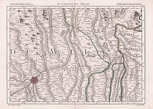
"Environs de Milan" - Milano Soncino Treviglio Lombardia Italy Italia Italien Karte map
Language: French
Published by Paris, Dheulland, 1748
Seller: Antiquariat Steffen V�lkel GmbH, Seubersdorf, Germany
Seller rating 5 out of 5 stars
Map
Blattmasse: ca. 25,5 x 35,5 cm. - Seltene grenzkolorierte Kupferstich-Karte von 1748. -- gut erhalten. || Rare colored copper engraved map from 1748. in very good condition. // Wir, das Antiquariat Steffen V�lkel, kaufen und verkaufen alte B�cher, Handschriften, Zeichnungen, Autographen, Grafiken und Fotografien. Wir sind stets am Ankauf von kompletten Bibliotheken, Sammlungen und Nachl�ssen interessiert. Sprache: Franz�sisch Gewicht in Gramm: 20.
-
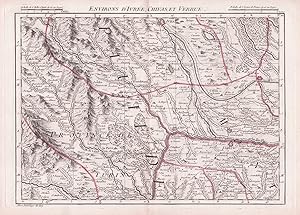
"Environs d'Ivree, Chivas et Verrue" - Ivrea Santhia Chivasso Crescentino Piemonte Italia Italy Italien Karte map
Language: French
Published by Paris, Dheulland, 1748
Seller: Antiquariat Steffen V�lkel GmbH, Seubersdorf, Germany
Seller rating 5 out of 5 stars
Map
Blattmasse: ca. 25,5 x 35,5 cm. - Seltene grenzkolorierte Kupferstich-Karte von 1748. -- gut erhalten. || Rare colored copper engraved map from 1748. in very good condition. // Wir, das Antiquariat Steffen V�lkel, kaufen und verkaufen alte B�cher, Handschriften, Zeichnungen, Autographen, Grafiken und Fotografien. Wir sind stets am Ankauf von kompletten Bibliotheken, Sammlungen und Nachl�ssen interessiert. Sprache: Franz�sisch Gewicht in Gramm: 20.
-
Carte Nouvelle du Duch� de Brabant et Partie de La Hollande
Language: French
Published by Dheulland, 1750
Seller: Morning Mist Books and Maps, Cirencester, United Kingdom
Seller rating 5 out of 5 stars
Map
US$ 343.52
US$ 60.03 shipping
Ships from United Kingdom to U.S.A.Quantity: 1 available
Add to basketHardcover. Condition: Very Good. Undated but estimated at around 1750 based on the publishing activities of Dheulland. Sub-title and the text adjacent to the summary map indicates it was produced for the French king to be used by the troops and officers on campaign, should they be in the aforementioned regions. The towns and cities are shown with fortifications, along with key routes. With this copy, the maps are presented as flat sheets in contrast to the more portable form where the maps are part folded. Modern rebind retaining part of the original spine. Marbled boards slightly scuffed to edges. Spine with damage to the upper compartment: split and lifting to the rear gutter. Binding firm. Marbled pastedowns and endpapers. Colour summary map with title adjacent: surface loss and hole, partly affecting title. 24 maps with part-colouring: slight spotting and minor marking. Each leaf with contemporary manuscript numbering different to the summary list (the first leaf is now numbered 1 and runs through to 25, whereas in the list, the summary leaf is unnumbered and the maps are 1-24). Sharp. clear printing. Book size: 28.5cm by 40.5cm by 1.5cm approx. Other that the summary page, there is no text. Printing one-sided. Further details available on request. (Ub7).
-

Plan de la ville de Paris au XVIe si�cle. Telle qu'elle �tait sous le r�gne de Charles IX. Grav� d'apr�s une tapisserie conserv�e dans l'H�tel de ville.
Language: French
Published by Taride, Paris
Seller: Librairie les mains dans les poches, Tourbes, France
Seller rating 5 out of 5 stars
Pas de couverture. Condition: Bon. Sans date (circa 1910). Dimensions de la feuille : 75x102 cm. Fac-simil� d'apr�s Dheulland, 1766. Pli�.
-

Plan des Attaques de la Ville de Lille. Planche n�47.
Published by ***
Map
Pas de couverture. Condition: bon. RO80092365: XIXe si�cle. In-4. En feuillets. Bon �tat, Couv. convenable, Dos satisfaisant, Int�rieur frais. Un plan grav� en noir et blanc, de 24.5 x 39 cm. A l'italienne. . . . Classification Dewey : 912-Atlas, cartes et plans.
-

Carte de la Cor�e. Dheulan sculp.
Language: French
Published by (1754)., 1754
Seller: Antiquariat An der Vikarie, Grafschaft-Leimersdorf, Germany
Association Member: GIAQ
Seller rating 5 out of 5 stars
Map
Papier etwas gebr�unt und schwach knickspurig, kleiner Randeinri� mit Papier hinterlegt, ansonsten gut erhalten, Lieferung einmal gefaltet / paper slightly browned and a bit creased, little tear at the margin, reinforced at the back side with paper strip, else good, shipment / delivery once folded, (Karte, old Map, Korea, Cor�e), Sprache: Franz�sisch Gewicht in Gramm: 100 Karte / map: ca. 16,3 x 28,6 cm. Blatt / sheet: ca. 19 x 32,3 cm.
-
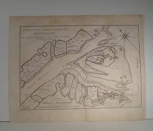
Carte des embouchures du Mississipi (Mississippi). Par N. Bellin Ing. de la Marine, tir� de : Histoire et Description g�n�rale de la Nouvelle-France., �dition Veuve Ganeau et Nyon, Paris, 1744
Publication Date: 1744
Seller: Librairie Bonheur d'occasion (LILA / ILAB), Montr�al, QC, Canada
Seller rating 5 out of 5 stars
Map
En feuille. Condition: Tr�s bon. Dheulland, sculptit (illustrator). 20 x 28 cm. Jacques-Nicolas Bellin (1703-1772), cartographe et hydrographe de la Marine de France, a dessin� un grand nombre de cartes de l'Am�rique du Nord. Cartes g�ographiques.
-

Plan du Bassin de Quebec et de Ses Environs
Publication Date: 1744
Seller: Attic Books (ABAC, ILAB), London, ON, Canada
Seller rating 5 out of 5 stars
Condition: Near fine. Approx. 22x31 cm copperplate engraving in 35x43 cm grey mat. On backerboard, wrapped in mylar. Hand coloured. N. B. is Jacques-Nicolas Bellin (1703-72), French hydrographer and geographer.
-

Plan de la Ville de Meaco
Published by Chez Didot, 1752]., [Paris,, 1752
Seller: Daniel Crouch Rare Books Ltd, London, United Kingdom
Association Member: ABA ILAB PBFA
Seller rating 4 out of 5 stars

Map
US$ 206.11
US$ 26.68 shipping
Ships from United Kingdom to U.S.A.Quantity: 1 available
Add to basketPlan of Kyoto Engraved plan. A plan of Kyoto (Meaco) from a later edition of the Abb� Pr�vost's travel book, the 'Histoire Generale des Voyages'. Pr�vost's work was an expansion of Thomas Astley's 'Voyages and Travels' compiled by Astley from sources including John Atkins, Theodor de Bry and Jean-Baptiste Lavat. The first seven volumes of Astley's work were translated into French by the Abb� Antoine Fran�ois Pr�vost (1697-1763). As well as translating Astley's work, Pr�vost added a general history of discoveries and colonisation to his own lifetime, as well as an overview of the historical sources he used. The maps and plans in Pr�vost's work were drawn by Jacques Nicolas Bellin, and engraved by Guillaume Dheulland.
-

Plan de la Ville de Meaco
Published by Chez Didot, 1752]., [Paris,, 1752
Seller: Daniel Crouch Rare Books Ltd, London, United Kingdom
Association Member: ABA ILAB PBFA
Seller rating 4 out of 5 stars
Map
US$ 206.11
US$ 26.68 shipping
Ships from United Kingdom to U.S.A.Quantity: 1 available
Add to basketPlan of Kyoto Engraved plan. A plan of Kyoto (Meaco) from a later edition of the Abb� Pr�vost's travel book, the 'Histoire Generale des Voyages'. Pr�vost's work was an expansion of Thomas Astley's 'Voyages and Travels' compiled by Astley from sources including John Atkins, Theodor de Bry and Jean-Baptiste Lavat. The first seven volumes of Astley's work were translated into French by the Abb� Antoine Fran�ois Pr�vost (1697-1763). As well as translating Astley's work, Pr�vost added a general history of discoveries and colonisation to his own lifetime, as well as an overview of the historical sources he used. The maps and plans in Pr�vost's work were drawn by Jacques Nicolas Bellin, and engraved by Guillaume Dheulland.
-
ENVIRONS DE SESTO, ET DE BIAGRASSO
Published by Cartografia, Lombardia - Piemonte
Seller: Sergio Trippini, Gavirate, VA, Italy
Seller rating 4 out of 5 stars
Raffigurazione del territorio tra Borgo Sesia e Abbiategrasso, contenuta nell'atlante "Theatre de la guerre en Italie ou Carte nouvelle des Principaut� de Piemont, R�publique de Genes, Duch�s de Milan, Plaisance, et Confins. Dedite et presente au Roy per ses tr�s humbles ob�issants et fidels sujets G. Dheulland et R. Julien". A Paris chez Dheulland, 1748.
-

Plan de la Ville d' Ozaca et de son Chateau / Plano de la Villa de Osaka y de su Castillo
Published by Paris, 1736
Art / Print / Poster
Condition: ACEPTABLE. Mapa de la ciudad de Osaka en Jap�n estampado para la Historia de Jap�n del Padre Charlevoix, de la compa��a de Jes�s, en 1736. Basado en la cartograf�a de Jacques Nicolas Bellin (1703-1772). [T.1.4�P.483.et in.12.T.3.P.458] . [Dheulland Sculp.] Formato (cm): 20,5x29.
-
![Seller image for Carte de la Cor�e [Mapa de Corea] for sale by Frame](https://pictures.abebooks.com/inventory/md/md30644563628.jpg)
Condition: ACEPTABLE. Mapa de Corea estampadopara la Historia de Jap�n del Padre Charlevoix, de la compa��a de Jes�s, en 1736.Basado en la cartograf�a de Jacques Nicolas Bellin (1703-1772). [T.1.4.�P.569. et in. 12.T.4.P.153] [Dheulan Sculp] Korea Formato (cm): 29x16,5.
-
![Seller image for Plan de la Ville de Meaco [Kyoto / Kioto] for sale by Frame](https://pictures.abebooks.com/inventory/md/md30644565490.jpg)
Condition: ACEPTABLE. Mapa de Kioto estampadopara la Historia de Jap�n del Padre Charlevoix, de la compa��a de Jes�s, en 1736.Basado en la cartograf�a de Jacques Nicolas Bellin (1703-1772). Formato (cm): 21x30.

