
Order Total (1 Item Items):
Shipping Destination:

Duchetti (14 results)
Author:
duchetti
Refine with Advanced Search
Skip to main search results
Search filters
Product Type
- All Product Types
- Books (4)
- Magazines & Periodicals (No further results match this refinement)
- Comics (No further results match this refinement)
- Sheet Music (No further results match this refinement)
- Art, Prints & Posters (4)
- Photographs (No further results match this refinement)
- Maps (6)
- Manuscripts & Paper Collectibles (No further results match this refinement)
Condition Learn more
- New (1)
- As New, Fine or Near Fine (No further results match this refinement)
- Very Good or Good (3)
- Fair or Poor (No further results match this refinement)
- As Described (10)
Binding
- All Bindings
- Hardcover (3)
- Softcover (No further results match this refinement)
Collectible Attributes
- First Edition (No further results match this refinement)
- Signed (1)
- Dust Jacket (No further results match this refinement)
- Seller-Supplied Images (14)
- Not Print on Demand (14)
Language (1)
Free Shipping
Seller Location
Seller Rating
-

Speculum Romanae Magnificentiae: Circus Flaminius in Rome, A5
Published by Contentum Ltd., Larnaca, Cyprus
Art / Print / Poster
Loose Leaf. Condition: New. Reproduction. Original title: Speculum Romanae Magnificentiae: Circus Flaminius in Rome German: Speculum Romanae Magnificentiae: Circus Flaminius in Rom French: Speculum Romanae Magnificentiae: Circus Flaminius � Rome Spanish: Speculum Romanae Magnificiae: Circo Flaminio en Roma High-quality fine-art reproduction based on an original work from the Met. Creation period: 16th century (1581). Professionally printed on premium fine-art paper (Photo Matt Fibre) in size A5. The motif is printed with a white border (museum-style presentation). No.
-
[Large album with 16th-century maps and engravings of Italy].
Published by [Italy,, 1550
Seller: Antiquariaat FORUM BV, Houten, Netherlands
Seller rating 5 out of 5 stars

Signed
US$ 178,114.91
US$ 28.82 shipping
Ships from Netherlands to U.S.A.Quantity: 1 available
Add to basketRemarkable album with 77 beautiful examples of 16th-century Italian cartography, all in very fine dark impressions. The collection includes plans of important Italian towns, such as Rome, Venice, Genoa, Naples, Milan, Florence, Palermo, Siena, Bologna, and Pisa, as well as detailed views of individual buildings and monuments in Rome. They are engraved by several cartographers from the school of Antonio Lafreri (1512-1577), primarily Claudio Duchetti (d. 1585), Matteo Florimi (d. 1613), and Lafreri himself. Florimi's works are among the rarest of the Lafreri school map makers, especially his Siena imprints, of which several have here been included.In the middle of the 16th century, Italy was the centre of map production and distribution in Europe. This industry primarily took place in Venice and Rome. The most notable of the publishers in Rome was Lafreri. His most important and most popular work is the Speculum Romanae magnificentiae, a collection of plans an views of Rome's monuments; no two copies of the Speculum are the same. The present collection contains more than thirty plates from the Speculum. When Lafreri died, his nephew Claudio Duchetti inherited the company. He continued to produce the Speculum plates, but often made small adjustments, and signed his own name at the bottom. Most of the Speculum plates in the present album are by Duchetti. After his death, the copperplates were sold to other publishers, such as Giovanni Orlandi (before 1590-after 1640), who reissued them. The majority of the plates in the present album were printed by Orlandi in 1602.The album further contains 32 engraved city plans, mostly of Italian towns, although a few foreign cities are also included; one of the rarest is the view of Moscow, which is also included here. The collection ends with a (incomplete) series of 11 etchings of landscapes and biblical scenes.A list of contents is available upon request.With the bookplate of Louis Routy de Charodon, seigneur de Gr�signy and Charodon (1710-1794) on the front pastedown, and remnants of another bookplate above. The boards are somewhat scratched and stained, the spine shows traces of use, the edges of the boards have been professionally restored and the boards have been lengthened to fit the maps. The maps are slightly browned, some are slightly foxed, the first few maps have been mounted onto 17th-century leaves, the longer maps are somewhat soiled on the fore edge, three maps are restored at the fore edge and one at the bottom edge, some maps have been cut slightly short. Otherwise in good condition.l Cf. Parshall, P., "Antonio Lafreri's "Speculum Romanae magnificentiae", in: Print Quarterly, vol. 23 (1), 2006, pp. 3-28. 17th-century gold-tooled brown calf, sewn on 6 supports with the corresponding raised bands on the spine, a red morocco title label on the spine with the title "Novissim[a] urbis Romae descript[io]" lettered in gold, gold-tooled board edges. With 76 full-page engravings, and 12 full-page etchings.
-

«La città de NAPOLI gentile. Claudii Duchetti formis. Romae 1585 / Ioannes Orlandi formis Romae 1602».
Published by Romae, 1602, 1602
Seller: Libreria Antiquaria Pregliasco, Torino, TO, Italy
Seller rating 4 out of 5 stars

Condition: molto buono. Incisione in rame, (mm 384x514 e ampi margini) . Titolo lungo la parte superiore del rame "La citt� di Napoli gentile", in basso legenda con 77 richiami� distribuiti su 13 colonne con l'indicazione dei luoghi ed i monumenti notabili, segue una colonna con le indicazioni tipografiche: Joannes Orlandi formis romae 1602, Claudio Duchetti forniis Romae 1585. Bellissima veduta a volo d'uccello della citt� e del golfo di Napoli durante regno di Filippo II. Il mare ed il porto animati da imbarcazioni a vela, rosa dei venti, un compasso, la scala grafica canne 100 pari a mm 29.Edizione del 1602, considerata seconda edizione, in quanto, il� rame venne pubblicato per la prima volta dal Duchetti nel 1585. ?La pianta di Napoli di Claudio Duchetti rappresenta una derivazione approssimativa del modello che lo zio Antonio Lafreri fece incidere da Etienne Duperac nel 1566. L'incisione viene attribuita da Destombes ad Ambrogio Brambilla? La correzione della ripetizione del rimando 41 nella legenda e l'inserimento del nuovo arsenale inducono a pensare che la mappa del Duchetti sia piuttosto una copia della tavola di Mario Cartaro (1579). Del resto, i due si conoscevano bene, e si scontrarono in occasione della divisione ereditaria della tipografia Lafreri, per la quale Cartaro fu nominato perito. Rispetto alla pianta del Cartaro, sono aggiunti due nuovi rimandi nella legenda, per l'arsenale e la chiesa di Santa Maria di Piedigrotta. La lastra fu ereditata da Giacomo Gherardi ed � inserita nel catalogo redatto per conto della vedova Quintilia Lucidi, del 17-19 ottobre 1598 (n. 348 descritta come Napoli in uno foglio reale). Infine, venne acquisita nel 1602, da Giovanni Orlandi che la ristampo inalterata con la sola aggiunta del proprio imprint. ? (cfr. Cartografia e topografia italiana del XVI secolo, p. 2256). Bell'esemplare fresco. Tooley 412. Pane-Valerio 21.U. Thieme-F. Becker, K�nstlerlexikon ., X, p. 39 (sub voce, Duchet, Etienne). Book.
-

La descrittione della CAMPAGNA DI ROMA, detta dagli antichi LATIUM
Published by . Roma l?anno M.D.LXIIII. Claudii DUCHETTI formis., Roma, 1564
Seller: Libreria Antiquaria Pregliasco, Torino, TO, Italy
Seller rating 4 out of 5 stars
Condition: molto buono. Incisione in rame, (cm 32,7x47,7 e ampi margini). Ristampa del Duchetti della carta pubblicata nel 1564 dal Lafrery; fu in seguito ristampata dall'Orlandi nel 1602. Comprende la costa da Civitavecchia al M.Circello ed il territorio da Acquasparta a nord fino a Cipriano ad est. In basso a destra targa con titolo e descrizione. Bell'esemplare marginoso. Si considerano del tipo lafreriano le carte geografiche e le piante di citt� pubblicate tra Roma, Venezia e Siena nella seconda met� del Cinquecento, non appartenenti ad atlanti. Queste incisioni sono di estrema importanza: le carte sono basate su nuove proiezioni e superano di fatto le carte precedenti, ancora basate sulle concezioni tolemaiche del II sec. d.C.; mentre le piante di citt� sono finalmente basate su rilevamenti reali e si distinguono dalle vedute fantastiche, piatte e stereotipe, comprese nelle pur straordinarie opere di Schedel, Bergomensis e Munster: fortemente innovativa � l'introduzione della pianta a volo d'uccello. La citt� � ripresa da un punto di vista aereo, con successivi spostamenti del punto d'osservazione che permette di individuare con immediatezza i rapporti tra volumi ed altimetrie. Le carte lafreriane sono inoltre di estrema rarit�, poich� precedono, o comunque affiancano, le grandi tirature di atlanti di carte geografiche come il Theatrum Orbis Terrarum dell'Ortelius o di vedute di citt� come il Civitates Orbis Terrarum di Braun e Hogenberg; sono invece stampate per lo pi� in pochi esempl., anche in base alla vendibilit� della singola localit�, da stampatori artigianali che non disponevano della potenza economica ed organizzativa dei grandi editori olandesi o tedeschi. Il fatto poi di essere vendute separatamente, o in piccole raccolte parziali, ne ha aumentato di molto la deperibilit� nonch� la possibilit� di perdita o distruzione, rispetto a tavole che potevano essere conservate per secoli in solidi atlanti. Segue un breve cenno sui principali editori e cartografi: Antonio LAFRERY, nativo di Orgelet (1512-1577) inizia la sua attivit� romana intorno al 1540, entrando poi in societ� con il Salamanca; non si limita a stampare le sue forme, ma anche carte di altri stampatori romani e veneti. La sua attivissima bottega al Parione passa in eredit� al nipote Claudio DUCHETTI, morto nel 1585, che ristampa vari rami dello zio, e ne pubblica di nuovi. . Almagi� MCV 93.22. Tooley 482. Nordenski�ld 63. Book.
-

Senensis ditionis, accurata descrip
Published by Anversa, 1574
Seller: libreria antiquaria perini Sas di Perini, Verona, VR, Italy
Seller rating 5 out of 5 stars
Art / Print / Poster
Incisione in rame, dipinta a mano, mm 326x236, testo francese al verso, ottimo esemplare perfettamente conservato. Carta derivante dal modello utilizzato da Duchetti che nel 1582 aveva pubblicato la prima descrizione del senese utilizzando fonti originali anteriori al 1555, anno in cui Siena pass� a Firenze. Tratta da �Theatrum Orbis Terrarum� il primo atlante moderno, comprendente carte di tutte le zone del mondo; la geniale intuizione di Ortels, latinizzato successivamente, fu appunto questa: prima d�allora la produzione cartografica era stata irregolare, locale a livello di produzione ed i pochi atlanti, i cosiddetti �Atlanti Lafreriani� erano costituiti su richiesta raccogliendo carte di alcune zone, ignorando le altre. Ortelius riun� in un unico corpus la produzione cartografica eterogenea del periodo, costituendo la base per un�impresa editoriale di enorme successo, pubblicata dal 1570 al 1612. Van den Broecke, Ortelius atlas maps, 137 Nr.cat: Cod 3030.
-

Senae et adiacentium locorum descriptio
Published by Roma, 1602
Seller: Libreria Ex Libris ALAI-ILAB/LILA member, Roma, RM, Italy
Seller rating 5 out of 5 stars
Map
Carta geografica originale (cm. 29x43,3) incisa da Giacomo Franco che si cela sotto il monogramma IAF presente nell'imprint (Cfr. Borroni F., 'Carte, piante e stampe storiche delle raccolte lafreriane della Biblioteca Nazionale di Firenze, p. XLI). All'imprint del Duchetti � aggiunto l'imprint di Giovanni Orlandi. Esemplare rifilato alla battuta del rame e applicato su un foglio antico. Secondo stato (di due, il primo fu pubblicato a Venezia nel 1570 ca.) della prima carta nota del solo territorio senese. Non si conoscono le fonti originali utilizzate per la compilazione che sono per� anteriori al 1555, anno del passaggio del territorio di Siena ai fiorentini. I centri abitati sono indicati con piantine prospettiche ed in molti casi � indicata la distanza in miglia da un luogo all'altro, insolita particolarit� che le fornisce il carattere di carta itineraria. Molto rara. Cfr. Bifolco-Ronca, 'Cartografia e topografia italiana del XVI Secolo', p. 1988 tav. 1002; Pellegrini ('Il territorio senese nella cartografia antica', pp. 29-30) nota che 'la carta � conosciuta almeno dal 1572, perch� in questa data � documentato l'acquisto della relativa lastra di rame da parte dell'editore Duchetti'. Secondo Rombai ('Imago et descriptio Tusciae', pp. 94-97) la carta fu stampata a Roma, probabilmente nel 1557, nell'occasione del passaggio dello Stato di Siena al duca Cosimo I de' Medici.
-

La Citta de Napoli gentile
Published by Roma, 1585
Seller: Libreria Ex Libris ALAI-ILAB/LILA member, Roma, RM, Italy
Seller rating 5 out of 5 stars
Map
Incisione originale su rame (cm. 51x38,5 pi� ampi margini bianchi) impressa su carta vergellata priva di filigrana. In basso a destra l'imprint 'Claudij Duchetti formis Romae 1585'. Lungo il margine inferiore troviamo una legenda numerica di 77 rimandi a luoghi e monumenti notabili distribuita su tredici colonne. Tre forellini di tarlo restaurati al margine inferiore bianco, uno dei quali lambisce l'inciso. Esemplare in eccellente stato di conservazione con alcune lievi tracce di nastro adesivo visibili al verso. Primo stato di due (il rame fu poi acquisito da Giovanni Orlandi che lo ristamp�, senza alcuna modifica tranne l'aggiunta del proprio imprint, nel 1602). La pianta del Duchetti rappresenta una derivazione approssimativa del modello che Antoine Lafrery fece incidere da Etienne Duperac nel 1566. Rarissima. Cfr. Bifolco-Ronca, p. 2256 tav. 1158; Catalogo della Mostra 'Napoli la nobile citt� e il suo regno', Associazione Roberto Almagi� 2020.
-

Senae et adiacentium locorum descriptio
Published by Venezia 1570 ca., 1570
Seller: Libreria Ex Libris ALAI-ILAB/LILA member, Roma, RM, Italy
Seller rating 5 out of 5 stars
Map
Carta geografica originale (cm. 29x42,5 pi� ampi margini bianchi) incisa da Giacomo Franco che si cela sotto il monogramma IAF presente nell'imprint (Cfr. Borroni F., 'Carte, piante e stampe storiche delle raccolte lafreriane della Biblioteca Nazionale di Firenze, p. XLI). Carta vergellata con filigrana. Esemplare in ottimo stato di conservazione. Primo stato (di due, il secondo fu pubblicato a Roma da Giovanni Orlandi nel 1602) della prima carta nota del solo territorio senese. Non si conoscono le fonti originali utilizzate per la compilazione che sono per� anteriori al 1555, anno del passaggio del territorio di Siena ai fiorentini. I centri abitati sono indicati con piantine prospettiche ed in molti casi � indicata la distanza in miglia da un luogo all'altro, insolita particolarit� che le fornisce il carattere di carta itineraria. Rarissima. Cfr. Bifolco-Ronca, 'Cartografia e topografia italiana del XVI Secolo', p. 1988 tav. 1002; Pellegrini ('Il territorio senese nella cartografia antica', pp. 29-30) nota che 'la carta � conosciuta almeno dal 1572, perch� in questa data � documentato l'acquisto della relativa lastra di rame da parte dell'editore Duchetti'. Secondo Rombai ('Imago et descriptio Tusciae', pp. 94-97) la carta fu stampata a Roma, probabilmente nel 1557, nell'occasione del passaggio dello Stato di Siena al duca Cosimo I de' Medici.
-
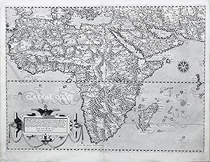
No binding. Condition: Very good. Rome: DUCHETTI, Claudio (active c.1565-c.1579). First state; etched and engraved map on two sheets joined (19 1/8" x 24 3/4" sheet; 30 1/2" x 36" framed) with 32-wind compass rose including the initials of wind names in traditional Italian patois. Condition: very good; chips on frame. Extremely rare Lafreri-type map of Africa engraved by Henricus Honius of Haarlem (often mistaken for Henricus Hondius) and published by Claudio Duchetti, a nephew of Antonio Lafreri working in Venice from c.1562-c.1572 and subsequently in Rome, taking over part of the Lafreri business after Antonio's death. The design comes from the Camocio/Forlani map of 1563, but it eschews the illustrations of sea-monsters and galleons, limiting the decoration to a large strap-work title cartouche in the South Atlantic, the compass rose in the Indian Ocean, and a small depiction of the palace of Prester John located just north of the Equator. After the dissolution of the Lafreri workshop the plate went to Stefano Duchetti who listed the map as "L'Africa no 2 fol real" in his joint catalog with Paolo Graziani. In 1586 it is recorded in the inventory of Pietro de Nobili who adds his signature Petri de Nobilibus Formis to the title cartouche and the lower right quadrant. Bifolco/Ronca describe 3 known copies of the first state.
-

Fiorenza.
Published by Claudij duchetti formis, [c1580]., [Rome],, 1580
Seller: Daniel Crouch Rare Books Ltd, London, United Kingdom
Association Member: ABA ILAB PBFA
Seller rating 4 out of 5 stars
Map
US$ 3,021.43
US$ 26.67 shipping
Ships from United Kingdom to U.S.A.Quantity: 1 available
Add to basketDuchetti's plan of Florence Engraved map, with key below. A bird's-eye view of Florence taken from the north-west, showing the city encircled by the medieval walls with the river Arno flowing through and the hills in the background. The view draws upon the work of the Florentine Francesco Rosselli, who had produced a famous map of the city, 'the Chain Map' of Florence, in the second half of the fifteenth century. The work owes its name to the padlocked chain framing the view; the city is shown with a slightly altered urban layout, thus allowing for the cathedral of Santa Maria del Fiore, with its newly built dome by Brunelleschi, to be in the centre, and the fa�ades of the monuments to be seen frontal. Duchetti probably follows a view of the city attributed to Paolo Forlani from 1567, repeating its errors and distortions and using the coats-of-arms of the Medici and of the city in the same positions. Born in France under the name of Claude Duchet, he was active in Venice c1565-1572 and subsequently in Rome. He was the nephew and part successor to Antonio Lafreri's publishing firm upon the latter's death in 1577. The plate, here in its first state, was purchased by Giovanni Orlandi in 1602 who republished it with the edited imprint; it then went to Hendrick van Schoel; and finally to Francesco de Paoli, though no example exists. Bifolco 1099, 1. 312 by 437mm. (12.25 by 17.25 inches) (printed image).
-

Bononia
Published by Roma, 1582
Seller: Libreria Ex Libris ALAI-ILAB/LILA member, Roma, RM, Italy
Seller rating 5 out of 5 stars
Map
Incisione originale su rame (cm. 47x38,5 pi� ampi margini bianchi). Nel riquadro nell'angolo inferiore destro si legge: 'vero ritratto dela Citta de bologna co tutti gli nomi dele cose principali di essa como al presente si ritrova per claudio duchetto Nepote di Ant. lafreri 1582'. Piccoli restauri professionali lungo la piegatura centrale con due minuscole perdite di parte incisa nella parte della legenda. Nel complesso, esemplare in pi� che buono stato di conservazione, nitidamente impresso. Rara e affascinante pianta della citt� di Bologna nel primo stato di due, precedente l'imprint di Giovanni Orlandi. Bifolco-Ronca, p. 2126.
-
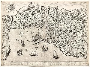
GENOVA
Published by Roma, 1581
Seller: libreria antiquaria perini Sas di Perini, Verona, VR, Italy
Seller rating 5 out of 5 stars
Art / Print / Poster
Incisione in rame ad acquaforte e bulino, mm 408x546, eseguita su carta vergellata, firmata in basso a destra in lastra: Romae, Claudij Ducheti formis 1581. Ambr. Bram. f. Rara pianta prospettica censita in soli 6 esemplari in collezioni pubbliche estere. Primo stato su due. Il titolo appare in alto al centro, mentre a sinistra campeggia lo stemma di Genova. In basso, su dieci colonne, una legenda con 58 rimandi. La pianta deriva chiaramente dalla precedente di Lafreri del 1573, la prima ad inaugurare questo genere di pianta prospettica. La lastra di Lafreri, dopo la sua morte era stata ereditata da Stefano Duchetti (Vedi Bifolco-Ronca, Cartografia e topografia italiana del XVI secolo), per cui Claudio Duchetti incaric� probabilmente Brambilla di incidere una nuova lastra. Successivamente fu acquistata da Giovanni Orlandi e ristampata nel 1602 e poi da lui ceduta a Hendrik Van Schoel ed ancora a De Paoli come risulta da un inventario di vendita del 1633. Bifolco-Ronca, Cartografia e topografia italiana del XVI secolo. Nr.cat: 7038.
-

Candia
Published by Venezia, 1570
Seller: libreria antiquaria perini Sas di Perini, Verona, VR, Italy
Seller rating 5 out of 5 stars
Art / Print / Poster
Copper engraving, mm 283x214. Only state. The cartouche in top right corner bears: "Creta insula, hodie Ca(n)dia in medio Ponto sita est�". Very good impression, incredibly large margins, just a brown stain in left margin. This rare map is based on the Zorzi-Pagano map of 1538, even if oriented with east on top, and clearly derives from the Bonifacio 1568. In this period Duchetti was active in Venice with Forlani, to whom Woodward attributes the plate, which was later brought to Rome, where it was acquired by Orlandi in 1602 and Van Schoel in 1614. 6 copies known in public libraries. Woodward (1992), n. 51; Zacharakis (2009) 1426; Bifolco-Ronca (2018), 722. Nr.cat: 4025.
-
Il vero ritratto di Cales preso � Inglesi del Re Cristianissimo.
Published by incisione, Calais - Francia
Seller: Sergio Trippini, Gavirate, VA, Italy
Seller rating 4 out of 5 stars
Veduta prospettica della fortezza di Calais nel momento della riconquista da parte dell'esercito francese: "Et in questo modo Cales, fortezza reputata inespugnabile, perduta da un Filippo Redi Francia il giorno terzo di Agosto l'anno 1347, con l'assedio di un anno intero, fu perduta sotto Filippo Re d'Inghilterra con un solo assedio di tre giorni il d� otto di Gennaio 1558, per colpa de gl'Inglesi, che non avevan voluto ascoltare il consiglio del Re loro, i quali perderono con perder questa nobil fortezza il passo di poter piu traghettarsi con gli esserciti a muover guerra nella Francia come erano soliti di far per l'adietro?" (Delle Historie del Mondo di M. Mambrino Roseo da Fabriano). In semplice targa, nell'angolo in basso a sinistra, si trova il titolo con rubrica A-H, mentre sulla destra, sempre in semplice targa, il proseguimento della rubrica I-P.Incisione edita per la prima volta a Roma da Lafrery nel 1560 ca, mentre il nostro esemplare nella ristampa "Romae Claudj Duchetti formis" nell'edizione "Joannes Orlandi formis" Romae 1602. Rif: Arrigoni, Bertarelli "Le stampe storiche conservate nella Raccolta del Castello Sforzesco", p. 3, n� 23 - Borroni, "Carte Piante e Stampe storiche delle raccolte lafreriane?", p. 88, n� 266.
![Seller image for [Large album with 16th-century maps and engravings of Italy]. for sale by Antiquariaat FORUM BV](https://pictures.abebooks.com/inventory/md/md32284654950.jpg)
