
Order Total (1 Item Items):
Shipping Destination:

F W Streit (26 results)
Skip to main search results
Search filters
Product Type
- All Product Types
- Books (14)
- Magazines & Periodicals (No further results match this refinement)
- Comics (No further results match this refinement)
- Sheet Music (No further results match this refinement)
- Art, Prints & Posters (1)
- Photographs (No further results match this refinement)
- Maps (11)
- Manuscripts & Paper Collectibles (No further results match this refinement)
Condition Learn more
- New (3)
- As New, Fine or Near Fine (6)
- Very Good or Good (2)
- Fair or Poor (No further results match this refinement)
- As Described (15)
Binding
Collectible Attributes
- First Edition (3)
- Signed (No further results match this refinement)
- Dust Jacket (No further results match this refinement)
- Seller-Supplied Images (15)
- Not Print on Demand (25)
Language (3)
Price
- Any Price
- Under US$ 25 (No further results match this refinement)
- US$ 25 to US$ 50
- Over US$ 50
Free Shipping
Seller Location
Seller Rating
-

European Capital Markets
Seller: Ria Christie Collections, Uxbridge, United Kingdom
Seller rating 5 out of 5 stars

US$ 134.23
US$ 16.11 shipping
Ships from United Kingdom to U.S.A.Quantity: Over 20 available
Add to basketCondition: New. In.
-
US$ 155.18
US$ 33.63 shipping
Ships from United Kingdom to U.S.A.Quantity: 1 available
Add to basketHardcover. Condition: Like New. Like New. book.
-

European Capital Markets
Language: English
Published by Palgrave Macmillan UK, 2000
ISBN 10: 0333924363 ISBN 13: 9780333924365
US$ 153.39
US$ 57.07 shipping
Ships from Germany to U.S.A.Quantity: Over 20 available
Add to basketGebunden. Condition: New. WERNER G. SEIFERT is CEO, the German Stock Exchange, Frankfurt, Germany.ANN-KRISTIN ACHLEITNER is Professor of Banking and Finance, European Business School, Oestrich-Winkel, Germany.FRANK MATTERN is Director, Financial Institutions Group, M.
-

Historischer und geographischer Atlas von Europa ZWEI B�NDE Zweiter Band - Erste Abtheilung / Zweiter Band - Zweite Abtheilung
Published by Berlin/ W. Natorff und Comp., u. 1837., 1836
Seller: Fachbuchhandlung H. Sauermann, Radebeul, Germany
Association Member: BOEV
Seller rating 4 out of 5 stars

664 S. u. 735 S. 8�. Ln. Die B�nde ist an den Ecken und am Buchr�cken leicht besto�en und berieben. Die Seiten sind teilweise fleckig und nachgebr�unt. Mit Besitzervermerk. Ansonsten guter Zustand.
-

Map of Frankreich
Published by Published by J.C. Hinrichs'sche Buchhandlung, Leipzig, 1840
Seller: Keoghs Books, Skipton, United Kingdom
Association Member: PBFA
Seller rating 5 out of 5 stars
Map First Edition
US$ 41.57
US$ 37.66 shipping
Ships from United Kingdom to U.S.A.Quantity: 1 available
Add to basket, 39 x 47.5 cm engraved map with hand coloured political boundaries, Inset map of Corsica, double page plate on guard mount with margins cropped, text in German First Edition thus , a few brown spots near bottom edges, otherwise map in very good condition 39 x 47.5 cm Map ISBN:
-
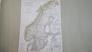
Map of Schweden und Norwegen
Published by Published by J.C. Hinrichs'sche Buchhandlung, Leipzig, 1840
Seller: Keoghs Books, Skipton, United Kingdom
Association Member: PBFA
Seller rating 5 out of 5 stars
Map First Edition
US$ 41.57
US$ 37.66 shipping
Ships from United Kingdom to U.S.A.Quantity: 1 available
Add to basket, 51 x 38 cm engraved map with hand coloured political boundaries, double page plate on guard mount, text in German First Edition thus , a few faint brown spots, ink spot to upper marginotherwise map in very good condition 51 x 38 cm Map ISBN:
-
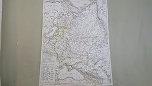
Map of Das Russische Reich in Europa
Published by Published by J.C. Hinrichs'sche Buchhandlung, Leipzig, 1840
Seller: Keoghs Books, Skipton, United Kingdom
Association Member: PBFA
Seller rating 5 out of 5 stars
Map First Edition
US$ 41.57
US$ 37.66 shipping
Ships from United Kingdom to U.S.A.Quantity: 1 available
Add to basket, 47.5 x 36 cm engraved map with hand coloured political boundaries, double page plate on guard mount with margins cropped, text in German First Edition thus , a few faint brown spots, otherwise map in very good condition 47.5 x 36 cm Map ISBN:
-

Historischer und geographischer Atlas von Europa. Bd 1. (Textband 1 von 3).
Published by Bln: Natorff, 1834
Seller: Antiquariat Bergische B�cherstube Mewes, Overath, Germany
Association Member: GIAQ ILAB VDA
Seller rating 5 out of 5 stars
(2 Bll.), 1009 S., lith. Titel. HLdr.d.Zt. *Der Kartenband erschien 1837*. Sprache: Deutsch.
-
Historischer und geographischer Atlas von Europa. (Mit 1 gestochenen Vortitel in Bd. 1, sonst v�llig unbebildertes beschreibendes Werk).
Published by W. Natorff u. Comp. 1836-1837., Berlin,, 1836
Seller: Antiquariat Johannes Herlyn, Freiburg, Germany
Seller rating 4 out of 5 stars
fester Einband. 2 B�nde in 3 (2. Band in 2 Abtheilungen). (IV), 1010; (1 Bl.), 663; (VIII), 735 S. kr�ftig marmorierte priv. Pp. d.Zt. mit gr�nen Rsch.; gr�ner Ganzfarbschnitt. Bd. 1 u. 2.1 in 2. Aufl., Bd. 2.2 in 1. Aufl. Ecken besto�en, R�cken von Bd. 1 mit starker Reiblinie (mittig senkrecht); Vors�tze gebr�unt, sonst innen gut. Die Kapitel �ber die einzelnen europ�ischen L�nder gliedern sich jeweils in Geographie und Geschichte; Bd. 2.1 gilt weitgehend den damaligen deutschen L�ndern (mit breitem Raum f�r Preu�en) und �sterreich.
-
Atlas von Europa in zwei und achtzig Bl�ttern.
Published by Natorff Bln, 1837
Seller: Heilbronner Antiquariat - Michael Wahl, Heilbronn, Germany
Seller rating 5 out of 5 stars
Mit gestochenem Titel, 78 grenzkolorierte Kupfersticharten u. 4 gestochenen �bersichten. Quer-4�. Hldr.d.Zt. Berieben u. bestossen. Durchgehend wenig bis st�rker stockfleckig. Die "Spanien und Portugal" Karten sind numerisch falsch eingebunden. *** 40 Jahre - Heilbronner Antiquariat - Michael Wahl - 1983-2023 ***.
-
Atlas von Europa in zweiundachtzig Bl�ttern.
Published by Berlin Natorff, 1837
Seller: Neusser Buch & Kunst Antiquariat, Neuss, NRW, Germany
Seller rating 5 out of 5 stars
0. 33 x 26,5 cm. 82 Bl. �berwiegend Kt.m. Grenzkolorit. Complete with engraved title page an 82 copper engravings . Halbleder, Deckeltitel, Kanten berieb.+bestoss., Karten tls. gebr�nt o. stockfl., insgesamt gut erh., Sprache: Deutschu 2,000 gr.
-
Historischer und geographischer Atlas vin Europa ( keine landkarten )
Published by W. Natorff und Comp. Verlag, 1837
Condition: Orig. halbledereinband. 8° 1 735 S. Ecken und Kanten besto�en.
-
Charte vom Preussischen Staate, oder Gebirgs- und Fluss-Charte des n�rdlichen Teutschlands, neu entworfen und gezeichnet von F. W. Streit. Vermehrt und berichtigt bis zum Jahre 1832. Gestochen von H. Leutemann
Language: German
Published by Leipzig, J. C. Hinrichssche Buchhandlung, 1832
Seller: ANTIQUARIAT Franke BRUDDENBOOKS, L�beck, Germany
Seller rating 5 out of 5 stars
Map
63 x 44cm. Condition: Gut. 1 Blatt mehrfach gefaltete, farbige Karte, altersbedingt leicht fleckig, keine Einrisse, sehr seltene und erstaunlich gut erhaltene Karte, gutes Sammlerst�ck Wir senden umgehend mit beiliegender MwSt.Rechnung. Sprache: Deutsch Gewicht in Gramm: 150.
-
(Hrsg.) Historischer und geographischer Atlas von Europa. 2 B�nde. (in 3).
Language: German
Published by Natorff, Berlin, 1834
Seller: Antiquariat Renner OHG, Albstadt, Germany
Association Member: BOEV
Seller rating 5 out of 5 stars
Hardcover. Condition: Befriedigend. Bln., Natorff 1834-37. 1 Bl., 1009 S., 1 Bl.; 664 S.; 2 Bl. 735 S. Halblederband der Zeit. (berieben, Ecken leicht besto�en, R�cken mit kleinen Einrissen an den Kapitalen und am Au�engelenk).- Bd. II,1: 2 Blatt (Titel und Inhaltsverzeichnis) fehlen.- Vors�tze etwas fleckig, Besitzvermerk auf Vorsatz, etwas eng gebunden, Bd. II: Titel mit kleinem Eckabri�, einige Seiten etwas stockfleckig.
-
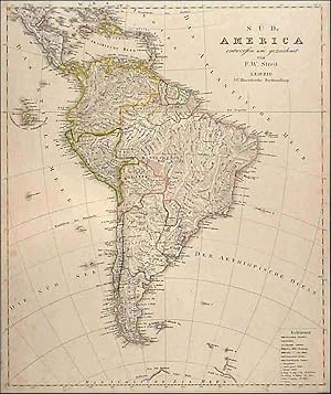
'S�D-AMERICA.'. Nice map of South America including the 'Schildkroten or Galapagos Islands.
Published by F. W. Streit in Leipzig ca. 1830, 1830
Map
US$ 103.91
US$ 40.35 shipping
Ships from United Kingdom to U.S.A.Quantity: 1 available
Add to basketCondition: Fine. 47x39cm. Original outline Colour. Uncommon.
-
'CHARTE VON FRANKREICH.'. Map of France.
Published by Friedrich Wilhelm Streit for Verlag des Geograph. Instituts Weimar 1817, 1817
Map
US$ 103.91
US$ 40.35 shipping
Ships from United Kingdom to U.S.A.Quantity: 1 available
Add to basketCondition: Fine. 48x58cm. Original outline colour. Excellent condition.
-
Lehrbuch der reinen Mathematik, f�r den Selbstunterricht bearbeitet. Bd 7 - 9 (v. 10) in 1 Bd. Weimar, Landes-Industrie-Comptoir,.
Published by - 1823, 1820
Seller: Zentralantiquariat Leipzig GmbH, Leipzig, Germany
Seller rating 5 out of 5 stars
236; 10, 326; 16, 184 S. Mit zus. 9 gef. Kupfertaf. Hldrbd d. Zeit m. Rverg. (etwas beschabt, St. a. d. T., �berstehende Tafelr�nder geknickt). 7. Die ebene und sph�rische Trigonometrie.- 8. Die Anfangsgr�nde der practischen Messkunst.- 9. Die Lehre von den Kegelschnitten nebst einem Anhange von einigen andern krummen Linien.- Poggendorff II, 1026. Sprache: Deutsch.
-

'CHARTE VON DEM K�NIGREICHE W�RTTEMBERG UND DEM GROSHERZOGTHUME BADEN'. Map of Baden-W�rttemberg, designed by F. W. Streit and published by
Published by Verlag des Geograph. Instituts Weimar 1818, 1818
Map
US$ 124.70
US$ 40.35 shipping
Ships from United Kingdom to U.S.A.Quantity: 1 available
Add to basketCondition: Fine. 53x49cm. Original outline colour. Excellent condition.
-
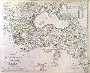
'CHARTE DES OSMANISCHEN REICHS IN EUROPA U. ASIEN.'. Turkey in Europe and Asia. - together with a double sided page if explanation.
Published by F. W. Streit in Leipzig ca. 1830, 1830
Map
US$ 138.55
US$ 40.35 shipping
Ships from United Kingdom to U.S.A.Quantity: 1 available
Add to basketCondition: Fine. 39x48cm. Original outline Colour. small tears at top of map repaired and two very small ink marks - otherwise good.
-
US$ 33.53
Free Shipping
Ships from United Kingdom to U.S.A.Quantity: Over 20 available
Add to basketPaperback. Condition: New. Print on Demand. This book delves into the vast and multifaceted history of Europe, tracing its evolution from its humble origins to the vibrant and influential continent it is today. The author expertly guides readers through the key events, cultural shifts, and intellectual movements that have shaped Europe over millennia, providing a comprehensive narrative that is both accessible and engaging. The book explores the rise and fall of empires, the spread of religions, the impact of wars and revolutions, and the development of art, science, and philosophy. It examines the complex interactions between different European nations and cultures, highlighting the shared experiences and the unique contributions that each has made to the collective European heritage. Through its exploration of the past, this book sheds light on the present, helping readers understand the roots of contemporary European society and the challenges and opportunities it faces. It is a valuable resource for anyone seeking a deeper understanding of Europe's rich and multifaceted history. This book is a reproduction of an important historical work, digitally reconstructed using state-of-the-art technology to preserve the original format. In rare cases, an imperfection in the original, such as a blemish or missing page, may be replicated in the book. print-on-demand item.
-

K?nigreich Polen nach den besten Hilfsmittel
Published by Leipzig, 1848
Seller: libreria antiquaria perini Sas di Perini, Verona, VR, Italy
Seller rating 5 out of 5 stars
Art / Print / Poster
Incisione, mm 520x430; dipinta d'epoca; piccola pianta di varsavia entro riquadro a destra; ben conservata; tratta da: Stein, Neuer Atlas der ganzen Erde Nr.cat: Cod 7500.
-
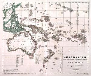
'AUSTRALIEN NACH DEN NEUESTEN H�LFSMITTELN ENTWORFEN'. Australia, New Zealand and Polynesia, reaching to Hawaii. Drawn by Arno Streit after
Published by Friedrich Wilhelm Streit in Leipzig 1834, 1834
Map
US$ 207.83
US$ 40.35 shipping
Ships from United Kingdom to U.S.A.Quantity: 1 available
Add to basket38x45cm. Original outline colour. Excellent condition.
-
Historischer und geographischer Atlas von Europa.
Published by Berlin Natorff, 1834
Seller: Neusser Buch & Kunst Antiquariat, Neuss, NRW, Germany
Seller rating 5 out of 5 stars
0. 3 B�nde. 8� 1009/664/735 Seiten Halbledereinband der Zeit. Einband mit Goldpr�g., 3seitiger Gr�nschnitt, marmorierte Deckel, Einband berieben und bestossen, kleiner Stempel, Seiten leicht fleckig. Sprache: Deutschutsch 2,300 gr.
-
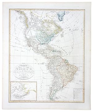
Charte von America (1810)
Publication Date: 1810
Seller: Tmecca Inc., Seoul, Korea, Republic of
Association Member: ILAB
Seller rating 2 out of 5 stars

Map
US$ 450.00
US$ 19.99 shipping
Ships from Korea, Republic of to U.S.A.Quantity: 1 available
Add to basketNo Binding. Condition: As New. 55 x 67 cm.
-
Antique Map-UNITED-STATES-VEREINIGTEN STAATEN-Streit-1843
Publication Date: 1843
Seller: Pictura Prints, Art & Books, Overasselt, Netherlands
Seller rating 5 out of 5 stars
Dr. F.W. Streit (illustrator). 'DIE VEREINIGTEN STAATEN VON NORD-AMERIKA . . . 1843'A detailed political and geographical map of the United States as it appeared in 1843, featuring inset maps of Washington DC, Boston, Philadelphia, and New York. Includes notable features like two Salt Lakes and early cartographic misconceptions about rivers connecting to the Pacific Ocean.Made by an anonymous engraver after Dr. F.W. Streit.Medium: Engraving with outline color on hand-laid (verge) paper.Sheet size: 50.5 x 42 cm (19.88 x 16.54 inch). Image size: 46 x 39.3 cm. (18.11 x 15.47 inch).UNITED STATES, TEXAS REPUBLIC, 19TH-CENTURY MAP, PRE-TREATY OF GUADALUPE HIDALGO, AMERICAN CARTOGRAPHY, DR. F.W. STREIT, LEIPZIG MAP, HISTORICAL US MAP | EXPO-MAPSBACKGROUND INFORMATIONPublished by J.C. Hinrichs'sche Buchhandlung, Leipzig, 1843.Biography artist: Dr. F.W. Streit was a German mathematician, cartographer, and engineer in the Prussian artillery. Condition: very good, given age. Light wear along the edges. Light foxing, creasing and soiling. Tear in the bottom left margin. Paper edges with some chipping. General age-related toning and/or occasional minor defects from handling. Please study scan carefully.
-

1851 Die Vereinigten Staaten von Nord-Amerika
Seller: New World Cartographic, Chicago, IL, U.S.A.
Seller rating 4 out of 5 stars
Map
By: Dr. F.W. StreitDate: 1851 (dated) Leipzig, GermanyDimensions: 15.5 x 18.75 inches (39.5 x 47.5 cm)This is a late and rare edition of Dr. Streits interesting and unusual map of the United States. Dr. F.W. Streit was a mathematician, cartographer, and engineer in the Prussian artillery. The map presents much of the continental United States, omitting the Southwest and instead, providing four inset maps of Washington D.C., New York, Boston, and Philadelphia to Trenton.While the map is dated 1851, it doesnt seem to have been properly updated. Though the map post-dates the Mexican-American War and Texas joining the Union, what little it shows of the southwest better reflects the region while still under Mexican control. Texas is depicted with border similar to those found on maps in thelate 1830s and is not listed as part of the United States in the key at top right.In the east, each state is clearly presented in a contrasting color, corresponding with the key provided. The trans-Mississippi West is shows to mostly consist of the unorganized Missouri Territory that would change in three years with the passing of the Kansas-Nebraska act. The Oregon Territory is accurately shown as part of the United States, without the extension into British Columbia that we find in other maps of the era.In the district of California, Dr. Streit depicts many rivers, some topography, and the locations of Native American Tribes. Interestingly, Streit also shows two versions of the fictitious "River of the West," that was debunked by the Fremont Expedition in the decade prior. One, the Timbango flows from Timbagos Sea to San Francisco Bay, and further south, the Bonaventura flows from the Tegijo Sea to somewhere along Californias central coast.Condition: Map is in A+ condition with bright original color on clean paper presenting ample margins on all sides and no tears, holes, or stains.Inventory #123511200 W. 35th Street #425 Chicago, IL 60609 | P: (312) 496 - 3622.


