Order Total (1 Item Items):
Shipping Destination:

Jode Cornelius (4 results)
Skip to main search results
Search filters
Product Type
- All Product Types
- Books (1)
- Magazines & Periodicals (No further results match this refinement)
- Comics (No further results match this refinement)
- Sheet Music (No further results match this refinement)
- Art, Prints & Posters (1)
- Photographs (No further results match this refinement)
- Maps (2)
- Manuscripts & Paper Collectibles (No further results match this refinement)
Condition Learn more
- New (No further results match this refinement)
- As New, Fine or Near Fine (No further results match this refinement)
- Very Good or Good (No further results match this refinement)
- Fair or Poor (No further results match this refinement)
- As Described (4)
Binding
- All Bindings
- Hardcover (1)
- Softcover (No further results match this refinement)
Collectible Attributes
- First Edition (No further results match this refinement)
- Signed (No further results match this refinement)
- Dust Jacket (No further results match this refinement)
- Seller-Supplied Images (3)
- Not Print on Demand (4)
Language (1)
Price
- Any Price
- Under US$ 25 (No further results match this refinement)
- US$ 25 to US$ 50 (No further results match this refinement)
- Over US$ 50
Free Shipping
- Free Shipping to U.S.A. (No further results match this refinement)
Seller Location
Seller Rating
-

Primae Partis Asiae.
Published by 1593]., [Antwerp,, 1593
Seller: Daniel Crouch Rare Books Ltd, London, United Kingdom
Association Member: ABA ILAB PBFA
Seller rating 4 out of 5 stars

Map
US$ 4,131.62
US$ 26.74 shipping
Ships from United Kingdom to U.S.A.Quantity: 1 available
Add to basketDe Jode's rare map of west Asia Double page engraved map; small tear to top left border not affecting the image, skillfully repaired. The map shows the Holy Land and the Middle East from Turkey to Persia, including the Mediterranean Sea and Cyprus in the west, the Black and Caspian Seas in the north, and part of Egypt and the Persian Gulf in the south. The map is based on Giacomo Gastaldi's three-sheet map of Asia. The westernmost part, which is covered by the present example, was first issued in 1559, whereas the following two were published in 1561. Later on, in 1565, Lafreri added two narrow sheets covering the area south of the equator, including most of the Indonesian islands. The map appeared in the second edition of the de Jodes' atlas 'Speculum orbis terrae'. The 'Speculum' was first published in 1578 by Gerard de Jode (1509-1591) with text by Daniel Cellarius. It was designed to compete with Abraham Ortelius' atlas, 'Theatrum Orbis Terrarum', which had been published eight years earlier. Ortelius used his influence to disrupt de Jode's application for a royal privilege. By the time this was finally granted, seven years after the publication of the 'Theatrum', Ortelius' work had become so popular that de Jode's atlas did not sell well, despite the accuracy and clarity of his maps. His son Cornelis (1558-1600) continued his father's publishing business after studying at Douai. He produced an enlarged edition of the 'Speculum' in 1593, which Gerard had been planning before his death. Either Cornelis or Gerard was the first person to make a globe following the geography of Mercator in the southern hemisphere; no copies of it survive to provide evidence. Although sales of de Jode's work were less than ideal, the atlas was evidently held in high regard, with several contemporaries citing its importance alongside the atlases of Mercator and Ortelius. Few examples of either edition of the 'Speculum' have survived, making the maps within a rarity. Van der Krogt 8200:32.
-

China Regnum.
Published by Collectore Cornelio de Iudeis, [1593]., Antwerp,, 1593
Seller: Daniel Crouch Rare Books Ltd, London, United Kingdom
Association Member: ABA ILAB PBFA
Seller rating 4 out of 5 stars
Map
US$ 37,184.61
US$ 26.74 shipping
Ships from United Kingdom to U.S.A.Quantity: 1 available
Add to basketDe Jode's rare map of China Double-page engraved map, fine original hand-colour. De Jode first published his 'Speculum' in 1578. Intended as competition to Ortelius' popular 'Theatrum', it faired poorly and sales were disappointing, another edition was produced, after de Jode's death by his son Cornelius in 1593. For this edition, Cornelius introduced several new maps, of which the present item is a superb example. The map is based upon the work of the Portuguese Jorge de Barbuda, whose map of China appeared in the work of de Jode's competitor, Ortelius, in 1584. The circular map is framed by elaborate strap-work and four vignettes of Far Eastern life: fish-catching cormorants; a fishing boat with a chimney-topped cabin with a pen attached to the side sheltering domestic fowl; the worship of a triple-headed deity; and the famous wind carts depicted on many early European maps of the region, including those of Hondius and Speed. Van der Krogt 8410:32.
-

Le Cabinet des plus beaux Portraits de plusieurs Princes & Princesses, Hommes Illustres, Fameux Peintres & autres faits par le fameux Antoine van Dyck, chevalier et peintre du roi qye l'auteur a fait graver � ses propres d�pens. Cette Ouvrage peut aussi servir pour Supplement au Cabinet du Fameux van Dyck, imprimez � Anvers.
Seller: Antiquariaat Wim de Goeij, Kalmthout, ANTW, Belgium
Association Member: ILAB
Seller rating 5 out of 5 stars

La Haye ( 's Gravenhage ) , Chez Alberts & vander Kloot , 1728, in-folio, 40 x 25,5 cm, (8) nn pp (title , Calmet's preface) + 50 full page portrait engravings after portraits made by A. van Dyck. Bound in contemporary full leather, raised gilt spine, red spickled edges, joints cracked, extremities of binding rubbed and worn, some slight dustsoiling at upper margin of some plates, one marginal tear in plate 2 , overall a fine interior. With the armorial bookplate of Samual George Smith. (See Mauquoy-Hendrickx , L'Iconographie D'Antoine Van Dyck, Catalogue raisonn�, 2nd edition, vol. I pp. 44-45). Complete and extremely rare portrait album. Author Mauquoy states in her description that she could not find a complete copy. We can supply you with the list of the 50 portraits upon an e-mail request.
-
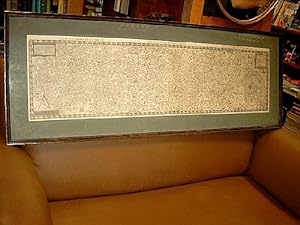
Tractus Rheni: Prima Tabula - Secunda Tabula - Tertia Tabula auf einem Blatt. ( Gro�formatiger Kupferstich mit der gesamten Darstellung des Rheinverlaufs auf 3 Segmenten aus: Speculum Orbis Terrarum / Inferioris Germaniae pars )
Published by Antwerpen, 1578
Seller: Antiquariat Friederichsen e. K., Hamburg, Germany
Association Member: BOEV
Seller rating 5 out of 5 stars
Art / Print / Poster
( Die Karte selbst wurde von de Jode ca. 1569 erstellt laut Inschrift de Jodes unterhalb des linken Meilenzeigers ) Die Kupferstichkarte zeigt den gesamten Rheinverlauf von der Quelle des Rheins im Tomasee ( Graub�nden ) in der Schweiz �ber den Bodensee, �ber Basel, Stra�burg, Speyer, Mainz, K�ln, D�sseldorf bis hin zu den M�ndungsarmen des Rheins mit u.a. dem Waal und St�dten wie Utrecht und Antwerpen. Der *Tertia Tabula*-Teil der Karte mit der M�ndung des Rheins in die Nordsee mit etlichen Inseln ( u.a. Texel ) sowie einem Seeungeheuer und 3 Schiffen auf der Nordsee nebst sch�ner Windrose. Rechts oben mit Titelkartusche *Inferioris Germaniae pars.* und Meilenzeiger, links oben mit Titelei *Tractus Rhenanus multos olim Romanus.*, links unten mit Zirkel und Meilenzeiger und Textzeile *Gerardus de Jode excudebat Anno Do. 1569*. Auf dem Blatt noch 2 weitere Himmelsrichtungsanzeiger sowie zahlreiche kleine Wappen. Die zweifach gefaltete Karte misst gesamt 34 x 130 cm ( H�he x Breite ), alt unter Passepartout und Glas gerahmt ( Rahmenma� betr�gt ca.: 55 x 150 cm unge�ffnet ). Die Karte verso mit altem gedrucktem Text, die Karte gleichm��ig gebr�unt ( die rechte H�lfte der Karte etwas st�rker gebr�unt ) und von insgesamt guter Erhaltung mit 2 Mittelfalzen. 4 fingernagelgro�e kleine Stellen auf dem ersten Teilst�ck sind ausgebliichen und aufgehellt. Das Passepartout st�rker fleckig ( m�sste erneuert werden ), der Rahmen gering besto�en. - Eine vollst�ndige Rheinkarte de Jodes wie hier vorliegend ist von �u�erster Seltenheit - ( Lagerort KG )( Bitte beachten: Hier ist leider kein Versand m�glich - hier bitte nur Selbstabholung oder selbst organisierter Abtransport nach Absprache ) ( Weitere Bilder auf Anfrage ) / Artikel 12253 /// (The map itself was created by de Jode around 1569, according to de Jode's inscription below the left scale.) The copperplate engraving shows the entire course of the Rhine from its source in Lake Toma (Graub�nden) in Switzerland, through Lake Constance, via Basel, Strasbourg, Speyer, Mainz, Cologne, and D�sseldorf, to the Rhine's distributaries, including the Waal and cities such as Utrecht and Antwerp. The *Tertia Tabula* section of the map depicts the Rhine's mouth into the North Sea with several islands (including Texel), a sea monster, three ships on the North Sea, and a beautiful compass rose. The map features a title cartouche in the upper right corner, bearing the inscription *Inferioris Germaniae pars.* and a scale of miles. The upper left corner displays the title *Tractus Rhenanus multos olim Romanus.*, while the lower left corner shows a compass, scale of miles, and the text line *Gerardus de Jode excudebat Anno Do. 1569*. The sheet also contains two additional cardinal directions and numerous small coats of arms. The map, folded twice, measures 34 x 130 cm (height x width) and is framed with glass and a mat (frame dimensions approximately 55 x 150 cm unopened). The verso of the map bears old printed text. The map is evenly browned (the right half being slightly more so) and is in generally good condition with two center folds. Four small, fingernail-sized areas on the first section are faded and lightened. The passe-partout is heavily stained (needs to be replaced), the frame has minor damage. - A complete Rhine map by de Jode, such as the one presented here, is extremely rare - (Location: KG) (Please note: Shipping is unfortunately not possible - collection only or self-arranged transport by prior arrangement) (Further pictures available upon request) / Item 12253.