Order Total (1 Item Items):
Shipping Destination:

Knipe J a (15 results)
Author:
knipe j a
Refine with Advanced Search
Skip to main search results
Search filters
Product Type
- All Product Types
- Books (11)
- Magazines & Periodicals (No further results match this refinement)
- Comics (No further results match this refinement)
- Sheet Music (No further results match this refinement)
- Art, Prints & Posters (No further results match this refinement)
- Photographs (No further results match this refinement)
- Maps (4)
- Manuscripts & Paper Collectibles (No further results match this refinement)
Condition Learn more
Binding
Collectible Attributes
- First Edition (2)
- Signed (No further results match this refinement)
- Dust Jacket (No further results match this refinement)
- Seller-Supplied Images (11)
- Not Print on Demand (15)
Language (2)
Free Shipping
- Free Shipping to U.S.A. (No further results match this refinement)
Seller Location
Seller Rating
-

Mass Market Paperback. Condition: Good. A bit scuffed but all pages intact and legible. Good reading copies. Clean. Store Stamped. --- --- MURDER WITHOUT RESERVATION --- (Tony and Pat Pratt Mystery) --- Tony Pratt was helping out on a movie set. With only three more sequences left to shoot, the picture looked like a wrap. But that was before somebody shot the horse and the drug dealer, before Tony went crashing through white-water rapids to save a terrified boy from drowning, before the runaway grass fire and way before somebody dumped a pair of deadly rattlesnakes in the Pratts' bedroom. --- MURDER NOW AND AGAIN --- Fear sweeps a small town when a first-rate guy is found murdered in a second-hand shop. . .
-
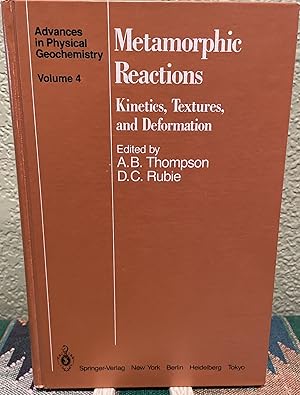
Metamorphic Reactions Kinetics, Textures, and Deformation
First Edition
US$ 59.00 25% offUS$ 44.25
US$ 5.05 shipping
Ships within U.S.A.Quantity: 1 available
Add to basketHardcover. Condition: Very Good+ with no dust jacket. First Edition (?); Second Printing. Unmarked. Very mild wear on corners from shelving. Otherwise like new. ; Book Description; Spine has no signs of creasing. Pages are clean and not marred by notes or folds. Covers are square with minor wear. Ships Safe and Fast. Published without Dust Jacket. ; Advances in Physical Geochemistry; Textbook; B&W Illustrations; 9.75 X 6.50 X 0.75 inches; 291 pages DC2.
-

The Behaviour and Influence of Fluids in Subduction Zones: Proceedings of a Royal Society Discussion Meeting, held on 8 and 9 November 1990.
Language: English
Published by London: The Royal Society, 1991
ISBN 10: 0854034374 ISBN 13: 9780854034376
Seller: Antiquariat Thomas Haker GmbH & Co. KG, Berlin, Germany
Association Member: GIAQ
Seller rating 5 out of 5 stars

Cloth. Condition: Sehr gut. 418 pages. Very good. Minimal wear. Inside clean. Sprache: Englisch Gewicht in Gramm: 699.
-
The Nature and Tectonic Significance of Fault Zone Weakening
Language: English
Published by Geological Society of London, London, 2001
ISBN 10: 1862390908 ISBN 13: 9781862390904
US$ 99.00 25% offUS$ 74.25
US$ 5.05 shipping
Ships within U.S.A.Quantity: 1 available
Add to basketHardcover. Condition: Very Good+ with no dust jacket. Unmarked, except for initials on inside cover page. ; Many faults appear to form persistent zones of weakness that fundamentally influence the distribution, architecture and movement patterns of crustal-scale deformation and associated process in both continental and oceanic regions. This book brings together papers by an international group of Earth Scientists to discuss a broad range of topics centred upon the controls of fault weakening and the role of such faults during lithosphere deformation. Readership: Academic structural-tectonic geologists, microstructural geologists, rheologists, geophysicists and people studying geodynamics. Also, petroleum geologists, hardrock geologists, mining geologists, hydrogeologists and metamorphic geologists. Suitable for postgraduate students. ; Geological Society Special Publication, No. 186; Textbook; B&W Photographs; 9.90 X 6.70 X 1 inches; 344 pages DC2.
-

The Organisation of Government: An Introduction
Language: English
Published by Van Schaik Publishers, 2000
ISBN 10: 0627024807 ISBN 13: 9780627024801
First Edition
Softcover. Condition: Fair. No Jacket. First Edition. Wraps are shelf rubbed with a large crease on the top of the wraps, and 3 stickers on the back. Binding remains secure. Small Damp stains on the the bottom of the pages, but the pages remain tidy overall with no inscriptions or annotations. JHK. Our orders are shipped using tracked courier delivery services.
-

The Organisation of Government: An Introduction
Language: English
Published by J L van Schaik Uitgewers / Publishers, 2006
ISBN 10: 0627024807 ISBN 13: 9780627024801
Softcover. Condition: Very Good. 2nd impression . The wraps are a touch edge worn. Internally clean and complete. There are no markings and inscriptions. The binding is secure. GK. Our orders are shipped using tracked courier delivery services.
-
The Nature and Tectonic Significance of Fault Zone Weakening. Geological Society Special Publication, Vol. 186;
Seller: books4less (Versandantiquariat Petra Gros GmbH & Co. KG), Welling, Germany
Seller rating 5 out of 5 stars
gebundene Ausgabe. Condition: Gut. 342 Seiten; Der Erhaltungszustand des hier angebotenen Werks ist trotz seiner Bibliotheksnutzung sehr sauber. Es befindet sich neben dem R�ckenschild lediglich ein Bibliotheksstempel im Buch; ordnungsgem�� entwidmet. Einband folienkaschiert; In ENGLISCHER Sprache. Sprache: Englisch Gewicht in Gramm: 940.
-

The Nature and Tectonic Significance of Fault Zone Weakening.
Language: English
Published by London: Geological Society, 2001
ISBN 10: 1862390908 ISBN 13: 9781862390904
Seller: Plurabelle Books Ltd, Cambridge, United Kingdom
Association Member: GIAQ
Seller rating 5 out of 5 stars
US$ 87.90
US$ 10.67 shipping
Ships from United Kingdom to U.S.A.Quantity: 1 available
Add to basketHardcover. Condition: Very Good. Series: Geological Society Special Publication vi 344p large format hardback, laminated boards with colourful illustration, excellent fresh copy, light library markings only, never used, almost as new Language: English.
-
US$ 91.43
US$ 13.33 shipping
Ships from United Kingdom to U.S.A.Quantity: 2 available
Add to basketPaperback. Condition: Brand New. reprint edition. 291 pages. 9.20x6.10x0.70 inches. In Stock.
-
Kartoniert / Broschiert. Condition: New.
-
The Nature and Tectonic Significance of Fault Zone Weakening (Geological Society Special Publication, No. 186)
Language: English
Published by Geological Society of London, 2001
ISBN 10: 1862390908 ISBN 13: 9781862390904
Seller: Phatpocket Limited, Waltham Abbey, HERTS, United Kingdom
Seller rating 5 out of 5 stars
US$ 104.10
US$ 14.19 shipping
Ships from United Kingdom to U.S.A.Quantity: 1 available
Add to basketCondition: Good. Your purchase helps support Sri Lankan Children's Charity 'The Rainbow Centre'. Ex-library, so some stamps and wear, but in good overall condition. Our donations to The Rainbow Centre have helped provide an education and a safe haven to hundreds of children who live in appalling conditions.
-
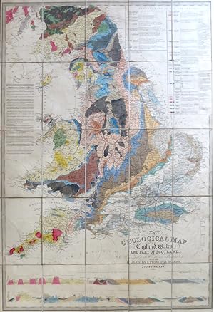
A Geological Map of England, Wales, and Part of Scotland, Showing also the Inland Navigation with the Railroads & Principal Roads
Published by London: J. & C. Walker, March 15th, 1838
Seller: Bow Windows Bookshop (ABA, ILAB), Lewes, United Kingdom
Association Member: ABA ILAB PBFA
Seller rating 5 out of 5 stars
Map
US$ 2,060.06
US$ 29.33 shipping
Ships from United Kingdom to U.S.A.Quantity: 1 available
Add to basketMap dimensions 93 x 65 cm, overall dimensions 101 x 66 cm. Large folding geological map with two cross-sections to the lower edge the strata of southern England from Land's End to the German Ocean and those along the spine of the country from Cumberland down to Newhaven, all vividly coloured according to the strata, dissected into 30 sections and mounted on linen, textured green paper to the folded end sections, folds into the original dark green cloth slipcase with a gold lettered label to the upper panel. Slight wear to the case, some light soiling to the map, very good overall. A less common and slightly smaller variant of James Alexander Knipe's map, first published in 1835 and thence frequently updated and reissued using fresh evidence gathered from geological fieldwork. As with the original map, Knipe's name has here been completely excised and only those of the publishers remain. Here the title has also been shortened, removing references to rivers and canals - a clear indication of how rail and road had very quickly become the principal means of inland navigation. This map also benefits from the second north to south cross section, not included on the larger version, which includes the London Basin towards the right edge.
-
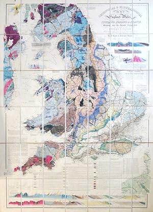
Geological & Mineralogical Map of England & Wales, With Parts of Scotland, Ireland & France, Showing also the Inland Navigation By Means of Rivers & Canals, With the Elevation in Feet Above the Sea, the Rail Roads & Principal Roads
Published by London: J.A. Knipe [and] E. Stanford Jany. 1st, 1854, 1854
Seller: Bow Windows Bookshop (ABA, ILAB), Lewes, United Kingdom
Association Member: ABA ILAB PBFA
Seller rating 5 out of 5 stars
Map
US$ 2,403.41
US$ 29.33 shipping
Ships from United Kingdom to U.S.A.Quantity: 1 available
Add to basketMap dimensions 107 x 78 cm, overall 113 x 85 cm. Folding map with rich geological hand colouring, cross section in two rows showing the strata from Land's End to the North Sea along the lower edge, above this three panels comprising an explanation to the colouring of the map, three smaller cross sections to the upper right corner adjacent to the title, dissected into 42 sections and mounted on linen, marbled paper to the folded end sections, folds into original plum cloth slipcase with a yellow Stanford's printed label to the upper panel and a brief handwritten label to the foot. Some light wear and fading to the case, a very good example of a striking map. Published in editions from the late 1830s onwards, this is one of Knipe's less common geological maps of the country and unusually features his own name in the imprint.
-
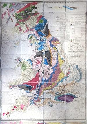
A Geological Map of England & Wales, and Part of Scotland, Showing also the Inland Navigation by Means of Rivers and Canals, with their Elevation in Feet Above the Sea Together with the Rail Roads & Principal Roads
Published by London: J. & C. Walker, March 31st, 1837
Seller: Bow Windows Bookshop (ABA, ILAB), Lewes, United Kingdom
Association Member: ABA ILAB PBFA
Seller rating 5 out of 5 stars
Map
US$ 2,266.07
US$ 29.33 shipping
Ships from United Kingdom to U.S.A.Quantity: 1 available
Add to basketMap dimensions 134.5 x 98 cm, overall 143 x 100 cm. Large folding geological map with a cross-section of southern England from Land's End to the German Ocean across the lower margin, all vividly coloured according to the strata, scale: 10 miles to 1 1/8th inch, the map divided into 36 sections and mounted on linen, textured paper to the folded end sections, folds into the original purple embossed cloth slipcase with a gold lettered paper label to the upper panel. Slight discolouration to the case, otherwise this and the map in very good condition. The map was first published in 1835 and was frequently updated and reissued using fresh evidence gathered from geological fieldwork. It has been suggested that up to nine states had appeared by 1838. This is an intermediate state with Knipe's name excised from the title, but with the Walkers' address given as No. 9 Castle Street, Holborn.
-

A Geological Map of England, Wales and Part of Scotland Showing also the Inland Navigation by means of Rivers and Canals with their elevation in feet above the sea together with the Rail Roads and Principal Roads.
Published by London Published according to Act of Parliament by J. & C. Walker 9 Castle Street Holborn Dec. 31st, 1837
Seller: Shapero Rare Books, London, United Kingdom
Association Member: ABA ILAB PBFA
Seller rating 5 out of 5 stars
Map
US$ 1,716.72
US$ 20.00 shipping
Ships from United Kingdom to U.S.A.Quantity: 1 available
Add to basketHand-coloured engraved map, dissected and mounted on linen, geological section from 'Lands End to the German Sea' in bottom border, key upper right; without slipcase, some folds torn without loss.�Dimensions: 1440 by 1000mm. (56.5 by 39.25 inches). IMPORTANT AND MUCH REPRINTED GEOLOGICAL WALL-MAP OF ENGLAND AND WALES, repaired by James Knipe, and published by him in conjunction with John Walker jr. and Charles Walker, leading London engravers and publishers. However, in this later printing Knipe's name has been been removed from the title, leaving the credit only to the Walkers. In this printing, the plate was heavily re-engraved, with the original title re-engraved, and an additional section added, extending the map northwards to Forfar. Along the lower border is a geological section from 'Lands End to the German Sea' (North Sea) and St. George's Channel to the German Sea, with an extensive colour key, 'Explanation of the Colouring', 'Explanation of the Signs' and, acknowledging the times the map was engraved in, a key to 'Railways Completed or in Progress' and 'Projected Railways.' This was the earliest of Knipe's geological maps; he also produced fine geological maps of Great Britain and Scotland, as well as a second geological map of England and Wales. C.f. BLMC Maps 218.c.4. for 1835 edition.