Lasor Varea (28 results)

Published by Padua: Baptista Conzatti ehemals Frambotti, 1713
- Map
Seller: historicArt Antiquariat & Kunsthandlung, Wiesbaden-Breckenheim, GermanyhistoricArt Antiquariat & Kunsthandlung
Contact seller5-star sellerCondition: Used
US$ 164.63
US$ 13.70 shippingShips from Germany to U.S.A.Quantity: 1 available
1. Original-Kupferstich auf rückseitig bedrucktem Büttenblatt mit dekorativ abgesetztem Plattenrand auf einer Buchseite, sehr detailreiche Karte, bildliche Darstellung (Plattenrand) ca. 14 x 18 cm, Blattgröße ca. 33 x 21 cm (jeweils Höhe x Breite), sauber und bemerkenswert gut erhalten, sehr selten 2100 gr.

Published by Padua. 1713, 1713
Seller: Peter Harrington. ABA/ ILAB., London, United KingdomPeter Harrington. ABA/ ILAB.
Contact seller5-star sellerCondition: Used
US$ 165.62
US$ 29.48 shippingShips from United Kingdom to U.S.A.Quantity: 1 available
An interesting eighteenth century Italian map of Portugal, based on the much earlier late sixteenth century map by Porcacchi. It shows the country lying east to west. There is text on the reverse of the map. Size: 145 x 195 mm. Copperplate engraving with later hand colour. Good condition.
 More images
Published by Tortona
Seller: Sergio Trippini, Gavirate, VA, ItalySergio Trippini
Contact seller4-star sellerCondition: Used
US$ 164.63
US$ 54.80 shippingShips from Italy to U.S.A.Quantity: 1 available
Pianta planimetrica prospettica della città di Tortona.

Published by Padua, 1713
Seller: Libreria Pontes, Madrid, M, SpainLibreria Pontes
Contact seller5-star sellerCondition: Used - Near fine
US$ 211.67
US$ 16.55 shippingShips from Spain to U.S.A.Quantity: 1 available
Sin Encuadernar. Condition: Muy bien. Mapa calcográfico inserto en pg de texto.21x 33cms (página) ,14,5x 10 cms(mapa)blanco y negro.Proviene de la rara obra "Universus orbis terrarum scriptorium calamo delineatus" publicada por lasor a Varea en dos volúmenes a modo de diccionario enciclopédico profusamente ilustrado.la obra está… ilustrada con infinidad de mapas y grabados inspirados en fuentes anteriores desde el s XVI. Este mapa de Mallorca está copiado de Porcachi pero la plancha está regrabada por lo que hay minimas modificaciones.Pieza muy rara ya que la obra de lasor es de extraordinaria rareza.

Published by Artist: Lasor a Varea Alphonse ca :, 1713
Seller: Antique Sommer& Sapunaru KG, München, GermanyAntique Sommer& Sapunaru KG
Contact seller4-star sellerCondition: Used
US$ 188.15
US$ 51.38 shippingShips from Germany to U.S.A.Quantity: 1 available
Technic: Copper print, colorit: colored, condition: Trimmed, size (in cm): 13 x 17 cm, Map shows total Portugal.

Published by Artist: Lasor a Varea Alphonse ca :, 1713
Seller: Antique Sommer& Sapunaru KG, München, GermanyAntique Sommer& Sapunaru KG
Contact seller4-star sellerCondition: Used
US$ 223.43
US$ 51.38 shippingShips from Germany to U.S.A.Quantity: 1 available
Technic: Copper print, colorit: original colored, condition: Perfect condition, size (in cm): 18 x 11,5 cm, Map shows total Germany with description on front page and on reverse in italian language.

Published by Artist: Lasor a Varea Alphonse ca :, 1713
Seller: Antique Sommer& Sapunaru KG, München, GermanyAntique Sommer& Sapunaru KG
Contact seller4-star sellerCondition: Used
US$ 364.54
US$ 51.38 shippingShips from Germany to U.S.A.Quantity: 1 available
Technic: Copper print, colorit: original colored, condition: Perfect condition, size (in cm): 18,5 x 11,5, Map shows total Southeast Asia with Sumatra, Borneo, Java, Celebes, the Maledives and the Moluccas. With Cambodia and Malaysia, partly China, India.

Published by Padua, 1713
Seller: Antipodean Books, Maps & Prints, ABAA, Garrison, NY, U.S.A.Antipodean Books, Maps & Prints, ABAA
Contact seller4-star sellerCondition: Good + overall. A woodblock map within a page of text, published by Lasor a Varea in 1713. The map encompasses China, Persia, India, all of South East Asia, Japan, the Phillipines, Japan, the NW coast of America and a large New Guinea and "Beach Pars contientis Australis" as per Marco Polo, ostensibly the tip of North…ern Australia. 6 7/8 x 5 1/8" on a sheet 9x13". B&w as issued, map a light impression with some darker areas (coast of China and Borneo). Text with some light creasing, but good+ overall. A pleasant copy.

Published by Artist: Lasor a Varea Alphonse :, 1713
Seller: Antique Sommer& Sapunaru KG, München, GermanyAntique Sommer& Sapunaru KG
Contact seller4-star sellerCondition: Used
US$ 411.58
US$ 51.38 shippingShips from Germany to U.S.A.Quantity: 1 available
Technic: Copper print, colorit: colored, condition: Perfect condition, size (in cm): 12,5 x 15, Map shows Southeast Asia with Sumatra, Borneo, Java, Celebre and the Moluccas. With Cambodia and Malaysia, partly China. Map of a title cartouche and a compass rose.

Published by Artist: Lasor a Varea Alphonse ca :, 1713
Seller: Antique Sommer& Sapunaru KG, München, GermanyAntique Sommer& Sapunaru KG
Contact seller4-star sellerCondition: Used
US$ 423.34
US$ 51.38 shippingShips from Germany to U.S.A.Quantity: 1 available
Technic: Copper print, colorit: original colored, condition: Some browning, size (in cm): 28 x 17,5 cm, Map shows Bratislava, on reverse the city of Prag.

Published by Artist: Lasor a Varea Alphonse ca :, 1713
Seller: Antique Sommer& Sapunaru KG, München, GermanyAntique Sommer& Sapunaru KG
Contact seller4-star sellerCondition: Used
US$ 423.34
US$ 51.38 shippingShips from Germany to U.S.A.Quantity: 1 available
Technic: Copper print, colorit: original colored, condition: Some browning, size (in cm): 28 x 17 cm, Map shows the city of Prague, on reverse the city of Bratislava.

Published by Artist: Lasor a Varea Alphonse ca :, 1713
Seller: Antique Sommer& Sapunaru KG, München, GermanyAntique Sommer& Sapunaru KG
Contact seller4-star sellerCondition: Used
US$ 564.45
US$ 51.38 shippingShips from Germany to U.S.A.Quantity: 1 available
Technic: Copper print, colorit: original colored, condition: Very good, size (in cm): 27,5 x 17,5 cm, Map shows the Aegean Sea with its islands with Crete, reverse side shows Egypt.

Published by Artist: Lasor a Varea Alphonse ca :, 1713
Seller: Antique Sommer& Sapunaru KG, München, GermanyAntique Sommer& Sapunaru KG
Contact seller4-star sellerCondition: Used
US$ 576.21
US$ 51.38 shippingShips from Germany to U.S.A.Quantity: 1 available
Technic: Copper print, colorit: original colored, condition: Very good, size (in cm): 28 x 17,5 cm, Map shows total Egypt with the river Nil and description, on revers the Aegean Sea with its islands.

Published by Artist: Lasor a Varea Alphonse ca :, 1713
Seller: Antique Sommer& Sapunaru KG, München, GermanyAntique Sommer& Sapunaru KG
Contact seller4-star sellerCondition: Used
US$ 623.25
US$ 51.38 shippingShips from Germany to U.S.A.Quantity: 1 available
Technic: Copper print, colorit: colored, condition: Perfect condition, size (in cm): 28 x 17, Map shows total Africa after Abraham Ortelius, the text from avonarola, Raffaello. From the atlas :Universus terrarum orbis scriptorum calamo delineatus . qui de Europae, Asiae, Africae, & Americae regnis, provinciis, populis, civitatib…us.
 More images
- Hardcover
- First Edition
- Map
Seller: Maggs Bros. Ltd ABA, ILAB, PBFA, London, United KingdomMaggs Bros. Ltd ABA, ILAB, PBFA
Contact seller5-star sellerCondition: Used
US$ 20,702.98
US$ 36.18 shippingShips from United Kingdom to U.S.A.Quantity: 1 available
First Edition; Folio (355 x 240 mm); 2 vols., titles printed in red and black with printer?s device, half-titles, 499 engraved maps, plans and prospects, most set in the text, eleven additional engraved plates and three leaves bearing twenty-four costume figures. Original pale grey paper boards, glazed paper spines, ms. titling…to both spines; boards and spines darkened and discoloured by ingrained dust, joints beginning to split in places but still very firm. Padua : Giovanni Battista Conzatti, Alphonsus Lasor a Varea was the nome-de-plume of Raffaello Savonarola (d. 1748), a close anagram of his name. The Universus terrarum orbis scriptorum . was a historicogeographical and religious dictionary of the world, extensively illustrated with small format illustrations. Interestingly, and remarkably, the maps, plans and prospects that appear were printed from plates engraved at least a hundred years earlier, and some even earlier. The principal sources are Tomaso Porcacchi?s Le Isole più famose del Mondo, 1572, Giovanni Antonio Magini?s edition of Ptolemy?s Geografia, 1596, Nicolo Valegio?s Raccolta di le piu illustri et famose Citta di Tutto il Mondo [ca. 1595] and Giuseppe Rosaccio?s Viaggi a Costantinopoli, 1598. References: Sabin 39133; Shirley, T.LAS-1a.

Language: Latin
Published by Padua: Baptista Conzatti ehemals Frambotti, 1713
- First Edition
- Art / Print / Poster
Seller: historicArt Antiquariat & Kunsthandlung, Wiesbaden-Breckenheim, GermanyhistoricArt Antiquariat & Kunsthandlung
Contact seller5-star sellerCondition: Used
US$ 141.11
US$ 13.70 shippingShips from Germany to U.S.A.Quantity: 1 available
1. kleiner Original-Kupferstich auf rückseitig bedrucktem Büttenblatt mit dekorativ abgesetztem Plattenrand, bildliche Darstellung (Plattenrand) ca. 9 x 13,5 cm, Blattgröße ca. 13 x 22 cm (jeweils Höhe x Breite), sauber und bemerkenswert gut erhalten, selten 2100 gr.

- Map
Seller: Antiquariaat Dat Narrenschip, Middelburg, NetherlandsAntiquariaat Dat Narrenschip
Contact seller5-star sellerCondition: Used - Fine
US$ 94.08
US$ 30.83 shippingShips from Netherlands to U.S.A.Quantity: 1 available
No Binding. Condition: Fine. Stadsplattegrond van Harlingen met opstanden van gebouwen en huizen. Boven en onder de prent en aan de rugzijde Latijnse tekst. De prent is geëtst door Francesco Valegio. Uitgegeven in 1713 te Padua in "Universus Terrarum Orbis Scriptorum (.)," Alphonso Lasor a Varea. Afmetingen (afbeelding): 9 x 14…cm.
 More images
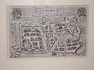
EMVDA / Emden. Kupferstich aus Universus Terrarum Orbis Scriptorum Calamo Delineatus.
Lasor a Varea, Alphonso (d.i Raffaello Savonarola) und Francesco Valegio:
Language: German
Published by Padua: Frambotti & Conzatti,, 1713
- First Edition
- Map
Seller: Antiquariat Hecht, Leer, NDS, GermanyAntiquariat Hecht
Contact seller5-star sellerAssociation member: GIAQ
Condition: Used - Very good
US$ 228.02
US$ 35.39 shippingShips from Germany to U.S.A.Quantity: 1 available
Condition: Gut. Bildgröße ca. 14 x 9,5 cm; Rahmengröße ca. 25,5 x 21 cm; Unter Glas mit Passepartout gerahmt. Sehr guter Zustand. /galerie Sprache: Deutsch Gewicht in Gramm: 2100.

- Map
Seller: Antiquariaat Dat Narrenschip, Middelburg, NetherlandsAntiquariaat Dat Narrenschip
Contact seller5-star sellerCondition: Used - Fine
US$ 117.59
US$ 30.83 shippingShips from Netherlands to U.S.A.Quantity: 1 available
No Binding. Condition: Fine. City map with buildings and houses. Title at the top. Latin text on the back and above and below the print. Etching by Francesco Valegio. Published in 1713 in Padua in "Universus Terrarum Orbis Scriptorum (.)," Alphonso Lasor a Varea. Dimensions (image): 9 x 14 cm.

- Map
Seller: Antiquariaat Dat Narrenschip, Middelburg, NetherlandsAntiquariaat Dat Narrenschip
Contact seller5-star sellerCondition: Used - Fine
US$ 117.59
US$ 30.83 shippingShips from Netherlands to U.S.A.Quantity: 1 available
No Binding. Condition: Fine. Antique map of Great Britain and Ireland. Title above the map. Latin text on the back. Hand-coloured copper engraving, published in Padua in "Universus Terrarum Orbis (.)," Alphonso Lasor à Varea. Dimensions (image): 14 x 18 cm.

- Map
Seller: Antiquariaat Dat Narrenschip, Middelburg, NetherlandsAntiquariaat Dat Narrenschip
Contact seller5-star sellerCondition: Used - Fine
US$ 141.11
US$ 30.83 shippingShips from Netherlands to U.S.A.Quantity: 1 available
No Binding. Condition: Fine. City map of Seville. Title at the top. Latin text on the back, as well as above and below the map. Etching by Francesco Valegio. Published in 1713 in Padua in "Universus Terrarum Orbis Scriptorum (.)," Alphonso Lasor a Varea. Dimensions (image): 9 x 13 cm.

- Map
Seller: Antiquariaat Dat Narrenschip, Middelburg, NetherlandsAntiquariaat Dat Narrenschip
Contact seller5-star sellerCondition: Used - Fine
US$ 188.15
US$ 30.83 shippingShips from Netherlands to U.S.A.Quantity: 1 available
No Binding. Condition: Fine. Antique map of Greece. Title above the map. Verso Latin text. Hand colored copper engraving by Girolamo Porro. Published in 1713 in Padua in "Universus Terrarum Orbis Scriptorum (.)," Alphonso Lasor a Varea. Dimensions (image): 13 x 17 cm.
- Map
Seller: LUX IN ART di Ermanno Bertelli, Bologna, BO, ItalyLUX IN ART di Ermanno Bertelli
Contact seller5-star sellerCondition: Used - Fine
US$ 235.19
US$ 47.95 shippingShips from Italy to U.S.A.Quantity: 1 available
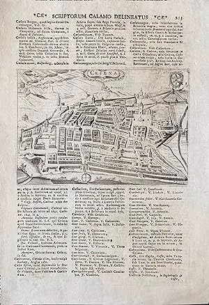
Condition: Ottima. Incisione in rame. Veduta prospettica della città di Cesena. Formato: 124x180 mm (battuta), 319x215 mm (foglio).

- Map
Seller: Antiquariaat Dat Narrenschip, Middelburg, NetherlandsAntiquariaat Dat Narrenschip
Contact seller5-star sellerCondition: Used - Fine
US$ 258.71
US$ 30.83 shippingShips from Netherlands to U.S.A.Quantity: 1 available
No Binding. Condition: Fine. City map of Amsterdam. Title at the top. Latin text on the back. Etching by Francesco Valegio. Published in 1713 in Padua in "Universus Terrarum Orbis Scriptorum (.)," Alphonso Lasor a Varea. Afmetingen (afbeelding): 9 x 13 cm.
- Map
Seller: LUX IN ART di Ermanno Bertelli, Bologna, BO, ItalyLUX IN ART di Ermanno Bertelli
Contact seller5-star sellerCondition: Used - Fine
US$ 282.23
US$ 47.95 shippingShips from Italy to U.S.A.Quantity: 1 available
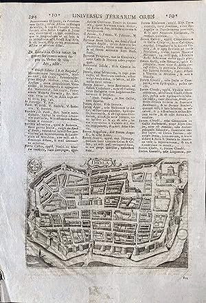
Condition: Ottima. Incisione in rame. Pianta a volo d'uccello della città di Imola facente parte dell'opera "Universus Terrarum Orbi", realizzata dal cartografo Lasor a Varea nel 1713. In alto a sinistra è riportato entro cartiglio la scritta "Imola" e piccolo cartiglio con le chiavi, simbolo dello Stato pontificio. Bella impres…sione, perfetto stato di conservazione. Formato: 218x171 mm (battuta), 317x219 mm (foglio).
- Map
Seller: LUX IN ART di Ermanno Bertelli, Bologna, BO, ItalyLUX IN ART di Ermanno Bertelli
Contact seller5-star sellerCondition: Used - Fine
US$ 305.74
US$ 47.95 shippingShips from Italy to U.S.A.Quantity: 1 available
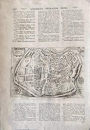
Condition: Ottima. Incisione in rame. Pianta a volo d'uccello della città romagnola facente parte dell'opera "Universus Terrarum Orbi", realizzata dal cartografo Lasor da Varea nel 1713. In alto a sinistra è riportato entro cartiglio la scritta "Forl nella Romagna", in basso a sinistra rosa dei venti e a destra piccolo cartiglio… con chiavi simboleggianti lo Stato della Chiesa. Fascinosissima impressione, perfetto stato di conservazione." Formato: 124x177 mm (battuta), 320x215 mm (foglio).
- Map
Seller: LUX IN ART di Ermanno Bertelli, Bologna, BO, ItalyLUX IN ART di Ermanno Bertelli
Contact seller5-star sellerCondition: Used - Fine
US$ 329.26
US$ 47.95 shippingShips from Italy to U.S.A.Quantity: 1 available
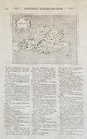
Condition: ottimo. Incisioni in rame. Capillare e raffinata immagine dell'isola di Corsica descritta da Lasor a Varea, la mappa estremamente precisa e dettagliata nonostante le piccole dimensioni, riporta un cartiglio in alto a sinistra con due fregi e una rosa dei venti in basso a destra. è presente un testo al di fuori della b…attuta scritto in latino. Ottimo esemplare molto ben conservato. Formato: 105x140mm.
 More images
- Map
Seller: Altea Antique Maps, London, United KingdomAltea Antique Maps
Contact seller5-star sellerCondition: Used
US$ 469.27
US$ 46.90 shippingShips from United Kingdom to U.S.A.Quantity: 1 available
Padua: Lasor a Varea, 1713. Coloured. 85 x 135mm, set in a larger page of text, overall size 330 x 230 mm. An early plan of Moscow, first published c.1600, based on the Braun & Hogenburg map, with the buildings shown in perspective. On the verso is Magini's map of Russia, also coloured.


