
Order Total (1 Item Items):
Shipping Destination:

Logerot Auguste (11 results)
Skip to main search results
Search filters
Product Type
- All Product Types
- Books (9)
- Magazines & Periodicals (No further results match this refinement)
- Comics (No further results match this refinement)
- Sheet Music (No further results match this refinement)
- Art, Prints & Posters (No further results match this refinement)
- Photographs (No further results match this refinement)
- Maps (1)
- Manuscripts & Paper Collectibles (1)
Condition Learn more
- New (No further results match this refinement)
- As New, Fine or Near Fine (No further results match this refinement)
- Very Good or Good (4)
- Fair or Poor (No further results match this refinement)
- As Described (7)
Binding
- All Bindings
- Hardcover (4)
- Softcover (No further results match this refinement)
Collectible Attributes
- First Edition (1)
- Signed (No further results match this refinement)
- Dust Jacket (No further results match this refinement)
- Seller-Supplied Images (10)
- Not Print on Demand (11)
Language (3)
Price
- Any Price
- Under US$ 25 (No further results match this refinement)
- US$ 25 to US$ 50 (No further results match this refinement)
- Over US$ 50
Free Shipping
- Free Shipping to U.S.A. (No further results match this refinement)
Seller Location
Seller Rating
-

Chateaux, Egliese et Monuments of Paris, anno 1860, 28 Steelengr
Published by Logerot Auguste, Paris
Hardcover. Condition: very good. Chateaux, Egliese et Monuments of Paris, anno 1860, 28 Steelengr Souveniralbum with 28 steelengravings of Paris, size: 10x13 cm., original cloth.
-

Carte de France le Cartes geographiques Tableaux etc. Carte Itin�raire complete de la france indiquant les routes royales avec leur .
Language: German
Published by Atelier de Collage, 1842
Seller: nika-books, Nordwestuckermark-F�rstenwerder, NWUM, Germany
Seller rating 5 out of 5 stars

Karte, Karte auf Leinwand mit leichten Randl�suren, Papier nachgedunkelt, sonst in einem altersentsprechend guten Zustand. Abgleich des Titelbildes bitte bei nika-books. Sprache: Deutsch Gewicht in Gramm: 550.
-
Nouveau plan ou Guide de l'�tranger dans Paris. Ann�e 1850.
Published by Paris, Auguste Logerot, 1850., 1850
Plan de 45 X 62 cm entoil�, divis� en 21 parties, pr�sent� sour �tui de carton marbr�. Index des rues. Contours des 12 arrondissement colori�s � la main. Les monuments sont dessin�s d'apr�s nature par Th�not et grav�s par Duschez. Un des derniers plans de Paris avant les Grands Travaux haussmanniens.
-

ca. 102 x 70 cm, Landkarte. Condition: Gut. Landkarte, �bersichtskarte, Stadtplan, Frankreich, Paris Landkarten, �bersichtskarten 2 S. Sch�ne grenzcolorierte Landkarte / �bersichtskarte; Stadtplan von Paris; Stahlstich von Ch. Dyonnet; mit Stra�en�bersicht und kelinen Detailbildern von Sehensw�rdigkeiten; Geografie / Kartografie / Vermessungskunde; franz�sische Sprache; auf Leinen gezogen; im Schuber; gut erhalten An staatliche Organisationen und Einrichtungen, auch Bibliotheken, versenden wir im Inland gern auf Rechnung. Sprache: Franz�sisch Gewicht in Gramm: 195.
-

US$ 165.26
US$ 23.44 shipping
Ships from United Kingdom to U.S.A.Quantity: 1 available
Add to basketCondition: Good. This volume is undated and untitled and is missing the title page. The author-Logerot- is credited on one of the 29 pages of engravings which are all intact and very remarkable. The title listed is descriptive but replects the engravings which include- Cathedrale de Reims, Vue du Chateau de St Cloud Vue de Chateau Royal de Meudon Illustrations are by the famous Paris map maker Logerot who was working in the second half of the nineteenth century.
-

Plan de Paris et ses fortifications. Dessin� par Maillard, g�ographe. Grav� par Ch. Dyonnet. Les monuments sont dessin�s d'apr�s nature par Th�not, peintre et professeur de perspective, et grav�s par Chamonin
Published by Paris, Auguste Logerot, 1844, 1844
Seller: Librairie Historique F. Teiss�dre, SAUVE, France
Association Member: ILAB
Seller rating 5 out of 5 stars
carte d�pliante de 72 x 102 cm, repli�e au format in-8, contours rehauss�s de couleurs, en feuilles, entoil�es. Tr�s int�ressant plan de Paris nouvellement fortifi� par ce que l'on appellera l'"enceinte de Thiers", laquelle, voulue pour des raisons militaires, continue, m�me d�mantel�e, de limiter au XXIe si�cle l'horizon de la capitale (son trac� a �t� remplac� par celui du P�riph�rique).Augustin-Nicolas, dit Auguste Logerot (1804-1876) a donn� sous la Monarchie de Juillet quantit� de plans de Paris, souvent tr�s proches les uns des autres.Vall�e, 1959 (pour l'�dition de 1845). - - VENTE PAR CORRESPONDANCE UNIQUEMENT - LIEN DE PAIEMENT, NOUS CONSULTER.
-
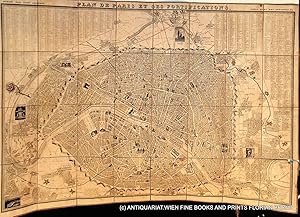
Plan de Paris et ses fortifications.
Published by Paris, 1843
Seller: ANTIQUARIAT.WIEN Fine Books & Prints, Wien, Austria
Seller rating 5 out of 5 stars
Map
Plan de Paris mont� sur lin, ca. 103 x 72 cm, 24 segments; �tat: fortifications colori�es avec la main d'un propri�taire pass�, plusieurs taches sur le verso, entre les segments 16 et 24 s�par�e et segment 24 avec un petit trou, a part ca bon �tat // map of Paris, mounted on linen, ca. 103x72 cm, 24 segments, the fortifications have been coloured by hand by a previous owner, spots on the back of the linen, linen between segments 16 and 24 seperated and segment 24 with a little defect, a part from that good copy Dessin� par Maillard et Toussaint, grav� par Ch. Dyonnet fr 500 Landkarte.
-
Logerot published puzzle '"ATLAS" with six Atlas maps (1870 - 1880)
Published by Auguste Logerot Mid-late 19th century, Paris
Seller: Rare Books Honolulu, Honolulu, HI, U.S.A.
Association Member: IOBA
Seller rating 5 out of 5 stars
Manuscript / Paper Collectible First Edition
n/a. Dyonnet (illustrator). Paris, Publisher: Auguste Logerot, Mid-late 19th century 6 hand-colored lithographed puzzle maps, with hand-colored maps laid down in sections to jigsaw pieces. Text in French. Engraved after Dyonnet's illustrations for A.R. Fremin's Geography. 8�" x 11�" (22x30cm), publisher's box with decorative cover label. All puzzles are complete, even after 130+ years. The only default is a small gap on the top left side of the map of France (see photo). Looks more like a production mistake, as the gap is too small for a missing piece. Jigsaw puzzle maps of the world. Comprises maps of France, Asia, North America, South America, Europe, and Africa. Each map is cut along political boundaries; other versions of the North America map show Mexico as claiming much of the western United States, though this example shows essentially the present-day boundaries. These puzzle maps, popular as educational tools in the 19th century, are rarely found in such good condition. Provenance: The Warren Heckrotte and Margaret Gee Collection. Condition: Case worn with some splits at edges; some pieces bent, some minor losses to image, minor wear and toning; very good in good box. Logerot edited maps from renowned cartographers such as Fremin, Dufour, Dyonnet, Delamarche and Vuillemin, crafting a collection that comprised maps, atlases, folding case maps, and intricate jigsaw puzzle maps. Logerot and Fremin collaborated on various atlases, with one of their editions serving as the foundation for this collection. The maps, such as the one depicting Africa, reflect the geographic knowledge of the time, dating back to 1829 . Notably, the map of the United States not included Texas, California, and New Mexico as part of Mexico, as these regions were still in dispute before 1846. There is still a part of California claimed by the English Crown as New Albion.
-

Carte de la Normandie - Carte de la Normandie - Seine Inf�rieure - Logerot 185
Language: French
Seller: Librairie AMB, SAINT-OUEN-SUR-SEINE, STOUE, France
Seller rating 5 out of 5 stars
Feuille. Condition: Bon Etat. Physique Carte de la Normandie comprenant les d�partements de la Seine Inf�rieure, de la manche, du Calvados, de Leur et de Lorne.En haut, � gauche : armes de la province de NormandieFormat : 73x59 cm - 16x10 cm. Belle carte rempli�e sous cartonnage d�tach�. propre, deux petites fentes sur bordure.Non entoil�e. bel �tatParis par Auguste Logerot (1804-1876) 55 Quai des Grands Augustin"Occasion" 0g.
-
Paris illustr� et ses fortifications. Paris divis� en 20 arrondissements pour 1862.
Seller: Libreria Oreste Gozzini snc, Firenze, FI, Italy
Seller rating 5 out of 5 stars
Paris, 1862, pianta della citt� in litografia, con arrondissements colorati, mm. 570x745, intelata a sezioni e ripiegata entro custodia in cartoncino marmorizzato. Buone condizioni.
-

Nouveau plan de Paris divise en 20 arrondissements. Dans un rayon de 10 kilometres.
Publication Date: 1863
Seller: Henry Sotheran Ltd, London, United Kingdom
Association Member: ABA ILAB PBFA
Seller rating 5 out of 5 stars
US$ 413.16
US$ 53.48 shipping
Ships from United Kingdom to U.S.A.Quantity: 1 available
Add to basketParis: Le plan par Ch. Smith, Mangeron for Logerot. 1863. Folding linen-backed lithographic map with hand-colouring, measuring 71 by 104 cm; evenly a little darkened; printed label on the verso of the first panel.


