Order Total (1 Item Items):
Shipping Destination:

Low Countries (21 results)
Skip to main search results
Search filters
Product Type
- All Product Types
- Books (16)
- Magazines & Periodicals (1)
- Comics (No further results match this refinement)
- Sheet Music (No further results match this refinement)
- Art, Prints & Posters (1)
- Photographs (No further results match this refinement)
- Maps (2)
- Manuscripts & Paper Collectibles (1)
Condition Learn more
- New (3)
- As New, Fine or Near Fine (4)
- Very Good or Good (6)
- Fair or Poor (No further results match this refinement)
- As Described (8)
Binding
Collectible Attributes
- First Edition (4)
- Signed (No further results match this refinement)
- Dust Jacket (No further results match this refinement)
- Seller-Supplied Images (11)
- Not Print on Demand (21)
Language (2)
Free Shipping
Seller Location
Seller Rating
-

The Spectator Friday, April 22, 1949 / Wilson Harris "Rumours From Russia" / Peter Townsend "400,000,000 Farmers" / D W Brogan "In The Low Countries" / R A Voigt !Makronesos" / Edward Montgomery "America Faces The Cost" / Brigadier G S Brunskill "African Transport (Colonial Prospect)" / Peter Fleming "Stratford, 1949"
Published by The Spectator Ltd,, 1949
Magazine / Periodical
US$ 20.66
US$ 14.71 shipping
Ships from United Kingdom to U.S.A.Quantity: 1 available
Add to basketSoft cover. Condition: Very Good. 32 pages. Wilson Harris "Rumours From Russia" / Peter Townsend "400,000,000 Farmers" / D W Brogan "In The Low Countries" / R A Voigt !Makronesos" / Edward Montgomery "America Faces The Cost" / Brigadier G S Brunskill "African Transport (Colonial Prospect)" / Peter Fleming "Stratford, 1949" (Papers).
-

Condition: Brand New. New. US edition. Expediting shipping for all USA and Europe orders excluding PO Box. Excellent Customer Service.
-

The Low - Income Countries of the Commonwealth of Independent States. Progress and Challenges in Transition.
Language: English
Published by Washington: World Bank, 2004
ISBN 10: 158906321X ISBN 13: 9781589063211
Seller: Plurabelle Books Ltd, Cambridge, United Kingdom
Association Member: GIAQ
Seller rating 5 out of 5 stars

First Edition
US$ 46.83
US$ 10.70 shipping
Ships from United Kingdom to U.S.A.Quantity: 1 available
Add to basketPaperback. Condition: As New. Grey paperback with green lettering to cover and spine, as new, shrink wrapped therefore untouched, excellent copy Language: English.
-

MANUSCRITS ET LIVRES IMPRIMES CONCERNANT L'HISTOIRE DES PAYS-BAS 1475-1600
Publication Date: 1962
Seller: Xerxes Fine and Rare Books and Documents, Glen Head, NY, U.S.A.
Seller rating 5 out of 5 stars
Condition: Near Fine. Bruxelles 1962. Bibliotheque Nationale d'Autriche. In French. Large octavo, 111pp., full page monochrome plates, original illustrated wraps. Near Fine, light toning on cover. no owner marks. internally fine.
-
-

The drama of the low countries herman-balthazar
Language: English
Published by Fonds Mercator Paribas, 1996
ISBN 10: 9061533740 ISBN 13: 9789061533740
Condition: New.
-

General & Statistical Map of Belgium and the Netherlands. (18 miles to the inch)
Published by 1881.17.25 x 14in (44 x 36cm), 1881
Seller: R.G. Watkins Books and Prints, Ilminster, SOMER, United Kingdom
Seller rating 5 out of 5 stars
Map
No Binding. Condition: Very good. Colour map, from Letts's "Popular Atlas", showing railways, roads, canals, and boundaries. central fold, few nicks on edges of fold, crease to part of map,
-
Low Income Countries Of The Commonwealth Of Independent Countries: Progress And Challenges In Transition
Language: English
Published by International Monetary Fund (IMF)
ISBN 10: 158906321X ISBN 13: 9781589063211
Condition: Sehr gut. Zustand: Sehr gut | Seiten: 306 | Sprache: Englisch | Produktart: B�cher | Keine Beschreibung verf�gbar.
-
MAP OF THE LOW COUNTRIES, OR NETHERLANDS - Original Antique Map, Printed circa 1723
Language: English
Publication Date: 1723
Seller: K Books Ltd ABA ILAB, York, YORKS, United Kingdom
Association Member: ABA ILAB PBFA
Seller rating 5 out of 5 stars
US$ 68.86
US$ 26.07 shipping
Ships from United Kingdom to U.S.A.Quantity: 1 available
Add to basketNo Binding. Condition: Very Good. Moll (illustrator). Original antique hand-coloured map, colouring not contemporary, but delicately and expertly done. Mounted (matted) and ready to frame. Map of the Netherlands in General, showing Flanders or the Spainish Netherlands, with the Archbishoprick of Cambresis and Bishoprick of Lyege etc, compass top left, printed c1723.
-
Illuminated Manuscript Leaf from a Book of Hours in Middle Dutch
Language: English
Published by Low Countries, 1480
Seller: Books & Bidders, Cleveland, OH, U.S.A.
Association Member: IOBA
Seller rating 5 out of 5 stars
Manuscript / Paper Collectible
No Binding. Condition: Fine. Vellum leaf, 187 x 132 mm, 20 lines in Gothic textura script. A superb illuminated leaf from a Book of Hours produced in the Low Countries during the late 15th century, a period when the workshops of Bruges, Ghent, and Utrecht were creating some of Europe's most exquisite devotional manuscripts. The text written in a fine dark Gothic textura hand, is in Middle Dutch, and forms part of a prayer to the Virgin Mary, most likely from the Hours of the Virgin or Suffrages. The opening words, "Naudige vrouwe dijns heeren soens verdiente te worde." (Gracious Lady, though the merits of your Son."), speak with intimate devotion in the vernacular tongue, offering a poignet glimpse into private medieval piety. The leaf is richely adorned with a large historiated initial "D" painted in burnished gold and lapis blue enclosing a minature of a dragon, set within a field of gilt tracery. A full bar border extends along the left margin, with radiant sprays of acanthus leaves, curling tendrils, and seed pods in blue, green, rose and gold, a classic feature of Flemish illumination. Red rubrics and alternating red and blue intials punctuate the text. On vellum of fine quality, the surface smooth and well-preserved. Ink remains crisp and legible, gold retains a soft brilliance. Minor toning and of few small age spots at the outer margins, faint cockling along edge. No tears or losses. Middle Dutch Books of Hours are scarcer on the market than their Latin counterparts, and leaves with complete borders and historiated intials are particuly desirable. Overall, a beautifully preserved and highly decorative leaf, suitable for display. Unmatted and unframed.
-
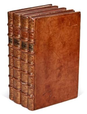
Le grand th�atre profane (-- sacr�) du duch� de Brabant
Published by Chr�tien van Lom; Gerard Block, 1730
Seller: Arader Galleries - AraderNYC, New York, NY, U.S.A.
Seller rating 5 out of 5 stars
First Edition
Hardcover. Condition: Very Good. 1st Edition. Two works in four volumes. First edition in French (profane), second edition in French (sacr�). The Hague: Chr�tien van Lom; Gerard Block, 1730, 1734. Folio (480mm x 292mm). Profane: with 4 engraved plates of arms, one plate of coins and 188 views and plans on 67 sheets. Sacr�: with 2 double-page maps, five in-text engravings and 271 engraved plates (21 portraits; the others views, plans, buildings, altars and memorials), of which 74 are double-page. Bound in contemporary polished calf. Rubbed generally, with wear at the joints. A set of two separately-issued but obviously complementary works on the secular and ecclesiastical architecture of the Duchy of Brabant. At the time of printing, Brabant was divided between the Dutch Republic in the north and the Austrian Habsburg Empire in the South; today, all of the territory except the Dutch province of North Brabant is part of Belgium. The "Profane" engravings include plans and panoramic views of cities and towns, while the "Sacr�" volumes, first issued in 1729, show not only church and monastic architecture, but details of tombs, memorial plaques, and epitaphs, along with portraits of the bishops of the dioceses of the duchy. The engravings have the crystalline purity of line that set apart the topographical works of Merian a century or so earlier. Many copies of these works were broken up into individual plates, making complete sets of both works in contemporary bindings, as here, especially desirable. Brunet II, 1699.
-
Belgium or the Netherlands : hand coloured. A finely detailed map from John Thomsons New General Atlas, 1817.
Published by John Thomson & Co, Edinburgh, 1817
US$ 103.84
US$ 15.91 shipping
Ships from United Kingdom to U.S.A.Quantity: 1 available
Add to basketUnframed Print. Condition: Very Good. Drawn and engraved expressly for John Thomsons celebrated New General Atlas, this hand-coloured map delineates the Napoleonic-era division of the Low Countries into 13 French departments. It highlights administrative centres such as Brussels, Ghent, and Coblentz, with geographic referencing to Greenwich meridian, reflecting British cartographic conventions. The map offers a rare visual record of early 19th-century territorial organisation prior to Belgian independence. Engraving 48 x 61 cms, sheet 64 x 68 cms. Very crisp and clean, centre folded as issued. No foxing or browning, no tears. A very attractive example. Category: PRINTS : Antiquarian Interest; PRINTS : Historic Interest; Special Interest. This item may require more postage than the rates shown for delivery outside the UK. If extra postage is required we will contact you before processing your order and you will be given the details and option to decline the extra cost. Cosmo Books : 29 years on ABE, 47 years taking care of customers. A bookseller you can rely on.
-
Tijdschrift van de Koninklijke Vereniging voor Nederlandse Muziek Geschiedenis. Volume LIII issue 1/2 ( 2003 ).
Seller: Antiquariaat Wim de Goeij, Kalmthout, ANTW, Belgium
Association Member: ILAB
Seller rating 5 out of 5 stars
Utrecht, V.N.M. (Koninklijke Vereniging voor Nederlandse Muziek Geschiedenis), 2003, in-8�, complete issue , as published (317 pp. softcover. Contains 7 studies on medieaval and Renaissance liturgy and chant in the Northern Netherlands (diocese of Utrecht). Among the authors: Leslie Locket, Lori Kruckenberg, Alexander Blachly, Rob Duckers, Gisela Geritsen .
-
Arrest du conseil d' estat du roy, qui fixe l entr�e dans le royaume des bas & autres ouvrages de Bonneteries estrangeres, composez de laine, par les ports de Calais & Saint Vallery.
Published by Imprimerie Royale, 1720
Seller: H�nersdorff Rare Books ABA ILAB, London, United Kingdom
Seller rating 3 out of 5 stars

First Edition
US$ 344.30
US$ 30.08 shipping
Ships from United Kingdom to U.S.A.Quantity: 1 available
Add to basketNo Binding. Condition: Very Good. 1st Edition. Regency for King Louis xv. Arrest du conseil d estat du roy, qui fixe l entr�e dans le royaume des bas & autres ouvrages de Bonneteries estrangeres, composez de laine, par les ports de Calais & Saint Vallery. Du 3.May 1720. Paris, De l Imprimerie royale, 1720. 4to. 4 pages. Large ornamental vignette above drop-title. Untrimmed, as issued. Regency edict passed during the minority of Louis xv restricting the importation of foreign produced wool and silk bonnets and other draperies from the Low Countries to the sea ports of Calais and St Valery-sur-Somme in accordance with tariffs introduced on 18 April 1667 on pain of confiscation of the merchandize if brought into France by road.
-
Holland - with Vignette of Rotterdam and Depictions of Dutch Peasants on the Dort.
Published by London & New York, J & F. Tallis., 1851
Seller: Inanna Rare Books Ltd., Skibbereen, CORK, Ireland
Seller rating 5 out of 5 stars
Art / Print / Poster
Original steel engraving / Vintage map. Drawn and engraved by John Rapkin. Partly hand-coloured. Illustrations by H. Warren and engravings by J.B. Allen. Plate Size: 25 cm x 35 cm. Sheet Size: 27.2 cm x 37.3 cm. Vintage 19th century map in very good condition. Published in the Illustrated Atlas, And Modern History Of The World Geographical, Political, Commercial & Statistical, Edited By R. Montgomery Martin. Beautiful and interesting map of Holland. The internal political sub-divisions are shown on the map, with provinces such as Gelderland, North Brabant and Groningen identified. The Netherlands are surrounded by Belgium to south and the German states of Prussia and Hanover to the east with The North Sea lapping against the Dutch in the west. The map is crowded with towns and cities such as Amsterdam, Eyndhoven that illustrate the urban and densely populated status of Holland. The railway system is included on the map also. Relief is depicted by hachuring. The rivers and lakes such as the Haarlem Meer and River Wall are also included. The Zuyder Zee can also be seen. John Tallis (7 November 1817 3 June 1876) was an English cartographic publisher. His company, John Tallis and Company, published views, maps and atlases in London from roughly 1838 to 1851. Tallis set up as a publisher with Frederick Tallis in Cripplegate in 1842; the business moved to Smithfield in 1846, and was dissolved in 1849. From 1851 to 1854 Tallis operated as John Tallis and Company. He started The illustrated news of the world and national portrait gallery of eminent personages in 1858, selling it for �1,370 in 1861; it folded in 1863. (Wikipedia) The most important project John Tallis undertook, was the 'Illustrated Atlas' from 1851. The original map we offer here, was part of this exceptional Atlas and all the maps it contained are still today considered as the last reminder of an era of lavish map production. Tallis worked the project together with John Rapkin (1815-1876) and it was Rapkin's style and talent that we have to thank for when we marvel at these maps today. What makes these maps so special is the detail of engraved vignettes that surround the map and often show indigenous scenes, people in their environment and even more so, historical buildings or historical views of towns and cities, architecture and landscape. The project of 'The Illustrated Atlas' was designed to be finished just in time for the anxiously awaited "Great Exhibition of the Works of Industry of All Nations" or The Great Exhibition, sometimes referred to as the Crystal Palace Exhibition in reference to the temporary structure in which it was held, was an international exhibition that took place in Hyde Park, London, from 1 May to 11 October 1851. It was the first in a series of World's Fairs, exhibitions of culture and industry that became popular in the 19th century, and it was a much-anticipated event. The Great Exhibition was organized by Henry Cole and Prince Albert, husband of the reigning monarch, Queen Victoria. It was attended by numerous notable figures of the time, including Charles Darwin, Samuel Colt, members of the Orl�anist Royal Family and the writers Charlotte Bront�, Charles Dickens, Lewis Carroll, George Eliot and Alfred Tennyson. Music for the opening was under the direction of Sir George Thomas Smart and the continuous music from the exhibited organs for the Queen's procession was "under the superintendence of William Sterndale Bennett". (Wikipedia) Sprache: english.
-
Het avantuurlyk zomer-tochtje, of omlands reisje, uit Holland door 't Sticht Utrecht, Over-Yssel, Gelderland, Cleeffland, de Myery van den Bosch, Breda, enz. Behelzende eenige nauwkeurige beschryvinge van vele aardige gevallen, vermakelyke gesprekken en aangename historien, op die reize gebeurt of gehoort. Opgestelt door iemand welke dat tochtje zelf met gezelschap gedaan heeft.
Published by printed for the author,, [Amsterdam?],, 1735
Seller: Antiquariaat FORUM BV, Houten, Netherlands
Seller rating 5 out of 5 stars
First Edition
US$ 2,079.07
US$ 28.84 shipping
Ships from Netherlands to U.S.A.Quantity: 1 available
Add to basketRare second edition of a popular travel account of a summer holiday trip through the Netherlands and Cleve. Travelling from the Hague, they visited Utrecht, Leiden, Zeist, Soestdijk, Amersfoort, Voorthuizen, Deventer, Doesburg, Middachten, Rozendaal, Arnhem, Elterberg, Emmerik, Kleef, Nijmegen, Grave, Hees, Den Bosch, Tilburg, Dongen, Breda, Waalwijk, Gorcum, Vianen, Schoonhoven, and various country estates along the way, such as 't Loo, Huis Heemstede, and Huis te Voorst. The travelling was done by public means of transport, by barge, by coach, and on foot. Other than the various day trips, the work also includes the stories the travellers told each other en route, of which many are somewhat erotic in nature.The author remained anonymous by his own request. He was persuaded by his friend and travel companion to publish the account of their travels, but requested that the people and names mentioned would be erased, for it was initially only written for himself and good friends, but now "for the whole world to see". The first edition was published in 1734 by J. Loveringh. The present second edition, however, is rarer, with only one institutional copy recorded in the Dutch Short Title Catalogue (STCN).The work has been recased, with new end papers, the binding has been professionally restored at the upper corner of the front board and the head of the spine. A faint water stain in the outer margin of the first few leaves, not affecting any text. Otherwise in good condition.l Scheepers II, 248; STCN 240053419 (1 copy); Waller 1911; cf. Buisman 2559 (other ed.); Muller 885 (other ed.). Contemporary vellum, with the manuscript title on the spine, blue sprinkled edges. With a woodcut vignette on the title-page, 2 decorated woodcut initials, and a woodcut tailpiece. Pages: [8], 439 pp.
-
Plan du campement de l'arm�e des alliees camp�e a Corbay depuis le 19 Juin au 7 Juliet l'an 1696.
Published by [Belgium?,, 1696
Seller: ASHER Rare Books, T Goy Houten, Netherlands
Seller rating 5 out of 5 stars
US$ 2,376.08
US$ 28.84 shipping
Ships from Netherlands to U.S.A.Quantity: 1 available
Add to basketContemporary manuscript plan of the camps of the allied troops fighting against France during the Nine Years' War, in the vicinity of Korbeek (Corbais), near Waver, Belgium, between 19 June and 7 July 1696. These troops were part of the Grand Alliance, the European-wide coalition that fought against Louis XIV during the Nine Years' War (1688-1697). The present map shows mostly Dutch and German, but also Spanish troops. The Dutch forces include troops led by well-known commanders as Menno van Coehoorn, Johan van Baer van Slangenburg and Lodewijk Crato van Nassau-Saarbr�cken.The map is drawn on paper watermarked: fleur-de-lis on a crowned shield above WR = IHS DC (?), similar watermarks all date from the last decades of the 17th-century (cf. Heawood 1780, 1785 and 1787).A few minor tears along the edges and some brown water stains. Nevertheless, the plan remains clearly legible and the colouring remains bright. Manuscript plan on paper (38 x 48 cm) in ink and bright watercolour. With the title in a wreath at the head, a large panel at the foot with keys identifying the camps of the various troops, and two smaller panels at the head, with keys to the villages and other locations, and a general overview map.
-
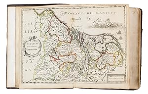
La description de XVII. Provinces, avec les Terres Circonvoicins, a Scavoir Champagnie, Picardie, Liege, Retelle, &c.
Published by Jan Huyssens,, Antwerp,, 1652
Seller: ASHER Rare Books, T Goy Houten, Netherlands
Seller rating 5 out of 5 stars
US$ 5,880.81
US$ 28.84 shipping
Ships from Netherlands to U.S.A.Quantity: 1 available
Add to basketSecond known copy of a pocket-atlas, published at Antwerp but containing a selection of the maps of the Low Countries originally published by Jacob Aertsz. Colom at Amsterdam in 1635 with the title De Vyerighe Colom, the title Colom had first used for his famous pilot guide in 1632, and the name he had given to his Amsterdam printing office, where he worked from 1622 to his death in 1673 as a bookseller, printer and mapmaker. The only other copy known is at the Royal Library in Brussels. The Vyerighe Colom, with 47 maps and 3 plates, and with extensive text in Dutch and French, went through several editions in the 17th century, but it was once thought that all editions before his death in 1673 had been published at Amsterdam by Colom himself. The Royal Library copy, like the present one, contains 39 maps, but each contains one map not in the other, so there are forty in total: the present copy includes "Drentiae", not in the Royal Library copy, which includes "Le terres entre la Meuse Vahal et Rhin", not present here. The maps are also bound in a different order.The present edition is of great interest and gives cause to review Colom's activities. It is printed from Colom's plates, so Colom may have licenced the Antwerp publisher to produce a variant edition of his Vyerighe Colom to broaden his market, possibly reacting to the signing of the Peace of M�nster in 1648, which finally ended the Eighty Years' War and opened trade and communication between the northern and southern Low Countries. Jan Huyssens made an entirely new and practical atlas out of Colom's Vyerighe Colom. He omitted all text and the three plates that do not show maps, and selected only maps of general interest, leaving out the map of the ancient Low Countries and such typical Dutch maps as the separate maps of the polders De Zype, Beemster, Wormer, Purmer, Byllemermeer and Waterland, also - at least in the present copy - completely rearranging the maps, more in order of their geographical sequence. The title suggests that Huyssens originally planned to include a text, so the present extremely rare edition may be the only surviving result of an abandoned project.l Koeman & Van der Krogt 365.23 (IIIB, pp. 644-645) (2 copies: the present & Royal Library Brussels); UniCat 99095764 (Royal Library Brussels only); cf. Koeman II, Col 1 (1635 Amsterdam ed.); not in KVK; STCV; WorldCat. Later 17th-century mottled calf, sewn on 4 double cords, gold-tooled spine and board edges. With a double-page letterpress title-page, with a frame built up from typographic ornaments, and 39 unnumbered double-page engraved maps of the northern and southern Low Countries by Jacob Aertsz. Colom, each map coloured in outline. Interleaved with 38 blank leaves and with a manuscript table of contents ([3], [3 blank] pp.) at the end. Pages: Double-page title-page and 39 double-page maps.
-
Alosti in Flandria anno M�CCCC�LXXIII. Facsimile.
Seller: Antiquariaat Wim de Goeij, Kalmthout, ANTW, Belgium
Association Member: ILAB
Seller rating 5 out of 5 stars
2. Brussels, Royal Library, 1973, 4 vols. in-8�, sewn, orig. wrapper, in publisher's slipcase, 21 x 14,5 cm, 114 pp ; (52) pp ; (48) pp ; (52) pp. Reprint of the first three incunabels printed in the Low Countries by D.Martens: D.van Rijkel: Speculum conversionis peccatorum; Pseudo aspiratione animae ad deum. Aeneas Silvius Piccolomini: De duobus amantibus. With a commentary volume by K.Heireman s.j. (in Dutch, French, German & English). Spines with some slight water stains but still a fine set.
-

Benelux Carte touristique de la Belgique, de la Hollande et du Luxembourg Tourist map of Belgium, Holland and Luxermburg Mapa turistico de Belgica, Holanda y Luxemburgo Mapa turistico da Belgica, Holanda e Luxemburgo.
Publication Date: 1958
Seller: Geographicus Rare Antique Maps, Brooklyn, NY, U.S.A.
Association Member: ABAA ESA ILAB
Seller rating 4 out of 5 stars

Map
Good. Infill to upper left corner. Several small tears along right border professionally repaired. Size 22.5 x 34.5 Inches. This is a c. 1958 pictorial map of the Low Countries or Benelux countries, produced by Libra Studio and printed in Holland by Kuhn en Zoon. A Closer Look Coverage includes the countries of Belgium, the Netherlands, and Luxembourg. Cities, towns, and islands are labeled and depicted with illustrations of local culture and architecture. The names of many Belgian cities are rendered in Dutch (e.g., 'Antwerpen,' 'Gent'), a reflection of the makers' location in Holland, even though the title and other information are in French, English, Spanish, and Portuguese. In addition to churches, castles, and figures engaging in leisure activities, several military cemeteries are noted, a grim reminder of World War II (1939 - 1945) despite the work's overall festive tone. Illustrations and text surrounding the map offer information on recreational activities and cultural institutions. Illustrations of airplanes are accompanied by information on flight times to major European and American cities. Publication History and Census This map is generally attributed to Libra Studio and is noted as having been printed in Holland by Kuhn en Zoon. It is undated, but from certain details, such as the illustrations of airplanes (propeller planes instead of jets) and the flight times given, it most likely dates from the 1950s. It may have been produced to coincide with the 1958 World's Fair (Expo '58) in Brussels. This map occasionally appears on the market but is scarce in institutional collections, only being noted in the OCLC at the Utrecht University Library. The David Rumsey Historical Map Collection holds an alternate printing (dated circa 1975, which we consider too late) issued for Pan American World Airways. References: OCLC 1013533800. Rumsey 15031.000 (alternate printing).
-
Le Theatre De La Guerre, Dans Les Pays-Bas, Ou Representation Des Principales Villes qui sont en Flandres, Hainaut, Brabant, &c. Avec Leurs Fortifications; Dessignees par les meilleurs Ingenieurs de ce temps (.). Premier - Deuxieme Volume. [Part I - II, complete].
Seller: Fahrenheit 451 Antiquarian Booksellers, Nieuwerbrug, Netherlands
Seller rating 4 out of 5 stars
US$ 2,673.09
US$ 41.52 shipping
Ships from Netherlands to U.S.A.Quantity: 1 available
Add to basket"A Paris, Chez l'Auteur (.)".