
Order Total (1 Item Items):
Shipping Destination:

Manuscript Map (106 results)
Skip to main search results
Search filters
Product Type
- All Product Types
- Books (19)
- Magazines & Periodicals (No further results match this refinement)
- Comics (No further results match this refinement)
- Sheet Music (No further results match this refinement)
- Art, Prints & Posters (No further results match this refinement)
- Photographs (No further results match this refinement)
- Maps (87)
- Manuscripts & Paper Collectibles (No further results match this refinement)
Condition Learn more
- New (No further results match this refinement)
- As New, Fine or Near Fine (1)
- Very Good or Good (5)
- Fair or Poor (No further results match this refinement)
- As Described (100)
Binding
Collectible Attributes
- First Edition (2)
- Signed (4)
- Dust Jacket (No further results match this refinement)
- Seller-Supplied Images (100)
- Not Print on Demand (106)
Language (2)
Free Shipping
Seller Location
Seller Rating
-
The Astrology of I Ching
Language: English
Published by Routledge & Kegan Paul, London, 1979
ISBN 10: 0710002580 ISBN 13: 9780710002587
Seller: Babushka Books & Framers, Isle of Wight, United Kingdom
Seller rating 4 out of 5 stars

US$ 18.00
US$ 22.99 shipping
Ships from United Kingdom to U.S.A.Quantity: 1 available
Add to basketSoft Cover. Condition: Good. Reprint.
-

The Prehistory of Salts Cave, Kentucky: Reports of Investigations, No.16
Published by Illinois State Museum - reports of investigations No. 16, Springfield IL, 1969
First Edition
stiff paper covers. Condition: very good. Figure 3: Map of a Portion of Salts Cave adapted from manuscript maps on file with Cave Research Foundation, 464 M. Street SW, Washington D.C/.22024 (illustrator). First Edition. With fold-up map 17 1/2 x 20", b/w map of a Portion of Salts Cave (adapted from manuscript maps on file with Cave Research Foundation, Washington DC, 2024). Analyses of the prehistoric cultural remains in Salts Cave, mineralogy of the Salts Cave Archaeological Site by Wiliiam B. White. small previous owner's name at upper inner corner of front cover. label inked out on front cover,
-

Copy of a Manuscript Tract addressed to Lord Burghley, illustrative of the Border Topography of Scotland, A.D. 1590; with a Platt or Map of the Borders taken in the same Year, both preserved in one of the Royal MSS. in the British Museum. An article printed in 1829, written by Henry Ellis : 11 pages + 1 large plate.
Published by Archaeologia, or Miscellaneous Tracts relating to Antiquity., London, 1829
US$ 27.01
US$ 16.00 shipping
Ships from United Kingdom to U.S.A.Quantity: 1 available
Add to basketBooklet - Unbound Pages. Condition: Very Good. 11 pages + 1 large plate. An authentic standalone article, extracted from a larger volume of Archaeologia, Miscellaneous Tracts relating to Antiquity. Not a reprint or reproduction, but an original work in its own right. Preserved in a modern card cover, prepared for practicality - an unassuming but serviceable presentation that favours function over finery. Size: 25 x 30 cms. Category: Archaeologia; Cosmo Books : 29 years on ABE, 47 years taking care of customers. A bookseller you can rely on.
-
HISTORICAL NOTES WITH KEYED MAP OF KEENE AND ROXBURY CHESHIRE COUNTY, NEW HAMPSHIRE FROM A MANUSCRIPT BY SAMUEL WADSWORTH
Published by Sentinel Printing Co., Keene, NH, 1932
Seller: Ray Boas, Bookseller - Established 1980, Walpole, NH, U.S.A.
Seller rating 5 out of 5 stars

HC. fold-out map in pocket (illustrator). Text is keyed to locations on the large fold-out map - a single map as called for. very good, blue cloth (hardcover).
-
Nivellirnyi plan goroda Tiflisa sostavlennyi po trianguliatsii, semke i invellirovke goroda v 1879-1881 gg. inzhenerami putei soobshcheniia S. Umanskim, A. Popovy, i P. Zamiatninym. [Plan of the City of Tiflis compiled by the Engineers S. Umanskiy, A. Popov and P. Zamiatnin].
Published by - 1881, 1879
Seller: Shapero Rare Books, London, United Kingdom
Association Member: ABA ILAB PBFA
Seller rating 5 out of 5 stars
Map
US$ 17,310.02
US$ 20.17 shipping
Ships from United Kingdom to U.S.A.Quantity: 1 available
Add to basketSquare folio, 600 by 600mm (23½ by 23½ inches), 42 sheets, including 34 larger and 8 smaller sheets (40 with contemporary hand colour; 2 �" B&W); some light soiling. Contemporary calf over brown cloth, gilt lettering to upper cover; slightly rubbed, corners bumped. A large manuscript topographic map of the Georgian capital Tbilisi. The Caucasus Topographical Bureau was established in 1853, and yet active mapping of the region began only after 1866, when Iyeronim Stebnitskiy (1832-1897) was appointed head of the Bureau. Work in the region was first undertaken in the northern Caucasus before progressing to the south. The agency's efforts were interrupted by the Russo-Turkish War in 1877 �" 1878, when most of its employees were relocated to the basin of the Black Sea, charged with the task of researching the territories newly occupied by the Russian army. � The plan offered here was produced following the end of the war, when the Bureau was able to return to its routine work. It is drawn on 42 sheets to a scale of 1:2000 and shows the whole city of Tiflis (now Tbilisi), centering on the Mt'k'vari River, with all the topographical details, including the relief, streets and buildings. The sheets are numbered with corresponding rows and columns so that they can be assembled into a single, large wall map. This manuscript plan is almost identical to the "Plan of the City of Tiflis with Surroundings" published by Il'in in Saint-Petersburg in 1887 and was likely used as the basis for this later work. Russian manuscript plans of this scale and quality are very rare, especially in good condition and largely complete, as here. Produced for official use, the majority of them remained in state archives and libraries. � Istoricheskiy ocherk deyatelnosti korpusa voennykh topografov v [�] v 1855 �" 1880 gg. (Skt. Peterburg, 1880), p.74.
-
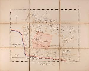
A folding map of Beshagard in south-eastern Persia, containing coastlines of Persian Gulf and the Gulf of Oman. Commissioned by Suleyman Mirza for the Royal Armoury.
Published by Qajar Persia AH 1893-94 AD, 1311
Seller: Shapero Rare Books, London, United Kingdom
Association Member: ABA ILAB PBFA
Seller rating 5 out of 5 stars
US$ 2,423.40
US$ 20.17 shipping
Ships from United Kingdom to U.S.A.Quantity: 1 available
Add to basketA single folding manuscript map of Beshagard in south-eastern Persia, copied by 'Sulayman Qajar' and hand-coloured, copied on 6 sheets and linen-backed, total 475 by 605 mm; with two marbled paper wrappers pasted over board sections (forming covers when folded), paper label to upper cover, extremities a little rubbed, internally bright and attractive. A label pasted to the front wrapper reads 'Map of Beshagard, the work of Sulayman Mirza', and the map itself is entitled 'The work of the servant of the court Sulayman Qajar, the colonel of the August Armoury, 1311 AH' (1893-94 AD)'. Suleyman Mirza has not been identified.
-
US$ 1,177.08
US$ 47.06 shipping
Ships from United Kingdom to U.S.A.Quantity: 1 available
Add to basketNo Binding. Condition: Very Good. Manuscript map of Palestine, ink drawn on cream vellum measuring 56.5 x 45 cm, slightly soiled, 9 x 10 cm vignette top right corner showing road to Damascus from Sa'sa', c 1915. The map shows the coast from Rafah in the South to Sour and Qunaitra in the North East, and the city of Amman to the east. #32877.
-
Fein gemalte, aquarellierte Zeichnung einer Festung aus der Vogelschau, wohl Saint Venant in Nordost-Frankreich.
Published by Frankreich?, um 1720., 1720
circa 20 x 23 cm. 1 Blatt verso weiss "Aquarell �ber Tusche auf festem Papier in Schwarz, Rosa und verschiedenen Gr�nt�nen. Unten rechts alt als "St. Venant" bezeichnet. Im Spanischen Erbfolgekrieg fand 1710 eine Belagerung von Saint-Venant statt. " - Sauber, dekorativ.
-
![Seller image for ?? ?? [Ouzhou ditu]. [Map of Europe]. for sale by Asia Bookroom ANZAAB/ILAB](https://pictures.abebooks.com/inventory/md/md32452675673.jpg)
?? ?? [Ouzhou ditu]. [Map of Europe].
Published by (Mid - Late 20th Century)., [China].
Seller: Asia Bookroom ANZAAB/ILAB, Canberra, ACT, Australia
Association Member: ANZAAB ILAB
Seller rating 5 out of 5 stars
Large handpainted folding political map of Europe including some geographical features, surrounding seas painted in blue, labelled in manuscript simplified Chinese characters, 78.5 x 109cm. Some small holes at fold points, small paper repair on reverse at lower margin, in very good condition. Appears to have been painted by a teacher in China for use as a large classroom map illustrating the political situation and borders in Europe after the Second World War. Major geographical features, including mountain ranges, are used to demarcate a number of countries, and the Danube and Volga rivers are shown. An interesting example of mid - late twentieth-century Chinese classroom teaching material.
-
Large map in ink and watercolour. Mappa dimostrante l ubicazione della cava della terra marna esistente nel podere detto il Poggio in collecchio appartenente alli Sigr. Marchesi Ercole e Lodovico Bergonzi estesa das Sigr. Perito Besmetra e sotto Ispettore del patrimonio dello stato Sigr. Francesco Pellegrini.
Published by Parma, 3 maggio, 1823., 1823
folded circa 31 x 21 cm. 1 large map, circa 52,5 x 79,5 cm Decorated wrapper with large label to front cover Detailed map of an estate near Parma, property of the Marquesses Bergonzi, probably at the occasion of an inheritance of the two named brothers. - Minor traces of use, decorative map with many parts, the surrounding streets etc, nice wrapper.
-

Luxemburgo.
Publication Date: 1939
Seller: Geographicus Rare Antique Maps, Brooklyn, NY, U.S.A.
Association Member: ABAA ESA ILAB
Seller rating 4 out of 5 stars
Map
Soft cover. Very good. Hand drawn map. Accompanied by manuscript fact card. Size 13 x 8.5 Inches. A charming 1939 manuscript or hand drawn map of Luxembourg by Antonio Raggio. The map covers the Grand Duchy of Luxembourg in fine detail, noting rivers, roads, cities, towns, mountains and surrounding regions. The map proper is surrounded with beautiful graphics and illustrations of a leaf motif. This map is part of Antonio F. Raggio�s Coleccion de Europe , a series of ink and watercolor maps on cards prepared for the Exposicion Filatelica Internacional or CYTRA�s 11th Congreso de la Union Postal Universal (World Postal Congress), held in Buenos Aires, Argentina in 1839. The series included maps representing many European countries as well as parts of America, and won the award given by �La Sociedad Filatelica Argentina�. This map, like many maps in the series, is accompanied by a fact card, which includes detailed information of the country. The text on the fact card is superimposed on an illustration of trees. Although the detail on the map cards is extremely fine, it is likely that the manuscript cards were proof drawings or models for the engraving of stamps.
-

Republica de Andorra.
Publication Date: 1939
Seller: Geographicus Rare Antique Maps, Brooklyn, NY, U.S.A.
Association Member: ABAA ESA ILAB
Seller rating 4 out of 5 stars
Map
Soft cover. Very good. Hand drawn map. Accompanied by manuscript fact card. Size 13 x 8.5 Inches. This is an attractive 1939 manuscript or hand drawn map of the Principality of Andorra by Antonio Raggio. The map covers the sixth smallest country in Europe located in the eastern Pyrenees mountains between France and Spain. Highly detailed, it notes rivers, roads, towns, cities, mountains and surrounding regions. The lower part of the map is beautifully illustrated with drawings of mountains and a farmer plowing with cattle. This map is part of Antonio F. Raggio�s Coleccion de Europe , a series of ink and watercolor maps on cards prepared for the Exposicion Filatelica Internacional or CYTRA�s 11th Congreso de la Union Postal Universal (World Postal Congress), held in Buenos Aires, Argentina in 1839. The series included maps representing many European countries as well as parts of America, and won the award given by �La Sociedad Filatelica Argentina�. This map, like many maps in the series, is accompanied by a fact card, which includes detailed information of the country. The text on the fact card is superimposed on an illustration of mountains. Although the detail on the map cards is extremely fine, it is likely that the manuscript cards were proof drawings or models for the engraving of stamps.
-
Commune de Nades
Published by Nades, 1827
Seller: Donald A. Heald Rare Books (ABAA), New York, NY, U.S.A.
Seller rating 5 out of 5 stars
Map
Watercolor, pen and ink, and pencil. Paper dissected and backed on brown linen. Two sheets, dissected and backed on linen. Sheet size: 26 3/8 x 40 1/8 inches. These are two hand-drawn maps of the small village of Nades in the Auvergne region in central France on folded, linen backed and dissected sheets done in 1827. They show the major geographical features: a number of forests and rivers, and property lots with the names of their owners. They appear to be maps of two different sections of the town, and may have been drawn by different surveyors.
-
![Seller image for ???? [Chaoxian ditu]. Map of Korea]*. for sale by Asia Bookroom ANZAAB/ILAB](https://pictures.abebooks.com/inventory/md/md32445449181.jpg)
???? [Chaoxian ditu]. Map of Korea]*.
Published by [Henan].
Seller: Asia Bookroom ANZAAB/ILAB, Canberra, ACT, Australia
Association Member: ANZAAB ILAB
Seller rating 5 out of 5 stars
Colour manuscript map of Korea, made in Puyang Middle School in 1954, 109 x 78cm, text in traditional Chinese characters, the map which was originally folded has been laid down on heavy gauge paper. Chipped in a number of areas at folds some recent colouring has modified the impact of this loss. While showing signs of use this map is an interesting example of classroom teaching material relating to Korea in 1950s China. The map depicts the principal geographical areas of Korea, Japan, and the People?s Republic of China. The 38th parallel is clearly marked, along with a number of important Korean cities, including Hanseong (Seoul), Kaesong, Busan, Jinju, Incheon, and Pyongyang, here written as ?? Korea is labelled as Chaoxian (??), the term commonly used in China at the time. Taken together with the na�ve style of calligraphy and the note that it was produced at a middle school, Puyang Zhongxue (????) in Henan Province, shortly after the Korean War, it is likely that the map was made by a student, possibly named Guo Renwen (???), whose name appears at the lower right. The faint yellow numbers 1?5 painted on the map may refer to a legend or explanatory key that is no longer present.
-

Sketch of the Country from Tendoo Kherie to Baitool.
Publication Date: 1835
Seller: Geographicus Rare Antique Maps, Brooklyn, NY, U.S.A.
Association Member: ABAA ESA ILAB
Seller rating 4 out of 5 stars
Map
Soft cover. Very good. Manuscript map. Minor spotting. Size 5.5 x 8.5 Inches. This is a beautiful 1835 manuscript map of the eastern portion of the Hoshangabad District in modern day Madhya Pradesh, India. The map covers from Tendukheda and the Narmada River south as to Baitool (Betul) and from east from the Tawa River. Several rivers, towns and villages are noted. According to the text along the bottom margin, this map is based on a map issued in 1834 as plate 2 in the Journal of the Asiatic Society of Bengal . Established in 1784 as a center for Asian studies. The Society exists today as The Asiatic Society , and is located in Kolkata, India.
-

Sketch of the Country South of Hoshungabad.
Publication Date: 1835
Seller: Geographicus Rare Antique Maps, Brooklyn, NY, U.S.A.
Association Member: ABAA ESA ILAB
Seller rating 4 out of 5 stars
Map
Soft cover. Very good. Manuscript map. Minor spotting. Size 6 x 8.5 Inches. This is a beautiful 1835 manuscript map of the western portion of the Hoshangabad District in modern day Madhya Pradesh, India. The map covers from the Narmada River south as to Baitool (Betul) and from west from the Tawa River. Several rivers, towns and villages are noted. According to the text along the bottom margin, this map is based on a map issued in 1834 as plate 2 in the Journal of the Asiatic Society of Bengal . Established in 1784 as a center for Asian studies. The Society exists today as The Asiatic Society , and is located in Kolkata, India.
-
![Seller image for ????. [Hakodate no zu]. [Pictorial Map of Hakodate]. for sale by Asia Bookroom ANZAAB/ILAB](https://pictures.abebooks.com/inventory/md/md32123022414.jpg)
????. [Hakodate no zu]. [Pictorial Map of Hakodate].
Published by Late Edo. (circa1850?)., [Japan]., 1850
Seller: Asia Bookroom ANZAAB/ILAB, Canberra, ACT, Australia
Association Member: ANZAAB ILAB
Seller rating 5 out of 5 stars
Manuscript black ink folding pictorial map on washi, 28.6 x 36.5cm, a little light browning along folds, very good copy. This pictorial map of Hakodate, a key port in Hokkaido, likely dates from before 1864, as it depicts the Bugy?sho in its original location prior to its relocation to Gory?kaku that year. Hakodate served as a vital hub for trade between Hokkaido and mainland Japan, particularly Osaka. Three Kitamae cargo ships, identifiable by their distinctive bow tassels, are illustrated in the bay; these ships transported goods along the Japanese coast. The map also details numerous landmarks, significant buildings, and the surrounding settlements around Hakodate Bay.
-
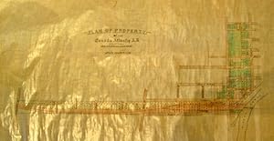
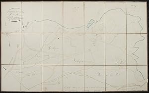
Plan of Property. -of the Canada Atlantic R.R. and Promoters Thereof. Scale 200 feet to 1 inch. Manuscript Map. On coated linen, in black & two colours, Plan includes from east west Gilmour, Argyle, Catharine and Isabella Streets., and from north to south; the Rideau Canal at Pretoria Bridge, Cartier, Elgin, Metcalfe, O'Connor, Bank to Concession Street. (Bronson ?). Lots are numbered
Published by Nd. [1890/1900?], 1900
Seller: J. Patrick McGahern Books Inc. (ABAC), Ottawa, ON, Canada
Seller rating 4 out of 5 stars
No Binding. Condition: Fine. sheet size: 69.5 (27.5") x 110 (43.25"), very good to fine (n12) J.R. Booth's Canada Atlantic Railroad, the worlds longest privately owned company, was sold to the Grand Trunk in 1905 for $14 million. Booth launched its construction in 1879, to speed his lumber to markets in northeastern American, via the Central Vermont Railway. The City of Ottawa thus found itself with a direct link to Boston. He later expanded the system west to Georgian Bay; this branch, which was complete in 1896, was known as the Ottawa, Arnprior and Parry Sound Railway. The whole system to Alburg, Vermont was then amalgamated as the Canada Atlantic Railway. (Trinnell. J.R. Booth).
-

The Returning Buyer's Map of Paris.
Publication Date: 1928
Seller: Geographicus Rare Antique Maps, Brooklyn, NY, U.S.A.
Association Member: ABAA ESA ILAB
Seller rating 4 out of 5 stars
Map
Soft cover. Good. Some edge wear and scuffing. Laid down on card. Size 12 x 9.5 Inches. This is a proof print of E. M. Cody's 1928 pictorial map of Paris that appeared on the cover of Fairchild's International Magazine , a trade journal for the fashion industry. A humorous work, it satirizes Americans' attitudes towards the French capital, particularly those of the American fashion elite who flooded Paris in September when the winter Haute Couture collections were released. A Closer Look Despite the joke compass at left, the map is oriented roughly towards the north, with the River Seine and the Eiffel Tower (labeled Citroen) in the foreground. Landmarks, restaurants, bars, hotels, and other recognizable locations are labeled throughout, with mock Anglicized names, such as the 'Champs Eliza' for the Champs-�lys�es and the 'Rue de Ravioli' for the Rue de Rivoli. Other locations and illustrations refer to the expatriate and literary scene in Paris, such as 'The Two Magots' (Les Deux Magots) caf� in the foreground and the Caf� de la Paix near the center, longtime meeting places of literary and artistic types of many nations. The Louvre ('The Louvy') is described as 'the biggest department store I ever seen!' The map's title, the magazine's name, the Folies Berg�re (at right), and an illustration of an automobile at the end of the Champs-�lys�es are ghosted in. Many of the jokes poke fun at Americans' consumerism, crudeness, and America-centrism, as with the replacement of Napoleon's statue on the Colonne Vend�me with George Washington and the stream of people leaving the American Express location towards the Caf� de la Paix. Americans in Paris Largely as a result of World War I (1914 - 1918), when many thousands of American doughboys passed through, Paris took on a revered and almost mythical status in the American imagination in the Interwar Period, especially among writers, artists, musicians, and fashion designers. An Anglo-American group of writers and artists, including Ernest Hemingway, Gertrude Stein, Ezra Pound, and James Joyce, all resided, worked (sometimes), and partied (often) throughout the 'ann�es folles' of 1920s Paris, memorialized in Hemingway's first novel, the roman � clef The Sun Also Rises (1926). Others, most famously Josephine Baker, found Paris far more accepting of Black people than the United States and decided to stay there. Composer George Gershwin only lived in Paris for a short time, but in 1928 composed one of the defining works of this milieu, the tone poem An American in Paris . Although cultural and linguistic barriers persisted, the era between roughly 1921 and the onset of the Great Depression witnessed considerable cross-cultural interaction and influence. The result was the distinctive, defining Art Deco aesthetic of the Jazz Age. Fairchild's International Magazine Fairchild's International Magazine was a richly-illustrated but relatively short-lived (Aug. 1926 - Feb. 1932) venture of the Interwar Period by the fashion-themed American company Fairchild Publications. Founded in 1892 by Edmund Fairchild, the company initially focused on men's fashion but found greater success in discussing and advertising women's fashion. Capitalizing on the increasing Transatlantic connections in the fashion world, Fairchild established offices in London, Paris, Berlin, and Vienna, and published Fairchild's International Magazine from both London and Paris. Likewise, the publication included advertisements in both French and English, although the articles were generally written in English. In effect, the magazine existed to disseminate the newest fashion trends from Paris each season to readers in London, New York, and beyond, including professionals in the clothing trade. However, some articles dealt with other trends in women's clothing; for example, the issue in which the present map appeared on the cover included an article on English clothiers designing practical outfits for female aviators. While perhaps.
-

Batiments Civils Projet de Ville de 500,000 Ames Sa�gon.
Publication Date: 1862
Seller: Geographicus Rare Antique Maps, Brooklyn, NY, U.S.A.
Association Member: ABAA ESA ILAB
Seller rating 4 out of 5 stars
Map
Soft cover. Good. Manuscript and wash. Laid down on archival paper. Some wear on old fold lines. Soiling. Size 26.5 x 30.75 Inches. This is Lucien Florent Paul Coffyn's 1862 manuscript masterplan of Saigon - the first and most significant map of Saigon (Ho Chi Minh City). Coffyn was the French military engineer tasked with transforming a war-torn fort into a model colonial capital. Following the 1861 French occupation of Saigon, authorities resolved to build a new city on the wartorn site at a monumental scale, reflecting boundless imperial ambition. Coffyn, driven by an unwavering belief in the colony's promise, envisioned a grand, European-style metropolis designed to accommodate half a million residents across 25 square kilometers. The present map - exquisitely drafted and signed by both Coffyn and Vice Admiral Louis Bonard, Governor of Cochinchina - is the likely original manuscript submitted for formal approval. Over the subseqeunt decades, Coffyn's street layout and placement of major sites were implemented with fidelity, though not comprehensively, marking this as the foundational document of colonial Saigon. It stands as a unique testament to French imperial planning and an unparalleled artifact of Asian colonial urbanism. A Closer Look The map is meticulously executed in grisaille pen and wash. It presents an ambitious polygonal city extending west from the Saigon River (S�ng S�i G�n) and exhibiting symmetry and perfection seemingly at odds with the swampy malarial terrain of the Mekong Delta. Coverage extends south to the Arroyo Chinois (T�u H?) and north to the Arroyo de l'Avalanche (Th? Ngh�), bother pre-existing rivers. The terrain was to be drained by a series of canals, including a belt canal ( canal de ceinture ), which would also serve a defensive function, and an expansive network of internal canals. The streets are laid out on a grid of 45� orthogonals radiating from a semicircular plaza on the waterfront. Streets throughout are numbered, with the sole exception being the proposed main street, Rue Imp�riale (now Hai B� Tr?ng Street), which runs northeast from the rondpointe . To the north of Rue Imp�riale is the Gouvernement et Administration Sup�rieure in the form of a large fort - the site of Saigon's existing La Citadelle du Phe?nix. To the Rue Imp�rial, he planned the city's commercial and industrial district, comprising some 2,300 hectares. The remainder was intended for residential development, including a large public park and water basin. Across the river to the east and south are proposed residential suburbs. The legend at lower right identifies 30 key locations: Gouvernement et Administration Sup.re - Supreme Government and Administration Office, located within La citadelle du Ph�nix. Caserne des Troupes Indig�nes - Barracks for Indigenous Troops. Caserne de Cavalerie - Barracks for Cavalry. Caserne d'Infanterie de Marine - Barracks for the Marines. Champ des Manuvres - Field for Military Manoeuvres. Cimeti�re - Cemetery. Prisons - Prisons. H�pital - Hospital. Arsenal - Arsenal. Caserne du G�nie - Barracks for the Engineering Corps. Magasine aux Vivres et Magasin G�n�ral - Food Storage Magazine and General Magazine. Construction Navales - Naval Construction Grounds. D�p�t de Charbons - Coal Depot. Gouvernement Provisoire (Doit devenir Place Pbl.) - Provisional Government Office (will become the Place Publique). Messagerie Imp�riales - Imperial Post and Telegraph Office. Direction du Port de Commerce - Commercial Harbour Master's Office. Direction du Port Militaire - Military Port HQ. Terrains occup�s provisoirement - Land temporarily occupied by Spanish Troops, Marine Artillery, Military Engineering, Hospital, Coolie's Depot, Hydrographic Office. Terrains occup�s provisoirement par Magasin G�n�ral - Land temporarily occupied by the General Magazine. Terrains occup�s provisoirement par Les Subsistances - Land temporarily occupied by the Military Storehouse. Terrains occup�s provi.
-

Plan de la Nouvelle Orleans Capitale de la Louisiana 1728.
Publication Date: 1880
Seller: Geographicus Rare Antique Maps, Brooklyn, NY, U.S.A.
Association Member: ABAA ESA ILAB
Seller rating 4 out of 5 stars
Map
Soft cover. Excellent. Manuscript map on thick stock. Size 5.5 x 6.25 Inches. This is an exceptional original c. 1880 manuscript draft map of New Orleans in 1728 drafted by eccentric German-American civil engineer Baron Ludwig von Reizenstein for later publication in George E. Waring Jr.'s influential 1881 History and Present Condition of New Orleans, Louisiana, and Report on the City of Austin, Texas . A Closer Look Waring's History and Present Condition of New Orleans, Louisiana, and Report on the City of Austin, Texas included an extensive history of the city of New Orleans from its founding until 1880. This historical section included 10 maps of New Orleans, both Reizenstein originals and versions of historical maps. The present map is Reizenstein's recreation of the map of Ignace-Fran�ois Broutin (1690 - 1751), an important surveyor and engineer in early French Louisiana, who produced maps of the city in 1728 and 1732, which themselves were based on an unsigned manuscript map (now held by the Biblioth�que nationale de France) titled 'Plan de la ville de la Nouvelle Orl�ans en l'�tat quelle �toit le 30 may 1725,' among the earliest maps of the city, believed to have been prepared by Adrien de Pauger (c. 1685 - 1726) and/or Valentin Devin (fl. c. 1719 - 1725). The map presents the burgeoning city, with the street grid (now the 'French Quarter') laid out by de Pauger easily recognizable. Several sites within the city and along its periphery, including residential quarters, the prison, mills, a brickyard, a riverside levee, magazine (poudri�re, likely the origin of the name Magazine St.), and the seat of government, are labelled or numbered, corresponding to an index at left. The 'Fleuve Saint Louis' (Mississippi River) flows before the city. Bayous, including the still-so-named Bayou St. John, and a drainage ditch (foss� d'�coulement) lay to the north of the city, towards Lake Pontchartrain. The Waring Report George E. Waring, Jr.'s History and Present Condition of New Orleans, Louisiana, and Report on the City of Austin, Texas was published in 1881 as part of a study commissioned in 1880 by the U.S. Census Bureau. In 1886, Waring's full report, the Report on the Social Statistics of Cities , was published to document and analyze the social, economic, and environmental conditions of urban centers in the United States. The Report sought to provide a detailed statistical overview of urban life, examining topics such as public health, infrastructure, housing, sanitation, and demographics. Its publication reflected the growing concerns of the time regarding urbanization, industrialization, and their impact on public well-being. The Report had a lasting influence on urban reform and public policy, leading to the implementation of large-scale public works projects, including sewer systems and public housing initiatives. His focus on sanitation and public health provided the foundation for modern urban hygiene practices, and his data-driven approach to social analysis became a model for subsequent studies on urban life. Publication History and Census As L. Reizenstein's original manuscript map, this is unique. A lithograph version of the map was published in George E. Waring Jr.'s History and Present Condition of New Orleans, Louisiana, and Report on the City of Austin, Texas . The History contained this and several other maps by Reizenstein, the original drafts for which Geographicus also holds. Even printed examples of this map from the History are very rare. These original drafts are both larger and more beautiful, in addition to being one of a kind. We do not know precisely when Waring commissioned Reizenstein to make the maps, but it must have occurred around 1880 when the Waring report was ordered as part of that year's census. As Waring notes in the report, the New Orleans section is the largest in the book, having been mostly completed before the report was ordered. A one-of-a-kind record of New Orleans history.
-
![Seller image for [Kingdom of Ayutthaya]. for sale by Geographicus Rare Antique Maps](https://pictures.abebooks.com/inventory/md/md32307609487.jpg)
[Kingdom of Ayutthaya].
Publication Date: 1957
Seller: Geographicus Rare Antique Maps, Brooklyn, NY, U.S.A.
Association Member: ABAA ESA ILAB
Seller rating 4 out of 5 stars
Map
Soft cover. Average. Manuscript. Overall toning. Color loss and surface scuffing. A few small holes. Laid down on old linen. Size 43 x 31.5 Inches. This is a large-format Thai-language c. 1957 manuscript historical wall map of Southeast Asia. It depicts the historical Kingdom of Ayutthaya, forerunner to modern Thailand, with a very generous border, a reflection of the ideological values of Pan-Thaiism. A Closer Look The map presents an aggrandized view of the territory of the Kingdom of Ayutthaya (1351 - 1767), stretching from what is today southern China to the Malay Peninsula and incorporating all of today's Thailand, Laos, and Cambodia, along with portions of China, Myanmar (Burma), and Vietnam. It is likely meant to resemble the putative territory of the kingdom during the reign of King Naresuan, also known as Naresuan the Great (r. 1590 - 1605). Coverage includes from Chittagong (????????) in today's Bangladesh at top-left to southern China (the Leizhou Peninsula and Hainan Island) at top-right, to Malacca (??????), the Malacca Straits, and Sumatra at bottom. Color-shading indicates the borders of kingdoms and territories, which are labelled in larger text (China ???, Malay ?????, and India ???????, among others, in addition to Ayutthaya), while many cities are noted throughout with red circles. Among Thai cities are those that are now large and well-known internationally like Chiang Mai (?????????), as well as smaller cities that were among the largest in the era of Ayutthaya Kingdom, such as it capital, Ayutthaya (??????, on the Chao Praya River not far from where Bangkok would later develop), Phitsanulok (????????), and Lopburi (??????), and Nan (????). Several cities are depicted as part of Ayutthaya but are not now part of neighboring countries, such as Vientiane (Lan Xang, ????????), Luang Prabang (??????????), and Battambang (????????), while several cities beyond the rule of Ayutthaya are easily recognizable by names they retained into the modern era, such as Hu? (???), Saigon (??????), and Taungoo (?????). Thai Irridentism and Historical Cartography The map reflects a strain of Thai irridentism and nationalism, known as Pan-Thaiism, that became pronounced in the 20th century, namely after the 1932 revolution, which transitioned the country from an absolute monarchy to a constitutional monarchy under a civilian-military regime. This ideology gained prominence particularly during the 1930s and early 1940s under the leadership of Field Marshal Plaek Phibunsongkhram (Phibun, 1897 - 1964), when the intellectual and statesman Luang Wichitwathakan (????????????????, 1898 - 1962) largely formulated it. This ideology was driven by two motives: the first being a claim that all Thai peoples in Southeast Asia were part of a single 'Thai Race,' and the second that Thailand (renamed from Siam in 1939 to emphasize Thai identity) needed to 'reunify' these peoples in a single political entity and reclaim lands that had historically been 'stolen' by malign foreign powers, both near (Burma) and far (France, Britain). These beliefs led Phibun to align with Japan after the Fall of France in 1940, which presented an opportunity to reclaim land in French Indochina. In exchange for facilitating Thai irredentism, Japanese forces were allowed to use Thailand as a staging ground for their invasions of British Malaya and Burma in December 1941. This alliance proved to be a major liability and caused Phibun to be removed from office in 1944 (he returned to power in the postwar period), though the United States took a more forgiving approach towards Thailand than the British and French, laying the foundations for a close relationship, including a military alliance, during the Cold War. From the 1930s, several cartographic projects aimed to establish historical legitimacy for Pan-Thaiism. At that time, maps began to be produced that claimed implausibly large borders for the greater Thai nation or race, often referring to the Ayutthaya Kingdom and especial.
-

Plan of New Orleans in 1770, by Capt. Pittman of the British Army.
Publication Date: 1880
Seller: Geographicus Rare Antique Maps, Brooklyn, NY, U.S.A.
Association Member: ABAA ESA ILAB
Seller rating 4 out of 5 stars
Map
Soft cover. Very good. Original manuscript draft. Some soiling to paper. Heavy stock. Size 9 x 11.5 Inches. This is an exceptional original c. 1880 manuscript draft map of New Orleans in 1770 drafted by eccentric German-American civil engineer Baron Ludwig von Reizenstein for later publication in George E. Waring Jr.'s influential 1881 History and Present Condition of New Orleans, Louisiana, and Report on the City of Austin, Texas . A Closer Look Waring's History and Present Condition of New Orleans, Louisiana, and Report on the City of Austin, Texas included an extensive history of the city of New Orleans from its founding until 1880. This historical section included 10 maps of New Orleans, both Reizenstein originals and versions of historical maps of the city. The present map is Reizenstein's recreation of Philip Pittman's map Plan of New Orleans published in his book The Present State of the European Settlements of the Missisippi in London in 1770. The 12 locations numerically identified here are identical to those on Pittman's map, including the church, the powder magazine, and the general hospital. However, Reizenstein moves Pittman's note, 'the dotted squares are lots not yet granted' from the bottom of the index to above the map. Reizenstein also adds the note above New Orleans and the note in the bottom-left corner, which states that 'the streets now called Rampart, Customhouse, and Barracks were then laid out as marked on this plan but no names at the time.' This map was commissioned around 1880 for George E. Waring Jr.'s History and Present Condition of New Orleans, Louisiana, and Report on the City of Austin, Texas , which contains a much-reduced version in lithograph. The Waring Report George E. Waring, Jr.'s History and Present Condition of New Orleans, Louisiana, and Report on the City of Austin, Texas was published in 1881 as part of a study commissioned in 1880 by the U.S. Census Bureau. In 1886, Waring's full report, the Report on the Social Statistics of Cities , was published to document and analyze the social, economic, and environmental conditions of urban centers in the United States. The Report sought to provide a detailed statistical overview of urban life, examining topics such as public health, infrastructure, housing, sanitation, and demographics. Its publication reflected the growing concerns of the time regarding urbanization, industrialization, and their impact on public well-being. The Report had a lasting influence on urban reform and public policy, leading to the implementation of large-scale public works projects, including sewer systems and public housing initiatives. His focus on sanitation and public health provided the foundation for modern urban hygiene practices, and his data-driven approach to social analysis became a model for subsequent studies on urban life. Publication History and Census As L. Reizenstein's original manuscript map, this is unique. A reduced lithograph version of the map was published in George E. Waring Jr.'s History and Present Condition of New Orleans, Louisiana, and Report on the City of Austin, Texas . The History contained this and several other maps by Reizenstein, the original drafts for which Geographicus also holds. Even printed examples of this map from the Report are very rare - just one example of the printed edition has appeared at auction, fetching 1000 USD, plus premium. These original drafts are both larger and more beautiful, in addition to being one of a kind. We do not know precisely when Waring commissioned Reizenstein to make the maps, but it must have occurred around 1880 when the Waring report was ordered as part of that year's census. As Waring notes in the report, the New Orleans section is the largest in the book, having been largely completed before the report was ordered. A one-of-a-kind record of New Orleans history.
-
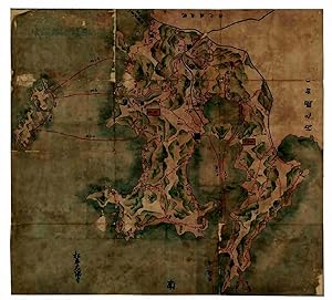
???. [Ezozu]. [Map of Ezo]
Published by Late Edo?, [Japan].
Seller: Asia Bookroom ANZAAB/ILAB, Canberra, ACT, Australia
Association Member: ANZAAB ILAB
Seller rating 5 out of 5 stars
Very attractive folding colour manuscript map of Ezo/Hokkaido, 82.3 x 165cm, folds into card covers with a title label on upper cover. Map a little time toned, card covers trifle insect damaged and marked. A very good copy of interesting and attractive map. This large sized hand drawn map of Ezo [Hokkaido] and surrounding regions covers the area from the northern end of Honshu to Karafuto [Sakhalin], and the far northeastern Asian mainland. Beyond the Japanese territory, the map shows Russia (including Kamchatka), China and Korea, and the mouth of the Amur River. The map also covers the southern Kuril Islands of Etorofu [Iturup] and Kunashiri [Kunashir], as well as other islands around Hokkaido. Several pieces of internal evidence suggest that this map may relate to the late 18th century growth of Japanese coastal trade around Ezo and as far as the southernmost ports of Karafuto. The distances of various sea routes from the ports of northern Honshu to landing points around the coast of Ezo and as far as southern Karafuto are marked in red, but it is significant that the person who produced the map was quite unfamiliar with the areas of Ezo north of the Oshima Peninsula in the far south of the island, and with all of Karafuto other than the villages on the southernmost coast. The shape of Ezo as drawn on the map is extremely forshortened, and the only part of Karafuto shown with even approximate acuracy is the shoreline of Aniwa Bay in the far south. Interestingly, the map's author has heard the names of some more northerly villages in Karafuto, such as Taraika, which he has added to the map, but he has guessed the shape of the island north of Aniwa Bay, making it much shorter and smaller than it is in reality. There are indications that the map was drawn (or is a copy of a work drawn) before the end of the 18th century. For example, it does not include the name of the port of Hakodate in southern Ezo, which had become a significant trading and administrative post by the first decade of the 19th century, nor does it include Shiranushi, the prinicipal Japanese trading post in southern Karafuto, established by Matsumae Domain in 1790. It does, however, include a fairly detailed outline of the Kuril Island of Iturup (Etorofu), with a note that 'in recent years Ezo [Ainu] and Russians have been trading here'. Russians are known to have visited Iturup to trade and exact 'tribute' [yasak] from the local Ainu population from about the 1760s-1770s onward. The map provides a fascinating illustration of gradually increasing knowledge of the northern regions and northeastern Asian mainland in Edo Period Japan.
-

All Eyes.
Publication Date: 1972
Seller: Geographicus Rare Antique Maps, Brooklyn, NY, U.S.A.
Association Member: ABAA ESA ILAB
Seller rating 4 out of 5 stars
Map
Hardcover. Very good. Manuscript and pastedown on art-board. Size 12 x 9 Inches. An original manuscript storyboard political cartoon by Jack Howells 'Herc' Ficklen satirizing national interest in the 1972 Democratic National Convention, held in Miami, Florida. The cartoon depicts Uncle Sam, representing the United States, looking downward at his beard - Florida. The cartoon features 'Little Longhorn', Ficklen's signature 'dingbat' introduced in 1971. The cartoon, entitled 'All Eyes' ran in the Dallas News in July of 1972. The carton bears a dedicated to Lee D. Saegesser. The famous NASA archivist and historian, suggesting it was presented to him as a gift from Ficklen, possibly due to its Florida focus. The 1972 Democratic Convention The 1972 Democratic Convention, held in Miami Florida, was one of the most significant in the history of American electioneering - when this cartoon was issued the eyes of the country were indeed on Florida. It was the first democratic convention to introduce new rules on delegate selection. These included quorum requirements for meetings, and quotas for women and minority groups. The convention also established much of the Democratic agenda that remains with us today, including equal rights, universal guaranteed income, anti-war policies, and more. In addition, it was the first campaign where an African American Woman, Shirley Chisholm (1924 - 2005) ran for president. While George McGovern ultimately received the nomination, Chisholm came in a strong 4th, strongly ahead of political mainstays like Ted Kennedy and Walter Mondale. McGovern lost the national election to Richard Nixon by largest landslide in any US Presidential election. Publication History and Census This is the original artwork for a political cartoon that ran in the Dallas News in 1972, during the Miami, Florida, democratic National Convention. As original artwork, it is the only known example.
-
![Seller image for Hitta-i Yemaniyye ve civari haritasidir [Map of the country of Yemen and its environs]. for sale by Antiquariat INLIBRIS Gilhofer Nfg. GmbH](https://pictures.abebooks.com/inventory/md/md31480354447.jpg)
Hitta-i Yemaniyye ve civari haritasidir [Map of the country of Yemen and its environs].
Published by [Ottoman Empire, 2 April 1911 CE =] 20 March 1327 (Rumi)., 1911
Seller: Antiquariat INLIBRIS Gilhofer Nfg. GmbH, Vienna, A, Austria
Association Member: ILAB PADA VDA VDAO
Seller rating 5 out of 5 stars
Hand-drawn and hand-coloured Ottoman Turkish map, 536 x 778 mm. Scale 1:1,000.000. Unique hand-drawn map of western Yemen, southern Arabia and the southern Red Sea, reaching from Aden, Djibouti's Gulf of Tadjoura, and the Bab-el-Mandeb in the south and as far north as Mecca, Jeddah, and Rabigh. The legend identifies the various symbols used in the map to show features of the land: fortresses, railroads ("simend�fer", chemin-de-fer), international and Sanjak borders, simple roads, and causeways ("sose", chauss�e). Apart from a few miles of rails inland from Hodeidah, no railways are shown in Arabia (the Hejaz railway had reached Medina in 1908 and not proceeded further), but several tracks are illustrated on the African side, some dubious. Dated 20 March 1327 (2 April 1911 CE), the map is signed with an unidentified monogram and inscribed as a gift to "Tevfik Bey Efendi, my comrade in misfortune" ("Refik-i felaketim Tevfik Beyefendi'ye yadigarimdir"). In the right margin, a series of pencil notes enumerate the various konaks (one-day travel stage posts) of the laborious land journey from Hodeidah to Sana'a. - The Sublime Porte had long sought to assert its authority in Yemen, and in 1872 had succeeded in establishing the Yemen Vilayet as an administrative division of the Ottoman Empire, though the vast area proved almost impossible to rule and continued to be plagued by insurrections. In early 1911 the Imam of Yemen, frustrated by the lack of progress in negotiations that had lasted for fully five years, began another revolt against the Ottomans: armed rebel bands arrived in Sana'a on 12 January 1911 and took over the city. The rebellion collapsed near the end of April, followed in October with the signing of the Treaty of Daan, which made Yemen a vassal state of the Ottoman Empire. It is very likely that the draughting of the present map was occasioned by the various Ottoman administrative and military operations taking place in Yemen during early April 1911. - Traces of folds which show a few insignificant paper and edge flaws. Drawn on high-quality Austrian "carta di disegno" paper with drystamp in one corner.
-
Oh-Sumi-Satsuma-Ryougoku-no Zu .
Published by Matsudaira Ohsumi, 1690
Seller: H�nersdorff Rare Books ABA ILAB, London, United Kingdom
Seller rating 2 out of 5 stars

Map First Edition
US$ 12,463.21
US$ 30.25 shipping
Ships from United Kingdom to U.S.A.Quantity: 1 available
Add to basketNo Binding. Condition: Good. No Jacket. 1st Edition. (JAPAN - Kagoshima peninsula). Oh-Sumi-Satsuma-Ryougoku-no Zu . [Kagoshima ? c1690] Coloured manuscript navigational map painted on paper (99.3 x 109cm ) with landscape and coastlines in coloured pictorial relief of blue, green and grey; charting distances between fortified towns, and nautical miles from ports to neighbouring islands in red; original calligraphic title and seal still visible in top left margin; lower left margin with calligraphic ownership signature for the daimyo Matsudaira Ohsumi-no-kami of the Shimazu clan, chief of the Osumi domain; mounted on paper; artist unknown. Folded in modern blue paper cover on soft cardboard with title inscription repeated. A fine manuscript map of the provinces of Satsuma and Osumi drawn up for its feudal lord, the daimyo Matsudaira Ohsumi-no-kami of the Shimazu clan, probably in order to provide geographical information of his large and politically important domain to the Shogunate which ordered each feudal lord to furnish a map of his fief, as a form of indirect control. The present map may be a copy of the original sent to the shogun. Japan had about 300 daimyo during this period with greatly varying sizes of territory, so that the map of the rich trading southwestern peninsula would have been of special interest to the government. The port city of Kagoshima became the capital of Satsuma province, the feudal territory of the powerful Shimazu clan which also controlled the Osumi domain. Such manuscript maps later provided the basis for a new map of Japan, known as the 'Genruko Map', completed in 1702. Charted are land and sea routes between the main castle towns and ports of the peninsula, the distances between them and the neighbouring islands. Reference is made to : Yakushima in the south, one of the Osumi islands (famous for its cedarwood - 135 km from Kagoshima), in the west, to the [Koshikijima] islands (not named - 40km from Kagoshima), to the north to : Tanegashima, another Osumi island (known as a historic landing point for the introduction of European firearms to Japan - 115km from Kagoshima), and to the Amakusa islands off the west coast of Kyushu, also ruled by the Shimazu clan during the Edo period (135 km from Kagoshima). An interesting provenance; the powerful daimyo Matsudaira-Ohsumi-no-Kami, chief of Osumi domain, had an annual rice yield of 600,000 koku (- see Kyoto University Economic Review, volume II, 1927, page 45). Repairs to sectional folds, corners & edges; mounted on paper. Generally well preserved.
-
![Seller image for Neue und Vollkom[m]ene Carten, des K�nigreich Bosnien, Sambt ihren darzugeh�rigen Provincien. Wie auch dessen Grosse und Kleine Vestungen, Sambt anderen �rthern, So Sich bis auff das 1737te Jahr befinden und Solche angemercket worden Seyn for sale by F�ldv�ri Books](https://pictures.abebooks.com/inventory/md/md14630165401.jpg)
Neue und Vollkom[m]ene Carten, des K�nigreich Bosnien, Sambt ihren darzugeh�rigen Provincien. Wie auch dessen Grosse und Kleine Vestungen, Sambt anderen �rthern, So Sich bis auff das 1737te Jahr befinden und Solche angemercket worden Seyn
Published by By Johannes Weingartner, 1740
Seller: F�ldv�ri Books, Budapest, Hungary
Seller rating 5 out of 5 stars
Condition: In fine condition. Manuscript, colored military map of Bosnia on linen with green silk edges, by Johannes Weingartner. 660 � 470 mm; 620 � 430 mm. Showing the borders and the fronts of the Habsburg Empire in Dalmatia and the Ottoman Empire in Bosnia on the day of the battle of Banja Luka, August 4, 1737. It was one of the main battles of the Russo-Turkish(-Austro) War (17351739) in which the Ottomans led by, Hekimo?lu Ali Pasha (16891758) grand vizier, defeated the Austrians, who entered the war a month before in July, 1737. With four vignettes of views of principal cities: Banja Luka, Biha?, Sarajevo (written "Seraglio" on the map, which is equivalent to "saray" or "serail" which means the governor's palace in Turkish) and Zvornik. . Manuscript, colored military map of Bosnia on linen with green silk edges, by Johannes Weingartner.
-

Manuscript ca 1800 in paper art cover, theology | Beautiful handmade paper map with decorated paper binding, inside manuscript ca 1800 with the title "korte aanleiding tot onderwijs in den waaren godsdienst", 13 pp.
Seller: Antiquariaat Arine van der Steur / ILAB, Den Haag, Netherlands
Seller rating 5 out of 5 stars
Beautiful handmade paper map with ribbon attached, circa 19th/early 20th century. Total size 22 x 17 cm. Inside manuscript on laid paper with watermark bij Adriaan Rogge with a whale and the text Adriaan Rogge. Rogge lived from 1732-1816 in Zaandam. He was a well known merchant, paper maker and seatrader. Manuscript with the title "korte aanleiding tot onderwijs in den waaren godsdienst". Hoofdstuk 1: Van de waaren godsdienst. Hoofstuk 2: Nader onderrigt van God, daarna Van de eersten gelukkigen toestand der menschen het verderf, van de verlossing door jesus christus, van het geloof in J.C. en deszelfs insigten op ons hart en leven, het gedrag van christenen, etc. No traces of the author of the manuscript.��.
-

Frankryk.
Publication Date: 1871
Seller: Geographicus Rare Antique Maps, Brooklyn, NY, U.S.A.
Association Member: ABAA ESA ILAB
Seller rating 4 out of 5 stars
Map
Very good. Minor spotting. Size 8 x 9 Inches. This is a whimsical 1871 manuscript map of France by J. C. Sikkel. Hand-drawn to show all of France, the map is incredible detailed and notes important rivers, towns, provinces, cities, islands, and surrounding regions. Includes the island of Corsica. Topography is beautifully rendered throughout. Features wonderful and whimsical overall presentation. This map was drawn in 1871 by J.C. Sikkel as part of Der Atlas Geheele Aarde .

![Seller image for Nivellirnyi plan goroda Tiflisa sostavlennyi po trianguliatsii, semke i invellirovke goroda v 1879-1881 gg. inzhenerami putei soobshcheniia S. Umanskim, A. Popovy, i P. Zamiatninym. [Plan of the City of Tiflis compiled by the Engineers S. Umanskiy, A. Popov and P. Zamiatnin]. for sale by Shapero Rare Books](https://pictures.abebooks.com/inventory/md/md32444947962.jpg)


![Seller image for ???. [Ezozu]. [Map of Ezo] for sale by Asia Bookroom ANZAAB/ILAB](https://pictures.abebooks.com/inventory/md/md32231408235.jpg)