Order Total (1 Item Items):
Shipping Destination:

Map Rapkin (28 results)
Skip to main search results
Search filters
Product Type
- All Product Types
- Books (14)
- Magazines & Periodicals (No further results match this refinement)
- Comics (No further results match this refinement)
- Sheet Music (No further results match this refinement)
- Art, Prints & Posters (No further results match this refinement)
- Photographs (No further results match this refinement)
- Maps (14)
- Manuscripts & Paper Collectibles (No further results match this refinement)
Condition Learn more
- New (No further results match this refinement)
- As New, Fine or Near Fine (No further results match this refinement)
- Very Good or Good (20)
- Fair or Poor (No further results match this refinement)
- As Described (8)
Binding
Collectible Attributes
- First Edition (10)
- Signed (No further results match this refinement)
- Dust Jacket (No further results match this refinement)
- Seller-Supplied Images (18)
- Not Print on Demand (28)
Language (2)
Free Shipping
- Free Shipping to U.S.A. (No further results match this refinement)
Seller Location
Seller Rating
-
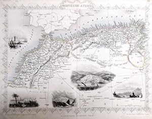
steal engraving / Grenzcolorierter Stahlstich Northern Africa. Mit weiteren 5 Bildstahlstichen 1)Mogador. 2) Marocco. 3) Constantine. 4) Algiers. 5)Tunis.
Language: English
Published by The London Printing and Publishing Company. o.J. [ca 1850], 1850
Seller: Antiquariat Carl Wegner, Berlin, B, Germany
Association Member: GIAQ
Seller rating 5 out of 5 stars

First Edition
Softcover. Blattgr��e 27x36 cm, Stichgr��e 21 x 30 cm, mittig l�ngs gefaltet. Die Tafel mit floraler Rahmung, eingezeichneten L�ngen- und Breitengraden und Ma�stabsangabe. Das Blatt an den R�ndern und in der Querfalte leicht lichtrandig und fingerfleckig, an der linken unteren Ecke eine Faltstelle, sonst sch�nes Exemplar. --- In english language. Good condition. Die Tafel beschriftet mit der Ziffer 61. Wahrscheinlich die entsprechende Tafel aus dem Werk von John Tallis: Illustrated atlas and modern history of the world. -- Zu dekorativen Zwecken, zum Rahmen geeignet. Weitere Karten aus dem gleichen Werk vorhanden. "John Rapkin was a mapmaker who was concerned with the aesthetic value of his work as well as cartographic content. His fine maps are distinguished by the trademark decorative borders, vignettes and title displays. Rapkin worked in close association with the equally respected publisher John Tallis. The publishing rights of many of the maps passed to The London Printing and Publishing Company circa 1850. " -- Bitte Portokosten au�erhalb EU erfragen! / Please ask for postage costs outside EU! / S ' il vous plait demander des frais de port en dehors de l ' UE! // Bitte beachten Sie auch unsere Fotos! / Please also note our photos! / Veuillez noter nos photos -- Sommerzeit daheim oder auf Reisen: bei uns finden Sie sicher ein passendes Buch zur Begleitung. -- Wir kaufen Ihre werthaltigen B�cher! GM25-502030.
-

Crimea War A Fine Original Antique Hand Coloured Map
Language: English
Published by London Printing, London, 1857
Seller: K Books Ltd ABA ILAB, York, YORKS, United Kingdom
Association Member: ABA ILAB PBFA
Seller rating 5 out of 5 stars
US$ 34.50
US$ 26.12 shipping
Ships from United Kingdom to U.S.A.Quantity: 1 available
Add to basketNo Binding. Condition: Very Good. Rapkin (illustrator). A fine original antique hand coloured map , colouring not contemporary but delicately and expertly executed . . Mounted (matted) and ready to frame. Central fold otherwise very good condition. A splendid opportunity to acquire an antique original map - decorative, attractive and scarce . A splendid map - the Battle of Sebastopol - details of position, camps and works, note of the battle position after the Battle of Alma and the Defence of the Malakoff Tower etc.
-
The Battle of the Alma - Showing the English, French , Russian and Turkish Forces - an Original Antique Engraved Map
Language: English
Publication Date: 1860
Seller: K Books Ltd ABA ILAB, York, YORKS, United Kingdom
Association Member: ABA ILAB PBFA
Seller rating 5 out of 5 stars
US$ 27.60
US$ 26.12 shipping
Ships from United Kingdom to U.S.A.Quantity: 1 available
Add to basketNo Binding. Condition: Very Good. Engraved By J. Rapkin (illustrator). An original antique engraved map, printed circa 1860. Hand-colouring contemporary. Mounted and ready to frame. A fine opportunity to purchase an attractive and decorative map - The Battle of the Alma - Showing the English, French , Russian and Turkish Forces on the 19th and 20th September, 1854. Lovley decoratively engraved frame.
-
THE CRIMEA - An Original Antique Hand Coloured Map
Language: English
Published by London Printing & Publishing Co, London, 1857
Seller: K Books Ltd ABA ILAB, York, YORKS, United Kingdom
Association Member: ABA ILAB PBFA
Seller rating 5 out of 5 stars
US$ 48.29
US$ 26.12 shipping
Ships from United Kingdom to U.S.A.Quantity: 1 available
Add to basketNo Binding. Condition: Very Good. Rapkin (illustrator). A fine original antique hand coloured map. Hand coloured, colouring not contemporary but delicately and expertly executed. Mounted (matted) and ready to frame. Central fold otherwise very good condition, . A splendid opportunity to acquire an antique original map - decorative, attractive and scarce . A splendid map - Crimea with vignettes of Sebastopol, Balaklava, Eupatoria etc and an inset map of Sebastopol.
-
BALTIC SEA - An Original Antique Hand Coloured Map
Language: English
Published by London Printing, London, 1857
Seller: K Books Ltd ABA ILAB, York, YORKS, United Kingdom
Association Member: ABA ILAB PBFA
Seller rating 5 out of 5 stars
US$ 48.29
US$ 26.12 shipping
Ships from United Kingdom to U.S.A.Quantity: 1 available
Add to basketNo Binding. Condition: Very Good. Rapkin (illustrator). A fine original antique hand coloured map, colouring not contemporary but delicately and expertly executed .Mounted (matted) and ready to frame. Central fold otherwise very good condition, . A splendid opportunity to acquire an antique original map - decorative, attractive and scarce . A splendid map of the Baltic Sea Area - Denmark, Sweden, Western Russia - with vignettes of St Petersburg, Helsingfors Kronstadt, Abo etc drawn and engraved by Winkles.
-
TURKEY IN EUROPE - An Original Antique Hand Coloured Map
Language: English
Published by LONDON PRINTING, London, 1857
Seller: K Books Ltd ABA ILAB, York, YORKS, United Kingdom
Association Member: ABA ILAB PBFA
Seller rating 5 out of 5 stars
US$ 48.29
US$ 26.12 shipping
Ships from United Kingdom to U.S.A.Quantity: 1 available
Add to basketNo Binding. Condition: Very Good. Rapkin (illustrator). A fine original antique hand coloured map, colouring not contemporary but delicately and expertly executed . . Mounted (matted) and ready to frame. Central fold otherwise very good condition. A splendid opportunity to acquire an antique original map - decorative, attractive and scarce . A splendid map of Turkey in Europe, with vignettes of Constantinople, Bosphorus, Ali Pasha etc with an inset map of Candia.
-
The Black Sea - An Original Antique Hand Coloured Map
Language: English
Published by London Printing, London, 1857
Seller: K Books Ltd ABA ILAB, York, YORKS, United Kingdom
Association Member: ABA ILAB PBFA
Seller rating 5 out of 5 stars
US$ 48.29
US$ 26.12 shipping
Ships from United Kingdom to U.S.A.Quantity: 1 available
Add to basketNo Binding. Condition: Very Good. Rapkin (illustrator). A fine original antique hand coloured map, colouring not contemporary but delicately and expertly executed . Mounted (matted) and ready to frame . . Central fold otherwise very good condition . A splendid opportunity to acquire an antique original map - decorative, attractive and scarce . A splendid map of the Black Sea area with vignettes of Sebastopol, Constantinople, Odessa, Varna etc.
-
Independent Tartary - Antiquarian Coloured Map
Language: English
Published by The London Printing and Publishing Company, London
Seller: K Books Ltd ABA ILAB, York, YORKS, United Kingdom
Association Member: ABA ILAB PBFA
Seller rating 5 out of 5 stars
US$ 62.09
US$ 26.12 shipping
Ships from United Kingdom to U.S.A.Quantity: 1 available
Add to basketNo Binding. Condition: Very Good. Engraved By J Rapkin (illustrator). An original antique map of the Independent Tartary printed ca. 1850. Mounted and ready to frame. Contemporary colouring in outline with hand-coloured vignettes of Tartars, Tartar life etc etc. In excellent condition, decorative and impressive. *Excellent map of Central Asia.
-
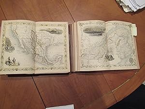
The History And Topography Of The United States Of America. Fourth Edition, With Folding Map "Mexico, California, And Texas. The Newly Discovered Gold Districts" Illustrated By H Warren, Illustrations Engraved By J Rogers, Map By J. Rapkin
Language: English
Published by The London Printing and Publishing Company - Limited, London and New York, 1850
Seller: Arroyo Seco Books, Pasadena, Member IOBA, Pasadena, CA, U.S.A.
Association Member: IOBA
Seller rating 4 out of 5 stars

First Edition
Half Leather. Condition: Good. 3 Colored Maps, 22 Colored Plates, 30 Uncolored Plates (illustrator). First Edition Thus. Two Volumes, Three Quarter Leather. Volume 1: 944 Pp With 30 Uncolored Plates And One Colored Map "Mexico, California, And Texas: The Newly Discovered Gold Districts". Volume Ii: 784 Pp With Two Colored Maps Of Canada, And 22 Colored Plates, All With Yellow Borders And Nice Original Color Throughout. The Map Of Mexico And California, Tipped In But Neatly Loosened And Detached (Without Intention) And Usually Not Present, Has Nicely Detailed Illustrations Of The Ruins At Uxmal, Yucatan, Mexican Peasantry, And Gold Washing, And Outlines The Gold Districts Of The U S And Mexico In Yellow. No Date Of Publication Indicated But Presumably 1850. Bindings Poor, Three Of Four Boards Detached, Spines Perished, Boards Very Worn And Frayed, Deserving Of An Expensive Rebind. Contents Near Fine, Clean, Maps Perfectly Preserved. Volume I With Additional Illustrated Title Page, Showing Penn's Treaty, Painted By Benjamin West And Here Engraved By J. Rogers. This Greatly Enlarged Fourth Edition With The Colored California Gold Map Is Uncommon, About 7 Holdings Shown In Worldcat; It Is Not Listed In Carl Wheat's "The Maps Of The California Gold Region 1848 - 1857", Nor In The Addendum To The 1997 Martino Reprint Of That Book.
-
Peru and Bolivia.
Language: English
Published by From the Montgomery Martin Illustrated Atlas, London, 1851
Map First Edition
US$ 55.19
US$ 46.89 shipping
Ships from United Kingdom to U.S.A.Quantity: 1 available
Add to basketNo Binding. Condition: Very Good. Map engraved by Rapkin. Illustrations H Warren (illustrator). 1st Edition. Tallis, John: Peru and Bolivia. London. [ca.1851]. From the Montgomery Martin Illustrated Atlas. Map engraved by Rapkin. Size approx 360 x 260mm. Original steel engraved map with original outline hand colouring. 4 vignettes include Lima, Potosi, Swimming Couriers of Peru. Decorative Border. Single page unfolded map in good order, two faint fox marks in map area, printers imk mark on the sky of Potosi illustration. Associated text page of the Montgomery Martin Atlas included. A good Tallis Map.
-
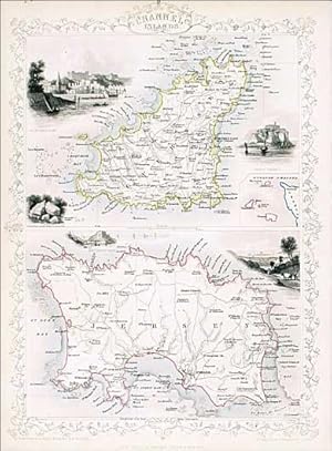
Channel Islands, Tallis, ca.1851
Language: English
Published by From the Montgomery Martin Illustrated Atlas., London, 1851
Map First Edition
US$ 68.99
US$ 46.89 shipping
Ships from United Kingdom to U.S.A.Quantity: 1 available
Add to basketNo Binding. Condition: Very Good. No Jacket. Map engraved by Rapkin. (illustrator). 1st Edition. Tallis, John: Channel Islands. London. [ca.1851]. From the Montgomery Martin Illustrated Atlas. Map engraved by Rapkin. Size approx 360 x 260mm. Original steel engraved map with original outline hand colouring. 5 vignettes include St Peters Port, Castle Cornet, Druidian Alter near Lancresse, Mount Orgueil Castle and Jersey. Decorative border encloses 2 maps of the large islands of Jersey and Guernsey with an inset of the other islands. Single page unfolded map in excellent, clean condition. Associated text page of the Montgomery Martin Atlas included. A good Tallis Map.
-
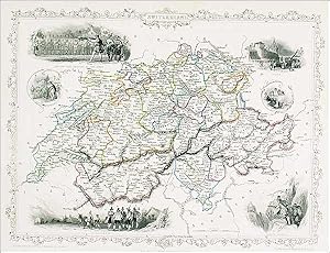
Switzerland, Tallis, ca.1851
Language: English
Published by From the Montgomery Martin Illustrated Atlas., London, 1851
Map First Edition
US$ 82.79
US$ 46.89 shipping
Ships from United Kingdom to U.S.A.Quantity: 1 available
Add to basketNo Binding. Condition: Very Good. Map engraved by Rapkin. (illustrator). 1st Edition. Tallis, John: Switzerland, London. [ca.1851]. From the Montgomery Martin Illustrated Atlas. Map engraved by Rapkin. Size approx 360 x 260mm. Original steel engraved map with original outline hand colouring. 6 vignette views including Bern, Chamois Hunters and William Tell shooting at the apple. Decorative border. Single page unfolded map in clean condition, two small fox marks in France and Italy area of the map. Associated text page of the Montgomery Martin Atlas included.
-
Turkey in Asia, Tallis, ca.1851
Language: English
Published by From the Montgomery Martin Illustrated Atlas., London, 1851
Map First Edition
US$ 82.79
US$ 46.89 shipping
Ships from United Kingdom to U.S.A.Quantity: 1 available
Add to basketNo Binding. Condition: Very Good. Map engraved by Rapkin. Illustrations H Warren (illustrator). 1st Edition. Tallis, John: Turkey in Asia. London. [ca.1851]. From the Montgomery Martin Illustrated Atlas. Map engraved by Rapkin. Size approx 360 x 260mm. Original steel engraved map with original outline hand colouring. 4 vignettes include Jerusalem and the Castles of Europe and Asia. The map area covers modern day Turkey, Cyprus, Israel, Lebanon, Syria, Jordan and Iraq. Decorative Border. Single page unfolded map in excellent, clean condition. Associated text page of the Montgomery Martin Atlas included.
-
Russia in Europe
Language: English
Published by From the Montgomery Martin Illustrated Atlas, London, 1851
Map First Edition
US$ 82.79
US$ 46.89 shipping
Ships from United Kingdom to U.S.A.Quantity: 1 available
Add to basketNo Binding. Condition: Very Good. Map engraved by Rapkin (illustrator). 1st Edition. Tallis, John: Russia in Europe. London. [ca.1851]. From the Montgomery Martin Illustrated Atlas. Map engraved by Rapkin. Size approx 360 x 260mm. Original steel engraved map with original outline hand colouring. 7 vignettes include Travelling Sledge, Napoleans flight from Moscow, and Polish Captives on their way to Siberia. Decorative Border. Single page unfolded map in excellent, clean condition. Associated text page of the Montgomery Martin Atlas included.
-
Islands of the Atlantic
Language: English
Published by From the Montgomery Martin Illustrated Atlas, London, 1851
Map First Edition
US$ 96.59
US$ 46.89 shipping
Ships from United Kingdom to U.S.A.Quantity: 1 available
Add to basketNo Binding. Condition: Very Good. Map engraved by Rapkin. (illustrator). 1st Edition. Tallis, John: Islands of the Atlantic. London. [ca.1851]. From the Montgomery Martin Illustrated Atlas. Map engraved by Rapkin. Size approx 360 x 260mm. Original steel engraved map with original outline hand colouring. 6 vignettes include Pico Azores, Tenerife, Canary Islands, Funchai [Funchal], Maderia [Madeira] and Nilla Franca Azores. Decorative border. Single page unfolded map in excellent, clean condition. Associated text page of the Montgomery Martin Atlas included. A good Tallis Map.
-
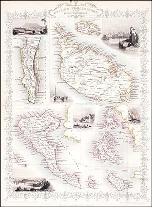
Original Map. British Possessions in the Mediterranean
Language: English
Published by From the Montgomery Martin Illustrated Atlas, London, 1851
Map First Edition
US$ 96.59
US$ 46.89 shipping
Ships from United Kingdom to U.S.A.Quantity: 1 available
Add to basketNo Binding. Condition: Very Good. Map engraved by Rapkin. (illustrator). 1st Edition. Tallis, John: British Possessions in the Mediterranean, London. [ca.1851]. From the Montgomery Martin Illustrated Atlas. Map engraved by Rapkin. Size approx 360 x 260mm. Original steel engraved map with original outline hand colouring. 6 vignettes include Valetta, Corfu, Vathi Ithac and Gibraltar. Decorative border. Single page unfolded map in excellent, clean condition. Associated text page of the Montgomery Martin Atlas included. A good Tallis Map.
-
MAP OF PART OF SOUTH AUSTRALIA Centred Round Spencer Gulf
Language: English
Published by JOHN TALLIS, LONDON, 1850
Seller: K Books Ltd ABA ILAB, York, YORKS, United Kingdom
Association Member: ABA ILAB PBFA
Seller rating 5 out of 5 stars
US$ 117.29
US$ 26.12 shipping
Ships from United Kingdom to U.S.A.Quantity: 1 available
Add to basketNo Binding. Condition: Very Good. H WARREN. J ROGERS J RAPKIN (illustrator). Antique map . Hand coloured, engraved map. mounted - matted - and ready to frame .10 x 13 inches. a vg copy of an attractive decorative hand coloured antique map. . A splendid map, colouring not contemporary but delicately and expertly done - a fine map of part of South Australia with colour washed vignettes of Adelaide, the seal of South Australia, a dingo, aborigines on a Catamaran and a bird called a Nymphicus.
-
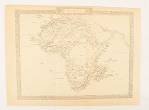
Africa.
Published by The London Printing and Publishing Company. [Circa1880s]., London., 1880
Seller: Asia Bookroom ANZAAB/ILAB, Canberra, ACT, Australia
Association Member: ANZAAB ILAB
Seller rating 5 out of 5 stars
Printed map, 24 x 32.1 cm, decorative border, two original vertical folds, paper toned, mainly at the edges, inner margin of the sheet ragged, but in good order. A late edition of the map used for the well-known Tallis map, this without the characteristic vignettes and on thinner paper.
-
South Australia. Tallis, ca.1851
Language: English
Published by From the Montgomery Martin Illustrated Atlas., london, 1850
Map First Edition
US$ 110.39
US$ 46.89 shipping
Ships from United Kingdom to U.S.A.Quantity: 1 available
Add to basketNo Binding. Condition: Very Good. Map engraved by Rapkin. (illustrator). 1st Edition. Tallis, John: South Australia. London. [ca.1851]. From the Montgomery Martin Illustrated Atlas. Map engraved by Rapkin. Size approx 360 x 260mm. Original steel engraved map with original outline hand colouring and decorative border. 5 vignettes include Australian Dog, Natives on a Catamaran and Adelaide. Single page unfolded map in excellent, clean condition. Associated text page of the Montgomery Martin Atlas included. A good Tallis Map.
-
MAP OF VICTORIA, OR PORT PHILLIP, AUSTRALIA.
Language: English
Published by JOHN TALLIS, LONDON, 1850
Seller: K Books Ltd ABA ILAB, York, YORKS, United Kingdom
Association Member: ABA ILAB PBFA
Seller rating 5 out of 5 stars
US$ 137.98
US$ 26.12 shipping
Ships from United Kingdom to U.S.A.Quantity: 1 available
Add to basketNo Binding. Condition: Very Good. A WARREN. J ROGERS J RAPKIN (illustrator). Antique map . Hand coloured, engraved map. mounted - matted - and ready to frame .10 x 13 inches. a vg copy of an attractive decorative hand coloured antique map. . A splendid map, colouring not contemporary but delicately and expertly done - a fine map of Victoria or Port Phillip, with colour washed vignettes of kangaroos, aborigines, Melbourne and the River Glenelg.
-
MAP OF NEW SOUTH WALES, AUSTRALIA.
Language: English
Published by JOHN TALLIS, LONDON, 1850
Seller: K Books Ltd ABA ILAB, York, YORKS, United Kingdom
Association Member: ABA ILAB PBFA
Seller rating 5 out of 5 stars
US$ 137.98
US$ 26.12 shipping
Ships from United Kingdom to U.S.A.Quantity: 1 available
Add to basketNo Binding. Condition: Very Good. H WARREN. J ROGERS J RAPKIN (illustrator). Antique map . Hand coloured, engraved map. mounted - matted - and ready to frame .10 x 13 inches. a vg copy of an attractive decorative hand coloured antique map. . A splendid map, colouring not contemporary but delicately and expertly done - a fine map of New South Wales, Australia with colour washed vignettes of the Murray River, Sydney Cove and a Xanthorrhaea plant.
-

The World Mercator's Projection Shewing the Voyages of Captain Cook Round the World
Published by London. John Tallis & Co. 1851, 1851
Seller: J. Patrick McGahern Books Inc. (ABAC), Ottawa, ON, Canada
Seller rating 4 out of 5 stars
sheet size 27x 36cm, image size 19.5x30cm, centre fold as issued, outline colour, very good to fine. (Ads).
-

US$ 136.60
US$ 8.71 shipping
Ships from United Kingdom to U.S.A.Quantity: 1 available
Add to basketNo Binding. Condition: Very Good. Original antique map with original hand colouring of the county boundaries as issued. Vignettes of London, Oxford, Portsmouth Harbour, Sunderland Bridge, Newcastle-upon-Tyne, Doncaster Races and Hunting. The border is topped by the Royal coat of arms and with drawings in the corners showing agriculture, commerce, science and the arts. Early edition without centrefold. Full margins all round. Toned verso but not showing on the face. Sold with ivory bevelled mount and a single ruling. Mount window 25.5 x 35.5. Overall size 35.5 x 45.5. The size of the mount makes it a Medium Parcel so shipping in UK �6. Shipped without mount, if preferred. 26.5 x 37 cm.
-

Southern India - including the Presidencies of Bombay and Madras.
Publication Date: 1851
Seller: Geographicus Rare Antique Maps, Brooklyn, NY, U.S.A.
Association Member: ABAA ESA ILAB
Seller rating 4 out of 5 stars
Map
Very good. Original fold line visible at center. Slight dampstain in top margin. Size 13.5 x 10.5 Inches. This is a rare 1851 map of India drawn and engraved by John Rapkin that appeared in Tallis's Illustrated Atlas and Modern History of the World . The map and illustrations reflect the recent Anglo-Sikh War (1845 - 1846) and show the divisions of the Indian subcontinent soon before the 1857 Mutiny and the inception of the Raj. Company Rule in India The map shows the arrangement of princely states and 'presidencies' (areas directly-ruled by the British East India Company) that ruled over the Indian subcontinent prior to the creation of the British Raj. The illustrations mostly show locations in northern India that are not on the map, such as the Government House (now Raj Bhavan) in Calcutta, the Fortress of Shuhur (otherwise known as Amer or Amber Fort) in Jaipur, and the tomb of Muhammad Shah in Delhi. At bottom-right is an illustration without a caption that shows British soldiers writing on a monument: Moodkee, Ferozeshah, Sobraon. These were sites of pivotal battles in the Anglo-Sikh War, with Sobraon being a decisive British victory which ended the war. Background and Aftermath Until the mid-18th century, the British East India Company (EIC) was similar to the East India Companies of other European powers in that it mostly operated in coastal ports and did not seek to control large portions of territory. That changed when the company expanded its interests in Bengal from a 'factory' (trading post) to gaining the right to collect taxes in Bengal, followed by de facto and eventually de jure rule over Bengal and Bihar. The Battle of Plassey in 1757, an oft-forgotten turning point in world history, gave the British the upper-hand over their competitors in India (particularly the French) and set a precedent of exploiting tensions between local Indian states to expand the power of the EIC. By the time this map was made, the EIC effectively controlled the entire Indian subcontinent, usually through intermediaries, local rulers who had aligned themselves with the company. For instance, in the recent Anglo-Sikh War, Gulab Singh, an important Sikh provincial governor, had remained neutral and, once the conflict had ended, paid the EIC 7.5 million rupees plus an annual indemnity and in exchange was made the Maharaja of Jammu and Kashmir. His descendants remained loyal to the British and retained the autonomy of Jammu and Kashmir until the end of the Raj. Although an autonomous entity, the EIC was increasingly subject to oversight by the British Parliament due to a series of scandals involving corruption and exploitation of the local population. Nevertheless, the company was so profitable and politically powerful that it was difficult to rein in. The conduct and taxes of the EIC irritated Indian landholders, while racial discrimination and a number of social and legal reforms agitated commoners, culminating in the massive rebellion of 1857 - 1858. The uprising began in the ranks of the EIC military itself, among Indian troops known as sepoys, but soon spread to a general social revolt that varied widely by region, religion, and social class. Notably, most of the princely states that had operated with limited autonomy under the EIC remained loyal to it or at least maintained neutrality, including the recently-defeated Sikhs. After the rebellion was suppressed, the EIC was nationalized, and India came under direct rule of the British Crown as the Raj. Publication History and Census This map was part of the well-known Tallis's Illustrated Atlas and Modern History of the World published in 1851. It was drawn and engraved by John Rapkin and the vignette illustrations were drawn by A.H. Wray and engraved by J.H. Kernot. It is held by several libraries in North America, Great Britain, and in former territories of the British Empire (Australia, Singapore). References: Rumsey 0466.033. OCLC 46783270.
-

New South Wales.
Publication Date: 1851
Seller: Geographicus Rare Antique Maps, Brooklyn, NY, U.S.A.
Association Member: ABAA ESA ILAB
Seller rating 4 out of 5 stars
Map
Good. Exhibits soiling in all four corners. Blank on verso. Size 14 x 10.5 Inches. This is an 1850 John Tallis map of New South Wales, Australia highlighting the many gold claims peppered throughout the region. The map depicts eastern Australia from the Great Sandy Island south past Sydney to Cape Howe and extends a considerable distance inland despite the region being only tenuously mapped. Gold claims are marked by dashed lines and highlighted with bright gold colored ink. Beautiful illustrations by H. Warren depicting The Murray, a Xanthorrhaea (a plant endemic to Australia) and the Sydney Cove are also present. The seal of New South Wales is situated in the upper left corner. The map also notes the 1817 John Oxley's 1817 route is traced, along with that of Charles Sturt. The whole has the highly decorative presentation and elaborate border distinctive of Tallis maps. Australian Gold Rush of 1851 Gold was known to be present in Australia prior to 1851, but the intentional suppression of this information by the colonial government of New South Wales prevented all-out gold rushes. When gold was discovered at Sutter's Mill, California, in 1848, causing the California Gold Rush, countless Australians migrated in search of their fortunes. Desirous of maintaining their dwindling work force, the colonial governors rethought their position, and sought approval from the Colonial Office in England to allow the exploitation of the mineral resourcesand alsooffered rewards for the finding of payable gold. This led to the first major Australian gold rush when prospector Edward Hargraves discovered gold at Ophir, near Orange. A series of subsequent discoveries followed, transforming the Australian economy and leading to a rush of new immigration. Publication History This map was drawn and engraved by John Rapkin, with illustrations drawn by H. Warren and engraved by J. Rogers. It was published by John Tallis and Company in 1851.
-

Western Australia, Swan River.
Publication Date: 1851
Seller: Geographicus Rare Antique Maps, Brooklyn, NY, U.S.A.
Association Member: ABAA ESA ILAB
Seller rating 4 out of 5 stars
Map
Very good. Minor wear along original centerfold. Minor spotting. Blank on verso. Size 14 x 10.5 Inches. This is a scarce 1851 example of John Tallis and John Rapkin's 1851 map of Western Australia. It covers southwestern Western Australia from Champion Bay south around Sussex to Doubtful Island Bay. This map records the early settlements of the United Kingdom in the western part of Australia. It notes numerous counties, roadways, rivers, geographical features, and more. Swan River is identified. The Swan River Colony including Perth was settled by the British in 1829. York, noted here, was the first inland settlement by the British in 1831. Albany with King George Sound, along with its surrounding areas is called Plantagenet, supposedly named so because King George, the reigning British monarch at the time, believed that he was related to the Plantagenet lineage of kings, who ruled many centuries earlier. This map includes illustrations by A. H. Wray of Sheep Shearing, Aborigines, Perth from Mount Eliza and a view Between Perth and Fremantle. Illustrations of ships and natives is also included. The whole has the highly decorative presentation and elaborate border distinctive of Tallis maps. This map was issued as part of the 1851 edition of John Tallis and Company's The Illustrated Atlas, And Modern History of the World . References: Rumsey 0466.055. Phillips (Atlases) 804.
-

New South Wales.
Publication Date: 1851
Seller: Geographicus Rare Antique Maps, Brooklyn, NY, U.S.A.
Association Member: ABAA ESA ILAB
Seller rating 4 out of 5 stars
Map
Very good. Blank on verso. Size 14 x 10.5 Inches. This is a fine 1851 John Tallis map of New South Wales, Australia. The map covers eastern Australia from the Great Sandy Island south past Sydney to Cape Howe. It also extends a considerable distance inland despite the region being only tenuously mapped. This map was issued in the same year as Victoria became an independent colony separate from New South Wales in July, 1851. This year also marked the beginning of the Australian gold rush, which would attract a large number of international immigrants, tripling its population within the next 20 years. The map includes beautiful illustrations by H. Warren depicting The Murray, Xanthorrhaea and the Sydney Cove. The seal of New South Wales is also illustrated. The map also notes the 1817 routes of John Oxley, who discovered the Brisbane River. The whole has the highly decorative presentation and elaborate border distinctive of Tallis maps. This map was issued as part of the 1851 edition of John Tallis and Company's The Illustrated Atlas, And Modern History of the World . References: Rumsey 0466.052. Phillips (Atlases) 804.
-

Victoria or Port Phillip.
Publication Date: 1851
Seller: Geographicus Rare Antique Maps, Brooklyn, NY, U.S.A.
Association Member: ABAA ESA ILAB
Seller rating 4 out of 5 stars
Map
Very good. Minor wear along original centerfold. Minor spotting. Blank on verso. Size 10.5 x 14 Inches. This is a scarce 1851 map of Victoria or Port Phillip, Australia by John Tallis. The map covers Victoria from Discovery Bay east past Melbourne to Mallacoota (Mallagoota). It also extends a considerable distance inland despite the region being only tenuously mapped. Victoria on this map is identified as 'Australia Felix' (the early name given to the lush green pastures of western Victoria). This map was issued in the same year as Victoria became an independent colony separate from New South Wales in July, 1851. This year also marked the beginning of the Australian gold rush, which would attract a large number of international immigrants, tripling its population within the next 20 years. The gold digging sites are marked in yellow throughout. The map includes beautiful illustrations by H. Warren depicting, Melbourne, and the River Glenelg, a kangaroo and indigenous people or Aborigines. The whole has the highly decorative presentation and elaborate border distinctive of Tallis maps. This map was issued as part of the 1851 edition of John Tallis and Company's The Illustrated Atlas, And Modern History of the World . References: Rumsey 0466.053. Phillips (Atlases) 804.