
Order Total (1 Item Items):
Shipping Destination:

Robijn Jacob (5 results)
Skip to main search results
Search filters
Product Type
- All Product Types
- Books (4)
- Magazines & Periodicals (No further results match this refinement)
- Comics (No further results match this refinement)
- Sheet Music (No further results match this refinement)
- Art, Prints & Posters (No further results match this refinement)
- Photographs (No further results match this refinement)
- Maps (1)
- Manuscripts & Paper Collectibles (No further results match this refinement)
Condition Learn more
- New (No further results match this refinement)
- As New, Fine or Near Fine (1)
- Very Good or Good (3)
- Fair or Poor (No further results match this refinement)
- As Described (1)
Binding
- All Bindings
- Hardcover (4)
- Softcover (No further results match this refinement)
Collectible Attributes
- First Edition (No further results match this refinement)
- Signed (No further results match this refinement)
- Dust Jacket (1)
- Seller-Supplied Images (4)
- Not Print on Demand (5)
Language (2)
Price
- Any Price
- Under US$ 25 (No further results match this refinement)
- US$ 25 to US$ 50 (No further results match this refinement)
- Over US$ 50
Free Shipping
- Free Shipping to U.S.A. (No further results match this refinement)
Seller Location
Seller Rating
-
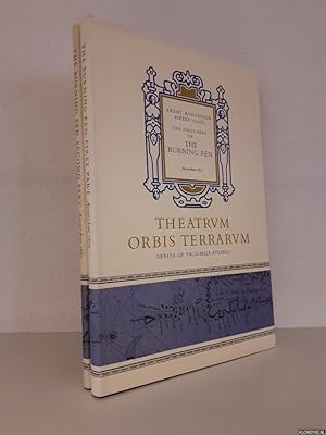
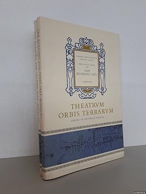
The Burning Fen Second Part Amsterdam 1687
Language: English
Published by Theatrum Orbis Terrarum Ltd., Amsterdam, 1971
ISBN 10: 9022110303 ISBN 13: 9789022110300
Hardcover. Condition: Near Fine. Dust Jacket Condition: Very Good. Arent Roggeveen and Jacob Robijn. The Burning Fen Second Part Amsterdam 1687. Amsterdam: Theatrum Orbis Terrarum Ltd., 1971, xii, 40 pp. + maps. *** This atlas is one in a series of facsimile atlases resurrected and produced by the Theatrum Orbis Terrarum project. The Burning Fen is the 4th. part of the new Great Sea-Mirrour, first published in 1687. It is a Pilot for the West African and Brazilian coasts. Historical background for this work is provided in an Introduction by Prof. Ir C. Koeman. The atlas contains large double-page maps done in the portolan style, with coastline views and sailing directions. With the original illustrated Dust Jacket. This book is in my inventory and the images are of this particular item. *** Bound in dark blue cloth boards and spine, clean with no wear, bottom corners lightly bumped. The jacket is clean with very light wear, one faint mark at bottom of front panel, a tiny closed tear (repaired on verso with archival tape) and a small wrinkle bottom right corner of front panel. The contents are clean and complete in a good binding. *** 18.25 inches tall by 12.25 inches.
-
The First Part of the Burning Fen - Amsterdam 1675 & The Second Part of the Burning Fen - Amsterdam 1687 (2 volumes)
Language: English
Published by Amsterdam : Theatrum Orbis Terrarum Limited, 1971
ISBN 10: 902211029X ISBN 13: 9789022110294
Condition: Good. 2 unirform original gilt lettered cloths, dust jackets, (double page) illustrations in b/w, folio. Theatrvm Orbis Terrarvm, Series of Facsimile Atlases, Fifth Series, Volume V and VI.
-
The First Part of the Burning Fen - Amsterdam 1675 & The Second Part of the Burning Fen - Amsterdam 1687 (2 volumes)
Language: English
Published by Amsterdam : Theatrum Orbis Terrarum Limited, 1971
ISBN 10: 902211029X ISBN 13: 9789022110294
Condition: Good. 2 uniform original gilt lettered cloths, dust jackets, (double page) illustrations in b/w, folio. Theatrvm Orbis Terrarvm, Series of Facsimile Atlases, Fifth Series, Volume V and VI.
-

The First Part of the Burning Fen - Amsterdam 1675 & The Second Part of the Burning Fen - Amsterdam 1687 (2 volumes) Roggeveen, Arent & Pieter Goos & Jacob Robijn
Language: English
Published by Amsterdam : Theatrum Orbis Terrarum Limited, 1971
ISBN 10: 902211029X ISBN 13: 9789022110294
Seller: BUCHSERVICE / ANTIQUARIAT Lars Lutzer, Wahlstedt, Germany
Seller rating 5 out of 5 stars

Hardcover. Condition: gut. 1971. The First Part of the Burning Fen - Amsterdam 1675 & The Second Part of the Burning Fen - Amsterdam 1687 (2 volumes) In deutscher Sprache. pages.
-
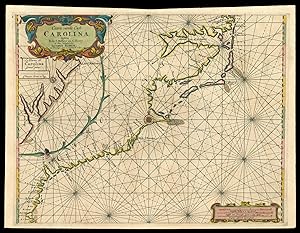
Caerte vande Cust Carolina Tusscheb B de S Matheo en C. Henry op Niew Verbeetert door
Published by Jacobus Robyn met Privilegio Voor is Iaaren A'o, Amsterdam,, 1687
Seller: Daniel Crouch Rare Books Ltd, London, United Kingdom
Association Member: ABA ILAB PBFA
Seller rating 4 out of 5 stars

Map
US$ 34,704.10
US$ 26.95 shipping
Ships from United Kingdom to U.S.A.Quantity: 1 available
Add to basketCarolina First state. Double-page engraved chart, with fine hand-colour in part and in outline. Large-scale sea chart of the Carolina coast - published in Roggeveen's exceedingly rare sea pilot 'Het Brandende Veen'. In 1687 Robijn replaced the earlier chart of the south-east with this one. It is interestingly derived from Johannes van Keulen's 'Pas Kaart Van de Kust van Carolina,' 1684, the publisher whom he had been working with in 1679. Robijn rotates the projection to a north-south one and in the process eliminates the south portion of Chesapeake Bay. The coastline is virtually identical but nomenclature does vary. One notable new addition is B de S. Anna and a sand bar is also placed at C Faire. The position of Charles Town is still on the south bank of the Rio Grande, a position from which it relocated in 1680. Roggeveen, born in Delshaven, came to Middleburg, the seat of both the Dutch East and West India Companies, in 1658. He worked for both companies teaching the art of navigation and helped to maintain their collections of hydrographic manuscripts and charts, including Spanish portolans of the West Indies. In the mid-1660s, assisted by his access to these collections, Roggeveen embarked upon compiling a series of large-scale charts of the North American coastline, West Indies, and, later, West Africa. Many of his charts are based upon the earlier large-scale work of Hessel Gerritsz and Joan Vingboons, both cartographers for the Dutch East and West India Companies, but Roggeveen's work was the first to show the whole coastline of North America and the Caribbean. He called this pilot 'Het Brandende Veen' or 'The Burning Fen'; a pun on his name, as 'veen' means 'fen', and a heap of burning fen represents a fire on the coast to guide or warn ships. The first edition of the atlas was published in 1675 by Pieter Goos, however, due to the death of Goos in the same year, and that of Roggeveen four years later, a second edition would not be published until 1680, by which time the plates had been acquired by the chart dealer Jacobus Robijn. Robijn went on to republish the second edition in 1689, with a third edition appearing in 1698. Burden 629 state 1.
