Order Total (1 Item Items):
Shipping Destination:

Sayer Bennett (58 results)
Skip to main search results
Search filters
Product Type
- All Product Types
- Books (34)
- Magazines & Periodicals (No further results match this refinement)
- Comics (No further results match this refinement)
- Sheet Music (No further results match this refinement)
- Art, Prints & Posters (2)
- Photographs (No further results match this refinement)
- Maps (22)
- Manuscripts & Paper Collectibles (No further results match this refinement)
Condition Learn more
- New (14)
- As New, Fine or Near Fine (3)
- Very Good or Good (9)
- Fair or Poor (No further results match this refinement)
- As Described (32)
Binding
Collectible Attributes
- First Edition (2)
- Signed (No further results match this refinement)
- Dust Jacket (3)
- Seller-Supplied Images (44)
- Not Print on Demand (49)
Language (2)
Free Shipping
Seller Location
Seller Rating
-

-

Condition: As New. Unread book in perfect condition.
-

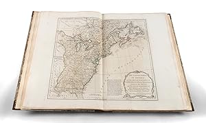
Sayer & Bennett's Catalogue of Prints for 1775. Reprint.
Language: English
Published by London, Holland Press, 1970
Seller: ANTIQUARIAT Franke BRUDDENBOOKS, L�beck, Germany
Seller rating 5 out of 5 stars

8�, Leinen. Condition: Gut. 150, 66 S., Gebundenes Buch mit Original-Schutzumschlag. Umschlag etwas berieben, innen sauber und gut erhalten Wir senden umgehend mit beiliegender MwSt.Rechnung. Sprache: Englisch Gewicht in Gramm: 320.
-

Complete Musashi: the Book of Five Rings and Other Works : Definitive New Translations of the Writings of Miyamoto Musashi - Japans Greatest Samurai
Seller: GreatBookPricesUK, Woodford Green, United Kingdom
Seller rating 5 out of 5 stars
US$ 14.85
US$ 20.11 shipping
Ships from United Kingdom to U.S.A.Quantity: 19 available
Add to basketCondition: New.
-
Paperback. Condition: New. Special order item direct from the distributor.
-
Complete Musashi: the Book of Five Rings and Other Works : Definitive New Translations of the Writings of Miyamoto Musashi - Japans Greatest Samurai
Seller: GreatBookPricesUK, Woodford Green, United Kingdom
Seller rating 5 out of 5 stars
US$ 17.83
US$ 20.11 shipping
Ships from United Kingdom to U.S.A.Quantity: 19 available
Add to basketCondition: As New. Unread book in perfect condition.
-

Sayer and Bennett's catalogue of prints for the year 1775
Published by London : The Holland Press, 1970
Facsimile Edition. Fine cloth copy in a very good, slightly edge-nicked and dust-dulled dust-wrapper. Remains particularly well-preserved overall; tight, bright, clean and strong. Physical description; Varied pagination. Subjects; Prints. Print catalogue. 1775 prints. 18th century printing. 3 Kg.
-

Facsimile Reprint. Good cloth copy in a good if somewhat edge-torn (with some loss) and dust-toned dust-wrapper, now mylar-sleeved. Remains quite well-preserved overall; tight, bright, clean and strong. Provenance; from the library of Roy and Nina Merley with the owner's bookplate. Physical description; 66 pages. Subjects; Sayer & Bennett's. Catalogue of Prints. 1775. 3 Kg.
-

Sayer and Bennett's catalogue of prints for the year 1775
Published by London : The Holland Press, 1970
Facsimile Edition. Fine cloth copy in a very good, slightly edge-nicked and dust-dulled dust-wrapper. Remains particularly well-preserved overall; tight, bright, clean and strong. Physical description; Varied pagination. Subjects; Prints. Print catalogue. 1775 prints. 18th century printing. 1 Kg.
-

Facsimile Reprint. Good cloth copy in a good if somewhat edge-torn (with some loss) and dust-toned dust-wrapper, now mylar-sleeved. Remains quite well-preserved overall; tight, bright, clean and strong. Provenance; from the library of Roy and Nina Merley with the owner's bookplate. Physical description; 66 pages. Subjects; Sayer & Bennett's. Catalogue of Prints. 1775. 1 Kg.
-

Sayer & Bennetts Catalogue Of Prints For 1775: Reprinted By The Holland Press In 1970
Published by The Holland Press, 1970
US$ 27.55
US$ 21.38 shipping
Ships from United Kingdom to U.S.A.Quantity: 1 available
Add to basketHardback. Condition: Very Good. Dust Jacket Condition: Very Good. Hardback facsimile reprint, 1970, with unclipped jacket. In overall very good used condition with only slight signs of age, handling and storage - dust jacket a touch rubbed (now protected); red cloth boards clean and crisp. Binding tight and appears little read. Internally clean, no annotation or inscriptions; text bright and clear throughout. Photographs available. Not an old library book.
-

Sayer and Bennett's Enlarged Catalogue of New and Valuable Prints, In Sets, or Single; also Useful and Correct Maps and Charts; Likewise Books of Architecture, Views of Antiquity, Drawing and Copy Books, &c. &c.
Published by The Holland Press, 1970
US$ 35.38
US$ 18.23 shipping
Ships from United Kingdom to U.S.A.Quantity: 1 available
Add to basketCondition: Good. This is an ex-library book and may have the usual library/used-book markings inside.This book has hardback covers. In good all round condition. No dust jacket. Please note the Image in this listing is a stock photo and may not match the covers of the actual item,200grams, ISBN:
-

The American Military Pocket Atlas; Being an Approved Collection of Correct Maps, Both General and Particular; of the British Colonies; Especially Tho
Language: English
Published by Creative Media Partners, LLC Sep 2021, 2021
ISBN 10: 1014324955 ISBN 13: 9781014324955
Taschenbuch. Condition: Neu. Neuware.
-

The American Military Pocket Atlas; Being an Approved Collection of Correct Maps, Both General and Particular; of the British Colonies; Especially Tho
Language: English
Published by Creative Media Partners, LLC Jul 2023, 2023
ISBN 10: 1020516704 ISBN 13: 9781020516702
Buch. Condition: Neu. Neuware - This atlas provides a detailed and accurate look at the British colonies in North America, including maps of areas likely to see military action. It is an essential resource for military leaders, historians, and anyone interested in the history of the American Revolution.
-

The American Military Pocket Atlas; Being an Approved Collection of Correct Maps; Both General and Particular; of the British Colonies; Especially Those Which Now Are; or Probably May Be the Theatre o
Seller: Ria Christie Collections, Uxbridge, United Kingdom
Seller rating 5 out of 5 stars
US$ 15.95
US$ 16.06 shipping
Ships from United Kingdom to U.S.A.Quantity: Over 20 available
Add to basketCondition: New. PRINT ON DEMAND Book; New; Fast Shipping from the UK. No. book.
-
Sayer and Bennett's enlarged catalogue of new and valuable prints, in sets, or single; also useful and correct Maps and Charts; likewise Books on Architecture, Views on Antiquity . For 1775. Reprint
Published by Holland press, London, 1970
Seller: Yushodo Co., Ltd., Fuefuki-shi, Yamanashi Pref., Japan
Association Member: ILAB
Seller rating 5 out of 5 stars
Hardcover. Condition: Good. Dust Jacket Condition: Fair. none. 150, 66p.
-

The American Military Pocket Atlas; Being an Approved Collection of Correct Maps, Both General and Particular; of the British Colonies; Especially Tho
Language: English
Published by Creative Media Partners, LLC, 2023
ISBN 10: 1020516704 ISBN 13: 9781020516702
HRD. Condition: New. New Book. Shipped from UK. THIS BOOK IS PRINTED ON DEMAND. Established seller since 2000.
-
The American Military Pocket Atlas; Being an Approved Collection of Correct Maps, Both General and Particular; of the British Colonies; Especially Those Which Now Are, or Probably May Be the Theatre of War; Taken Principally From the Actual Surveys And.
Seller: THE SAINT BOOKSTORE, Southport, United Kingdom
Seller rating 5 out of 5 stars
US$ 21.38
US$ 16.50 shipping
Ships from United Kingdom to U.S.A.Quantity: Over 20 available
Add to basketPaperback / softback. Condition: New. This item is printed on demand. New copy - Usually dispatched within 5-9 working days.
-
The American Military Pocket Atlas; Being an Approved Collection of Correct Maps, Both General and Particular; of the British Colonies; Especially Tho
Language: English
Published by Creative Media Partners, LLC, 2023
ISBN 10: 1020516704 ISBN 13: 9781020516702
Seller: PBShop.store UK, Fairford, GLOS, United Kingdom
Seller rating 5 out of 5 stars
US$ 35.02
US$ 4.41 shipping
Ships from United Kingdom to U.S.A.Quantity: Over 20 available
Add to basketHRD. Condition: New. New Book. Delivered from our UK warehouse in 4 to 14 business days. THIS BOOK IS PRINTED ON DEMAND. Established seller since 2000.
-
The West Indian Atlas or a General Description of the West Indies | Atlas des Indes Occidentales, ou Description G�o-Hydrographique des R�gions, des C�tes, des Isles, & des Mers, connues sous le nom d'Indes Occidentales, dans laquelle On trouve r�unis tous les D�tails G�ographiques & Nautiques qui appartiennent � cette Partie de l'Amerique, & dont le plus grand nombre n'a point encore paru.
Published by Thomas Jefferys / Sayer & Bennett, 1777
Seller: Barry Lawrence Ruderman, La Jolla, CA, U.S.A.
Seller rating 5 out of 5 stars
Hardcover. Condition: vg. Transmitting an Ambitious British Hydrographic Syntheses of the Caribbean to a French-language Atlantic World on the Eve of France s Intervention in the American RevolutionRare French edition of Jeffery's West Indi. Folio. Bound to style in handsome antique half calf and pastepaper-covered boards, green leather spine label, raised bands. Vellum-tipped corners. Inconspicuous occasional dust soil. Small paper repair to map index leaf at gutter margin (printed area unaffected). Letterpress title page, 6, [2, map index], double-page engraved pictorial title (in English) and 39 (36 double-page) engraved maps. Transmitting an Ambitious British Hydrographic Syntheses of the Caribbean to a French-language Atlantic World on the Eve of France s Intervention in the American RevolutionRare French edition of Jeffery's West Indian atlas. The original English edition of the atlas was issued in 1775. The present French version has a new French letterpress title page and preliminary text also in French. Includes detailed charts of the Canary Islands, Bermuda, Bahamas, Florida, Mexico, Cuba, Jamaica, St. Domingo, Costa Rica, Panama, Guadaloupe, Martinique, Barbados, Grenada, Tobago, Curacao and others.Jefferys s West Indian Atlas was first issued in English in 1775 by Sayer and Bennett, who had acquired Jefferys s materials after his death. The heart of the atlas is the sixteen-sheet complete chart of the West Indies with index map, supplemented by route charts from Britain through the Atlantic islands and individual island charts. The 1777 French edition, Atlas des Indes Occidentales, published in Paris by Julien, is rarer than the English version and is separately noted by Phillips under entry no. 3943. Although dependent on the 1775 English atlas, it is far more than a derivative curiosity: this atlas transmitted one of the most ambitious British hydrographic syntheses of the Caribbean to a French-language Atlantic world on the eve of France s intervention in the American Revolution. Of particular carto-bibliographical interest are the sheets extending beyond the islands to the Gulf and Spanish mainland, including the coast of West Florida and Louisiana and the Gulf of Mexico, and the Coast of New Spain and Bay of Honduras sheets, all part of the atlas s wider vision of the Caribbean as a connected maritime system rather than a simple island group.The maps are as follows:A chart of the British Channel . . . 1775.A chart of the Atlantic Ocean . . . 1775.Chart of the A ores (Hawks) Islands, called also Flemish and Western islands from m d Anville with several additions. 1775. Insets: The road of Fayal, with Porto Pin. A chart of the A ores islands drawn . . . by mon d Eveux de Fleurieu . . . 1772. The roads of Punta Delgada and Villa Franca, in the isle of St. Miguel.A chart of the Maderas and Canary Islands. From the draughts . . . of Cap George Glas . . . 1775. Insets: Plan of El Rio Harbour. Plan of Puerto de Naos and Puerto Cavallo.The Cape Verd islands . . . By Mons D Apr s de Mannevillette . . . 1775. Inset: Praya bay. A view of Praya bay.The Bermudas or Summer s Islands. From a survey by C. Lempriere . . . 1775.An index map of the following sixteen sheets, being a compleat chart of the West Indies . . . 1775.The western coast of Louisiana and the coast of New Leon . . . 1775. Book.
-
[Plano of San Juan, Puerto Rico] A Plan of the Forts and Harbour of San Juan Portorico
Published by London, 1794
Seller: Bolivar Old Prints Anticuario, Barcelona, B, Spain
Seller rating 5 out of 5 stars
Map
Sin Encuadernar. Condition: Bueno. [English description below] Raro mapa de San Juan, Puerto Rico, publicado por Sayer y Bennett en 1794. Esta es la segunda edici�n del mapa, siendo la primera publicada por Jefferys en 1762 (con el n�mero de p�gina 90; nuestra edici�n, en cambio, presenta el n�mero 40 en la esquina superior derecha). Se trata de uno de los primeros planos existentes de la capital de la isla. El mapa se centra en el sistema de defensa del puerto, en una �poca en la que la isla era disputada entre Espa�a y el Reino Unido. Muestra la ciudad amurallada de San Juan con sus diferentes entradas: Santiago, San Juan y San Justo. Al norte limita con el Fuerte de la Perla y al oeste con el Castillo San Felipe del Morro. M�s al oeste, cerca de la Isla de Cabra, se encuentra el Fort�n San Juan de la Cruz, tambi�n conocido como El Ca�uelo. Al otro lado de la ciudad se erige el Fuerte San Antonio, protegiendo el Puente de San Antonio, que conectaba San Juan con la Isla de Puerto Rico. El mapa se encuentra en excelente estado de conservaci�n, con una liviana descoloraci�n del papel en la parte inferior derecha, fuera del grabado. ---------------------------------------- Rare chart of San Juan, Puerto Rico, published by Sayer and Bennett in 1794. This is the second edition of that map, with the first edition published by Jefferys in 1762 (bearing page number 90). Our edition bears page number 40 in the upper right corner. It is one of the earliest obtainable plans of the capital of the island. The chart focuses on the defense system of the port, at a time when the island was heavily disputed between Spain and the United Kingdom. It shows the walled city of San Juan, with its different gates (Santiago, San Juan, and San Justo). It is bordered north by the Fuerte de la Perla and west by Castillo San Felipe del Morro. Further west, close to the Isla de Cabra, can be seen the fort Fort�n San Juan de la Cruz, also called El Ca�uelo. On the other side of the city is Fort San Antonio, protecting the Puente de San Antonio, which linked San Juan with the Island of Puerto Rico. Excellent condition, with a slight discoloration of the paper in the lower right margin, not affecting the image. ENG. Excellent.
-
The American Atlas, or a Geographical Description of the Whole Continent of America.
Published by Robert Sayer / John Bennett / Thomas Jefferys, 1782
Seller: Barry Lawrence Ruderman, La Jolla, CA, U.S.A.
Seller rating 5 out of 5 stars
Hardcover. Condition: VG. The First National Atlas of the United States. The Exceptionally Rare 1783 Edition of Jeffery s American Atlas. A virtually-unknown edition of Jefferys's essential American Atlas, the updated 1783 edition, Folio. Half antique calf over contemporary marbled boards, rebacked and recornered to style. Spine in eight compartments, separated with raised bands, gilt-lettered title piece in the second. Gilt-lettered red morocco title piece onlaid to front cover: UNITED STATES ATLAS . Marbled endpapers. Title, index, and 23 engraved maps on 30 sheets, many of which are folding and with original outline hand-color. The map sheets uniformly number-stamped on versos at upper fore-edge corners. A few minor faults expertly mended. The First National Atlas of the United States. The Exceptionally Rare 1783 Edition of Jeffery s American Atlas. A virtually-unknown edition of Jefferys's essential American Atlas, the updated 1783 edition, which, crucially, illustrates the latest geopolitical transformation resulting from the Treaty of Paris, declaring the establishment of the United States in several significant maps of North America - and therefore standing as the first national atlas of the United States. Thomas Jefferys' American Atlas was one of the four great atlases of the North American Colonies available during the Revolution - along with Faden's North American Atlas, Des Barres' Atlantic Neptune, and Jefferys and Sayer's A General Topography of North America - and it was certainly the most actively published and used. Jeffreys was the leading British cartographer of his day, becoming Geographer to the King by 1761. He started producing maps relating to North American circa 1750, when he issued a series of important maps of the British American colonies. Although Jefferys died in 1771, the importance of his American Atlas can be seen in how it continued to be updated and issued by Sayer and Bennett. According to Pritchard and Taliaferro: "That Sayer and Bennett were publishing atlases under Jefferys's name five years after his death indicated the late map publisher's continuing influence in the market" - Degrees of Latitude, page 211. While the 1776 edition of the American Atlas was THE atlas of the American Revolution, having been one of the primary cartographic references for American, British, and French military officials during the conflict, the triumph of the American cause would be first enshrined in the maps of this very rare 1783 edition. This Edition and Its Maps This edition of the American Atlas is of the greatest interest, as it is the first national atlas issued after the cessation of hostilities to proclaim the existence of the United States. Although the title page is dated 1782, in actuality it was almost certainly issued after the January 20, 1783 iteration of the Treaty of Paris, but before August 15, 1783. The three key maps are Stevens & Tree's numbers 4(e) [map 1]; 49(h) [maps 5-6]; and 51(d) [map 7], all of which rank among the very first English-language maps to include "United States" (or some allusion thereto) in the title. Map 1. A Chart of North and South America, Including the Atlantic and Pacific Oceans. According to the Preliminary Articles of Peace, Signed at Versailles, 20, Jany. 1783. Imprint: Sayer & Bennett, 10 June, 1775. Dated by Stevens & Tree: 1775-[1783]. Maps 5-6. A New and Correct Map of North America, with the West India Islands. Divided according to the Preliminary Articles of Peace, Signed at Versailles, 20 Jan. 1783. wherein are particularly Distinguised, The United States, & the Several Provinces and Colonies, which Compose the British Empire. 1783. As described by Stevens & Tr. Book.
-
The American Military Pocket Atlas
Published by [1776]., 1776
Seller: Maggs Bros. Ltd ABA, ILAB, PBFA, London, United Kingdom
Association Member: ABA ILAB PBFA
Seller rating 5 out of 5 stars
Map First Edition
US$ 17,261.10
US$ 36.20 shipping
Ships from United Kingdom to U.S.A.Quantity: 1 available
Add to basketbeing an approved collection of�correct maps,�both general and�particular, of the�British Colonies,� especially those which are now, or probably may be, the theatre of war. First edition. 6 folding engraved maps, hand-coloured in outline. 8vo. Contemporary quarter calf over marbled boards, maps soiled�& frayed at�edges,�some discoloration�at folds, rebacked. London, Printed for R. Sayer and J. Bennett,� � � Published at the behest of Governor George Pownall, the advertisement clarifies its purpose: "Surveys and Topographical Charts being fit only for a Library, such maps as an Officer may take with him into the Field have been much wanted. The following Collection forms a Portable Atlas of North America, calculated in its Bulk and Price suit the Pockets of Officers of all Ranks." � The six maps here represent a distillation of what the British high command saw as the most pertinent topographical information for soldiers and, being issued at the war's outset, provides keen insight into how the British envisioned the war unfolding. As with this copy, the atlas was usually folded down to octavo size. Not quite small enough to fit in a pocket, it was generally carried in a soldier's holster and soon was referred to as the holster atlas. The six maps are: 1. DUNN (Samuel). "North America, as Divided Amongst the European Powers. By Samuel Dunn, Mathematician." Engraved map, hand-coloured in outline measuring 13 1/2 by 18 1/4 inches. London, printed for Robt. Sayer, Jan. 10, 1774. Engraved for Dunn's A New Atlas , London, 1774. 2. DUNN (Samuel). "A Compleat Map of the West Indies, Containing the Coasts of Florida, Louisiana, New Spain, and Terra Firma: with all the Islands." Engraved map, hand-coloured in outline measuring 13 1/4 x 18 1/2 inches). London, Robt. Sayer, Jan. 10, 1774. Engraved for Dunn's A New Atlas London, 1774. 3. "A General Map of the Northern British Colonies in America. Which comprehends the province of Quebec, the Government of Newfoundland, Nova-Scotia, New-England and New-York. From the Maps Published by the Admiralty and Board of Trade, Regulated by the Astronomic and Trigonometric Observations of Major Holland and corrected from Governor Pownall's Late Map 1776." Engraved map, hand-coloured in outline measuring 20 3/4 by 26 3/4 inches. London, Robt. Sayer & Jno. Bennet, Aug. 14, 1776. A very good copy, here in its first state. The map also issued separately and was re-issued in 1788 with an updated title. 4. EVANS (Lewis). "A General Map of the Middle British Colonies in America. containing Virginia, Maryland, the Delaware Counties, Pennsylvania and New Jersey. with the addition of New York, and the greatest part of New England, as also of the bordering parts of the Province of Quebec, improved from several surveys made after the late war, and corrected from Governor Pownall's Late Map 1776." Engraved map, hand-coloured in outline measuring 20 1/2 by 26 3/4 inches. London, R. Sayer & J. Bennet, Oct. 15, 1776. Based on the 1755 Lewis Evans map, with subsequent corrections. 5. ROMANS (Bernard). "A general map of the Southern British Colonies, in America. comprehending North and South Carolina, Georgia, East and West Florida, with the neighbouring Indian countries. From the modern surveys of Engineer de Brahm, Capt. Collet, Mouzon & others; and from the large hydrographical survey of the coasts of East and West Florida. By B. Romans." Engraved map, hand-coloured in outline measuring 20 3/4 by 25 5/8 inches. London, R.Sayer & J. Bennett [sic.], 15 October. 1776. Based on charts and maps by Roman and others. 6. BRASSIER (William Furness). "A Survey of Lake Champlain including Lake George, Crown Point and St. John, Surveyed by order of . Sr. Jeffery Amherst . by William Brassier, draughtsman. 1762." Engraved map, hand-coloured in outline measuring 29 1/8 by 21 5/8 inches. London, Robt. Sayer & Jno. Bennet, 5 Aug., 1776. Also issued as the first separately published map of Lake Champlain, this chart was based on a s.
-
![Seller image for The American military pocket atlas; being an approved collection of correct maps, both general and particular; of the British colonies; especially those which now are, or probably may be the theatre of war; taken principally from the actual surveys and judicious observations of engineers De Brahm and Romans; Cook, Jackson, and Collet; 1776 [LeatherBound] for sale by True World of Books](https://pictures.abebooks.com/inventory/md/md31657234871.jpg)
LeatherBound. Condition: New. BOOKS ARE EXEMPT FROM IMPORT DUTIES AND TARIFFS; NO EXTRA CHARGES APPLY. LeatherBound edition. Condition: New. Reprinted from 1776 edition. Leather Binding on Spine and Corners with Golden leaf printing on spine. Bound in genuine leather with Satin ribbon page markers and Spine with raised gilt bands. A perfect gift for your loved ones. Pages: 35 NO changes have been made to the original text. This is NOT a retyped or an ocr'd reprint. Illustrations, Index, if any, are included in black and white. Each page is checked manually before printing. As this print on demand book is reprinted from a very old book, there could be some missing or flawed pages, but we always try to make the book as complete as possible. Fold-outs, if any, are not part of the book. If the original book was published in multiple volumes then this reprint is of only one volume, not the whole set. Sewing binding for longer life, where the book block is actually sewn (smythe sewn/section sewn) with thread before binding which results in a more durable type of binding. Pages: 35 Robert Sayer and John Bennett (Firm).
-
The American Military Pocket Atlas; Being an Approved Collection of Correct Maps, Both General and Particular; of the British Colonies; Especially Those Which Now Are, or Probably May Be the Theatre of War; Taken Principally From the Actual Surveys And.
Seller: THE SAINT BOOKSTORE, Southport, United Kingdom
Seller rating 5 out of 5 stars
US$ 39.44
US$ 17.46 shipping
Ships from United Kingdom to U.S.A.Quantity: Over 20 available
Add to basketHardback. Condition: New. This item is printed on demand. New copy - Usually dispatched within 5-9 working days.
-

A Chart of the Nicobar Islands
Published by London, 1778
Seller: Clive A. Burden Ltd., Chalfont St. Giles, BUCKS, United Kingdom
Seller rating 5 out of 5 stars
Map
US$ 310.70
US$ 29.70 shipping
Ships from United Kingdom to U.S.A.Quantity: 1 available
Add to basketNo binding. 540 x 370 mm., in fine early wash colour and in good condition. Robert Sayer was active from 1745 and was joined in partnership by John Bennett in 1774. Their early works were derived from maps acquired from the late Thomas Jefferys. One of their most significant productions was the 'East India Pilot' which was advertised in 1775 as being 'in great forwardness for publication'. This chart of the Nicobar Islands bears an inset of "A particular Plan of the Harbour Comprized between the Isles Nacaveri, Souri & Tricutte". Shirley BL Atlases M.Say-3a no. 62; NMM 417 no. 29.
-
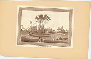
A View of Paddington Green.
Published by London ., 1783
Seller: Robert Frew Ltd. ABA ILAB, London, United Kingdom
Association Member: ABA ILAB PBFA
Seller rating 5 out of 5 stars
Art / Print / Poster
US$ 345.22
US$ 13.41 shipping
Ships from United Kingdom to U.S.A.Quantity: 1 available
Add to basketOriginal uncoloured mezzotint laid down on to card. Print dimensions 25 x 35 cm. A very good example. The green is the old centre of Paddington, where an ancient manor house stood until 1824. Today all that is left of the affluent village built around the green are an early-19th century church and two 18th-century homes on the east side of the green. From a series of views first published by R. Sayer and J. Bennett in 1783.
-
![Seller image for Geographia antiqua delineata ; or, Antient geography, exhibited in a set of thirty-one maps comprehending all the several states of Greece, and the numerous parts of the Roman Empire, contained in the Greek and Latin classics . to which is added, a map of the places mentioned in the Old and New Testament . [cartographic material] 1775 [LeatherBound] for sale by True World of Books](https://pictures.abebooks.com/inventory/md/md31533285587.jpg)
LeatherBound. Condition: New. BOOKS ARE EXEMPT FROM IMPORT DUTIES AND TARIFFS; NO EXTRA CHARGES APPLY. LeatherBound edition. Condition: New. Reprinted from 1775 edition. Leather Binding on Spine and Corners with Golden leaf printing on spine. NO changes have been made to the original text. This is NOT a retyped or an ocr'd reprint. Illustrations, Index, if any, are included in black and white. Each page is checked manually before printing. Pages: 130 As this print on demand book is reprinted from a very old book, there could be some missing or flawed pages, but we always try to make the book as complete as possible. Fold-outs, if any, are not part of the book. If the original book was published in multiple volumes then this reprint is of only one volume, not the whole set. Sewing binding for longer life, where the book block is actually sewn (smythe sewn/section sewn) with thread before binding which results in a more durable type of binding. Pages: 130 Language: English.
-
A Chart of the Straits of Magellan. Enlarged from the Chart Published at Madrid in 1769 by Don Juan de la Cruz Cano y Olmedilla.
Published by R. Sayer and J. Bennett, London, 1775
Seller: Jeffrey H. Marks, Rare Books, ABAA, Rochester, NY, U.S.A.
Seller rating 5 out of 5 stars
Improved from the Observations and Surveys of Captns. Byron, Wallis and Carteret compared with those of Monsr. de Bougainville. Engraved map with old outline color. 20-1/4 x 27 " (image). Two coin-sized unobtrusive brown spots near the top margin; very attractive. Inset map: A Chart of Magellania with Falkland's Islands.
-

Damon and Pastora
Published by R. Sayer & J. Bennett, London, 1783
Seller: Donald A. Heald Rare Books (ABAA), New York, NY, U.S.A.
Seller rating 5 out of 5 stars
Art / Print / Poster
Mezzotint, collection mark on verso, tipped onto early mount. (Expert small repairs to upper corners). A charming anonymous image from the collection of Frederic R. Halsey (1847-1918), 'un des principaux collectionneurs de son �poque � New York' (Lugt 1308) The image (of a fashionably-dressed young lady reclining by a brook being approached by a young gentleman) is explained by the engraved verse (by 'Mr. Nicholl') in the title area beneath the image: Alone by the side of a murmuring rill / That lav'd the gay foot of a primrosy hill / Pastora beneath a broad poplar was laid / When Damon in extasy enter'd the Shade / He sigh'd & he swore by the pow'rs overhead / If she'd bless him to day, to morrow he'd wed.


![Seller image for [Plano of San Juan, Puerto Rico] A Plan of the Forts and Harbour of San Juan Portorico for sale by Bolivar Old Prints Anticuario](https://pictures.abebooks.com/inventory/md/md32076909625.jpg)