Order Total (1 Item Items):
Shipping Destination:

Seutter Georg Matthaus (19 results)
Skip to main search results
Search filters
Product Type
- All Product Types
- Books (12)
- Magazines & Periodicals (No further results match this refinement)
- Comics (No further results match this refinement)
- Sheet Music (No further results match this refinement)
- Art, Prints & Posters (5)
- Photographs (No further results match this refinement)
- Maps (2)
- Manuscripts & Paper Collectibles (No further results match this refinement)
Condition Learn more
- New (No further results match this refinement)
- As New, Fine or Near Fine (No further results match this refinement)
- Very Good or Good (7)
- Fair or Poor (No further results match this refinement)
- As Described (12)
Binding
Collectible Attributes
- First Edition (No further results match this refinement)
- Signed (No further results match this refinement)
- Dust Jacket (1)
- Seller-Supplied Images (14)
- Not Print on Demand (19)
Language (1)
Price
- Any Price
- Under US$ 25 (No further results match this refinement)
- US$ 25 to US$ 50 (No further results match this refinement)
- Over US$ 50
Free Shipping
Seller Location
Seller Rating
-
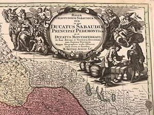
Regiae Celsitudinis Sabaudicae status in quo Ducatus Sabaudiae Principat Pedemontium et Ducatus Montisferrati.
Published by (Augsburg), sine data (1730 circa),, 1730
Seller: Libreria Antiquaria Pregliasco, Torino, TO, Italy
Seller rating 5 out of 5 stars

Condition: molto buono. Incisione in rame mm 500 x 570 arricchita da bella coloritura coeva. Titolo inciso entro grande ed elaborato cartiglio in bianco nero, raffigurante una scena mercantile, posto nella porzione superiore destra del rame. Nell'angolo in basso a destra sono riportate le scale grafiche "Milliaria Germanica communia 15 in uno gradu" e "Miliaria Italica communia". La carta ripropone, modificandone il cartiglio, quella di J.B. Homann, del quale Seutter era stato collaboratore. Matthia Seutter di Augsburg (1678-1757) fu allievo di Homann e ne continu� l'attivit� come cartografo, incisore ed editore di atlanti. Carta geografica dei territori del Piemonte e della Savoia Bell'esemplare con qualche piccolo strappetto abilmente restaurato nel margine superiore bianco. G. Aliprandi, Le grandi Alpi ( 2005), p. 288 (v. 1); F. Barrera, Il Piemonte nella cartografia del Settecento, n. 30 ; Torino e il suo orizzonte, n. 107 e n. 123. Book.
-

Insula et Regnum Sardinia.
Published by Augsburg 1730 ca., 1730
Seller: Libreria Antiquaria Pregliasco, Torino, TO, Italy
Seller rating 5 out of 5 stars
Condition: molto buono. Incisione originale su rame, mm 500 x 580 e margini, abilmente colorata da mano coeva. Bella e raffinata carta geografica della Sardegna tratta dall'Atlas Novus del Seutter pubblicato ad Augsburg nel 1730 ca In alto a sinistra il titolo entro importante cartiglio animato da personaggi, flora e fauna di carattere allegorico. In basso altri due cartigli con le scale metriche e lo stemma di Vittorio Amedeo II di Savoia, nel quale � inserito anche lo stemma sardo. La mappa � basata sulla medesima rappresentazione dell'isola disegnata dal Coronelli nel 1680. Bell'esemplare in bella colorazione d'epoca. Piloni n. LXVII. Book.
-
Atlas Minor.
Published by Augsburg: [c1744]., 1744
Seller: D & E LAKE LTD. (ABAC/ILAB), Toronto, ON, Canada
Seller rating 2 out of 5 stars

Soft cover. Condition: Very Good. oblong folio. [pp. 34]. hand-coloured engraved title with an elaborate allegorical border of the Continents, Empire and the Gods by Martin Gottfrid Crophius after Jacob Christoph Weyerman & 65 hand-coloured engraved maps by Tobias Conrad Lotter, Albrecht Carl Seutter, & Andreas Silbereisen after Matth�us Seutter & Albrecht Carl Seutter. woodcut tailpiece. contemporary limp calf (rubbed & cockled, edges chipped, staining to portion of last 4 maps, scattered foxing & some marginal dampstaining & minor tears, several tiny wormholes in first few leaves). An attractive atlas by one of the leading eighteenth century German map publishers and engravers. Including maps of the world, North America, South America, Asia, Africa, Russia, the Turkish Empire, Southern Russia and the Crimea, the Holy Land, and various countries and regions of Europe. The map of Genoa, by Matth�us Petter L�inpacher, does not appear in the index. cfNordenski�ld 283 (67 maps; 4 not listed in index). cfPhillips, Atlases, 3494 (68 maps: 4 not listed in index).
-

Karte von Dalmatien, Kroatien, Slawonien, Bosnien, Serbien und Istrien. Originaltitel: Nova et Accurata Tabula Regnorum et Provinciarum Dalmatiae, Croatiae, Sclavoniae, Bosniae, Serviae, Istriae et Republicae Ragusanae, cum finitimis regionibus Studio et Impensis Matthaei Seutteri Sacrae Caesareae et Regacrae Catholicae Maisestatis geographi edita Augustae Vindelicorum. Kolorierter Kupferstich. Gerahmt, unter Glas.
Published by Augsburg., 1709
Seller: Galerie Hentrich & Shrivastava, Berlin, Germany
Seller rating 5 out of 5 stars
Plattengr��e ca 50 x 57 cm / gerahmt 55 x 64 cm. Geringf�gig stockfleckig, sonst sch�nes wohlerhaltenes Exemplar. / Die Karte stellt Slawonien und Kroatien innerhalb ihrer mittelalterlichen Grenzen dar, sowie Dalmatien innerhalb der Grenze, die, im Einklang mit den venezianischen Vorlagen, ganz Herzegowina und einen Teil von Montenegro darstellt. Auf dem Gebiet Slawoniens sind die mittelalterlichen Gespanschaften und die Territorien einzelner St�dte eingezeichnet. In der unteren rechten Ecke befinden sich die Wappen Dalmatiens, Kroatiens, Slawoniens, Bosniens (Rama) und Serbiens. Der Kartentitel befindet sich in der unteren linken Ecke in einem einfachen Rechteck, der von Milit�rsymbolen und allegorischen Gestalten umrandet ist. Der Kartenma�stab ist in deutschen (Milliaria Germanica) und italienischen (Milliaria Italica) Meilen ausgedr�ckt. / GEORG MATTH�US SEUTTER (1678-1757) deutscher Kartograph, Geograph und Kartenherausgeber. Er war ein Sch�ler von Johann Baptist Homann und sp�ter der Hauptkonkurrent von Homanns Erben. In Augsburg begann er als Graphiker zu arbeiten. Seutter hat seine Karten haupts�chlich selber graviert. Andere K�nstler haben die Karten dekoriert. Neben den Dekorierungen befinden sich oft ihre Unterschriften. In Seutters Werkstatt entstanden ca. 500 Karten. Obwohl seine Karten jenen von Homann sehr �hnlich waren, haben sie nie Homanns Kunstwert erreicht. Die bekanntesten Werke Seutters sind: "Atlas Geographicus" aus dem Jahre 1725, "Atlas novus indicibus instructus" herausgegeben in Wien um 1730, "Grosser Atlas" aus dem Jahre 1734 und "Atlas minor praecipua orbis terrarum imperia" aus dem Jahre 1744. Sprache: deutsch.
-
Holsatiae Mappa universalis in suos Ducatus nimirum Holsatiam in Specie Dithmarsiam, Stormariam, Wagriam, accurate distincta Cura et impensis. -
Published by Augsburg: Seutter [um ]. -, 1750
Seller: Antiquariat Tautenhahn, L�beck, Germany
Association Member: GIAQ ILAB VDA
Seller rating 5 out of 5 stars
Art / Print / Poster
Kupferstich 49,5 x 58 cm Bildgr��e, 52 x 60 cm Blattgr��e. Das Herzogtum Holstein, am oberen Bildrand das Herzogtum Schleswig mit Eiderstedt und der Eckernf�rder Bucht. Am unteren Bildrand der Elblauf. In der rechten unteren Ecke eine fig�rliche Kartusche und dem Wappen von Holstein. Unten links eine kleine Kartusche mit Meilenanzeiger, Figuren und den Wappen von Dithmarschen, Stormarn und Wagrien. Zart grenzkoloriert. - Georg Matth�us Seutter, 1678-1757, Geograph, Kartograph, Graveur und Herausgeber in Augsburg. - Die r�ckseitig verst�rkte Mittelfalte zart gebr�unt, das Blatt leicht fingerfleckig. In der rechten Blatth�lfte Abklatsch der Grenzlinien von der linken Seite.
-

Dominium venetum cum adjacentibus Mediolan. Mantuano, Mutinensi, Mirandolano, Parmensi, Placentino Ducatibus
Published by Augusta, 1740 circa, 1740
Seller: TABERNA LIBRARIA - ALAI - ILAB, Pistoia, PT, Italy
Seller rating 5 out of 5 stars
Grande carta inc. in rame, mm.500x590 alla battuta, ampi marg. bianchi. Fastoso cartiglio animato contenente il titolo. Confini col. all'epoca. La carta presenta aloni di muffa e tenui ombreggiature (pi� visibili al verso) per circa met� del foglio. Es. comunque compless. ben conservato, a pieni margini.
-
Ducatus mediolanensis cum adjacentibus Principat et Dominiis
Published by Augusta, 1740 circa, 1740
Seller: TABERNA LIBRARIA - ALAI - ILAB, Pistoia, PT, Italy
Seller rating 5 out of 5 stars
Grande carta inc. in rame, mm.490x580 alla battuta, ampi marg. bianchi. Fastoso cartiglio animato contenente il titolo. Confini vivacemente col. all'epoca. Tenuissimi aloni in prossimit� dell'angolo sup. sin. peraltro fresca nitida impressione.
-

Holsatiae Mappa universalis in suos Ducatus nimirum Holsatiam in Specie Dithmarsiam, Stormariam, Wagriam, accurate distincta Cura et impensis. -
Published by Augsburg: Seutter [um ]. -, 1750
Seller: Antiquariat Tautenhahn, L�beck, Germany
Association Member: GIAQ ILAB VDA
Seller rating 5 out of 5 stars
Art / Print / Poster
Altkolorierter Kupferstich 49,5 x 58 cm Bildgr��e, 53 x 61 cm Blattgr��e. Das Herzogtum Holstein, am oberen Bildrand das Herzogtum Schleswig mit Eiderstedt und der Eckernf�rder Bucht. Am unteren Bildrand der Elblauf. In der rechten unteren Ecke eine fig�rliche Kartusche und dem Wappen von Holstein. Unten links eine kleine Kartusche mit Meilenanzeiger, Figuren und den Wappen von Dithmarschen, Stormarn und Wagrien. Die holsteinischen Gebiete fl�chig koloriert, au�erhalb davon grenzkoloriert. - Georg Matth�us Seutter 1678-1757 Geograph, Kartograph, Graveur und Verleger in Augsburg. - R�ckseitig Spuren einer fr�heren Rahmung. Das Blatt komplett minimal stockfleckig, der Druck klar.
-
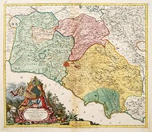
Novissima Et Accuratissima Delineatio Status Ecclesiae Et Magni Ducatus Hetruriae.
Published by Augsburg, August Vindel, c. 1730,, 1730
Seller: TABERNA LIBRARIA - ALAI - ILAB, Pistoia, PT, Italy
Seller rating 5 out of 5 stars
Incisione su rame, mm.500x570 alla battuta, margini bianchi integri, magnifica coloritura coeva, tit. entro cartiglio elaborato con stemmi. Piegatura centrale. Bella conservazione.
-
Gli Stati DEL SOMMO PONTEFICE chiamati IL PARTIMONIO DI ST PIETRO Rome.
Published by Ausberg. [c.1740], 1740
Seller: Peter Harrington. ABA/ ILAB., London, United Kingdom
Association Member: ABA ILAB PBFA
Seller rating 5 out of 5 stars
US$ 611.89
US$ 29.04 shipping
Ships from United Kingdom to U.S.A.Quantity: 1 available
Add to basketA splendid map of the area surrounding Rome, with regions clearly delineated. Magnificent baroque cartouche with title surrounded by ornate shell, in a woodland landscape whilst above,there is a regal tent containing a gold crown guarded by cherubs. Copper engraving. Fine condition. Slight discolouration to the central fold. Original colour. Size: 56 x 48 cm.
-

Representation la plus nouvelle et exacte de l'Ile Martinique.
Published by Ausberg. c.1750, 1750
Seller: Peter Harrington. ABA/ ILAB., London, United Kingdom
Association Member: ABA ILAB PBFA
Seller rating 5 out of 5 stars
US$ 679.88
US$ 29.04 shipping
Ships from United Kingdom to U.S.A.Quantity: 1 available
Add to basketA truly superb and very beautiful large scale map of this idyllic French Caribbean island with an extremely decorative cartouche that depicts the native islanders meeting and trading with Europeans. The cartouche is uncoloured. Compass roses and rhumb lines abound. This map displays all of Seutter's extensive engraving skills. Copper engraving. Overall in excellent condition but small stain (approx 0.5 x 2cm) left-hand bottom edge Original colour. Size: 56.2 x 49 cm.
-
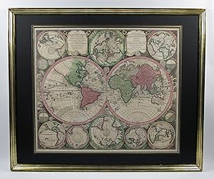
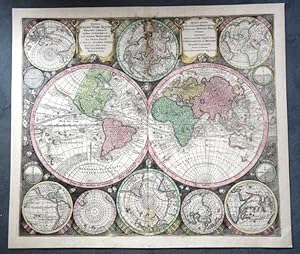
Weltkarte, 4 Kontinentkarten und Himmelskarte.
Published by Augsburg, G.M. Seutter um, 1730
Seller: Antiquariat F. Neidhardt, B�blingen, Germany
Seller rating 5 out of 5 stars
Map
Uniformer Satz 6 altkolorierter Kupferstichkarten, Abbildungen ca. 50 x 58 cm. Unter Glas gerahmt, 68 x 80 cm. Sehr dekorative Karten im Verlagskolorit und in guten Abz�gen. Die Welt- und Himmelskarte mit je 2 Hemisph�ren und 12 bzw. 7 weiteren Darstellungen im Rund wie Polprojektionen und Sonnensystem nach Ptolem�us, Kopernikus und Tycho Brahe. Die Himmels- und Kontinentkarten verf�gen zudem �ber je 1-2 fig�rliche, dekorative Titelkartuschen. Aus "Atlas novus sive tabulae geographicae totius orbis".- G.M. Seutter (1678-1757) lernte in der Homann'schen Offizin, bevor er 1707 nach Augsburg ging und dort einen eigenen, sp�ter sehr erfolgreichen Verlag gr�ndete.- Die Himmelskarte und Europa mit kleinem hinterlegten Einriss, Bugfalten teils minimal ge�ffnet, Amerika und Europa mit zwei bzw. drei schwachen, unauff�lligen Braunflecken in der Abbildung, Himmelskarte mit Br�unung im Rand, teils minimal fingerfleckig. Das feste Papier sauber und insgesamt sehr sch�n erhalten. Fachm�nnisch gerahmt in Echtgoldleisten unter schwarzen Zierpassepartouts und Glas in Museumsqualit�t.- Sandler S. 14f. Phillips/Le Gear 593. Warner S. 245, 1a (zur Himmelskarte).
-
Bruxeliae (Brussels)
Published by Augsburg
Seller: Arader Galleries of Philadelphia, PA, Philadelphia, PA, U.S.A.
Seller rating 4 out of 5 stars

N/A. Condition: Good. Dust Jacket Condition: N/A. A large plan of the city and surrounding countryside from Seutter's atlas of city plans, circa 1741. Beneath the plan is an uncolored view of Brussels, with landmarks noted and--curiously--a gallows in the foreground. Copperplate engraving with full original color. Some faint soiling and foxing; minor signs of wear, overall a good example. Sheet size: 21 1/4 x 24 3/8". Inventory#: p196pmat. 0.
-
WELTKARTE Originaltitel :"Globi Terr-Aquel Statione variante. " Per coluros tropicorum per ambos Polos.
Published by Augsbourg um, 1735
Seller: Graphica-Antiqua, Stich-Galerie Osvald, St.Gallen, SG, Switzerland
Seller rating 4 out of 5 stars
US$ 1,931.57
US$ 11.52 shipping
Ships from Switzerland to U.S.A.Quantity: 1 available
Add to basketKupferstich, altkoloriert Blattgr�sse 50.5x59.5cm; Bildgr�sse 54.5x62.5cm Mittelfalz, Wasserflecken some waterstaines,
-
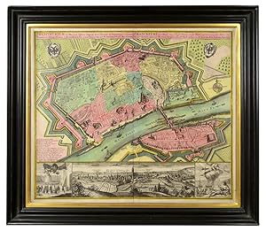
Frankfurt. Plan-Prospekt.
Published by Seutter Augsburg ca, 1730
Seller: Shapero Rare Books, London, United Kingdom
Association Member: ABA ILAB PBFA
Seller rating 4 out of 5 stars
Map
US$ 2,379.59
US$ 19.80 shipping
Ships from United Kingdom to U.S.A.Quantity: 1 available
Add to basketDouble-page engraved plan (49 x 57 cm) with full contemporary body wash colour. Framed dimensions: 63 x 70 cm. Fine plan of Frankfurt in full contemporary colour, with a panoramic view of the city and the river Main. Seutter's plan celebrates Frankfurt as an Imperial Free City under the Holy Roman Empire, famed for its status as a flourishing trading city. Its trading success is suggested by Frankfurt am Main's row of busy ports and the large docked ship entering Sachsenhausen across the river. It is also overtly signalled by the right hand panel of the prospect showing Hermes, the Greek god of trade and commerce, showering an allegorical depiction of the city with riches. Meanwhile Frankfurt's might is emphasised by the city walls and fortifications, and by the left hand panel of the prospect, depicting the German imperial eagle hovering commandingly above troops. The plan's alphabetical key identifies the city's key sites, the majority of which are churches. Meanwhile the city's outskirts are designated as rich agricultural land, both in the plan itself and central panel of the prospect. Seutter (1647-1756) was one of the most important and prolific German map publishers of the 18th century. He was apprenticed in Nuremberg to Johann Bapist Homann, the leading German cartographic publisher of the period. Having finished his training he left to establish his own independent cartographic publishing house in Augsburg. By 1732 Seutter was one of the most celebrated publishers of his time and was honored by the German Emperor Charles VI with the title of "Imperial Geographer". Fauser 4115.
-

Principali dignitate gaudens comitat. Tirolis Episcopat. Tridentinum et Brixiensem.
Publication Date: 1740
Seller: BOTTEGHINA D'ARTE GALLERIA K�PROS, Rosignano Solvay, LI, Italy
Seller rating 3 out of 5 stars

Art / Print / Poster
No legatura. Condition: Buono. Augusta, 1740 circa. Tratta dall "Atlas novus indicibus instructus", incisione in rame, colore d'epoca, cm 50 x 58 (alla lastra). Carta raffigurante il territorio tirolese, l'impostazione � molto simile alla carta di J.B. Homann edita nel 1716. Anche le decorazioni che accompagnano il titolo ricordano quella dell' Homann, con la fortezza di Covelo sullo sfondo e diverse figure allegoriche nel primo piano. (Bibl. "Il territorio trentino - tirolese nell'antica cartografia" di Gino Tomasi, scheda n. 56). Ingiallimento della brachetta centrale, peraltro a pieni margini e in buono stato di conservazione.
-
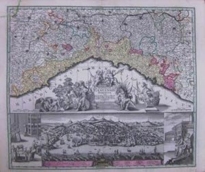
Reipublicae Genuensis Dominium.
Publication Date: 1740
Seller: BOTTEGHINA D'ARTE GALLERIA K�PROS, Rosignano Solvay, LI, Italy
Seller rating 3 out of 5 stars
Art / Print / Poster
No legatura. Condition: Buono. Augusta, 1740 circa. Incisione in rame, colore d'epoca, cm 50 x 58 (alla lastra). Se le carte del Seutter in molto assomigliano a quelle dell'Homann, tanto da non essere talvolta subito distinguibili, ci� che maggiormente le differenzia riguarda il cartiglio, spesso enormemente accresciuto con figure che si rifanno al mito, piuttosto che a qualche potente cui sia dedicata la stampa. Inoltre, non di rado, nella parte inferiore dl foglio, trovano spazio degli scorci di citt�, cosa che costituisce una su caratteristica peculiare rispetto ad altri editori, anche del passato. Esemplare con un'impressione un po' stanca e un leggero foxing al margine bianco, nell'insieme discreto stato.
-
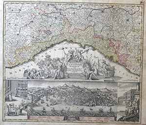
Republicae Genuensis Dominium.
Publication Date: 1740
Seller: BOTTEGHINA D'ARTE GALLERIA K�PROS, Rosignano Solvay, LI, Italy
Seller rating 3 out of 5 stars
Art / Print / Poster
No legatura. Condition: Buono. Augusta, 1740 circa. Incisione in rame, colore d'epoca, cm 50 x 58 (alla lastra), pi� margini. Nella parte superiore carta geografica della Liguria, in quella inferiore una dettagliata veduta a volo d'uccello della citt� di Genova con ai lati due scene in riquadri; al centro un cartiglio con piccolo stemma e ricchissimo di figure allegoriche; in basso una veduta a volo d'uccello con 25 richiami per le cose notabili. Se le carte del Seutter molto assomigliano a quelle dell'Homann, tanto da non essere talvolta subito distinguibili, ci� che maggiormente le differenzia riguarda il cartiglio, spesso enormemente accresciuto, come in questo caso, dall'importanza delle figure legate al mito e all'allegoria. Un'impressione un po' tenue, margini con un leggero e normale ingiallimento, leggermente rifilato sulla destra il margine inferiore in corrispondenza della battuta della lastra, esemplare in bella coloritura e in buono stato di conservazione. .
-
Synopsis Plagae septemtrionalis sive Sueciae Daniae et Norvegiae Regn.
Seller: Herman H. J. Lynge & S�n ILAB-ABF, Copenhagen, Denmark
Seller rating 4 out of 5 stars
(Wien, ca. 1730) (49x58,5 cm.). Kobberstukket, h�ndkoloreet Skandinavienskort med Estland, Letland, Litauen og det vestlige Rusland. Velbevaret indrammet under glas i fin ramme af brun birketr�sfiner. H�ndkolorereingen en smule svag. Kortet er fra Seutter's "Atlas Novus", som blev udgivet 1730-35.