
Order Total (1 Item Items):
Shipping Destination:

Woldermann (10 results)
Skip to main search results
Search filters
Product Type
- All Product Types
- Books (4)
- Magazines & Periodicals (No further results match this refinement)
- Comics (No further results match this refinement)
- Sheet Music (No further results match this refinement)
- Art, Prints & Posters (No further results match this refinement)
- Photographs (No further results match this refinement)
- Maps (6)
- Manuscripts & Paper Collectibles (No further results match this refinement)
Condition Learn more
- New (No further results match this refinement)
- As New, Fine or Near Fine (No further results match this refinement)
- Very Good or Good (6)
- Fair or Poor (No further results match this refinement)
- As Described (4)
Binding
- All Bindings
- Hardcover (2)
- Softcover (No further results match this refinement)
Collectible Attributes
- First Edition (1)
- Signed (No further results match this refinement)
- Dust Jacket (No further results match this refinement)
- Seller-Supplied Images (9)
- Not Print on Demand (10)
Language (1)
Price
- Any Price
- Under US$ 25 (No further results match this refinement)
- US$ 25 to US$ 50 (No further results match this refinement)
- Over US$ 50
Free Shipping
- Free Shipping to U.S.A. (No further results match this refinement)
Seller Location
Seller Rating
-

Zuverl�ssige Nachricht von der Sackschen Familien-Stiftung zu Glogau zum Unterricht der Stiftungs-Berechtigten bei Gelegenheit der zu errichtenden Vergleiche und Familien-Schl�sse und eines neuen Stiftungs-Reglements. [Und Nachtrag].
Published by Glogau G�nter, 1828
Seller: Antiquariat C. Hoffmeister, Wolfenb�ttel, Germany
Seller rating 4 out of 5 stars

[2. A.]. [2. A.]. 8vo. 220, 145 S. Mod. Lwd. mit Deckel- R�ckentitel. Seltene Quelle zu der noch heute existierenden Stiftung. - 2x gestempelt, vereinzelt gering stockfl. {Dazu}: Der Familienrat der Hofrat Simon Heinrich Sack'schen Familienstiftung (Hrsg.). Das Silberne Buch der Familie Sack. 4. Auflage. Band "Genealogie".XLVII, 359 S. Mit 1 farb. Wappentafel. OLwd. 0,800 gr.
-
Plastischer Schul-Atlas �ber alle Theile der Erde in 24 Karten nach Reliefs und Zeichnungen. Ausgabe D.
Published by Leipzig, P. Eckerlein 1879., 1879
Seller: Antiquariat L�cker, Wien, Austria
Association Member: GIAQ ILAB VDA VDAO
Seller rating 5 out of 5 stars

First Edition
Erste Ausgabe. Espenhorst II, 1117ff.; Kretschmer, Lex. 660. Seltener Schulatlas mit Erdteilkarten, verschiedenen Deutschlandkarten, einer Karte der Alpen, sowie Karten mehrerer europ�ischer Staaten, jeweils 1 Karte von Asien, Afrika, Nordamerika, S�damerika, Australien. Die Karten sind in einem - um 1830 entwickelten - als Geomontographie bezeichneten, Pr�geverfahren hergestellt. Die gepr�gten Karten sind an den R�ndern - zum Schutz der Reliefs - bombiert, - Titelbl. mit kl. priv. Eignerstempel, etwas gebr�unt, ansonsten in tadellosem Zustand. Die beiden Karten Westdeutschland und Ostdeutschland sind jeweils 2 x vorhanden. / 24 (+ 2 duplicates) coloured lithographed maps, of which 22 are in three-dimensional relief-technique. 33 x 27,5 cm. Tit., 24 farbige Karten, darunter 22 dreidimensionale Karten in plastischem Pr�gedruck. Dunkelgr�ne OLn.-Kassette mit Schlie�band, Vorderdeckel gold- u. schwarzgepr�gt, Kanten leicht berieben.
-
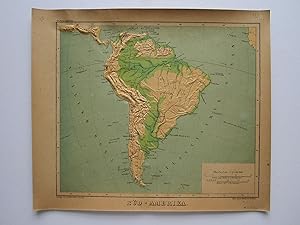
S�d-Amerika
Published by P. Eckerlein, Leipzig, 1879
Seller: Angelika C. J. Friebe Ltd. - MapWoman, Dorking, United Kingdom
Seller rating 5 out of 5 stars
Map
US$ 206.58
US$ 26.74 shipping
Ships from United Kingdom to U.S.A.Quantity: 1 available
Add to basketNo Binding. Condition: Very Good. colour printed and embossed map on thick paper. overall 26 x 30,5 cm, evenly browned, occ. some tiny marginal tears, occ. some faint foxing, 2 bend corners, o/w vg cond. A very rare relief map from 'Plastischer Schulatlas'; the reliefs were created by Lieutenant G. Woldermann and published by P. Eckerlein though some of the maps as well as the binding bear various publishers. The maps are printed in a relief technique Geomontography, a printing method that combined embossing and colour printing, and was mainly applied to the production of maps. The German printer Georg Michael Bauerkeller (1805 1886) and his half-brother Georg Leonhart Bauerkeller developed this technique and applied for a patent in 1839. Geomontography is mainly used for the teaching of the blind.
-
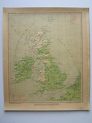
Grossbritannien
Published by P. Eckerlein, Leipzig, 1879
Seller: Angelika C. J. Friebe Ltd. - MapWoman, Dorking, United Kingdom
Seller rating 5 out of 5 stars
Map
US$ 206.58
US$ 26.74 shipping
Ships from United Kingdom to U.S.A.Quantity: 1 available
Add to basketNo Binding. Condition: Very Good. colour printed and embossed map on thick paper. overall 26 x 30,5 cm, evenly browned, occ. some tiny marginal tears, occ. some faint foxing, o/w vg cond. A very rare relief map from Plastischer Schulatlas ; the reliefs were created by Lieutenant G. Woldermann and published by P. Eckerlein though some of the maps as well as the binding bear various publishers. The maps are printed in a relief technique Geomontography, a printing method that combined embossing and colour printing, and was mainly applied to the production of maps. The German printer Georg Michael Bauerkeller (1805 1886) and his half-brother Georg Leonhart Bauerkeller developed this technique and applied for a patent in 1839. Geomontography is mainly used for the teaching of the blind.
-
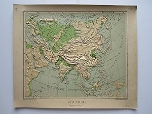
Asien
Published by P. Eckerlein, Leipzig, 1879
Seller: Angelika C. J. Friebe Ltd. - MapWoman, Dorking, United Kingdom
Seller rating 5 out of 5 stars
Map
US$ 275.44
US$ 26.74 shipping
Ships from United Kingdom to U.S.A.Quantity: 1 available
Add to basketNo Binding. Condition: Very Good. colour printed and embossed map on thick paper. overall 26 x 30,5 cm, evenly browned, occ. some tiny marginal tears, occ. some faint foxing, o/w vg cond.- A very rare relief map from Plastischer Schulatlas ; the reliefs were created by Lieutenant G. Woldermann and published by P. Eckerlein though some of the maps as well as the binding bear various publishers.- The maps are printed in a relief technique Geomontography, a printing method that combined embossing and colour printing, and was mainly applied to the production of maps. The German printer Georg Michael Bauerkeller (1805 1886) and his half-brother Georg Leonhart Bauerkeller developed this technique and applied for a patent in 1839. Geomontography is mainly used for the teaching of the blind.
-
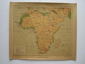
Afrika
Published by P. Eckerlein, Leipzig, 1879
Seller: Angelika C. J. Friebe Ltd. - MapWoman, Dorking, United Kingdom
Seller rating 5 out of 5 stars
Map
US$ 275.44
US$ 26.74 shipping
Ships from United Kingdom to U.S.A.Quantity: 1 available
Add to basketNo Binding. Condition: Very Good. colour printed and embossed map on thick paper. overall 26 x 30,5 cm, evenly browned, occ. some tiny marginal tears, occ. some faint foxing, 2 bend corners, o/w vg cond.- A very rare relief map from 'Plastischer Schulatlas'; the reliefs were created by Lieutenant G. Woldermann and published by P. Eckerlein though some of the maps as well as the binding bear various publishers.- The maps are printed in a relief technique Geomontography, a printing method that combined embossing and colour printing, and was mainly applied to the production of maps. The German printer Georg Michael Bauerkeller (1805 1886) and his half-brother Georg Leonhart Bauerkeller developed this technique and applied for a patent in 1839. Geomontography is mainly used for the teaching of the blind.
-
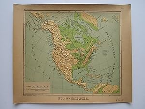
Nord- Amerika
Published by P. Eckerlein, Leipzig, 1879
Seller: Angelika C. J. Friebe Ltd. - MapWoman, Dorking, United Kingdom
Seller rating 5 out of 5 stars
Map
US$ 275.44
US$ 26.74 shipping
Ships from United Kingdom to U.S.A.Quantity: 1 available
Add to basketNo Binding. Condition: Very Good. colour printed and embossed map on thick paper. overall 26 x 30,5 cm, evenly browned, occ. some tiny marginal tears, occ. some faint foxing, o/w vg cond. A very rare relief map from 'Plastischer Schulatlas'; the reliefs were created by Lieutenant G. Woldermann and published by P. Eckerlein though some of the maps as well as the binding bear various publishers. The maps are printed in a relief technique Geomontography, a printing method that combined embossing and colour printing, and was mainly applied to the production of maps. The German printer Georg Michael Bauerkeller (1805 1886) and his half-brother Georg Leonhart Bauerkeller developed this technique and applied for a patent in 1839. Geomontography is mainly used for the teaching of the blind.
-
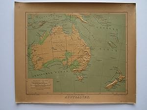
Australien
Published by P. Eckerlein, Leipzig, 1879
Seller: Angelika C. J. Friebe Ltd. - MapWoman, Dorking, United Kingdom
Seller rating 5 out of 5 stars
Map
US$ 275.44
US$ 26.74 shipping
Ships from United Kingdom to U.S.A.Quantity: 1 available
Add to basketNo Binding. Condition: Very Good. colour printed and embossed map on thick paper. overall 26 x 30,5 cm, evenly browned, occ. some tiny marginal tears, occ. some faint foxing, o/w vg cond.- A very rare relief map from Plastischer Schulatlas ; the reliefs were created by Lieutenant G. Woldermann and published by P. Eckerlein though some of the maps as well as the binding bear various publishers.- The maps are printed in a relief technique Geomontography, a printing method that combined embossing and colour printing, and was mainly applied to the production of maps. The German printer Georg Michael Bauerkeller (1805 1886) and his half-brother Georg Leonhart Bauerkeller developed this technique and applied for a patent in 1839. Geomontography is mainly used for the teaching of the blind.
-

Europa (Europe)
Publication Date: 1879
Seller: Art Source International Inc., Boulder, CO, U.S.A.
Seller rating 5 out of 5 stars
Not found in any of the reference texts, these maps by Woldermann may indeed be the first raised relief maps published. While we have seen early US made raised relief maps that date to the 1880s, never have we seen these rare German maps which predate US developments by almost a decade. The maps themselves are composed of a sturdy pressed paper, which forms with intricate detail and has endured amazingly well. These are fascinating tactile creations that allow us to feel the river valleys, plateaus, hills and mountains of the world, as they were known in the 1870's. The maps themselves are well detailed for place names, borders and even land quality. The lithographic color amplifies these maps visually, and has remained strong. Condition is good with toning around the edges. This map measures 11 inches by 8.75 inches.
-

Skandinavien (Norway and Sweden)
Publication Date: 1879
Seller: Art Source International Inc., Boulder, CO, U.S.A.
Seller rating 5 out of 5 stars
Not found in any of the reference texts, these maps by Woldermann may indeed be the first raised relief maps published. While we have seen early US made raised relief maps that date to the 1880s, never have we seen these rare German maps which predate US developments by almost a decade. The maps themselves are composed of a sturdy pressed paper, which forms with intricate detail and has endured amazingly well. These are fascinating tactile creations that allow us to feel the river valleys, plateaus, hills and mountains of the world, as they were known in the 1870's. The maps themselves are well detailed for place names, borders and even land quality. The lithographic color amplifies these maps visually, and has remained strong. Condition is good with toning around the edges. This map measures 8.5 inches by 11 inches.

