Order Total (1 Item Items):
Shipping Destination:

Waldeck Comitatus (54 results)
Skip to main search results
Search filters
Product Type
- All Product Types
- Books (11)
- Magazines & Periodicals (No further results match this refinement)
- Comics (No further results match this refinement)
- Sheet Music (No further results match this refinement)
- Art, Prints & Posters (9)
- Photographs (No further results match this refinement)
- Maps (34)
- Manuscripts & Paper Collectibles (No further results match this refinement)
Condition Learn more
- New (No further results match this refinement)
- As New, Fine or Near Fine (2)
- Very Good or Good (7)
- Fair or Poor (No further results match this refinement)
- As Described (45)
Binding
- All Bindings
- Hardcover (No further results match this refinement)
- Softcover (2)
Collectible Attributes
- First Edition (No further results match this refinement)
- Signed (No further results match this refinement)
- Dust Jacket (No further results match this refinement)
- Seller-Supplied Images (46)
- Not Print on Demand (54)
Language (4)
Free Shipping
- Free Shipping to U.S.A. (No further results match this refinement)
Seller Location
Seller Rating
-

Condition: Ottimo. Rara e grande ristampa dei primi '900 Stampata su carta speciale Carta geografica o Mappa Waldeck Comitatus Anno 1650 Dimensioni: Cm 55,00 x 40,00 Codice prodotto: Litografie - 1301 Qualora vogliate delle scansioni migliori contattateci, soddisferemo ogni vostra richiesta. Paypal Carta di credito Bonifico bancario Accuratamente adagiate su un cartoncino e protette da pellicola trasparente rigida, il tutto viene inserito dentro plico di adeguate dimensioni per proteggerne l'integrit�. Litografie-1301.
-
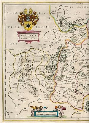
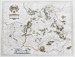
Waldeck Comitatus.
Published by AmsterdamJansson., 1634
Seller: Robert Frew Ltd. ABA ILAB, London, United Kingdom
Association Member: ABA ILAB PBFA
Seller rating 5 out of 5 stars

Map
US$ 55.09
US$ 13.37 shipping
Ships from United Kingdom to U.S.A.Quantity: 1 available
Add to basket14.2 x 19.3 cm. Uncoloured. Single page map of the region surrounding Waldeck, northern Hessen. Latin text on verso. Light dampstain across upper and right edges of sheet.
-

"Waldeck Comitatus" - Waldeck Hessen Korbach Bad Arolsen Volksmarsen Wildungen Medebach
Language: French
Published by Amsterdam, Hondius c. 1606., 1606
Seller: Antiquariat Steffen V�lkel GmbH, Seubersdorf, Germany
Seller rating 5 out of 5 stars
Map
Rare map with original color from a French edition of Mercator's Atlas Major. -- With rare original color, no modern coloring! With French text on verso. -- in very good condition. || Seltene Karte mit originalem Altkolorit aus einer franz�sischen Ausgabe von Mercator's Atlas Major. -- Ma�: c. 36 x 46 cm. -- Kein modernes Kolorit! Mit franz�sischem Text auf der R�ckseite. -- gut erhalten. || Dies ist ein Original! - Kein Nachdruck! - Keine Kopie! -- This is an original! - No copy! - No reprint! // Wir, das Antiquariat Steffen V�lkel, kaufen und verkaufen alte B�cher, Handschriften, Zeichnungen, Autographen, Grafiken und Fotografien. Wir sind stets am Ankauf von kompletten Bibliotheken, Sammlungen und Nachl�ssen interessiert. Sprache: Franz�sisch Gewicht in Gramm: 550.
-

Waldeccensis Comitatus Descriptio Accuratissima. - Dekorative fl�chenkolorierte Karte. - Dargestellt ist das F�rstentum Waldeck nach der Zeichnung von Justus Moers aus dem Jahre 1575.
Language: German
Published by Selbstverlag, Antwerpen, 1579
Seller: Antiquariat und Verlag Gerhard Henrich, Langenbieber, Germany
Seller rating 5 out of 5 stars
Map
Softcover. Condition: Gut. Dekorative kolorierte Karte im Format 31,5 x 22 cm auf B�tten im Format 43,5 x 26 cm, links etwas knapp (2 mm) beschnitten,
-

"Landgraviatus Hassiae Inferioris nova Tabula, in qua praecipue Ditiones Hasso-Casselense et Comitatus Waldeck cum insertis et vicinis alioru Statuum Praefecturis exhibentur" - Hessen Kassel H�xter Paderborn Schmalkalden Bad Hersfeld Hann. M�nden G�ttingen Baunatal Fritzlar Karte map
Language: Latin
Published by N�rnberg ca. 1720., 1720
Seller: Antiquariat Steffen V�lkel GmbH, Seubersdorf, Germany
Seller rating 5 out of 5 stars
Map
Original altkolorierte Kupferstich-Karte von ca. 1720. -- Blatt-Ma�e: ca. 53,5 x 61 cm. -- in den R�ndern teils etwas fleckig, im unteren Mittelbug teils hinterlegt, sonst gut erhalten. || Original old colored engraved map from ca. 1720. -- partly stained on the margins, partly deposited on the lower part of the centerfold, otherwise in good condition. // Wir, das Antiquariat Steffen V�lkel, kaufen und verkaufen alte B�cher, Handschriften, Zeichnungen, Autographen, Grafiken und Fotografien. Wir sind stets am Ankauf von kompletten Bibliotheken, Sammlungen und Nachl�ssen interessiert. la Gewicht in Gramm: 30.
-
Kolorierte Kupferstich-Landkarte nach Mercator / Hondius. Waldeck comitatus per Gerardum Mercatorem cum privilegio.
Published by Amsterdam, Hondius, um 1610., 1610
Art / Print / Poster
circa 43 x 55 cm. 1 Doppelblatt verso franz�sischer Text (Le comte de Waldeck?) Oben links Krtusche, unten Meilenzeiger, mit Korbach, Bad Arolsen, Volksmarsen, Wildungen etc., oben Teil der Gegend um Paderborn. - Mittelfalte hinterlegt, angesetzt (ohne Verlust), kaum angstaubt, wenig fleckig in den R�ndern, leicht knittrig, gut erhalten meist sauber und sch�ner Gesamteindruck.
-
Landgraviatus Hassiae Inferioris nova Tabula in qua praecipue ditionis Hasso-Casselense et Comitatus Waldeck .
Published by N�rnberg [um 1730],
Condition: -. Altkolorierter Kupferstich. 48,5 x 57,5 cm. 2 dekorativen Kartuschen. Zeigt auch die Grafschaft Waldeck, sowie im Osten das Eichsfeld. R�nder leicht gebr�unt. Guter Zustand.
-

'WALDECCENSIS COMITATUS DESCRIPTIO ACCURATISSIMA'. Map of Waldeck in northern Hessen, reaching from Brilon to Warburg and from Frankenberg to Geismar. Korbach in the centre. Designed by Justus Moers for
Published by Abraham Ortelius and dated 1575, 1575
Map
US$ 103.29
US$ 40.11 shipping
Ships from United Kingdom to U.S.A.Quantity: 1 available
Add to basket31x22cm. Laid down on board. Original outline colour. Excellent condition.
-
WALDECK Comitatus.
Published by Atlas Minor. Jan Jansson the Elder. 1628, Latin edition., 1628
Seller: Peter Harrington. ABA/ ILAB., London, United Kingdom
Association Member: ABA ILAB PBFA
Seller rating 5 out of 5 stars
US$ 130.83
US$ 29.42 shipping
Ships from United Kingdom to U.S.A.Quantity: 1 available
Add to basketIn 1604 Hondius bought the plates of Gerard Mercator's atlas, added about 40 maps to Mercator's original number, and from 1606 published enlarged editions in many languages still under Mercator's name, but with his own name as publisher. These atlases have become known as the Mercator/Hondius series. The following year the maps were re-engraved in miniature form and issued as a pocket Atlas Minor. Bannister/Moreland - Antique Maps pp. 97 & 102. Copper engraving. In fine condition. Later colour. Size: 19 x 12 cm. (7� x 4� inches).
-
Kein Einband. Condition: Gut. 38,2 x 50 cm gefaltete Landkarte, mit Mittelfalz, Papier altersbedingt etwas gebr�unt, sonst GUTES EXEMPLAR---Mit lateinischem R�ckseitentext. Blatt: 44 x 55,2 cm F�r Ihre Zufriedenheit versenden wir mit DHL und ausschlie�lich mit Trackingcode f�r eine sichere Sendungsverfolgung! Weitere Angebote unter antiquariat-kastanienhof , 1 Seiten. nein.
-

Waldeck Comitatus. Waldeck Comitatus. - Gerard Mercator ? Hand-Colored Original Copperplate Engraving ? Amsterdam 1630
Published by I.E. Cloppenburgh, Amsterdam, 1630
Seller: Antiquariat Reinhold Berg eK Inh. R.Berg, Regensburg, Germany
Seller rating 5 out of 5 stars
Map
Other. Hand-Colored Original Copperplate Engraving by Gerard Mercator, depicting Waldeck Comitatus. Published Amsterdam, I.E. Cloppenburgh, 1630. Sheet: 180 by 248mm (7 by 9 inches). A fine and original hand-colored example of Mercator's celebrated cartographic work, documenting this region of Germany with the precision and decorative artistry characteristic of the 16300s. Gerardus Mercator (1512-1594) was the greatest cartographer of the 16th century. Born in Flanders, he invented the Mercator projection in 1569 -- a revolutionary cylindrical map projection still used in nautical charts today. He was the first to use the word 'atlas' for a collection of maps, honouring the Titan who held up the world. His 1585 atlas of France, Germany, and the Low Countries was the first in a series that would be completed and republished by his heirs and successors, most notably Hondius and Janssonius. Mercator maps are prized by collectors for their historical importance and elegant Renaissance engraving, and are held in leading institutions including the Biblioth�que nationale de France and the British Library.This original copperplate engraving, with original hand coloring depicts the region of Waldeck Comitatus., published in Amsterdam, I.E. Cloppenburgh, 1630. The map records the political and geographic boundaries of the region as understood in 1630, offering a fascinating window into the history of German territorial organization. Sheet measures 180 by 248mm (7 by 9 inches). In good condition overall, with minor signs of age appropriate for a 17th-century engraving. Ready to frame. Koeman, ME 198 In excellent condition. 180 by 248mm (7 by 9 inches). 180 by 248mm (7 by 9 inches).
-

Waldeck Comitatus Per Gerardum Mercator.-
Published by Amsterdam: Henri Du Sauzet [nach ], 1737
Seller: Antiquariat Tautenhahn, L�beck, Germany
Association Member: GIAQ ILAB VDA
Seller rating 5 out of 5 stars
Art / Print / Poster
Kupferstich 16 x 22,5 cm, Blattgr��e 23 x 34,5 cm. Die Landkarte zeigt das Gebiet Waldeck in Hessen. Am oberen Bildrand Paderbornensis Episcopatus pars, links Coloniensis Dioecesis Pars. Oben links die Titelkartusche mit einem Meilenanzeiger und dem Namen Mercator. Am unteren Bildrand Petrus Kaerius Caelavit. - Aus: Atlas Portatif Compos� de CCLXXXV Cartes. - Sauberes Blatt in kraftvollem Druck.
-
Landgraviatus Hassiae inferioris. et comitatus Waldeck. orig. kol. Kupferstichkarte mit 2 fig�rlichen Kartuschen oben links und oben rechts.
Published by N�rnberg, ca., ., 1720
Gebiet: Herborn - Paderborn, Smalkalden - Elmbecke 47 x 56 cm kr�ftiger Abdruck, einmal gefaltet.
-
Waldeck Comitatus
Published by Joannem Janssonium c. 1640, Amsterdam, 1640
Seller: William Chrisant & Sons, ABAA, ILAB. IOBA, ABA, Ephemera Society, Fort Lauderdale, FL, U.S.A.
Association Member: ABAA ESA ILAB
Seller rating 5 out of 5 stars
Condition: Very Good. Amsterdam: Joannem Janssonium. Very Good. c. 1640. Seventeenth century map with original, hand-colored outlines of Waldeck, Germany. Decorative cartouche. Gilt highlights to cities & cartouches. Some foxing, most apparent to margins. Otherwise, a handsome copy. Latin text to verso with historiated initial. Please see image. Plate size approximately 20 x 14 1/2 in. Overall size approx. 22 1/2 x 17 1/4 in (565 x 435 mm).; All shipments through USPS insured Priority Mail. .
-

Landgraviaius Hassiae Inferioruis nova Tabula , in qua praecipue Ditiones Hasso Casselense et Comitatus Waldeck . -
Published by N�rnberg: Homann um, 1720
Seller: Antiquariat Tautenhahn, L�beck, Germany
Association Member: GIAQ ILAB VDA
Seller rating 5 out of 5 stars
Art / Print / Poster
Altkolorierter Kupferstich 48,5 x 57,5 cm, Blattgr��e 54 x 59,5 cm. Die Karte in altem Fl�chenkolorit zeigt mittig Kassel, im Norden Oldendorff und im S�den Fulda. In der linken oberen Ecke eine gro�e Kartusche mit dem Titel, einem Wappen und lebhafter fig�rlicher Staffage. In der rechten oberen Ecke ein Meilenanzeiger mit mythologischer Szene.- Johann Baptiste Homann 1663 - 1724, Kupferstecher und Verleger in N�rnberg. - Das Papier im Bereich des ehemaligen Passepartoutausschnittes leicht gebr�unt. Im Mittelfalz zwei Stellen beschabt. Leuchtendes Altkolorit.
-

Waldeck Comitatus. -
Published by Amsterdam: Blaeu [um ], 1635
Seller: Antiquariat Tautenhahn, L�beck, Germany
Association Member: GIAQ ILAB VDA
Seller rating 5 out of 5 stars
Art / Print / Poster
Grenzkolorierter Kupferstich 38 x 50 cm, Blattgr��e 51 x 60,5 cm. Die Kupferstichkarte zeigt mittig das Gebiet von Waldeck, in der linken oberen Ecke die Titelkartusche, dar�ber ein dekoratives Wappen. Unten links in einer kleinen, von Putti gehaltenen Kartusche ein Meilenanzeiger. Im Bild unten rechts: Amsterdami Apud Guiljemum Blaeu. Die Grenzen, gr��ere Waldgebiete und die gr��eren St�dte koloriert. - Blaeu, Willem (d.i. Guiljelmum) 1571-1638, Kartograph und Verleger, Herausgeber von Theatre du monde. Seine S�hne setzten seine Arbeit fort. - Im Bereich des ehemaligen Passepartoutausschnittes leicht gebr�unt. Sch�nes, breitrandiges Exemplar.
-

Waldeck Comitatus.
Published by Artist: Mercator Gerhard ( - 1594 ) Duisburg ca : 1595, 1512
Seller: Antique Sommer& Sapunaru KG, M�nchen, Germany
Seller rating 4 out of 5 stars

Technic: Copper print, colorit: original colored, condition: Restoration at centerfold, size (in cm): 36 x 46 cm, Map shows the surroundings of Waldeck in Hesse with a mileage scale and title cartouche.
-

Waldeck Comitatus.
Published by Artist: Blaeu Willem Janszoon ( - 1638 ) Amsterdam ca : 1640, 1571
Seller: Antique Sommer& Sapunaru KG, M�nchen, Germany
Seller rating 4 out of 5 stars
Technic: Copper print, colorit: colored, condition: Very good, size (in cm): 38 x 50 cm, Map shows the surroundings of Waldeck in Hesse with a mileage indicator cartouche and title cartouche with the coat of arms of Waldeck.
-
"Waldeck Comitatus" - F�rstentum Waldeck Bad Wildungen Korbach Hessen Arolsen Marsberg Brilon
Language: Latin
Published by Amsterdam ca. 1640., 1640
Seller: Antiquariat Steffen V�lkel GmbH, Seubersdorf, Germany
Seller rating 5 out of 5 stars
Map
Gro�e altkolorierte Kupferstich-Karte von ca. 1640. -- Mit lateinischem Text auf der R�ckseite. -- Blatt-Ma�e: ca. 49,5 x 59 cm. -- gut erhalten. || Large old colored map from c. 1640. With Latin text on verso. -- in good condition. || Dies ist ein Original! - Kein Nachdruck! - Keine Kopie! -- This is an original! - No copy! - No reprint! // Wir, das Antiquariat Steffen V�lkel, kaufen und verkaufen alte B�cher, Handschriften, Zeichnungen, Autographen, Grafiken und Fotografien. Wir sind stets am Ankauf von kompletten Bibliotheken, Sammlungen und Nachl�ssen interessiert. la.
-
Landgraviatus Hassiae Inferioris nova Tabula in qua praecipue ditionis Hasso-Casselense et Comitatus Waldeck. Altkolorierter Kupferstich mit 2 unkolor. fig�rlichen Kartuschen.
Language: German
Published by N�rnberg, [ca. ], 1720
Seller: Antiquariat Reinhold Pabel, Hamburg, Germany
Association Member: BOEV
Seller rating 5 out of 5 stars
Map
N�rnberg, [ca. 1720]. Darstellung: 48,5 x 57,5 cm. Unter altem Schr�gschnittpassepartout. Landkarte von Nordhessen u. Waldeck in altem Grenz- u. Fl�chenkolorit. Links oben Titelkartusche mit Wappen u. Putti; die Kartusche rechts oben: eine Jagdszene mit Hirsch in bewaldetem Mittelgebirge. Mit dem bekannten Mittelfalz. - Papierverlust an linker u. rechter unterer Ecke durch Feuchtigkeitseinwirkung, kurzer Einriss im unteren Falz hinterlegt; unter der Presse entstandene Quetschfalte im rechten Bildteil. Dank des kr�ftigen, scharfgratigen Abdrucks noch immer beeindruckendes Kartenbild.
-

"Hassia Lantgraviatus Tam Superior Casselanensis quam Inferior Darmstadina quibus includunter et circumjacent Ducatus Anderlahn Comitatus Rheinfelt Homburg Waldeck Solms Sigen Dillenburg Witgenstein Hatzfelt et Abbatia Hirschfelt" - Hessen Marburg Giesen Kassel Wetzlar Waldeck Korbach
Language: Latin
Published by Amsterdam ca. 1700., 1700
Seller: Antiquariat Steffen V�lkel GmbH, Seubersdorf, Germany
Seller rating 5 out of 5 stars
Map
Altkolorierte Kupferstich-Karte von ca. 1700. -- Blatt-Ma�e: ca. 53 x 61 cm. -- gut erhalten. || Old colored engraved map from ca. 1700. -- in good condition. // Wir, das Antiquariat Steffen V�lkel, kaufen und verkaufen alte B�cher, Handschriften, Zeichnungen, Autographen, Grafiken und Fotografien. Wir sind stets am Ankauf von kompletten Bibliotheken, Sammlungen und Nachl�ssen interessiert. la Gewicht in Gramm: 550.
-

Waldeck comitatus.
Seller: Antiquariat Peter Fritzen, Speicher, Germany
Seller rating 5 out of 5 stars
Map
Kupferstich-Karte bei Mercator-Janssonius, 1648, grenz- und fl�chenkoloriert. Ca. 14,3 x 19,4 cm. Aus dem Atlas Minor von 1648, mit deutschem R�ckentext. Links oben Titelkartusche mit Stechersignatur "Petrus Kaerius caelavit" und Meilenzeiger.
-

S.R.I. (S.acri R.omani I.mperii) Circulus Rhenanus superior in quo sunt Landgraviatus Hasso-Casselensis, Darmstadtiensis et Rhenofeldensis Abatin Fuldensis Principatus Waldeck et Hirschfeld. Comitatus Nassau-Weilburg, Usingen, Wisbaden, et Idstein Solmensis Hanoviensis Isenburgensis superior Witgenstein Hatzfeld Westerburg et Hachenburg Urbes imperiales: Franckfurt, Fridberg, Wetzlar et Gelenhausen.
Language: German
Published by N�rnberg, farbkollorierter Kupferstich, 1720
Seller: Antiquariat im Schloss, Schwaigern, D, Germany
Seller rating 5 out of 5 stars
Map
Bildgr��e 48,7 x 56,9 cm. Kr�ftiger Druck. Oben knapp beschnitten, jedoch ohne Bild verlu�t. Grosse Wappenkartusche (oben links) mit 21 Wappen. Unten rechts eine Kartusche mit Legende, Meilenzeiger, 2 Puteni und (wohl) Hopfenranken. (Foto von dem eingerahmten Blatt, � 380,-) Sprache: Deutsch Gewicht in Gramm: 900.
-
Waldeck Comitatus. Altkolor. Kupferstich von W. Blaeu. Amsterdam, 1635. 38,2 x 49,9 cm.
Language: German
Publication Date: 1635
Seller: Antiquariat Daniel Schramm e.K., Kiel, Germany
Seller rating 4 out of 5 stars
Condition: 0. Zeigt das F�rstentum Waldeck.- Oben links Wappen �ber kleiner Titelkartusche, Meilenzeiger mit 3 Putten unten links.- Auf Karton aufgezogen.- Hesse - Waldeck Comitatus. Old col. Engraving by W. Blaeu. Amsterdam, 1635. 38.2 x 49.9 cm. Showing the Principality of Waldeck - Coat of arms above small title cartouche upper left, mileage scale with 3 putti lower left - Mounted on cardboard. Sprache: Deutsch Gewicht in Gramm: 500.
-

s.a. MAPA ANTIGUO: "WALDECK Comitatus. Per Gerardum Mercator". Cloppenburg / Janssonius van Waesberghe. Amsterdam 1673 1 hoja. Hoja apaisada de 27x20,5 cm. (Caja: 24,5 x 18 cm) -2KG Con indicaci�n de r�os, bosques, monta�as y poblaciones, etc. Posible grabador: P. Kaerius (van den Keere). COLOREADO. Esta edici�n de 1673 se realiz� probablemente con las placas de Croppenburg, editor del "Atlas Minor" de G. Mercator entre 1630 y 1636. S (Ref.38585) cartografia antigua europa alemania germania.
-

WALDECK. - Karte. Waldeck Comitatus. Altkol. Kupferstich von Blaeu, um 1640, Karte des F�rstentums Waldeck. Links oben altkolorierte Titelkartusche.
Language: German
Published by ohne Verlagsangabe um 1740., 1740
Art / Print / Poster
Kartenma�e 56 x 44,5 cm. Condition: Gut. Auflage ohne Angabe. 1 Blatt Kupferstich guter Zustand, siehe Foto.Lieferung erfolgt in Kartenrollen. Sprache: Deutsch Gewicht in Gramm: 1100.
-

S.R.I. (S.acri R.omani I.mperii) Circulus Rhenanus superior in quo sunt Landgraviatus Hasso-Casselensis, Darmstadtiensis et Rhenofeldensis Abatin Fuldensis Principatus Waldeck et Hirschfeld. Comitatus Nassau-Weilburg, Usingen, Wisbaden, et Idstein Solmensis Hanoviensis Isenburgensis superior Witgenstein Hatzfeld Westerburg et Hachenburg Urbes imperiales: Franckfurt, Fridberg, Wetzlar et Gelenhausen.
Language: German
Published by N�rnberg, farbkollorierter Kupferstich, 1720
Seller: Antiquariat im Schloss, Schwaigern, D, Germany
Seller rating 5 out of 5 stars
Map
Kr�ftiger Druck. Grosse, farbige Wappenkartusche (oben links) mit 21 Wappen. Unten rechts eine Kartusche mit Legende, Meilenzeiger, 2 Puteni und (wohl) Hopfenranken. (Foto von dem eingerahmten Blatt) Sprache: Deutsch Gewicht in Gramm: 900 In einem sch�nem Rahmen, Eingerahmt: 74x67cm; Bildgr��e 48,7 x 56,9 cm.
-
"Waldeck Comitatus".
Seller: Antiquariat Peter Fritzen, Speicher, Germany
Seller rating 5 out of 5 stars
Map
Kupferstich-Karte, Janssonius, ca. 1647. 38 x 50 cm. Zwei centgro�e Rost(?)-flecken. Mit franz�sischem R�ckentext. Links unten Meilenzeiger mit drei Putti. Rechts unten Druckvermerk "Amstelodami Apud Ioannem Ian�onium". Links oben Titelkartusche, dar�ber Wappen.
-
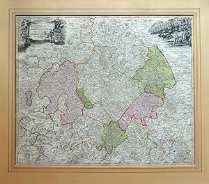
Landgraviatus Hassiae Inferioris nova Tabula, in qua praecipue Ditiones Hasso-Casselense et Comitatus Waldeck cum insertis et vicinis alioru Statuum Praefecturis exhibentur a Ioh. Bapt. Homanno Noriberge.
Published by N�rnberg Homann, 1710
Seller: Neusser Buch & Kunst Antiquariat, Neuss, NRW, Germany
Seller rating 5 out of 5 stars
Art / Print / Poster
Kupferstich, altkoloriert, Grenz- und Fl�chenkolorit, Darstellung: 58 x 48,5 Blatt: 59,5 x 52,5 cm Mittelfalz, Abruck etwas schwach, Mittelfalz unterlegt(alt) und einige Randeinrisse geklebt (unterlegt, alt), im Ganzen gut erhalten. Auf Wunsch Digitalaufnahme in jpg-Format erh�ltlich- photo in jpg-format available. Je nach Versandart k�nnen die Portokosten bis zu 2 weniger als angegeben betragen. Links oben figurale Kartusche mit Wappen und Putten, recht oben Walddarstellung mit Hirsch (schwacher Druck) und Meilenanzeiger. Westen: Dillenburg, Fredeburg (Westfalen), Norden: (Herzogtum Braunschweig), H�xter, Einbeck, Osten: Gotha, Bad Langensalza. Sprache: Deutschu.
-

Waldeck Comitatus.
Published by Joan Blaeu, 1638
Seller: Antiquariaat Dat Narrenschip, Middelburg, Netherlands
Seller rating 5 out of 5 stars
Map
No Binding. Condition: Fine. Antique map of the county of Waldeck. Back side French text. Copper engraving with nice old colour, published in 1638 in Amsterdam by Joan Blaeu in "Le Theatre du Monde." Dimensions (image): 38 x 50 cm.