
Order Total (1 Item Items):
Shipping Destination:

D 1703 (26 results)
Author:
d 1703
Refine with Advanced Search
Skip to main search results
Search filters
Product Type
- All Product Types
- Books (22)
- Magazines & Periodicals (No further results match this refinement)
- Comics (No further results match this refinement)
- Sheet Music (No further results match this refinement)
- Art, Prints & Posters (1)
- Photographs (No further results match this refinement)
- Maps (3)
- Manuscripts & Paper Collectibles (No further results match this refinement)
Condition Learn more
- New (No further results match this refinement)
- As New, Fine or Near Fine (2)
- Very Good or Good (5)
- Fair or Poor (No further results match this refinement)
- As Described (19)
Binding
Collectible Attributes
- First Edition (5)
- Signed (1)
- Dust Jacket (No further results match this refinement)
- Seller-Supplied Images (21)
- Not Print on Demand (26)
Language (4)
Price
- Any Price
- Under US$ 25 (No further results match this refinement)
- US$ 25 to US$ 50
- Over US$ 50
Free Shipping
Seller Location
Seller Rating
-
![Seller image for Phoenix series [52 Volumes]: Love sonnets / William Shakespeare ; Goblin market / Christina Rossetti ; Fern Hill / Dylan Thomas ; The eve of St. Agnes / by John Keats ; Love poems / John Donne ; The rime of the ancient mariner / Samuel Taylor Coleridge ; Don Juan / Lord Byron ; High waving heather / the Bront�s ; A visitation of the Plague / Daniel Defoe ; Counsels on the spiritual life / Thomas A Kempis ; Sailing to Byzantium / W.B. Yeats ; Intimations of immortality / William Wordsworth ; The ballad of Reading Gaol / Oscar Wilde ; Palgrave's golden treasury of love poems ; The Marquise of O-- ; Natural selection / Charles Darwin ; Voyage around the Horn / Joshua Slocum ; Churchill : embattled hero / Andrew Roberts ; The great fire of London / Samuel Pepys ; The Satyricon : dinner with Trimalchio / Petronius ; The necklace, and other stories / Guy de Maupassant ; translated by Marjorie Laurie ; Fanny Hill / John Cleland ; From bed to bed / Catullus ; Science, mind & cosmos / William H for sale by MW Books Ltd.](https://pictures.abebooks.com/inventory/md/md31301218020.jpg)
Phoenix series [52 Volumes]: Love sonnets / William Shakespeare ; Goblin market / Christina Rossetti ; Fern Hill / Dylan Thomas ; The eve of St. Agnes / by John Keats ; Love poems / John Donne ; The rime of the ancient mariner / Samuel Taylor Coleridge ; Don Juan / Lord Byron ; High waving heather / the Bront�s ; A visitation of the Plague / Daniel Defoe ; Counsels on the spiritual life / Thomas A Kempis ; Sailing to Byzantium / W.B. Yeats ; Intimations of immortality / William Wordsworth ; The ballad of Reading Gaol / Oscar Wilde ; Palgrave's golden treasury of love poems ; The Marquise of O-- ; Natural selection / Charles Darwin ; Voyage around the Horn / Joshua Slocum ; Churchill : embattled hero / Andrew Roberts ; The great fire of London / Samuel Pepys ; The Satyricon : dinner with Trimalchio / Petronius ; The necklace, and other stories / Guy de Maupassant ; translated by Marjorie Laurie ; Fanny Hill / John Cleland ; From bed to bed / Catullus ; Science, mind & cosmos / William H
Language: English
Published by London: Phoenix Edition, 1996
ISBN 10: 1857995570 ISBN 13: 9781857995572
Reprint. Fine paperback copy. Particularly and surprisingly well-preserved; tight, bright, clean and especially sharp-cornered. Physical description; 52 volumes ; 15 cm. Subjects; Love poetry, English. Sonnets, Englis h. English poetry. English literature. Poetry, Modern 19th century. Plague in literature. 1 Kg.
-

Tryon , Thomas - an Original Antique Portrait
Language: English
Seller: K Books Ltd ABA ILAB, York, YORKS, United Kingdom
Association Member: ABA ILAB PBFA
Seller rating 5 out of 5 stars

US$ 34.11
US$ 25.83 shipping
Ships from United Kingdom to U.S.A.Quantity: 1 available
Add to basketNo Binding. Condition: Very Good. A splendid antique portrait, circa 1819. Mounted/matted and ready to frame. Attractive and decorative.
-
The Lives of the Poets of Great-Britain and Ireland, to the Time of Dean Swift. by Mr. Cibber, and other Hands. In Five Volumes.
Language: English
Published by Georg Olms Verlagsbuchhandlung, Hildesheim, 1968
US$ 170.55
US$ 34.43 shipping
Ships from United Kingdom to U.S.A.Quantity: 1 available
Add to basketHardcover. Condition: Very Good. Facsimile. Five volumes. Hildesheim: Georg Olms Verlagsbuchhandlung, 1968. �A facsimile of the 1753 edition reproduced from a copy in the Library of the University of Gottingen (Shelfmark : H lit. biogr. I 8464). Original red cloth, black lettering-piece, gilt lettering and decoration. No dustwrappers, as issued. Small light mark to edge of spine of volume one. A very good set. (**PLEASE READ CAREFULLY** - Heavy/overweight item weighing 2.2 kg packed, therefore additional postage will be required - please ask for a prior shipping quote).
-
Historia del famoso predicador Fray Gerundio de Campazas, alias Zotes, escrita por el Ldo. D./. quien la dedica al p�blico. Tomos I y II
Language: Spanish
Published by En la imprenta de D. Gabriel Ramirez/ En Campazas (�Bayona?), a costa de los Herederos de Fr. Gerundio - 1758-1870, Madrid, 1758
First Edition
Encuadernaci�n de tapa dura. Condition: Muy bueno. 21 cm. Dos vol�menes encuadernados en plena piel de �poca, con ruedas doradas en planos y otros hierros dorados en lomos. Cortes tintados. La primera edici�n del Tomo I de esta obra (destinada a combatir, con la s�tira y el rid�culo, la degeneraci�n en que hab�a ca�do la predicaci�n) hab�a sido secuestrada por la Inquisici�n. Nuestro ejemplar corresponde a una rar�sima edici�n del mismo contenido, fecha y pie de imprenta que la primera, publicada, al parecer, con car�cter extraoficial y que el estudioso de estas ediciones, Jos� Jurado, califica como edici�n 1758(2). El Tomo Segundo no se public� hasta 1768, tambi�n de modo clandestino y cuando el P. Isla resid�a en Italia, como jesuita expulso. Nuestro ejemplar corresponde a la considerada edici�n oficial, de 1770, y en cuyo pie figura como publicado en 'Campazas' (�Bayona?), 'a costa de los Herederos de Fr. Gerundio'. Los dos vol�menes en excelente conservaci�n, con encuadernaci�n id�ntica, de �poca, lo que indica que sus propietarios iniciales la consideraron como edici�n completa. 395 pp. 1 pp. s/n, 1 h. bl. / 313, 1 pp. 2 h. bl. En espa�ol. Book in spanish.
-
La philosophie du bon sens, ou R�flexions philosophique sur l'incertitude des connaissances humaines, a l'usage des cavaliers et du beau sexe.
Published by Aux depens de la compagnie, London, 1737
Seller: Sanctuary Books, A.B.A.A., New York, NY, U.S.A.
Seller rating 5 out of 5 stars
First Edition
Hardcover. Condition: Very Good. First Edition. M. DCC. XXXVII [1737]. 12mo (158 x 86mm). [xii], 444, [66] pages. Signatures: *(6), A-S(12), T-Z(6), Aa(6), Bb(4). Title printed in red and black. 2 (of 4) full-page engraved plates after author's drawings by Chapon, including the sea-monster in moonlit landscape facing p. 193 and allegorical and astronomical figures facing p. 425. Engraved diagram of angles facing p. 293 and engraved French heraldic device of Monsieur de Boyer, the author's father, on dedication leaf. Woodcut allegorical chapter head and tail-pieces throughout. Period calf with morocco lettering label, marbled endpapers and red edges; Early owner's ex-libris in manuscript on title and verso front endpaper (possibly "Jeller" or "J. Eller"?) (calf rubbed with some minor gouges, lacking engravings at p. 30 and 312, lightly browned at beginning, rest internally clean and fresh). First edition of the Marquis d'Argens famous and most popular work on common sense and philosophical reasoning printed in London in 1737; far more common is the corrected edition by Olivet printed in The Hague in 1740. Jean-Baptiste de Boyer, Marquis d'Argens (1703-1771) is remembered for his famous libertine novel Th�rese philosophe of 1748. But with his Lettres Juives (Jewish Letters) (1735-1737), d'Argens in 1737 anonymously published La philosophie du bon sens (The Philosophy of Common Sense) that was immediately welcomed by Voltaire, who also considered him and ally. By the mid-1730s, d'Argens was producing voluminous pages of philosophical writing, so much so that it became necessary for him to flee his bourgeois, Catholic background for the freedom of press enjoyed in Holland. Somewhat ironically, d'Argens dedicated this work, in plenty affection, to his father who purportedly disowned him. The "Philosophy of Good Sense" was produced most likely in Maastricht and published in The Hague in the same years as his fictional correspondence. Understanding the Enlightenment if his age, the underlying premise of the "Philosophy of Good Sense" is that philosophical thought could, and should, be for everyone d'Argens says philosophy is for "the most ordinary of minds" - for men of the world, "cavaliers et du beau sexe," and polite women. All that was needed was a demystification of language, which he believed confused the public and designed this book as a check to vanity and pride and pretenders of those things. So with plenty citations, paradoxical references, his five thought-out reflections, and other forms of wit, d'Argens sets out to educate his readers on keeping a healthy dose of skepticism and an independent mind. For his part, Kant identified the "Philosophy of Good Sense" as a dangerous work, and he wrote the "Critique of Pure Reason" in 1781, to partly uproot the disbelieving "freethinkers.".
-
CONVERSATION DU MAR�CHAL D'HOCQUINCOURT AVEC LE P�RE CANAYE. ILLUSTRATIONS DE JEAN PRIET.
Published by CHEZ ANDR� PLICQUE & CIE, �DITEURS., 1926
Seller: Librairie du Ch�teau de Capens, Capens, France
Seller rating 5 out of 5 stars
PLAQUETTE IN-4 BROCH� (25,5 X 19,5 X 0,5 CENTIM�TRES) DE 59 + (3) PAGES, COUVERTURE CR�ME REMPLI�E ET ILLUSTR�E EN COULEURS, TITRE EN NOIR. ILLUSTR� D'UN FRONTISPICE ET DE PLUSIEURS ESTAMPES IN-TEXTE EN COULEURS. TIRAGE LIMIT� � 400 EXEMPLAIRES NUM�ROT�S SUR PAPIER D'ARCHES. CELUI-CI PORTANT LE NUM�RO 374. TR�S BON EXEMPLAIRE.
-
Three-quarter Length Portrait of Godart Baron de Ginkel, in armour, hand on helmet, baton in right hand, battle in background, after Kneller by John Smith [1652-1743].
Published by 1692. In mount, 13in x 9.5in, 1692
Seller: R.G. Watkins Books and Prints, Ilminster, SOMER, United Kingdom
Seller rating 5 out of 5 stars
US$ 54.58
US$ 37.09 shipping
Ships from United Kingdom to U.S.A.Quantity: 1 available
Add to basketMezzotint, face and hand in pink, trimed to image, some small tears to title, now repaired, faint mark in top left hand corner, General Godert de Ginkel accompanied William III to England in 1688. He fought at the Battle of the Boyne and captured Athlone.
-
LES MEMOIRES DE LA VIE DU COMTE DE D*** AVANT SA RETRAITE. CONTENANT DIVERSES AVANTURES QUI PEUVENT SERVIR D?INSTRUCTION A CEUX QUI ONT A VIVRE DANS LE GRAND MONDE. REDIGEZ PAR M. DE SAINT EVREMONT. SUIVANT LA COPIE DE PARIS.
Published by CHEZ J. LOUIS DE LORME & ESTIENNE ROGER, MARCHANDS LIBRAIRES SUR LE ROCKIN., 1696
Seller: Librairie du Ch�teau de Capens, Capens, France
Seller rating 5 out of 5 stars
First Edition
2 TOMES IN-12 EN UN VOLUME (8 X 13,5 X 2,5 CENTIMETRES ENVIRON) DE 198 ET 177 PAGES, RELIURE D'EPOQUE PLEIN VEAU HAVANE GLACE, DOS A QUATRE NERFS ORNE DE CAISSONS A FLEURONS DORES, TITRE DORE SUR ETIQUETTE MAROQUIN HAVANE, ROULETTE DOREE SUR COUPES, PLATS ENCADRES D?UNE DENTELLE AVEC FLEURONS A FROID AUX ANGLES, TRANCHES ROUGES. ILLUSTRE DE 2 FRONTISPICES GRAVES. EDITION PARUE LA MEME ANNEE QUE L?EDITION ORIGINALE (BRUNET. V. 383). EX-LIBRIS MANUSCRIT RATUR� SUR UN FEUILLET BLANC. PETITE GALERIE DE VERS EN MARGE INFERIEURE BASSE SANS AUCUNE ATTEINTE AU TEXTE PAGES 169-177 DU TOME 2, QUELQUES PETITS DEFAUTS EXTERIEURS, SANS AUCUNE GRAVITE, SINON BEL EXEMPLAIRE.
-
LA REPUBLIQUE ROMAINE, OU PLAN GENERAL DE L?ANCIEN GOUVERNEMENT DE ROME, OU L?ON DEVELOPPE LES DIFFERENS RESSORTS DE CE GOUVERNEMENT, L?INFLUENCE QUI AVAIT LA RELIGION, LA SOUVERAINETE DU PEUPLE & LA MANIERE DONT IL L?EXERCAIT, QUELLE ETAIT L?AUTORITE DU SENAT & CELLE DES MAGISTRATS, L?ADMINISTRATION DE LA JUSTICE, LES PREROGATIVES DU CITOYEN ROMAIN, & LES DIFFERENTES CONDITIONS DES SUJETS DE CE VASTE EMPIRE. PAR MR DE BEAUFORT, MEMBRE DE LA SOCIETE ROYALE DE LONDRES.
Published by CHEZ NICOLAS VAN DAALEN, LIBRAIRE., 1766
Seller: Librairie du Ch�teau de Capens, Capens, France
Seller rating 5 out of 5 stars
First Edition
2 VOLUMES IN-4 (21 X 26,5 X 8 CENTIMETRES ENVIRON) DE (4) + 12 + XXXVII + (1) + 430 ET (4) + 12 + 434 + (6) PAGES, RELIURE D'EPOQUE PLEIN VEAU GLACE MARBRE, DOS LISSE ORNE D?UN DECOR DE CAISSONS A FLEURONS DORES, TITRE DORE SUR ETIQUETTE MAROQUIN VERT, PLATS ENCADRES D?UNE DENTELLE DOREE, DENTELLE DOREE SUR COUPES, DENTELLE INTERIEURE DOREE, TOUTES TRANCHES DOREES. EDITION ORIGINALE. ILLUSTRE DE 4 PLANCHES HORS TEXTE, DONT 2 DEPLIANTES. QUELQUES DEFAUTS EXTERIEURS DONT COINS ET PETITS MANQUES DE CUIR, SINON BON EXEMPLAIRE, A GRANDES MARGES.
-
Het zegenpralend Kennemerland, vertoont in 100 heerlyke Gezichten van de voornaamste Lustplaetzen, Adelykehuizen, Doren Stedegebouwen
Published by Jan Roman, Amsterdam, 1732
Seller: Donald A. Heald Rare Books (ABAA), New York, NY, U.S.A.
Seller rating 5 out of 5 stars
2 parts in 1 volume; folio. (16 1/2 x 10 1/4 inches). Pt. 1: (8), 24 pp; Pt. 2: (2), 18 pp. With engraved folding map, and 100 engraved views and plans on 50 leaves. Bound to style in 18th-century calf and marble paper boards Descriptions and illustrations of 40 magnificent Dutch villas and gardens. The Kennemerlant pleasure houses, idyllic country retreats beloved by Amsterdam's affluent bourgeoisie, boast remarkable gardens influenced by the Dutch R�gence style. With their emergence circa 1720, these gardens have gradually evolved, incorporating natural elements that surpass the rigid French-inspired layouts of earlier periods. In a captivating compilation of views and plans, this compendium showcases the splendor of approximately 40 estates nestled north of Haarlem. Marquette, Meerestein, Velzer-beek, Waterlant, Biezenvelt, Papenburg, Spyk, Duin-en-Berg, Velzerhooft, and Uit den Bosch, while an engraved map pinpoints their geographical locations. Dutch and French captions lend linguistic finesse to the visual opulence, while the main text succinctly recounts the historical narrative of each edifice and its ownership. Although the houses themselves exhibit an understated charm, it is their gardens that command attention. These meticulously designed landscapes display grass parterres, serene water basins, meandering pathways, and imposing hedges. Beyond the borders of these estates, the outer perimeters beckon with vignettes of village life, canals, pastoral scenes featuring grazing animals, and the remnants of long-forgotten grand mansions. Such juxtapositions of artistry and rustic allure imbue the surroundings with a beguiling harmony. Two estates, in particular, stand out for their groundbreaking innovation. Waterlant, constructed around 1720, heralds the advent of the picturesque garden, a concept lauded in the esteemed Oxford Companion to Gardens. Waterlant's audacious design takes the form of a labyrinth, where meandering all�es reveal surprises at every turn. Among these delightful features are a camera obscura projecting moving images of boats serenely gliding on a nearby lake and a Turkish tent, evoking a sense of exoticism. Equally striking is the domain of Duin-en-Berg, dating back to approximately 1730. This estate's asymmetrical plan within a geometric framework defies convention, harmoniously embracing the natural landscape. By seamlessly incorporating the undulating North Sea sand dunes into its design, Duin-en-Berg celebrates the breathtaking beauty of its surroundings, creating a picturesque backdrop that accentuates its allure. This beautifully illustrated work invites admirers to immerse themselves in the refined elegance of the Kennemerlant pleasure houses. Its pages unfold a journey through time, where the intricate interplay of architecture, horticulture, and nature weaves a tapestry of beauty and sophistication. Berlin Katalog 2246(8); Millard, Northern European 9; Thieme Becker XXIII.138; Oxford Companion to Gardens, "Netherlands," "Waterland," "Duin-en-Berg"; see also, Anna G. Bienfait, Oude Hollandsche Tuinen, 1943, pp. 181-194, plates 234, 243-259.
-

Occidentalior Tractus Maris Mediterranei / Wester Gedeelte van de Middelandse Zee
Published by Amsterdam, 1680,, 1680
Seller: Libreria Antiquaria Pregliasco, Torino, TO, Italy
Seller rating 4 out of 5 stars

Condition: molto buono. Carta geografica incisa in rame (cm. 48,5x57,5 e margini) con bellissima colorazione coeva. Classica carta eseguita sul modello dei portalani. In De Wit si combinano magistralmente la precisione geografica e il dettaglio artistico. Gli Olandesi apprezzavano molto anche il fattore estetico e l'incantevole gusto decorativo di Wit fu un ulteriore elemento per il suo successo. Dopo la morte di De Wit e di suo figlio, le lastre vennero acquistate da Louis Renard, che le diede di nuovo alle stampe con un suo testo. Reiner e Josua Ottens ristamparono l'atlante di Renard nel 1739 con testo in francese e di nuovo nel 1745 con testo in olandese e i loro nomi incise sulle lastre per la prima volta.
-
Description de tout l'Univers, en plusieurs Cartes, & en divers Traitez de Geographie et d'Histoire.
Published by Amsterdam: Fran�ois Halma, 1700., 1700
Seller: Arader Galleries - AraderNYC, New York, NY, U.S.A.
Seller rating 5 out of 5 stars
First Edition
Hardcover. 1st Edition. 8vo., (9 x 7 � inches). Hand-colored vignette title page printed in two colors, sectional title pages, hand-colored woodblock historiated initial letters, "Message to the Bookbinder" in Dutch and French at end (this copy without the double-page allegorical title page; upper half of pp. 1/2 of Bion cut away). 71 (of 74) double-page maps with hand color in full, heightened with liquid gold, 10 (of 15) plates, 8 of these folding (some pale stains). Contemporary mottled calf, the spine in six compartment separated by five raised bands, gilt lettered in one and decorated in the rest (hinges starting, gilt lettering faded, extremities worn). Provenance: Probably from the library of Andrew Dury (fl. mid-18th century), mapmaker and publisher, his widow's sale 1787. With extensive contemporary manuscript annotations throughout by Charles Skottowe, Hinsale, including the note "This book was bought at Mrs. Dury's Auction, for 101 by Chas. Skottowe Nov 8 1787" on verso of title page. With manuscript ownership inscription of "J. F. Mournan, 1st May 1887, Springmount Hallow" to sectional title page of Africa section. Freeman's, 1/21/2005, Lot 203. First edition. Pocket atlas published by Fran�ois Halma, the maps reduced from Sanson's 1658 folio atlas, with Luyt's Tables Geographiques & Bion's l'Usage des Globes, featuring striking folding plates diagramming the workings of the celestial systems. Without the world map, the map of southern Germany, and the map of Madagascar. Born in Abbeville, a town in the Picardy region of France, in 1600, Sanson was the most noted French cartographer in modern history. Mapmaker to Louis XIV, King of France, Sanson endowed his maps with the most recent geographical information as well as the finest and sharpest engraving of the period. His "Cartes Generales de Toutes les Parties du Monde" was the most important single product of French commercial cartography of the seventeenth century. Sanson sparked a renaissance in geographical endeavor in his native country, which had not been a major player on the international cartographic stage since the great Oronce Fin� in the sixteenth century. With this atlas, Sanson laid the foundations of French domination in map production, initiating the so-called "French school of cartography," a school that was unprecedented in its attention to precision and scientific detail and discarded much of the decorative embellishments of previous maps as irrelevant. From Sanson's time in the second half of the seventeenth century until the latter part of the eighteenth century, French geographical conceptions were more influential than those put forward by any other nation. With this landmark atlas, Sanson all but single-handedly caused the center of cartographic innovation to shift from Holland to France. Although this atlas is always listed under Nicolas Sanson, it is essentially Francois Halma's plagiarized pocket version of the Sanson atlas, reduced from Sanson's 1658 folio atlas, with the map divided into Continent groups. "Fran�ois Halma was an editor, printer and publisher of theological, historical and geographical works. His output was large. He first established his business in Utrecht in 1674, then moved to Amsterdam and finally settled in Leeuwarden where he died in 1722. Among his works was an edition of Mercator's Ptolemy (1695) and a reduced-size edition of Sanson's large atlas under the new title 'Description De Tout L'Univers' [as here]" (Shirley, Printed Maps of the British Isles 1650-1750, p. 66). Koeman II, Hal1; Phillips, Atlases 528; Shirley Pastoureau, Sanson VII G.
-
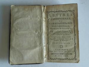
Lettres Chinoises ou correspondance philosophique, historique et critique, Entre un Chinois Voyageur, ses Correspondans a la Chine, en Moskovie, en Perse et au Japon
Seller: Celler Versandantiquariat, Eicklingen, Germany
Association Member: GIAQ
Seller rating 5 out of 5 stars
Pierre Paupie, ohne Ort, 1769. XXIV/329 S., Leder (R�cken eingerissen/etwas berieben und bestossen)--- - Text franz�sisch - 206 Gramm.
-
MEMOIRES SECRETS de la REPUBLIQUE des LETTRES ou LE THEATRE de le V�RIT� - 1737 � 1743 - 16 LETTRES 1 � 16 r�unies dans CINQ VOLUMES
Language: French
Seller: LA FRANCE GALANTE, Saint MARTIN sur LAVEZON, France
Seller rating 5 out of 5 stars
Couverture rigide. Condition: Bon. La Haye . Jean Neaulme / Amsterdam . Jacques Desbordes . 1737 � 1743 . Seize ouvrages en EDITION ORIGINALE ( Sauf la lettre 2 de 1751 ) , r�unis dans 5 volumes in-12 , 72 x 122 m/m , en reliure de l'�poque plein cuir .Manque les pieces de tomaison & une piece de titre . Tome I , 1737 ( sauf la 2 de 1751 ) 1 � 3 , 442 pages / Tome II , 1737 , 4 � 6 , 431 pages / Tome III , 1738 , 7 � 9 , pagin� 432 - 907 / Tome IV , 1738 - 1739 , 10 � 12 , pagin� 908 - 1076 & 202 p , 130 p / Tome V , 1740 & 1743 , 13 � 16 , 318 pages + 8 pages du catalogue de NEAULME .Editions m�lang�es de NEAULME ou DESBORDES . Sous 5 nouvelles pages de titre post�rieures de NEAULME . COMPLET des 16 lettres publi�es en 1743 , suivi du beau catalogue de NEAULME .
-
Theologia universa ad usum sacr� theologi� candidatorum. Authore R.P. Thoma ex Charmes,. Provinci� Lothoringi� Capuccinorum Definitore. Compendium Thelogi� Univers� ad usum examinandorum.
Published by Ex Typographia Balleoniana,, Venetiis,, 1764
Seller: Llibreria Antiqu�ria Els Gnoms, Sed�, L, Spain
Seller rating 4 out of 5 stars
2 obras en 3 vol�menes. XII- 555- IV-741- 110pp. �rbol geneal�gico plegado.
-

ESSEX County Map by Morden.
Published by London Edmund Gibson
Seller: John L. Capes (Books) Established 1969, STAITHES, United Kingdom
Association Member: PBFA
Seller rating 5 out of 5 stars
US$ 102.33
US$ 35.77 shipping
Ships from United Kingdom to U.S.A.Quantity: 1 available
Add to basketEngraved in 1695 and issued in Edmund Gibson's revised edition of Camden's Brittania. A Fine crisp copy with excellent colouring and good margins.approx 16.5"X14" plate size, imprint of Swall. Churchill & Partner.
-
![Seller image for Portr�t. Halbfigur im Oval. Kupferstich von M.B. [= Martin Bernigeroth], aufmontiert, 16 x 10 cm, o.J. for sale by Antiquariat Michael Eschmann](https://pictures.abebooks.com/inventory/md/md31158999367.jpg)
Portr�t. Halbfigur im Oval. Kupferstich von M.B. [= Martin Bernigeroth], aufmontiert, 16 x 10 cm, o.J.
Seller: Antiquariat Michael Eschmann, Gro�-Gerau, Germany
Seller rating 5 out of 5 stars
Art / Print / Poster
0. Etwas knittrig. Sprache: Deutschu.
-
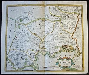
MIDDLESEX County Map by Morden.
Published by London Edmund Gibson, 1695
Seller: John L. Capes (Books) Established 1969, STAITHES, United Kingdom
Association Member: PBFA
Seller rating 5 out of 5 stars
US$ 136.44
US$ 35.77 shipping
Ships from United Kingdom to U.S.A.Quantity: 1 available
Add to basketEngraved in 1695 and issued in Edmund Gibson's revised edition of Camden's Brittania. A Fine crisp copy of this sought after county with excellent Colouring 16.5"X14.5" plate size, Imprint of Abel Swale. Awnsham & John Churchill publishers of the 1695 edn.
-
Lettres Juives ou Correspondence Philosophique, Historique et Critique entre un Juif voyageur en differens Etats de l'Europe et ses Correspondants en divers endroits. [Tomes Troisi�me, Cinqui�me et Sixieme].
Published by A La Haye, chez Pierre Paupie, 1766., 1766
Tres tomos (de seis) en 12vo.; XII pp., 382 pp. m�s XXIV pp., 392 pp. m�s XXIV pp., 374 pp. Ejemplares de salida, sin desbarbar. Cubiertas mudas en papel, de la �poca. Las subversivas "Lettres Juives" de D'Argens, disc�pulo de Voltaire y Bayle, son uno de los monumentos de la Ilustraci�n y de la defensa de la Tolerancia Religiosa. En su juventud el Marqu�s viaj� por el Norte de Africa y el Mediterr�neo Oriental hasta Constantinopla, como Secretario del Enviado franc�s y desde 1735 a 1740 vivi� en Holanda, donde escribi� �sta obra en la que se critica a la sociedad francesa bajo la ficci�n de cartas de un jud�o otomano, Aaron Moneca, a varios corresponsales.
-
Instrucci�n Pastoral del Se�or Arzobispo de Paris, Cristobal de Beaumont [sobre los atentados cometidos contra la Autoridad de la Iglesia por los Juezes de los Tribunales Seculares en el Negocio de los Jesuitas].
Published by [al fin:] "Impressa: en Valencia". Sin datos, de impresor, ni a�o, pero: hacia 1764., 1764
4to.; 2 hs., 251 pp., 10 hs. Encuadernaci�n de �poca, en pergamino.
-
OEUVRES MESL�ES DE MR. DE SAINT - EVREMOND . SECONDE EDITION REVE� CORREG�E eamp; AUGMENT�E
Published by Jacob Tonson, Londra, 1709
Seller: Il Cartiglio di Roberto Cena srlu, TORINO, TO, Italy
Seller rating 5 out of 5 stars
Legatura coeva in piena pelle marrone sbrinciata, dorso a 6 nervi decorati, con titolo, autore e numero di tomo in oro, tagli spruzzati di rosso e bruno.Vol I ritratto dell`autore inciso all`antiporta - (30) - LXXIV - (2) - (3) - 348 - (8) pagine numerate; Vol II (3) -ritratto dell`autore all`antiporta (6) - 456 - (12) pagine numerate; Vol III (10) - 464 - (12) pagine numerate.Opera in tre volumi, ognunopreceduto daun`antiporta con ritratto dell`autore (mancante nel III volume) e i frontespizi con grandemarca tipografica incisa; testatine e finalini silografati. Charles de Marguetel de Saint-Denis, seigneur de Saint-�vremond fu soldato francese, capitano nella Guerra dei Trent`anni, saggista e critico letterario.Le sue Ouvres Mesl�es, furono stampate da Jacob Tonsona Londra, in prima edizione nel 1705(2 volumi) e in 2a edizione nel 1709 in 3 volumi, come nel nostro caso. Esemplare in buone condizioni, salvo tracce di usura alle legature e ai dorsi e piccole fenditure o mancanze alle cerniere.
-

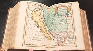
A New Mapp of the Estates of Savoy & Piedmont with the Countries Adjacent
Published by Robert Morden & Christopher Browne, London, 1703
Seller: Donald A. Heald Rare Books (ABAA), New York, NY, U.S.A.
Seller rating 5 out of 5 stars
Map
Copper-engraved map, with original outline colour, in very good condition overall. A very fine map of Savoy & Piedmont by two great English cartographers Robert Morden (d. 1703) was one of a new group of mapmakers who established the art of map publication in London on a permanent basis. As demonstrated in this excellent map of Savoy and Piedmont, Morden conveys the artistic and graphic standards of the late 17th century Dutch masters to English idiom. This is particularly true of the very fine engraving, evident here, that would not be typical of 18th century maps in general. Morden's early 18th century map of Savoy and Piedmont includes important topographical illustrations of this very mountainous region, but also, innovatively, main roads. The coats of arms of the House of Savoy, Piedmont and Tyrol are displayed around the title cartouche.
-
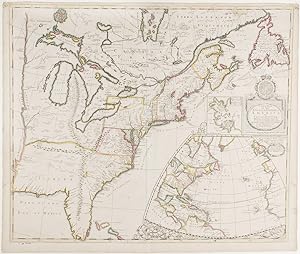
A New Map of the English Empire in America Viz Virginia Maryland Carolina Pennsylvania New York New Jersey New England by Rob: Morden
Published by "Sold by Robt. Morden at the Atlas in Cornhill./ And by Christopher Brown at ye Globe/ near the Westend of St. Pauls/ Church: London", [circa, London, 1695
Seller: Donald A. Heald Rare Books (ABAA), New York, NY, U.S.A.
Seller rating 5 out of 5 stars
Map
Copper-engraved map by John Harris, with original outline colour. A rare and important map of the American colonies, in the rare first state. This is in effect a propaganda map, compiled during the War of the League of Augsburg, or King William's War (1689-97). Morden shows the English American colonies thrusting westward, at the expense of the rival French claims. In addition to the Midwest, much of Canada is shown as English. The English colonies along the Atlantic Seaboard are carefully delineated according to English sources, but Canada, the Mississippi Valley, and the Great Lakes are based on French sources, including the maps of Dablon (1672) and Thevenot (1681). Morden still preserves Lederer's configuration (1672) in his depiction of the interior of the Southeast. At lower right is a large inset map of the North Atlantic, the vital life line between Britain and its American empire. Just above is the title piece crowned by the Royal Arms, and an inset map of Boston Harbor based on Thomas Pound's A New Mapp of New England from Cape Codd to Cape Sables (1691). The engraver, John Harris was one of the most accomplished members of his profession working in England. The insets are surrounded by decorative acanthus brackets and supports in the arabesque style, a signature motif of the artist. A second state was published in 1719 with the imprint of John Senex. Degrees of Latitude, pp. 358-360; Stevens & Tree, Comparative Cartography, 20a, in Tooley, The Mapping of America; McCorkle, New England in Early Printed Maps, 695; Cumming, The Southeast in Early Maps, 119; Phillips, A List of Maps of America, p. 564.
-

Le Canada, ou Nouvelle France.
Published by Paris: Pierre Mariette, 1656, 1656
Seller: Arader Galleries - AraderNYC, New York, NY, U.S.A.
Seller rating 5 out of 5 stars
Map
No Binding. Condition: Very Good. Copperplate map (Image: 15 1/2 x 21 1/2 in.; 39.4 x 54.6 cm), engraved by Jean Somer, partially handcolored in outline, decorative cartouche in lower right corner. BINDING/CONDITION: Matted and framed, not examined out of frame. A VERY BRIGHT AND CRISP IMPRESSION OF THE FIRST LARGE-SCALE MAP TO PRESENT ALL FIVE GREAT LAKES IN A COMPARATIVELY ACCURATE CORRELATION. "This delineation would considerably influence the cartography of the region for over 100 years; it was not to be superseded until Guillaume de L'Isle's Carte du Canada, in 1703" (Burden). Sanson's transformative map shows the entire Great Lakes region and the St. Lawrence River basin in detail. It names "L. Erie, ou du Chat" as a recognizable and distinct lake for the first time; the name derives from the native name "Derie" which referred to the "panther-like qualities of the feared local native Indians" (Burden). The northern waters remain the same with the exception of Hudson Bay, which is depicted in more detail. Sanson drew on source information from the Jesuit missionaries who ventured westward after Champlain's death and published annual accounts, or "Relations," of their findings between 1632 and 1673. This included Jean Nicollet's discovery of Lake Michigan, "Lac des Puans," in 1634 and Father Paul Ragueneau's "Relation" of 1648 which describes his visit to Niagara Falls, three decades before Father Louis Hennepin's formal description of the cataracts. Sanson also made several improvements in his east coast delineation: Long Island is introduced with New Amsterdam in its correct position. The Delaware River is more accurately shown, with "N[ouvelle] Su�de (the former Swedish colony of Fort Christina) at its mouth, the site of present-day Willmington. The borders of Virginia are defined but none of the English settlements are given. PROVENANCE: Anne H. & Frederick Vogel III (sale, Sotheby's New York, 19 January 2019, lot 1138); Martayan Lan Augustyn, New York, 2012 REFERENCES: Burden, The Mapping of North America, 318; Karpinski, Great Lakes Region,
-
Editio Secunda Fiorentina emendatior et auctior juxta S. Augustini Principia. Firenze, Tip. Formigli, s.d. 3 tomi in un vol. in 16, pp. 389, 399, 432, solida leg. m.perg. L'opera completa � in 7 tomi. L'Autore era Custode Generale dei Cappuccini della Provincia di Lotaringia e professore di teologia. Buone condizioni.
-

Un officier perd ses papiers lors de l'incendie du Fort-les-Bains.
Signed
1 pi�ce sign�e 1 p. In-folio 11 juin, 3 juillet et 4 ao�t 1722 Encre brune sur papier verg�. Tampon du Cabinet d'Hozier : fameux cabinet de g�n�alogie. Petites pliures et l�g�res usures du temps Pi�ce sign�e par le duc Louis d'Orl�ans (1703-1752),"Duc de Chartres,Premier prince du sang, Colonel g�n�ral de l'infanterie fran�oise et �trang�re". Certificatattestant des services du Sr de Falgueras, lieutenant du r�giment de l'Isle de France, ayant "perdu ses lettres en datte du mois de juin mil sept cent onze � l'incendie du fort des bains o� la compagnie est en garnison". Document contresign� par l'abb� oratorien Nicolas-Hubert Mongault, pr�cepteur du duc d'Orl�ans. Fils du R�gent, duc de Chartres puis duc d'Orl�ans (1723), protecteur des Lettres et des sciences, gouverneur du Dauphin� (1719).


![Seller image for Lettres Juives ou Correspondence Philosophique, Historique et Critique entre un Juif voyageur en differens Etats de l'Europe et ses Correspondants en divers endroits. [Tomes Troisi�me, Cinqui�me et Sixieme]. for sale by Hesperia Libros](https://pictures.abebooks.com/inventory/md/md5301661728.jpg)
![Seller image for Instrucci�n Pastoral del Se�or Arzobispo de Paris, Cristobal de Beaumont [sobre los atentados cometidos contra la Autoridad de la Iglesia por los Juezes de los Tribunales Seculares en el Negocio de los Jesuitas]. for sale by Hesperia Libros](https://pictures.abebooks.com/inventory/md/md22832939807.jpg)
